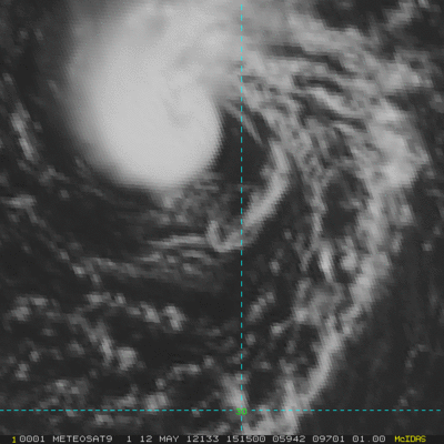
Hurricanehink wrote:I wish the NHC would at least put out an STWO. Not so much for our benefit, but to warn ships of the danger of this small, but well-organized and intensifying system.
Meteo-France did already mention this low in their last bulletins.
WONT50 LFPW 120740
A
SECURITE ON METAREA 2, METEO-FRANCE,
WARNING NR 189 , SATURDAY 12 MAY 2012 AT 0735 UTC
GENERAL SYNOPSIS, SATURDAY 12 AT 00 UTC
HIGH 1042 50N16W, MOVING EAST A, EXPECTED 1033 50N07W BY 13/12 UTC,
ASSOCIATED RIDGE EXTENDED TO WEST.
THUNDERY LOW 1016 33N32W, SLOW-MOVING AND DEEPENING, EXPECTED 1011
34N31W BY 13/12 UTC.
FINISTERRE CONTINUING TO 13/00 UTC. NORTHEAST, LOCALLY 8 NEAR CAPE.
GUSTS.
ACORES : CONTINUING TO 12/18 UTC. NORTHEASTERLY LOCALLY 8 IN WEST.
GUSTS. CADIZ, GIBRALTAR STRAIT : CONTINUING TO 12/21 UTC. EAST 8 IN
AND LEEWARD STRAIT. SEVERE GUSTS.=
Also (I've removed most of the forecast areas here):
FQNT50 LFPW 120744
A
SECURITE
Weather bulletin for METAREA 2, METEO-FRANCE,
Toulouse, Saturday 12 May 2012 at 1015 UTC.
- Wind speed in BEAUFORT SCALE - Sea : Total significant -
- Please be aware, wind gusts can be a further 40 percent stronger
than the averages given here, and maximum waves may be up to twice
the significant height.
Part 1 : WARNING : 189
Part 2 : General synopsis, Saturday 12 at 00 UTC
Thundery low 1016 33N32W, slow-moving and deepening, expected
1011 34N31W by 13/12 UTC.
High 1042 50N16W, moving east a, expected 1033 50N07W by 13/12
UTC, associated ridge extended to west.
New high expected 1038 46N33W by 13/00UTC, moving west, expected
1036 47N39W by 13/12UTC.
ITCZ axis along 09N13W 08N20W 07N25W 03N39W.
Part 3 : Area forecasts to Sunday 13 at 12 UTC
ACORES :
In west : Northeasterly 5 to 7 locally 8, decreasing 4 or 6 later
temporarily 7 in northwest. Gusts. In east : Easterly 4 to 6,
decreasing 3 to 5 later. Rough or very rough in west, moderate or
rough in east. Thundery showers, squalls with gusts.
IRVING :
Cyclonic 4 to 6 locally 7, decreasing 3 to 5 locally 6 later.
Gusts. Rough in west, locally very rough in northwest at first,
moderat ein east, Northerly swell. Thundery showers, squalls with
gusts.
METEOR :
In west : Westerly 4 to 6 locally 3 in south, decreasing 3 or 4
later occasionally 5 in north, backing West or Southwest 3 or 4 at
end. In east : Northerly 2 to 4 locally 5 in far east. Moderate,
but rough in northwest, Northerly swell. Some thundery showers in
north.
Part 4 : outlook for next 24 hours :
Threat of Northeast near gale over FINISTERRE.
Threat of Easterly near gale over JOSEPHINE on monday.
Elsewhere no significant phenomenon expected.