
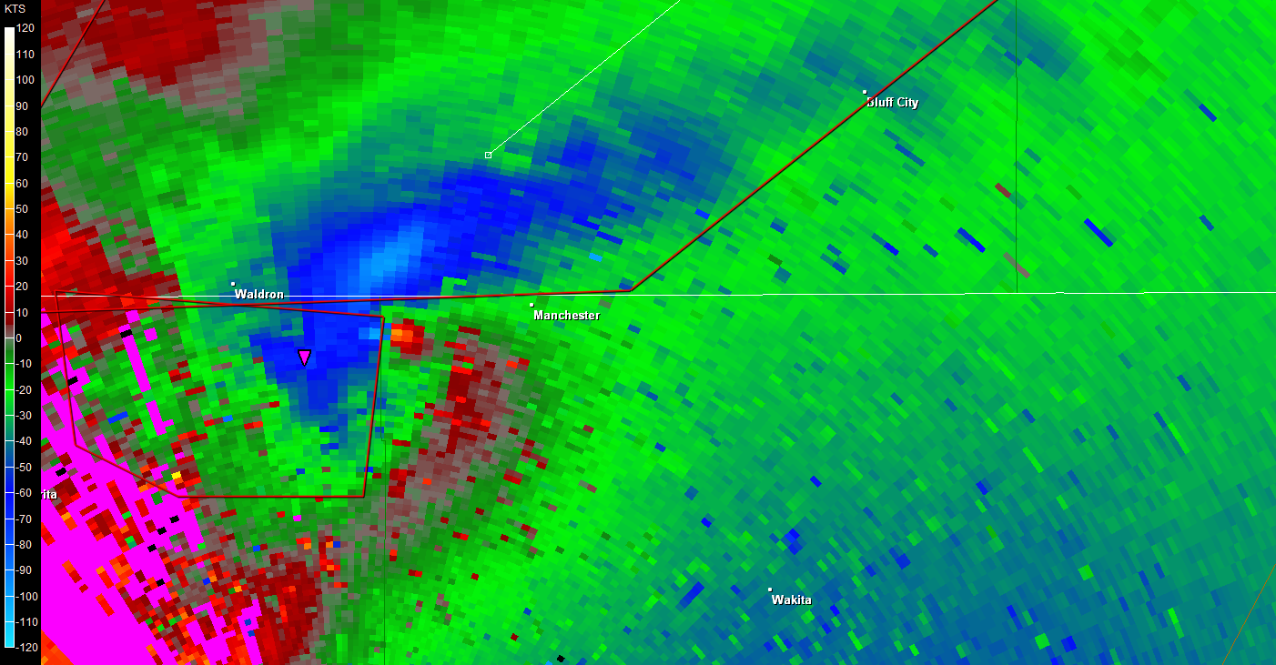
New warning on Byron tornado issued by WFO Wichita ahead of storm crossing KS/OK border.
THE NATIONAL WEATHER SERVICE IN WICHITA HAS ISSUED A
* TORNADO WARNING FOR...
HARPER COUNTY IN SOUTH CENTRAL KANSAS...
* UNTIL 900 PM CDT
* AT 819 PM CDT...A CONFIRMED TORNADO WAS LOCATED NEAR BYRON OVER
NORTHERN OKLAHOMA...AND MOVING NORTHEAST AT 30 MPH.
HAZARD...DAMAGING TORNADO AND TENNIS BALL SIZE HAIL.
SOURCE...SPOTTER CONFIRMED TORNADO.
IMPACT...SIGNIFICANT HOUSE AND BUILDING DAMAGE POSSIBLE. MOBILE
HOMES COMPLETELY DESTROYED IF HIT. SOME TREES UPROOTED OR
SNAPPED. VEHICLES WILL LIKELY BE THROWN BY TORNADIC WINDS.
* LOCATIONS IMPACTED INCLUDE...
ANTHONY...WALDRON AND BLUFF CITY.
Plains Tornado Outbreak 4/14-15
Moderator: S2k Moderators
Forum rules

The posts in this forum are NOT official forecast and should not be used as such. They are just the opinion of the poster and may or may not be backed by sound meteorological data. They are NOT endorsed by any professional institution or STORM2K.
-
brunota2003

- S2K Supporter

- Posts: 9476
- Age: 35
- Joined: Sat Jul 30, 2005 9:56 pm
- Location: Stanton, KY...formerly Havelock, NC
- Contact:
Re: Plains Tornado Outbreak: High Risk on 4/14-15 at OK,KS,NEB
North of Cherokee, OK...holy cow!


Last edited by brunota2003 on Sat Apr 14, 2012 8:33 pm, edited 1 time in total.
0 likes


-
Texas Snowman

- Storm2k Moderator

- Posts: 6197
- Joined: Fri Jan 25, 2008 11:29 am
- Location: Denison, Texas
Mike Bettes of TWC: Greensburg, KS take shelter immediately!
0 likes
The above post and any post by Texas Snowman is NOT an official forecast and should not be used as such. It is just the opinion of the poster and may or may not be backed by sound meteorological data. It is NOT endorsed by any professional institution including storm2k.org. For official information, please refer to NWS products.
-
HurricaneBill
- Category 5

- Posts: 3419
- Joined: Sun Apr 11, 2004 5:51 pm
- Location: East Longmeadow, MA, USA
Re:
Texas Snowman wrote:Several sources reporting large wedge on ground two miles west of Goessel, Kansas.
Goessel was hit by an F5 in 1990.
0 likes
-
Texas Snowman
- Storm2k Moderator
- Posts: 6197
- Joined: Fri Jan 25, 2008 11:29 am
- Location: Denison, Texas
News9: Big tornado on the ground SW of Manchester. Debris ball showing up on the TV's radar (Gary England's station?).
0 likes
The above post and any post by Texas Snowman is NOT an official forecast and should not be used as such. It is just the opinion of the poster and may or may not be backed by sound meteorological data. It is NOT endorsed by any professional institution including storm2k.org. For official information, please refer to NWS products.
-
apocalypt-flyer
- Category 1

- Posts: 468
- Joined: Sat Aug 27, 2005 11:51 am
The OK/Kansas tornadic system with debris ball on the radar. Heading towards Manchester OK.
Last edited by apocalypt-flyer on Sat Apr 14, 2012 8:41 pm, edited 2 times in total.
0 likes
-
apocalypt-flyer
- Category 1
- Posts: 468
- Joined: Sat Aug 27, 2005 11:51 am
Re:
Texas Snowman wrote:News9: Big tornado on the ground SW of Manchester. Debris ball showing up on the TV's radar (Gary England's station?).
Yeah, it's on News9.
0 likes
-
brunota2003
- S2K Supporter
- Posts: 9476
- Age: 35
- Joined: Sat Jul 30, 2005 9:56 pm
- Location: Stanton, KY...formerly Havelock, NC
- Contact:
Re: Plains Tornado Outbreak: High Risk on 4/14-15 at OK,KS,NEB
Most likely very, very violent tornado on the ground crossing into Kansas...

0 likes
-
CrazyC83
- Professional-Met

- Posts: 34315
- Joined: Tue Mar 07, 2006 11:57 pm
- Location: Deep South, for the first time!
Re: Plains Tornado Outbreak: High Risk on 4/14-15 at OK,KS,NEB
WWUS53 KICT 150136
SVSICT
SEVERE WEATHER STATEMENT
NATIONAL WEATHER SERVICE WICHITA KS
836 PM CDT SAT APR 14 2012
KSC077-150200-
/O.CON.KICT.TO.W.0025.000000T0000Z-120415T0200Z/
HARPER KS-
836 PM CDT SAT APR 14 2012
...A TORNADO WARNING REMAINS IN EFFECT FOR HARPER COUNTY UNTIL 900 PM
CDT...
AT 831 PM CDT...A CONFIRMED LARGE AND EXTREMELY DANGEROUS TORNADO WAS
LOCATED NEAR WALDRON...AND MOVING NORTHEAST AT 40 MPH.
THIS IS A PARTICULARLY DANGEROUS SITUATION.
HAZARD...DAMAGING TORNADO.
SOURCE...WEATHER SPOTTERS CONFIRMED TORNADO.
IMPACT...MAJOR HOUSE AND BUILDING DAMAGE LIKELY AND COMPLETE
DESTRUCTION POSSIBLE. NUMEROUS TREES SNAPPED. MAJOR POWER
OUTAGES IN PATH OF TORNADO HIGHLY LIKELY. SOME ROADS
POSSIBLY BLOCKED BY TORNADO DEBRIS. COMPLETE DESTRUCTION OF
VEHICLES LIKELY.
LOCATIONS IMPACTED INCLUDE...
ANTHONY AND BLUFF CITY.
PRECAUTIONARY/PREPAREDNESS ACTIONS...
TO REPEAT...A LARGE...EXTREMELY DANGEROUS AND POTENTIALLY DEADLY
TORNADO IS ON THE GROUND. TO PROTECT YOUR LIFE...TAKE COVER NOW. MOVE
TO AN INTERIOR ROOM ON THE LOWEST FLOOR OF A STURDY BUILDING. AVOID
WINDOWS. IF IN A MOBILE HOME...A VEHICLE OR OUTDOORS...MOVE TO THE
CLOSEST SUBSTANTIAL SHELTER AND PROTECT YOURSELF FROM FLYING DEBRIS.
TORNADOES ARE DIFFICULT TO SEE AND CONFIRM AT NIGHT. TAKE COVER NOW.
&&
LAT...LON 3700 9833 3731 9810 3715 9780 3712 9780
3700 9799 3699 9833
TIME...MOT...LOC 0136Z 230DEG 35KT 3701 9809
TORNADO...OBSERVED
TORNADO DAMAGE THREAT...SIGNIFICANT
HAIL...2.50IN
$$
KLEINSASSER
0 likes
-
Texas Snowman
- Storm2k Moderator
- Posts: 6197
- Joined: Fri Jan 25, 2008 11:29 am
- Location: Denison, Texas
Manchester has a population of 104.
0 likes
The above post and any post by Texas Snowman is NOT an official forecast and should not be used as such. It is just the opinion of the poster and may or may not be backed by sound meteorological data. It is NOT endorsed by any professional institution including storm2k.org. For official information, please refer to NWS products.
TORCONs have been upgraded, obviously.
Saturday April 14
IA northwest 3 - 4
IA southwest - 5
IA south-central - 4
IA northeast night - 2
[b]IA west night - 7
KS central - 9[/b]
KS east - 5
KS central, northeast night - 9
KS near Wichita night - 7
MN extreme southwest - 2
MN south night - 4
MO northwest, west-central - 4
MO northwest night - 7
NE south - central - 9
NE north - central - 5
NE central night - 8
NE east - 7
NE east - 6, night - 7
OK northwest - 9
OK southwest, central - 7
OK northeast - 5
SD southeast - 2
SD southeast night - 3
TX east panhandle - 7
TX northwest east of Midland to Wichita Falls - 4
TX northwest near San Angelo to Wichita Falls night - 5
WI west-central,southwest night - 2
Last edited by Bunkertor on Sat Apr 14, 2012 8:43 pm, edited 1 time in total.
0 likes
-
CrazyC83
- Professional-Met
- Posts: 34315
- Joined: Tue Mar 07, 2006 11:57 pm
- Location: Deep South, for the first time!
Re: Plains Tornado Outbreak: High Risk on 4/14-15 at OK,KS,NEB
SEL2
URGENT - IMMEDIATE BROADCAST REQUESTED
SEVERE THUNDERSTORM WATCH NUMBER 172
NWS STORM PREDICTION CENTER NORMAN OK
840 PM CDT SAT APR 14 2012
THE NWS STORM PREDICTION CENTER HAS ISSUED A
SEVERE THUNDERSTORM WATCH FOR PORTIONS OF
SOUTHEAST IOWA
NORTHWEST ILLINOIS
EFFECTIVE THIS SATURDAY NIGHT AND SUNDAY MORNING FROM 840 PM
UNTIL 100 AM CDT.
HAIL TO 1.5 INCHES IN DIAMETER...THUNDERSTORM WIND GUSTS TO 70
MPH...AND DANGEROUS LIGHTNING ARE POSSIBLE IN THESE AREAS.
THE SEVERE THUNDERSTORM WATCH AREA IS APPROXIMATELY ALONG AND 45
STATUTE MILES NORTH AND SOUTH OF A LINE FROM 20 MILES SOUTH OF
MOLINE ILLINOIS TO 70 MILES WEST NORTHWEST OF BURLINGTON IOWA.
FOR A COMPLETE DEPICTION OF THE WATCH SEE THE ASSOCIATED WATCH
OUTLINE UPDATE (WOUS64 KWNS WOU2).
REMEMBER...A SEVERE THUNDERSTORM WATCH MEANS CONDITIONS ARE
FAVORABLE FOR SEVERE THUNDERSTORMS IN AND CLOSE TO THE WATCH
AREA. PERSONS IN THESE AREAS SHOULD BE ON THE LOOKOUT FOR
THREATENING WEATHER CONDITIONS AND LISTEN FOR LATER STATEMENTS
AND POSSIBLE WARNINGS. SEVERE THUNDERSTORMS CAN AND OCCASIONALLY
DO PRODUCE TORNADOES.
OTHER WATCH INFORMATION...CONTINUE...WW 167...WW 169...WW
170...WW 171...
DISCUSSION...BOW ECHO OVER CNTRL IA WILL CONTINUE EWD AT 40-50 KT
WITHIN TERMINUS OF 50-60 KT LLJ. DAMAGING WINDS AND SEVERE HAIL
WILL BE POSSIBLE WITH THIS SYSTEM BEFORE IT BEGINS TO WEAKEN NEAR OR
JUST E OF THE MS RIVER.
AVIATION...A FEW SEVERE THUNDERSTORMS WITH HAIL SURFACE AND ALOFT
TO 1.5 INCHES. EXTREME TURBULENCE AND SURFACE WIND GUSTS TO 60
KNOTS. A FEW CUMULONIMBI WITH MAXIMUM TOPS TO 400. MEAN STORM
MOTION VECTOR 27040.
...MEAD
0 likes
-
brunota2003
- S2K Supporter
- Posts: 9476
- Age: 35
- Joined: Sat Jul 30, 2005 9:56 pm
- Location: Stanton, KY...formerly Havelock, NC
- Contact:
-
Florida1118
Re: Plains Tornado Outbreak: High Risk on 4/14-15 at OK,KS,NEB
Per Dr.Forbes, will head north of Manchester.brunota2003 wrote:It's heading almost right for Manchester...it'll probably pass just west/north of the dot...by maybe a mile...or a hit on the town.
0 likes
-
CrazyC83
- Professional-Met
- Posts: 34315
- Joined: Tue Mar 07, 2006 11:57 pm
- Location: Deep South, for the first time!
Re: Plains Tornado Outbreak: High Risk on 4/14-15 at OK,KS,NEB
WWUS53 KDDC 150138
SVSDDC
SEVERE WEATHER STATEMENT
NATIONAL WEATHER SERVICE DODGE CITY KS
838 PM CDT SAT APR 14 2012
KSC047-097-145-151-185-150200-
/O.CON.KDDC.TO.W.0029.000000T0000Z-120415T0200Z/
STAFFORD KS-PRATT KS-PAWNEE KS-KIOWA KS-EDWARDS KS-
838 PM CDT SAT APR 14 2012
...A TORNADO WARNING REMAINS IN EFFECT FOR EDWARDS...NORTHERN
KIOWA...EASTERN PAWNEE...NORTHWESTERN PRATT AND STAFFORD COUNTIES
UNTIL 900 PM CDT...
AT 836 PM CDT...NATIONAL WEATHER SERVICE DOPPLER RADAR INDICATED VERY
STRONG ROTATION ASSOCIATED WITH A CONFIRMED TORNADO NEAR FELLSBURG.
THIS TORNADIC STORM WAS MOVING NORTHEAST AT 80 MPH. DANGEROUS AND
EXTREMELY DESTRUCTIVE HAIL UP TO SOFTBALL SIZE IS ALSO EXPECTED WITH
THIS STORM.
AT 836 PM...A TORNADO WAS REPORTED BY THE PUBLIC 2 MILES WEST
NORTHWEST OF GREENSBURG.
LOCATIONS IMPACTED INCLUDE...
FELLSBURG...
TROUSDALE...
BELPRE...
MACKSVILLE...
RADIUM...
SEWARD...
MAINLY RURAL AREAS OF EASTERN PAWNEE...EDWARDS...NORTHERN KIOWA...
NORTHWESTERN PRATT AND STAFFORD COUNTIES.
PRECAUTIONARY/PREPAREDNESS ACTIONS...
TO REPEAT...A TORNADO IS CONFIRMED WITH THIS STORM. TAKE COVER NOW.
MOVE TO AN INTERIOR ROOM ON THE LOWEST FLOOR OF A STURDY BUILDING.
AVOID WINDOWS. IF IN A MOBILE HOME...A VEHICLE OR OUTDOORS...MOVE TO
THE CLOSEST SUBSTANTIAL SHELTER AND PROTECT YOURSELF FROM FLYING
DEBRIS.
&&
LAT...LON 3754 9927 3762 9955 3835 9927 3811 9846
TIME...MOT...LOC 0137Z 219DEG 69KT 3780 9917
HAIL 4.25IN
$$
RUSSELL
0 likes
Return to “USA & Caribbean Weather”
Who is online
Users browsing this forum: No registered users and 119 guests