

Steve McCauley said this today on his facebook:
"Chaos too high to put too much confidence in long-range predictions, but certainly something to watch since some of the data are trying to form a psuedo-McFarland toward the end of the month."
Texas Winter 2011-2012...
Moderator: S2k Moderators
Forum rules
 The posts in this forum are NOT official forecast and should not be used as such. They are just the opinion of the poster and may or may not be backed by sound meteorological data. They are NOT endorsed by any professional institution or STORM2K.

The posts in this forum are NOT official forecast and should not be used as such. They are just the opinion of the poster and may or may not be backed by sound meteorological data. They are NOT endorsed by any professional institution or STORM2K.
Re: Texas Winter 2011-2012...
0 likes
-
Texas Snowman

- Storm2k Moderator

- Posts: 6197
- Joined: Fri Jan 25, 2008 11:29 am
- Location: Denison, Texas
Re: Texas Winter 2011-2012...
Portastorm wrote:Texas Snowman, I've been burned too many times this winter by these "oh, the cold is coming in just 9-10 days" runs by both the GFS and European. They've both broken my heart this season.
If we see this kind of scenario on the models by this weekend, I may change my assessment and hop aboard the Orangeblood Polar Express.
Heat Miser (wxman57) has the hot hand, so to speak, this winter. Hard to deny it.
Granted, I'm much further north than you are. Heck, I'm only in Texas by five miles!!!
But I've seen one too many good March snowfalls to throw in the towel just yet. In fact, several of the snows I've seen up here in March were among the biggest we've ever had in my 30 years here.
Heck, I even remember Waco and portions of Central Texas getting some snow a few years ago in April. And as memory serves, a few years before that, Abilene and the Big Country got BURIED by an early April snow. I think Abilene ended up measuring more than a foot of wet, slushy snow out of that.
Odds are against us. Days of potential winter weather are dwindling fast. But I'm not giving up until that plump woman has sung.
(BTW, if we don't get a good dose of winter weather before spring, the PWC needs to be leading the way in plotting our El Nino winter revenge against Heat Miser for 2012-13
0 likes
The above post and any post by Texas Snowman is NOT an official forecast and should not be used as such. It is just the opinion of the poster and may or may not be backed by sound meteorological data. It is NOT endorsed by any professional institution including storm2k.org. For official information, please refer to NWS products.
-
Texas Snowman
- Storm2k Moderator
- Posts: 6197
- Joined: Fri Jan 25, 2008 11:29 am
- Location: Denison, Texas
Re: Texas Winter 2011-2012...
Portastorm wrote:Heat Miser (wxman57) has the hot hand, so to speak, this winter. Hard to deny it.
You know, the irony here is that while it is true that wxman57 has enjoyed the winter of his dreams thus far, just the opposite is true in much of the rest of the northern hemisphere.
While the winter of 2011-12 may indeed go down as the "Winter that Wasn't" in the Lower 48 with little cold, little snow, and the Great Lakes remaining ice free, millions and millions of other people will remember this winter as the one from a cold corner of Hades.
Europe, Russia, parts of Asia, Alaska and portions of Canada have paid the price for our mild weather in terms of their own historic snow, cold, and prolonged deep freezes.
0 likes
The above post and any post by Texas Snowman is NOT an official forecast and should not be used as such. It is just the opinion of the poster and may or may not be backed by sound meteorological data. It is NOT endorsed by any professional institution including storm2k.org. For official information, please refer to NWS products.
-
Texas Snowman
- Storm2k Moderator
- Posts: 6197
- Joined: Fri Jan 25, 2008 11:29 am
- Location: Denison, Texas
Re: Texas Winter 2011-2012...
iorange55 wrote:Steve McCauley said this today on his facebook:
"Chaos too high to put too much confidence in long-range predictions, but certainly something to watch since some of the data are trying to form a psuedo-McFarland toward the end of the month."
Now THAT would be the way to finish the winter off here in Texas!
0 likes
The above post and any post by Texas Snowman is NOT an official forecast and should not be used as such. It is just the opinion of the poster and may or may not be backed by sound meteorological data. It is NOT endorsed by any professional institution including storm2k.org. For official information, please refer to NWS products.

The AO is currently positive. We will have to wait for it to return to negative territory again for FRESH cold air which is forecasted for the end of the month (possibly). Clock is ticking and the cold air we have around now in Canada is old bleh. Good thing the PNA was so positive or else we would be torching right now (courtesy of the MJO)!
0 likes
The above post and any post by Ntxw is NOT an official forecast and should not be used as such. It is just the opinion of the poster and may or may not be backed by sound meteorological data. It is NOT endorsed by any professional institution including Storm2k. For official information, please refer to NWS products.
Help support Storm2K!
-
SouthernMet

- Category 3

- Posts: 857
- Joined: Sun Aug 29, 2010 8:23 pm
- Location: fort worth, tx
Re: Texas Winter 2011-2012...
My head says Orangeblood.
0 likes
Nothing that SouthernMet posts, is an official forecast,nor does it reflect views of STORM2K.. SouthernMet is just adding to the great discussions on STORM2K.. Refer to NWS for official forecasts.
-
Rgv20

- S2K Supporter

- Posts: 2466
- Age: 39
- Joined: Wed Jan 05, 2011 5:42 pm
- Location: Edinburg/McAllen Tx
Special Weather Statement
SPECIAL WEATHER STATEMENT
NATIONAL WEATHER SERVICE BROWNSVILLE TX
859 PM CST THU FEB 16 2012
TXZ248>257-171130-
ZAPATA-JIM HOGG-BROOKS-KENEDY-STARR-HIDALGO-INLAND WILLACY-
INLAND CAMERON-COASTAL WILLACY-COASTAL CAMERON-
INCLUDING THE CITIES OF...ZAPATA...HEBBRONVILLE...FALFURRIAS...
SARITA...RIO GRANDE CITY...ROMA...MCALLEN...EDINBURG...PHARR...
MISSION...WESLACO...RAYMONDVILLE...BROWNSVILLE...HARLINGEN...
PORT MANSFIELD...PORT ISABEL...SOUTH PADRE ISLAND...
LAGUNA HEIGHTS...LAGUNA VISTA
859 PM CST THU FEB 16 2012
...STRONG STORM SYSTEM TO MOVE ACROSS THE RIO GRANDE VALLEY AND
DEEP SOUTH TEXAS FRIDAY AND SATURDAY...
AREAS OF SHOWER AND THUNDERSTORM ACTIVITY ARE EXPECTED TO CONTINUE
TO DEVELOP AHEAD OF A STRONG LOW PRESSURE SYSTEM BUILDING IN
NORTHWESTERN MEXICO THROUGH FRIDAY NIGHT. THIS AREA OF LOW PRESSURE
WILL MOVE EAST AND PUSH ACROSS SOUTH TEXAS FRIDAY NIGHT INTO
SATURDAY MORNING. STRONG THUNDERSTORMS WILL BE POSSIBLE...MAINLY
FRIDAY IN THE LATE AFTERNOON AND OVERNIGHT. STRONGER STORMS WILL
BE CAPABLE OF PRODUCING HAIL...MOSTLY PEA TO NICKEL SIZE...WITH
HAIL TO QUARTER SIZE OR LARGER POSSIBLE IN THE STRONGEST
STORMS...GUSTY WINDS OF 30 TO 40 MPH...HEAVY RAIN...AND FREQUENT
LIGHTNING.
ONCE THE FRONT MOVES THROUGH...VERY STRONG WINDS ARE EXPECTED FROM
THE WEST AND NORTHWEST. WINDS OF 30 TO 40 MPH WILL BE
POSSIBLE...AND GUSTS MAY APPROACH 50 TO 60 MPH IF THE STORM IS AS
STRONG AS CURRENTLY FORECAST. THESE WINDS WILL BE MOST LIKELY FROM
AROUND MID MORNING SATURDAY...THROUGH SATURDAY EVENING. A WIND
ADVISORY OR A HIGH WIND WARNING MAY BECOME REQUIRED FOR THE AREA
AS THE STORM GETS CLOSER.
RAINFALL IS EXPECTED TO BE IN THE FORM OF ON AND OFF SHOWERS WITH
MOST AREAS SEEING AROUND A TENTH TO A QUARTER OF AN INCH...WITH
LOCALLY HIGHER AMOUNTS IN AREAS THAT EXPERIENCE THUNDERSTORMS.
MONITOR WEATHER.GOV/RGV FOR UPDATED FORECASTS.
$$
GIBBS
0 likes
The following post is NOT an official forecast and should not be used as such. It is just the opinion of the poster and may or may not be backed by sound meteorological data. It is NOT endorsed by any professional institution including storm2k.org For Official Information please refer to the NHC and NWS products.
-
Rgv20
- S2K Supporter
- Posts: 2466
- Age: 39
- Joined: Wed Jan 05, 2011 5:42 pm
- Location: Edinburg/McAllen Tx
Looks like the radar is going to light up tonight 
SPC AC 171230
DAY 1 CONVECTIVE OUTLOOK
NWS STORM PREDICTION CENTER NORMAN OK
0630 AM CST FRI FEB 17 2012
VALID 171300Z - 181200Z
...THERE IS A SLGT RISK OF SVR TSTMS OVER PARTS OF SOUTH TX...
...TX...
MORNING WATER VAPOR IMAGERY CONTINUES TO SHOW A LARGE UPPER LOW
CENTERED OVER NORTHWEST MEXICO. THIS FEATURE IS FORECAST TO TRACK
EASTWARD AND INTO TX THIS EVENING. AHEAD OF THE LOW...SOUTHERLY LOW
LEVEL WINDS ARE DRAWING AN INCREASINGLY MOIST AIR MASS FROM THE
WESTERN GULF OF MEXICO INTO TX. NORTHWARD RETURN OF SURFACE
MOISTURE/INSTABILITY WILL BE LIMITED BY A WARM FRONT ACROSS SOUTH
TX. HOWEVER...WARM/MOIST ADVECTION ABOVE THE SURFACE WILL HELP
DESTABILIZE THE LOW LEVEL AIR MASS AS FAR NORTH AS CENTRAL TX BY
EARLY SAT MORNING.
PRESENT INDICATIONS ARE THAT ISOLATED THUNDERSTORMS WILL BE POSSIBLE
THROUGHOUT THE FORECAST PERIOD OVER SOUTH AND CENTRAL TX.
HOWEVER...THE IT APPEARS THE BULK OF CONVECTION AND ASSOCIATED
SEVERE THREAT WILL BE AFTER DARK AS THE UPPER LOW APPROACHES AND LOW
LEVEL CYCLOGENESIS OCCURS. STRENGTHENING LOW LEVEL WINDS WILL
ENHANCE WARM/MOIST ADVECTION AND LIFT OVER MUCH OF TX. FORECAST
SOUNDINGS SHOW STEEPENING LAPSE RATES AND SUFFICIENT DEEP LAYER
VERTICAL SHEAR FOR CONVECTIVE ORGANIZATION. BOW/LEWP STRUCTURES
APPEAR TO BE THE MOST LIKELY STORM MODE WITH DAMAGING WINDS AND HAIL
IN THE STRONGER CELLS...ESPECIALLY OVER SOUTH TX WHERE SURFACE-BASED
PARCELS ARE MOST LIKELY.
..HART/MOSIER/ROGERS.. 02/17/2012
CLICK TO GET WUUS01 PTSDY1 PRODUCT
0 likes
The following post is NOT an official forecast and should not be used as such. It is just the opinion of the poster and may or may not be backed by sound meteorological data. It is NOT endorsed by any professional institution including storm2k.org For Official Information please refer to the NHC and NWS products.
-
Portastorm

- Storm2k Moderator
- Posts: 9955
- Age: 63
- Joined: Fri Jul 11, 2003 9:16 am
- Location: Round Rock, TX
- Contact:
Re: Texas Winter 2011-2012...
Alright ... after two major cycle updates with the GFS and Euro since yesterday's dramatic 12z GFS run. Both models are still indicating a major cold blast coming into the nation's midsection around the 240-hour, 10-day mark. Neither one though are showing anything exceptionally noteworthy at this time for most of Texas (snow for the Panhandle and top edge of the South Plains maybe).
I think the main point to keep in mind is that we are seeing agreement this far out for something to happen toward the end of the month and it looks to be a major storm system. It should be fun to watch this one unfold.
I think the main point to keep in mind is that we are seeing agreement this far out for something to happen toward the end of the month and it looks to be a major storm system. It should be fun to watch this one unfold.
0 likes
Any forecasts under my name are to be taken with a grain of salt. Get your best forecasts from the National Weather Service and National Hurricane Center.
-
Rgv20
- S2K Supporter
- Posts: 2466
- Age: 39
- Joined: Wed Jan 05, 2011 5:42 pm
- Location: Edinburg/McAllen Tx
It is going to be very very windy come Saturday for the RGV!
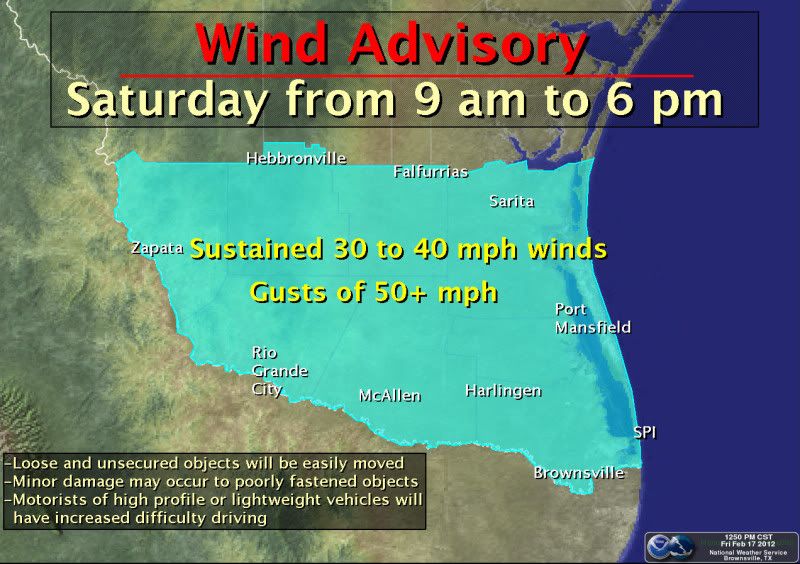
A Wind Advisory is in effect Saturday, from 9 am to 6 pm, for all of Deep South Texas and the Rio Grande Valley. Winds will shift from the southeast to the northwest and increase in the late morning. Sustained winds of 30 to 40 mph are expected with some gusts exceeding 50 mph. Residents and visitors of the Rio Grande Valley and Deep South Texas should be sure to secure outside objects or bring them inside. Loose and unsecured objects, such as trash cans and lawn ornaments will be easily moved around or damaged by the strong winds. Individuals working above ground level, such as on ladders or roofs, will experience difficulty maintaining their balance. Motorists operating high profile and lightweight vehicles, especially along Highway 281 between Pharr and Falfurrias, and along Expressway 77 between Brownsville and Sarita, will have increased difficulty driving in the windy conditions.-Billings-
A Wind Advisory is in effect Saturday, from 9 am to 6 pm, for all of Deep South Texas and the Rio Grande Valley. Winds will shift from the southeast to the northwest and increase in the late morning. Sustained winds of 30 to 40 mph are expected with some gusts exceeding 50 mph. Residents and visitors of the Rio Grande Valley and Deep South Texas should be sure to secure outside objects or bring them inside. Loose and unsecured objects, such as trash cans and lawn ornaments will be easily moved around or damaged by the strong winds. Individuals working above ground level, such as on ladders or roofs, will experience difficulty maintaining their balance. Motorists operating high profile and lightweight vehicles, especially along Highway 281 between Pharr and Falfurrias, and along Expressway 77 between Brownsville and Sarita, will have increased difficulty driving in the windy conditions.-Billings-
0 likes
The following post is NOT an official forecast and should not be used as such. It is just the opinion of the poster and may or may not be backed by sound meteorological data. It is NOT endorsed by any professional institution including storm2k.org For Official Information please refer to the NHC and NWS products.
Re:
gpsnowman wrote:Man this place is dead. I am still reading that a cool down is in store for a good portion of the lower 48 late Feb into early March. What does this mean for Texas? Who knows but this might be our last chance!
Until we see very cold air in Canada (not yet) and until we see the pattern is right at the right time (not yet), it's all model speculation. This season's trend say expect a transient cold shot. It's late Feb and under sub 20 temps for Dallas and Houston is highly unlikely. Do expect the cool and damp conditions to continue though. That doesn't mean we can't get snow
0 likes
The above post and any post by Ntxw is NOT an official forecast and should not be used as such. It is just the opinion of the poster and may or may not be backed by sound meteorological data. It is NOT endorsed by any professional institution including Storm2k. For official information, please refer to NWS products.
Help support Storm2K!
Help support Storm2K!
-
Portastorm
- Storm2k Moderator
- Posts: 9955
- Age: 63
- Joined: Fri Jul 11, 2003 9:16 am
- Location: Round Rock, TX
- Contact:
Re: Texas Winter 2011-2012...
The GFS, Euro, and Canadian are still showing some kind of major cold front for the Southern Plains/Texas around Feb. 26-27. All three have been fairly consistent for the last several days showing this. I definitely have increased confidence in that scenario verifying. But ... what kind of "cold" will it be? Will it be seasonal cold? Very below normal cold? Too soon to tell in my opinion. As wxman57 always says, "watch the source regions."
I wouldn't even attempt to venture a guess at this time about frozen precip or lack thereof.
I wouldn't even attempt to venture a guess at this time about frozen precip or lack thereof.
0 likes
Any forecasts under my name are to be taken with a grain of salt. Get your best forecasts from the National Weather Service and National Hurricane Center.
-
wxman57

- Moderator-Pro Met

- Posts: 23175
- Age: 68
- Joined: Sat Jun 21, 2003 8:06 pm
- Location: Houston, TX (southwest)
Re: Texas Winter 2011-2012...
Still nothing to indicate any really cold air and/or frozen precip in TX (except maybe for the northern panhandle) for the next few weeks, and likely this winter. No indication of any significant pattern change. Continued wet and cool. Yuck! 18 inches of rain in 6 weeks is quite enough. Someone else can have some rain now...
0 likes
You heard it here first folks! Take it while it's still hot! Everytime Wxman57 cancels winter for good something magical usually happens . Lets hope the streak continues 
0 likes
The above post and any post by Ntxw is NOT an official forecast and should not be used as such. It is just the opinion of the poster and may or may not be backed by sound meteorological data. It is NOT endorsed by any professional institution including Storm2k. For official information, please refer to NWS products.
Help support Storm2K!
Help support Storm2K!

Re: Texas Winter 2011-2012...
wxman57 wrote:Still nothing to indicate any really cold air and/or frozen precip in TX (except maybe for the northern panhandle) for the next few weeks, and likely this winter. No indication of any significant pattern change. Continued wet and cool. Yuck! 18 inches of rain in 6 weeks is quite enough. Someone else can have some rain now...
Share the wealth!
0 likes
-
Portastorm
- Storm2k Moderator
- Posts: 9955
- Age: 63
- Joined: Fri Jul 11, 2003 9:16 am
- Location: Round Rock, TX
- Contact:
Re: Texas Winter 2011-2012...
Ptarmigan wrote:wxman57 wrote:Still nothing to indicate any really cold air and/or frozen precip in TX (except maybe for the northern panhandle) for the next few weeks, and likely this winter. No indication of any significant pattern change. Continued wet and cool. Yuck! 18 inches of rain in 6 weeks is quite enough. Someone else can have some rain now...
Share the wealth!West Texas and Southern Georgia could use the rain right now.
After the horrific drought we've been through in the last few years, I will NEVER sniff my nose at frequent rain events. The rain has been wonderful. Keep it coming!
Meanwhile, I guess how one define's "really cold air" will judge your reaction to Heat Miser's post. I stand by my earlier post. The medium range models all show it clear enough.
0 likes
Any forecasts under my name are to be taken with a grain of salt. Get your best forecasts from the National Weather Service and National Hurricane Center.

Re: Texas Winter 2011-2012...
wxman57 wrote:Still nothing to indicate any really cold air and/or frozen precip in TX (except maybe for the northern panhandle) for the next few weeks, and likely this winter. No indication of any significant pattern change. Continued wet and cool. Yuck! 18 inches of rain in 6 weeks is quite enough. Someone else can have some rain now...
Send it this way, one tv met here was saying we still need 15-20 inches of rain to bring the highland lake levels back to normal. I suspect it will probably take a tropical storm to get us back to normal.
0 likes
Any opinions stated are those of an amateur, please take with several grains of salt and for official forecast refer to the National Weather Service.
-
Stephanie

- S2K Supporter
- Posts: 23843
- Age: 63
- Joined: Thu Feb 06, 2003 9:53 am
- Location: Glassboro, NJ
Re: Texas Winter 2011-2012...
Portastorm wrote:Ptarmigan wrote:wxman57 wrote:Still nothing to indicate any really cold air and/or frozen precip in TX (except maybe for the northern panhandle) for the next few weeks, and likely this winter. No indication of any significant pattern change. Continued wet and cool. Yuck! 18 inches of rain in 6 weeks is quite enough. Someone else can have some rain now...
Share the wealth!
After the horrific drought we've been through in the last few years, I will NEVER sniff my nose at frequent rain events. The rain has been wonderful. Keep it coming!
Meanwhile, I guess how one define's "really cold air" will judge your reaction to Heat Miser's post. I stand by my earlier post. The medium range models all show it clear enough.
I said that two years ago during the spring and summer when we were in "drought conditions" in the Mid-Atlantic. Thankfully that was nothing compared to what you had gone through this past year.
0 likes
Re: Texas Winter 2011-2012...
Portastorm wrote:After the horrific drought we've been through in the last few years, I will NEVER sniff my nose at frequent rain events. The rain has been wonderful. Keep it coming!
Meanwhile, I guess how one define's "really cold air" will judge your reaction to Heat Miser's post. I stand by my earlier post. The medium range models all show it clear enough.
I will never take rain for granted ever again. I can live without cold air this winter as we have been rainy.
0 likes
Who is online
Users browsing this forum: Google Adsense [Bot] and 86 guests