C/S TX Weather: Seasonal with some rains

U.S. & Caribbean Weather Discussions and Severe Weather Events

Moderator: S2k Moderators

Forum rules

The posts in this forum are NOT official forecast and should not be used as such. They are just the opinion of the poster and may or may not be backed by sound meteorological data. They are NOT endorsed by any professional institution or STORM2K.

Help Support Storm2K
Message
Author
User avatar
somethingfunny
ChatStaff
ChatStaff
Posts: 3926
Age: 37
Joined: Thu May 31, 2007 10:30 pm
Location: McKinney, Texas

Re: C/S TX Weather: Seasonal with some rains

#1301 Postby somethingfunny » Wed Nov 23, 2011 4:48 pm

Image

We'll take it. :lol:
0 likes   
I am not a meteorologist, and any posts made by me are not official forecasts or to be interpreted as being intelligent. These posts are just my opinions and are probably silly opinions.

Shoshana
Category 5
Category 5
Posts: 1414
Joined: Thu Sep 09, 2004 7:50 pm
Location: NE Austin

Re: C/S TX Weather: Seasonal with some rains

#1302 Postby Shoshana » Mon Nov 28, 2011 3:39 am

Got 1" in each of the last 2 rain events.

Our yard is a real mess now - St Augustine mixed with all kinds of weed and patches of mud.

But we'll take the rain! Even if the silly dog does zoomies thru the mud and had to be carried upstairs and bathed. She needs to go on a diet or I need to work out more.
0 likes   

Shoshana
Category 5
Category 5
Posts: 1414
Joined: Thu Sep 09, 2004 7:50 pm
Location: NE Austin

Re: C/S TX Weather: Seasonal with some rains

#1303 Postby Shoshana » Tue Dec 06, 2011 4:34 am

2.1" over the weekend and yes our yard is happily growing all kinds of weeds.
0 likes   

User avatar
Portastorm
Storm2k Moderator
Storm2k Moderator
Posts: 9914
Age: 63
Joined: Fri Jul 11, 2003 9:16 am
Location: Round Rock, TX
Contact:

Re: C/S TX Weather: Seasonal with some rains

#1304 Postby Portastorm » Mon Dec 19, 2011 4:32 pm

Looks like a severe weather watch may be issued shortly by SPC.

Image

Uploaded with ImageShack.us
0 likes   
Any forecasts under my name are to be taken with a grain of salt. Get your best forecasts from the National Weather Service and National Hurricane Center.

User avatar
Rgv20
S2K Supporter
S2K Supporter
Posts: 2466
Age: 38
Joined: Wed Jan 05, 2011 5:42 pm
Location: Edinburg/McAllen Tx

#1305 Postby Rgv20 » Thu Dec 29, 2011 2:19 pm

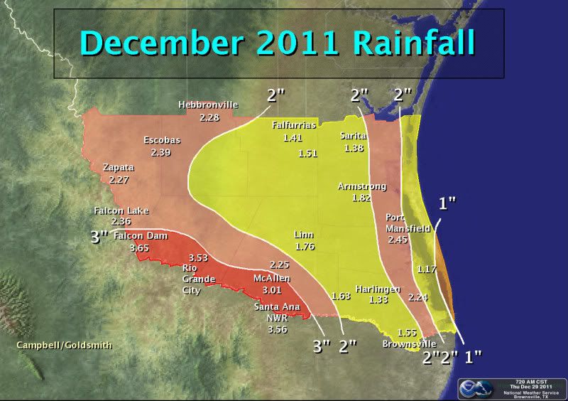
Never in a million year would I have bet on December being the wettest month of 2011 for Rio Grande City!! :lol:

Image
A series of mid and upper disturbances...combined with a low pressure trough along the Lower Coast...brought much needed rainfall to Deep South Texas and the Rio Grande Valley in December. Rainfall totals ranged from less than an inch right at the coast to well over 3 inches across southern Hidalgo...southern Starr and southern Zapata Counties. The heaviest rainfall occurred over a 2 day period...December 10th and 11th...where locations in western Hidalgo and eastern Starr Counties received nearly 50 percent of their total rainfall during the prior 14 months.
0 likes   
The following post is NOT an official forecast and should not be used as such. It is just the opinion of the poster and may or may not be backed by sound meteorological data. It is NOT endorsed by any professional institution including storm2k.org For Official Information please refer to the NHC and NWS products.

User avatar
South Texas Storms
Professional-Met
Professional-Met
Posts: 4224
Joined: Thu Jun 24, 2010 12:28 am
Location: Houston, TX

Re: C/S TX Weather: Seasonal with some rains

#1306 Postby South Texas Storms » Tue Jan 10, 2012 2:20 pm

Here is my latest weather article for Southeast Texas! Please check it out!
http://www.examiner.com/weather-in-hous ... -this-week
0 likes   

User avatar
Rgv20
S2K Supporter
S2K Supporter
Posts: 2466
Age: 38
Joined: Wed Jan 05, 2011 5:42 pm
Location: Edinburg/McAllen Tx

#1307 Postby Rgv20 » Sun Jan 15, 2012 3:27 pm

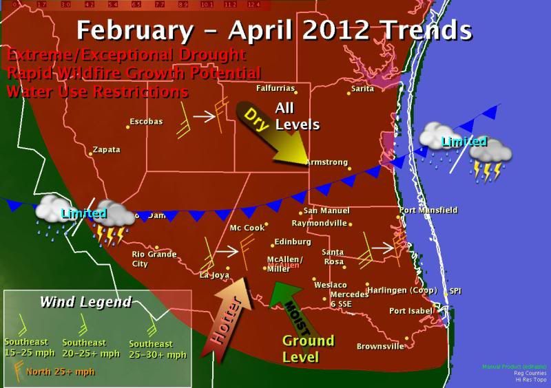
Looking at the loonnng range forecast the NWS in Brownsville think that it will be a warm and dry February thru April 2012 for Deep South Texas.

Image
The “Valley Wind Machine” will become active once again, with persistent south to southeast winds bringing warm and humid conditions. Occasional heat bursts will precede the relatively dry fronts; fronts will become less frequent by March and April, and changes will be to humidity levels and overnight temperatures for the most part.


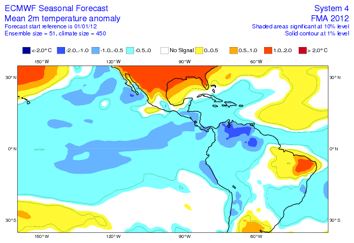
Taking a look at the recently issued European Seasonal Forecast for Feb thru April its forecasting for much of the southern US 2-3F above normal for the period.
Image


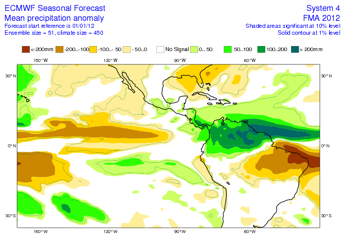
As far as the Rain forecast its calling for near normal values!! I have not seen near normal forecast Rainfall for a while! :lol:
Image
0 likes   
The following post is NOT an official forecast and should not be used as such. It is just the opinion of the poster and may or may not be backed by sound meteorological data. It is NOT endorsed by any professional institution including storm2k.org For Official Information please refer to the NHC and NWS products.

User avatar
Portastorm
Storm2k Moderator
Storm2k Moderator
Posts: 9914
Age: 63
Joined: Fri Jul 11, 2003 9:16 am
Location: Round Rock, TX
Contact:

Re: C/S TX Weather: Seasonal with some rains

#1308 Postby Portastorm » Mon Jan 16, 2012 9:45 am

As you know, I pay homage to King Euro every chance I get ... but I have been reading lately where even the Euro weeklies and long-range have been terrible lately. Don't know how much confidence I would have in this forecast.

But the good news is that La Nina appears to be taking a seat by this summer and possibly El Nino makes a welcomed (at least for us in Texas) return later this year.
0 likes   
Any forecasts under my name are to be taken with a grain of salt. Get your best forecasts from the National Weather Service and National Hurricane Center.

User avatar
wxman57
Moderator-Pro Met
Moderator-Pro Met
Posts: 22978
Age: 67
Joined: Sat Jun 21, 2003 8:06 pm
Location: Houston, TX (southwest)

Re: C/S TX Weather: Seasonal with some rains

#1309 Postby wxman57 » Mon Jan 16, 2012 11:21 am

Euro looks good to me, as I like warm temps.

Interesting MSLP projection, too. MUCH higher pressures across the Atlantic Basin than last hurricane season:
Image
0 likes   

User avatar
Portastorm
Storm2k Moderator
Storm2k Moderator
Posts: 9914
Age: 63
Joined: Fri Jul 11, 2003 9:16 am
Location: Round Rock, TX
Contact:

Re: C/S TX Weather: Seasonal with some rains

#1310 Postby Portastorm » Mon Jan 16, 2012 11:29 am

Now THAT is good news. I'm all for higher pressures in the Atlantic Basin during tropical season!

I wonder if the lack of winter this year for the lower 48 will have any effect on the water temps in and near the CONUS?
0 likes   
Any forecasts under my name are to be taken with a grain of salt. Get your best forecasts from the National Weather Service and National Hurricane Center.

User avatar
South Texas Storms
Professional-Met
Professional-Met
Posts: 4224
Joined: Thu Jun 24, 2010 12:28 am
Location: Houston, TX

Re: C/S TX Weather: Seasonal with some rains

#1311 Postby South Texas Storms » Mon Jan 16, 2012 1:35 pm

Does higher pressure in the Atlantic during tropical season mean less hurricanes?
0 likes   

User avatar
Portastorm
Storm2k Moderator
Storm2k Moderator
Posts: 9914
Age: 63
Joined: Fri Jul 11, 2003 9:16 am
Location: Round Rock, TX
Contact:

Re: C/S TX Weather: Seasonal with some rains

#1312 Postby Portastorm » Mon Jan 16, 2012 3:36 pm

South Texas Storms wrote:Does higher pressure in the Atlantic during tropical season mean less hurricanes?


In terms of those seasonal forecasts ... yes, absolutely ... or I should say it would mean less opportunity for tropical cyclone development.
0 likes   
Any forecasts under my name are to be taken with a grain of salt. Get your best forecasts from the National Weather Service and National Hurricane Center.

User avatar
Rgv20
S2K Supporter
S2K Supporter
Posts: 2466
Age: 38
Joined: Wed Jan 05, 2011 5:42 pm
Location: Edinburg/McAllen Tx

#1313 Postby Rgv20 » Tue Jan 17, 2012 12:19 am

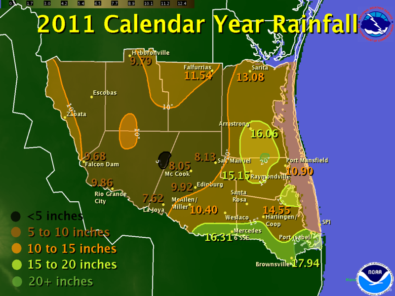
Taking a look back at the 2011 Rainfall amounts courtesy of the NWS in Brownsville, Its crazy to see how intense this drought has been.

Image


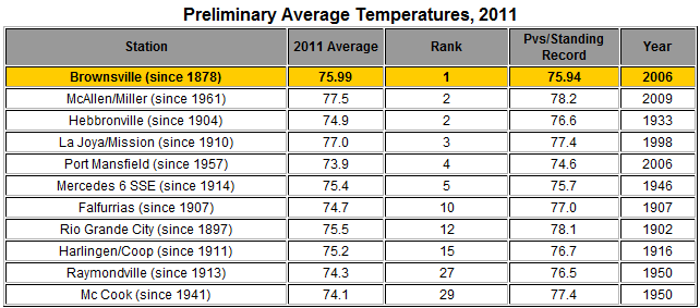
And of course dry conditions and warm temperatures go hand in hand....Brownsville set a new record in regards to the mean temperature. As you can see numerous cities ranked in the top 5.

Image
0 likes   
The following post is NOT an official forecast and should not be used as such. It is just the opinion of the poster and may or may not be backed by sound meteorological data. It is NOT endorsed by any professional institution including storm2k.org For Official Information please refer to the NHC and NWS products.

User avatar
Hurricaneman
Category 5
Category 5
Posts: 7351
Age: 45
Joined: Tue Aug 31, 2004 3:24 pm
Location: central florida

Re: C/S TX Weather: Seasonal with some rains

#1314 Postby Hurricaneman » Tue Jan 17, 2012 5:36 pm

I hope you guys in texas keep getting the rains you have had the last month or so. I hope your drought ends soon
0 likes   

User avatar
South Texas Storms
Professional-Met
Professional-Met
Posts: 4224
Joined: Thu Jun 24, 2010 12:28 am
Location: Houston, TX

Re: C/S TX Weather: Seasonal with some rains

#1315 Postby South Texas Storms » Tue Jan 17, 2012 9:22 pm

Hurricaneman wrote:I hope you guys in texas keep getting the rains you have had the last month or so. I hope your drought ends soon


Thanks Hurricaneman! We all hope so too! We have certainly been heading in the right direction lately and I hope it continues!
0 likes   

User avatar
Rgv20
S2K Supporter
S2K Supporter
Posts: 2466
Age: 38
Joined: Wed Jan 05, 2011 5:42 pm
Location: Edinburg/McAllen Tx

#1316 Postby Rgv20 » Tue Jan 24, 2012 1:11 am

Beneficial rains are in the cards for S/C Texas Tuesday Night! Hopefully I at least get a passing shower.. :)


SPECIAL WEATHER STATEMENT
NATIONAL WEATHER SERVICE AUSTIN/SAN ANTONIO TX
905 PM CST MON JAN 23 2012

TXZ171>173-183>194-202>209-217>225-228-241000-
LLANO-BURNET-WILLIAMSON-VAL VERDE-EDWARDS-REAL-KERR-BANDERA-
GILLESPIE-KENDALL-BLANCO-HAYS-TRAVIS-BASTROP-LEE-KINNEY-UVALDE-
MEDINA-BEXAR-COMAL-GUADALUPE-CALDWELL-FAYETTE-MAVERICK-ZAVALA-
FRIO-ATASCOSA-WILSON-KARNES-GONZALES-DE WITT-LAVACA-DIMMIT-
INCLUDING THE CITIES OF...LLANO...BURNET...GEORGETOWN...DEL RIO...
ROCKSPRINGS...LEAKEY...KERRVILLE...BANDERA...FREDERICKSBURG...
BOERNE...BLANCO...SAN MARCOS...AUSTIN...BASTROP...GIDDINGS...
BRACKETTVILLE...UVALDE...HONDO...SAN ANTONIO...NEW BRAUNFELS...
SEGUIN...LOCKHART...LA GRANGE...EAGLE PASS...CRYSTAL CITY...
PEARSALL...PLEASANTON...FLORESVILLE...KARNES CITY...GONZALES...
CUERO...HALLETTSVILLE...CARRIZO SPRINGS
905 PM CST MON JAN 23 2012

...STORM SYSTEM TO BRING BENEFICIAL RAIN AND SEVERE THUNDERSTORM
THREAT TO SOUTH CENTRAL TEXAS...

AN APPROACHING STORM SYSTEM ALOFT AND AN ASSOCIATED COLD FRONT WILL
AFFECT SOUTH CENTRAL TEXAS BEGINNING TUESDAY AND CONTINUING THROUGH
WEDNESDAY. THUNDERSTORMS WILL BEGIN ACROSS THE WESTERN HILL COUNTRY
AND EDWARDS PLATEAU LATE TUESDAY...THEN EXPAND AND SPREAD EAST WITH
TIME AFFECTING THE INTERSTATE 35 CORRIDOR EARLY WEDNESDAY MORNING.
STORMS ARE FORECAST TO EXIT INTO EAST TEXAS.

SOME OF THESE STORMS MAY BECOME SEVERE TUESDAY NIGHT. THE MAIN
THREAT ACROSS WESTERN PORTIONS OF SOUTH CENTRAL TEXAS WILL BE
LARGE HAIL. ACROSS EASTERN PORTIONS OF THE AREA...THE MAIN THREAT
WILL BE FROM DAMAGING WINDS. IN ADDITION...LOCALLY HEAVY RAINFALL
IS POSSIBLE ALONG AND EAST OF HIGHWAY 281.

GO TO http://WWW.SRH.NOAA.GOV/EWX FOR THE LATEST INFORMATION...FORECASTS
AND WARNINGS.

$$


SPW from the NWS in Corpus.

SPECIAL WEATHER STATEMENT
NATIONAL WEATHER SERVICE CORPUS CHRISTI TX
325 PM CST MON JAN 23 2012

TXZ229>234-239>247-240700-
LA SALLE-MCMULLEN-LIVE OAK-BEE-GOLIAD-VICTORIA-WEBB-DUVAL-
JIM WELLS-KLEBERG-NUECES-SAN PATRICIO-ARANSAS-REFUGIO-CALHOUN-
INCLUDING THE CITIES OF...COTULLA...CALLIHAM...CROSS...
LOMA ALTA...TILDEN...GEORGE WEST...THREE RIVERS...BEEVILLE...
GOLIAD...VICTORIA...LAREDO...FREER...BENAVIDES...SAN DIEGO...
ALICE...ORANGE GROVE...KINGSVILLE...CORPUS CHRISTI...PORTLAND...
INGLESIDE...ARANSAS PASS...SINTON...MATHIS...ROCKPORT...REFUGIO...
WOODSBORO...PORT LAVACA
325 PM CST MON JAN 23 2012

...POTENTIAL FOR STRONG TO SEVERE THUNDERSTORMS LATE TUESDAY
NIGHT THROUGH EARLY WEDNESDAY AFTERNOON...
...RAIN CHANCES INCREASE TUESDAY THROUGH WEDNESDAY...

A POTENT UPPER LEVEL DISTURBANCE WILL APPROACH SOUTH TEXAS ON
TUESDAY. THE COLD FRONT WHICH MOVED THROUGH SOUTH TEXAS MONDAY
MORNING WILL BEGIN TO MOVE NORTH OVERNIGHT AS A WARM FRONT...AND
MOVE NORTH OF THE AREA BY LATE TUESDAY AFTERNOON. LIFT ALONG AND
AHEAD OF THE BOUNDARY WILL PROVIDE A SLIGHT CHANCE FOR SHOWERS OR
RAIN OVERNIGHT TONIGHT INTO EARLY TUESDAY MORNING.

RAIN CHANCES WILL BEGIN TO INCREASE TUESDAY AS THE FRONT MOVES
NORTH...ATMOSPHERIC INSTABILITY INCREASES...AND A WEAK TO MODERATE
UPPER LEVEL JET STREAK MOVES TOWARD SOUTH TEXAS. THIS
COMBINATION WILL PROVIDE A CHANCE FOR SHOWERS ON TUESDAY...WITH
THUNDERSTORMS POSSIBLE DURING THE AFTERNOON MAINLY EAST OF HIGHWAY
281. A FEW STRONG STORMS WILL BE POSSIBLE TUESDAY
AFTERNOON...PRODUCING WIND GUSTS TO 50 MPH ALONG WITH SMALL HAIL.

BY TUESDAY NIGHT...THE DYNAMICS OF THE UPPER LEVEL STORM SYSTEM
WILL REALLY BEGIN TO IMPACT SOUTH TEXAS...AIDED IN PART BY
MODERATE TO STRONG FORCING NEAR THE SURFACE. SHOWERS AND
THUNDERSTORMS ARE EXPECTED TO DEVELOP NORTH AND WEST OF THE AREA
DURING LATE EVENING AND OVERNIGHT HOURS...WITH THE ACTIVITY
EXPECTED TO MOVE EAST-SOUTHEAST THROUGH WEDNESDAY MORNING.

AT THIS TIME...THE MOST LIKELY PERIOD FOR THUNDERSTORM ACTIVITY
WILL OCCUR AFTER MIDNIGHT TUESDAY NIGHT AND CONTINUE POSSIBLY THROUGH
EARLY WEDNESDAY AFTERNOON...ROUGHLY BETWEEN 2 AM AND
NOON...INITIALLY STARTING OVER THE NORTHERN BRUSH COUNTRY AND RIO
GRANDE PLAINS. SOME OF THE THUNDERSTORMS ARE EXPECTED TO BE STRONG
OR EVEN SEVERE. THE MAIN THREAT FOR SEVERE THUNDERSTORMS WILL BE NEAR
AND NORTH OF A CORPUS CHRISTI TO ALICE TO ENCINAL LINE...WITH THE
MAIN CONCERN BEING STRONG STRAIGHT-LINE WINDS...AND POSSIBLY A
TORNADO OR TWO. WHILE THE CONCERN FOR SEVERE WEATHER IS LOWER
SOUTH OF THIS LINE...ISOLATED SEVERE THUNDERSTORMS COULD NOT BE
RULED OUT.

AS THE SYSTEM BEGINS TO MOVE EAST WEDNESDAY AFTERNOON...RAIN
CHANCES WILL DIMINISH FROM WEST TO EAST...AS A FRONTAL BOUNDARY
MOVES INTO SOUTH TEXAS AND BRINGS DRIER AND COOLER AIR. RAINFALL
AMOUNTS TUESDAY THROUGH WEDNESDAY EVENING WILL AVERAGE FROM 1/4
INCH OR LESS OVER THE RIO GRANDE NEAR LAREDO...1/2 INCH OR MORE
NEAR AND NORTH OF A COTULLA TO CORPUS CHRISTI LINE...AND 1 INCH OR
MORE NEAR AND EAST OF A ROCKPORT TO PETTUS LINE.

RESIDENTS...ESPECIALLY EMERGENCY MANAGERS AND LAW ENFORCEMENT...
SHOULD CONTINUE TO MONITOR THE LATEST FORECASTS CONCERNING THIS
UPCOMING WEATHER EVENT.

$$

GW
0 likes   
The following post is NOT an official forecast and should not be used as such. It is just the opinion of the poster and may or may not be backed by sound meteorological data. It is NOT endorsed by any professional institution including storm2k.org For Official Information please refer to the NHC and NWS products.

User avatar
Portastorm
Storm2k Moderator
Storm2k Moderator
Posts: 9914
Age: 63
Joined: Fri Jul 11, 2003 9:16 am
Location: Round Rock, TX
Contact:

#1317 Postby Portastorm » Tue Jan 24, 2012 8:14 am

HPC suggests 2-3 inches of rain for the Austin metro area in the next 36 hours ... hope it verifies!
0 likes   
Any forecasts under my name are to be taken with a grain of salt. Get your best forecasts from the National Weather Service and National Hurricane Center.

User avatar
cycloneye
Admin
Admin
Posts: 145294
Age: 68
Joined: Thu Oct 10, 2002 10:54 am
Location: San Juan, Puerto Rico

Re: C/S TX Weather: Seasonal with some rains

#1318 Postby cycloneye » Tue Jan 24, 2012 2:32 pm

Let's hope nothing of severe status occurs with this needed precipitation in that state.

Image
0 likes   
Visit the Caribbean-Central America Weather Thread where you can find at first post web cams,radars
and observations from Caribbean basin members Click Here

User avatar
Ntxw
Storm2k Moderator
Storm2k Moderator
Posts: 22784
Joined: Wed Oct 21, 2009 6:34 pm
Location: DFW, Texas

#1319 Postby Ntxw » Tue Jan 24, 2012 7:21 pm

Lots of training going on along I-35, some of the rain just south of the metroplex is clocking in at 2-3 inches per hour. Not bad for January. Hopefully more will build south into the hill country as the ULL slowly progresses east. The trend lately is slow progression and further south of the low. Central Texas should get lots!

Next 12 hour totals depicted by the HRRR

Image

Uploaded with ImageShack.us
0 likes   
The above post and any post by Ntxw is NOT an official forecast and should not be used as such. It is just the opinion of the poster and may or may not be backed by sound meteorological data. It is NOT endorsed by any professional institution including Storm2k. For official information, please refer to NWS products.

  Help support Storm2K!
Help Support Storm2K

User avatar
Rgv20
S2K Supporter
S2K Supporter
Posts: 2466
Age: 38
Joined: Wed Jan 05, 2011 5:42 pm
Location: Edinburg/McAllen Tx

#1320 Postby Rgv20 » Wed Jan 25, 2012 12:53 am

Cant remember when was the last time we had a Flood Watch in Texas!

FLOOD WATCH
NATIONAL WEATHER SERVICE FORT WORTH TX
936 PM CST TUE JAN 24 2012

TXZ091>095-101>107-116>123-130>135-141>148-156>162-174-175-251100-
/O.NEW.KFWD.FF.A.0001.120125T0336Z-120125T1800Z/
/00000.0.ER.000000T0000Z.000000T0000Z.000000T0000Z.OO/
MONTAGUE-COOKE-GRAYSON-FANNIN-LAMAR-JACK-WISE-DENTON-COLLIN-HUNT-
DELTA-HOPKINS-PALO PINTO-PARKER-TARRANT-DALLAS-ROCKWALL-KAUFMAN-
VAN ZANDT-RAINS-ERATH-HOOD-SOMERVELL-JOHNSON-ELLIS-HENDERSON-
COMANCHE-MILLS-HAMILTON-BOSQUE-HILL-NAVARRO-FREESTONE-ANDERSON-
LAMPASAS-CORYELL-BELL-MCLENNAN-FALLS-LIMESTONE-LEON-MILAM-
ROBERTSON-
936 PM CST TUE JAN 24 2012

...FLASH FLOOD WATCH IN EFFECT THROUGH WEDNESDAY MORNING...

THE NATIONAL WEATHER SERVICE IN FORT WORTH HAS ISSUED A

* FLASH FLOOD WATCH FOR ALL OF NORTH TEXAS ALONG AND EAST OF A
LINE FROM JACKSBORO TO COMANCHE.

* THROUGH NOON WEDNESDAY.

* HEAVY RAIN OVERNIGHT IS EXPECTED TO ADD AN ADDITIONAL TWO TO
FOUR INCHES TO THE RAIN THAT HAS ALREADY FALLEN.

* UNDERPASSES...LOW WATER CROSSINGS...CREEKS AND DITCHES...AND
MANY STREAMS AND RIVERS MAY SEE RAPID WATER LEVEL RISES. AT
NIGHT ESPECIALLY IT IS DIFFICULT TO SEE WATER OVER ROADS...USE
EXTREME CAUTION.

PRECAUTIONARY/PREPAREDNESS ACTIONS...

A FLASH FLOOD WATCH MEANS THAT CONDITIONS ARE FAVORABLE FOR HEAVY
RAIN WHICH MAY LEAD TO FLASH FLOODING. YOU SHOULD MONITOR THE
LATEST FORECASTS FROM THE NATIONAL WEATHER SERVICE AND BE
PREPARED TO TAKE ACTION SHOULD FLASH FLOOD WARNINGS BE ISSUED FOR
YOUR AREA.

&&

$$
0 likes   
The following post is NOT an official forecast and should not be used as such. It is just the opinion of the poster and may or may not be backed by sound meteorological data. It is NOT endorsed by any professional institution including storm2k.org For Official Information please refer to the NHC and NWS products.


Return to “USA & Caribbean Weather”

Who is online

Users browsing this forum: 869MB, txtwister78 and 16 guests