
Models have been pretty consistent with Monday's system, looks like a real blizzard in the panhandles and plenty of rain for those of us who needs it. Christmas could be desert like dry or tundra like wet.
Texas Winter 2011-2012...
Moderator: S2k Moderators
Forum rules
 The posts in this forum are NOT official forecast and should not be used as such. They are just the opinion of the poster and may or may not be backed by sound meteorological data. They are NOT endorsed by any professional institution or STORM2K.

The posts in this forum are NOT official forecast and should not be used as such. They are just the opinion of the poster and may or may not be backed by sound meteorological data. They are NOT endorsed by any professional institution or STORM2K.
I was just going through the 2009 Christmas eve storm in the 09-10 winter thread. Boy was that fun lol. The flip flopping day after day from about the 16th forward was crazy. Cold no cold, heat wave, storm no storm, blizzard or severe weather from a landcane jesus  good times. We were spinning Portastorm every which way until he caved in and gave it to us! Only one who stood firm was Msstguy with his outrageous snow totals (which came to fruition). We were all certain nothing special would happen until the night before the low just kept plowing southeast instead of making that hard NE turn.
Models have been pretty consistent with Monday's system, looks like a real blizzard in the panhandles and plenty of rain for those of us who needs it. Christmas could be desert like dry or tundra like wet.
Models have been pretty consistent with Monday's system, looks like a real blizzard in the panhandles and plenty of rain for those of us who needs it. Christmas could be desert like dry or tundra like wet.
0 likes
The above post and any post by Ntxw is NOT an official forecast and should not be used as such. It is just the opinion of the poster and may or may not be backed by sound meteorological data. It is NOT endorsed by any professional institution including Storm2k. For official information, please refer to NWS products.
Help support Storm2K!
-
arizona_sooner
- Tropical Depression

- Posts: 64
- Joined: Sat Jan 09, 2010 10:09 am
- Location: Peoria, AZ
Re: Texas Winter 2011-2012...
This has truly been an odd "La Nina" year.
I was up in the interior northwest (south-central Washington) over the post-Thanksgiving period and early December. We were stuck in a strong inversion with fog most days and temps between 15-25F most of the time. No precip, except for some Columbia River-effect snow flurries occasionally.
This past week I have been in northwest Ohio, and for much of the time, it was warmer here than at my home in Glendale, AZ. Today, however, was a more normal winter day, as it snowed lightly most all of the day with temps in the low 30s. Accumulations were on the range of half an inch to an inch on grassy or elevated surfaces.
And back home in Arizona, we have had measurable rain on 11 or 12 days over the past month and a half with rather cool temps. The rain has not been a huge amount but it's been fairly regular, which is nice for AZ.
Maybe the whole country east of the Rockies will have a cold period sometime this winter but I certainly would not expect any record cold like we have seen in recent years. I think this will be a rather blah winter (which will be good for heating bills!).
0 likes

Re:
Ntxw wrote:I was just going through the 2009 Christmas eve storm in the 09-10 winter thread. Boy was that fun lol. The flip flopping day after day from about the 16th forward was crazy. Cold no cold, heat wave, storm no storm, blizzard or severe weather from a landcane jesus
Models have been pretty consistent with Monday's system, looks like a real blizzard in the panhandles and plenty of rain for those of us who needs it. Christmas could be desert like dry or tundra like wet.
That was a blast. If you ever want to waste a good 30 minutes, just go back and look at some previous threads. I can't wait 'til the first real winter storm this year (there will be one.) I'll be ready to stay up all night with some hot chocolate and all the computer models my eyes can handle.
0 likes


Re: Texas Winter 2011-2012...
Is there any chance of the snow band moving deeper to the southeast?
0 likes
-
Portastorm

- Storm2k Moderator

- Posts: 9954
- Age: 63
- Joined: Fri Jul 11, 2003 9:16 am
- Location: Round Rock, TX
- Contact:
Re:
Ntxw wrote:I was just going through the 2009 Christmas eve storm in the 09-10 winter thread. Boy was that fun lol. The flip flopping day after day from about the 16th forward was crazy. Cold no cold, heat wave, storm no storm, blizzard or severe weather from a landcane jesus
Models have been pretty consistent with Monday's system, looks like a real blizzard in the panhandles and plenty of rain for those of us who needs it. Christmas could be desert like dry or tundra like wet.
Haa! You guys did drive me crazy.
I sure hope we have a few of those this winter. Good times.
0 likes
Any forecasts under my name are to be taken with a grain of salt. Get your best forecasts from the National Weather Service and National Hurricane Center.
-
Rgv20

- S2K Supporter

- Posts: 2466
- Age: 39
- Joined: Wed Jan 05, 2011 5:42 pm
- Location: Edinburg/McAllen Tx
0zNAM still on schedule on a pretty potent winter storm for the Northern Panhandle....Its forecasting 12''+ of snow and rather windy conditions too. Would not be surprised if the NWS in Amarillo hoist up a Blizzard Watch..
0zNAM Total forecast snowfall ending on Tuesday evening.
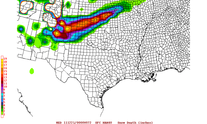
0zNAM Total forecast snowfall ending on Tuesday evening.
0 likes
The following post is NOT an official forecast and should not be used as such. It is just the opinion of the poster and may or may not be backed by sound meteorological data. It is NOT endorsed by any professional institution including storm2k.org For Official Information please refer to the NHC and NWS products.
-
weatherdude1108
- Category 5

- Posts: 4228
- Joined: Tue Dec 13, 2011 1:04 pm
- Location: Northwest Austin/Cedar Park, TX
Re: Re:
Portastorm wrote:weatherdude1108 wrote:I have been reading this guy Bob Rose's weather blogs for several years. He has a weather blog for LCRA. He apparently has been getting questions on the rains Central Texas has had during November and December. At the same time, the Pacific NW has had their driest December in years, unheard of in a La Nina. He also mentions the forecast for Christmas has changed just since yesterday.
http://www.lcra.org/water/conditions/we ... olumn.html
The above post and any post by Weatherdude1108 is NOT an official forecast and should not be used as such. It is just the opinion of the poster and may or may not be backed by sound meteorological data. It is NOT endorsed by any professional institution including storm2k.org. For official information, please refer to NWS products.
Thanks for posting ... Bob is a friend of mine and a very good forecaster. He did a nice job on this writeup. His blog usually has some great information and he writes in an educational
style.
Glad to do it. You know him? Cool! He is very good at forecasting. I emailed him in August when we were suffering through drought and heat and asked him what his thoughts were on the tropics. He emailed back that same day with statistics and the history and his thoughts on it. Seems very cool and knowledgeable!
0 likes
The preceding post is NOT an official forecast, and should not be used as such. It is only the opinion of the poster and may or may not be backed by sound meteorological data. It is NOT endorsed by any professional institution including storm2k.org. For Official Information please refer to the NHC and NWS products.
Man this AO+ is ridiculous. I know it's tough in these parts of Texas for snow but the country as a whole is starving for it. It's green/brown all the way up to Minnesota and it's almost Christmas! Henry Margusity at Accuweather is just painfully withering away desperate for an east coast blizzard lol. Many up that way I'm sure are happy to just see a flurry. Hopefully the PNA going even more positive might be enough to overwhelm the zonal pattern.
Tonight's models have a coolish Christmas. Not a lot of moisture around anywhere as of the runs. Transient shots of modified Canadian air every now and then.
Can you recall a lesser snow cover outside of the mountains heading in the winter solstice??

Uploaded with ImageShack.us
Tonight's models have a coolish Christmas. Not a lot of moisture around anywhere as of the runs. Transient shots of modified Canadian air every now and then.
Can you recall a lesser snow cover outside of the mountains heading in the winter solstice??

Uploaded with ImageShack.us
0 likes
The above post and any post by Ntxw is NOT an official forecast and should not be used as such. It is just the opinion of the poster and may or may not be backed by sound meteorological data. It is NOT endorsed by any professional institution including Storm2k. For official information, please refer to NWS products.
Help support Storm2K!
Help support Storm2K!
-
Rgv20
- S2K Supporter
- Posts: 2466
- Age: 39
- Joined: Wed Jan 05, 2011 5:42 pm
- Location: Edinburg/McAllen Tx
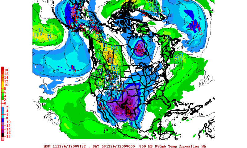
The 0zECMWF has some pretty impressive 850mb temperatures departures for the holiday weekend and early next week. Hopefully we can squeeze out some cool weather for the Christmas holiday
0zECMWF forecast 850mb Temperature Anomalies for 12-26-2011 Monday evening.
0 likes
The following post is NOT an official forecast and should not be used as such. It is just the opinion of the poster and may or may not be backed by sound meteorological data. It is NOT endorsed by any professional institution including storm2k.org For Official Information please refer to the NHC and NWS products.
-
HockeyTx82
- S2K Supporter
- Posts: 2774
- Joined: Tue Oct 27, 2009 11:17 am
- Location: Ponder, TX
Re: Texas Winter 2011-2012...
FXUS64 KFWD 181133 AAA
AFDFWD
AREA FORECAST DISCUSSION...UPDATED
NATIONAL WEATHER SERVICE FORT WORTH TX
533 AM CST SUN DEC 18 2011
.AVIATION...
/12Z TAFS/
MID LEVEL CLOUDINESS ON THE INCREASE THIS MORNING AHEAD OF STRONG
STORM SYSTEM OVER THE SOUTHWEST US. VFR CIGS EXPECTED TO PERSIST
THROUGH THE TAF PERIOD WITH A GRADUAL LOWER LATER TONIGHT. IT
APPEARS THAT THE DRY LOWER LEVELS WILL LINGER THROUGH LATE TONIGHT
BEFORE RAPID SATURATION OCCURS. MVFR CIGS EXPECTED BY MID MORNING
MONDAY WITH PRECIP DEVELOPING AND MOVING EAST. NUMEROUS SHOWERS
AND THUNDERSTORMS EXPECTED BY EARLY MONDAY AFTERNOON AND THESE
WILL BE ADDRESSED IN THE NEXT ISSUANCE. RAIN AND THUNDERSTORMS
LIKELY TO PERSIST INTO THE EVENING HOURS WITH TEMPO IFR CONDITIONS
THROUGHOUT THE AFTERNOON AND EVENING.
DUNN
&&
.PREV DISCUSSION... /ISSUED 429 AM CST SUN DEC 18 2011/
LARGE UPPER LEVEL LOW NEAR SAN DIEGO WILL BEGIN TO HEAD EAST
DURING THE DAY AND WILL TRACK ACROSS THE TEXAS PANHANDLE MONDAY
EVENING BEFORE CURLING NORTH INTO THE CENTRAL PLAINS ON TUESDAY.
THIS WILL BE A POWERFUL STORM SYSTEM...BRINGING HEAVY SNOW FROM
THE PANHANDLE INTO KANSAS...AND A ROUND OF POSSIBLY SEVERE
THUNDERSTORMS WITH THE POTENTIAL FOR TORNADOES IN OUR AREA.
FOR TODAY...MID LEVEL CLOUDS WILL BE INCREASING ACROSS THE REGION
FROM THE SOUTHWEST AS ISENTROPIC LIFT BEGINS TO ORGANIZE. HIGHS
WILL BE NEAR 60 DESPITE THE LACK OF SUNSHINE AS SOUTHERLY WINDS
BRING WARMER AIR NORTHWARD. SATURATION OF THE LOW LEVELS OCCURS
TONIGHT...WITH SOME WEAK SHOWERS BY DAYBREAK MAINLY WEST OF I-35.
WIND SPEEDS THROUGH THE ENTIRE COLUMN INCREASE DRAMATICALLY ON
MONDAY AS THE UPPER LOW EDGES CLOSER. VERY HIGH VALUES OF SHEAR
ARE EXPECTED WITH 0-6KM SHEAR OF 55KT...0-1KM SHEAR OF 35KT AND
0-3KM HELICITY EXCEEDING 500M2/S2. 850MB WINDS ARE ALSO DUE
SOUTHERLY...WHICH IS MORE BACKED THAN NORMAL. THIS SHOULD ALLOW
FOR EXCELLENT TRANSPORT OF MOISTURE/WARM AIR NORTHWARD AND A RAPID
MODIFICATION OF OUR AIR MASS DURING THE DAY. THE NAM/HI-RES WRF
ARE FAVORED FOR INSTABILITY FORECASTS AS THEIR SURFACE TEMPS
APPEAR MOST REASONABLE. ALTHOUGH CAPE LIKELY WILL NOT EXCEED 1000
J/KG...IT SHOULD BE NOTED THAT 100-300J/KG OF THE TOTAL CAPE IS
LOCATED BELOW 3KM DUE TO LFC OCCURRING WITHIN 1KM OF THE GROUND.
THIS SYSTEM HAS SOME SIMILARITIES TO THE DECEMBER 29 2006 SYSTEM
THAT PRODUCED 2 DOZEN TORNADOES OVER OUR AREA. THE 2006 SYSTEM WAS
A LITTLE BIT STRONGER AT 500 MB...TRACKED FARTHER SOUTH...AND THE
SURFACE LOW AND WARM FRONT WERE ALSO FARTHER SOUTH. I DONT EXPECT
A SEVERE WEATHER EVENT OF THAT CALIBER THIS TIME AROUND...BUT
THERE ARE ENOUGH SIMILARITIES THAT IT RAISES THE CONCERN FOR
TORNADOES DESPITE MANY MODEL FORECASTS SAYING THE INSTABILITY WILL
BE LIMITED. THE MODELS IN 2006 ALSO UNDERPLAYED THE INSTABILITY
AND THIS TIME WE WILL BE A LITTLE MORE WARY. SINCE IT IS DECEMBER
AND SEVERE WEATHER IS NOT USUALLY ON PEOPLES MIND...WE ARE GOING
TO ADVERTISE THE THREAT NOW DESPITE LOWER THAN NORMAL CONFIDENCE.
THE 2006 CASE HAD NUMEROUS DISCRETE SUPERCELLS AHEAD OF THE COLD
FRONT...AND I DONT EXPECT THAT THIS TIME AROUND. EXPECT MOST OF
THE CONVECTION TO DEVELOP ALONG A NORTH-SOUTH ORIENTED COLD FRONT
WHICH SHOULD MOVE INTO THE WESTERN CWA BY 3 PM. A SOLID SQUALL
LINE SHOULD DEVELOP ALONG THE FRONT...AND REACH THE I-35 CORRIDOR
AROUND 6PM MONDAY. STORM MOTION AT 45KT MEANS ANY STORM WILL HAVE
THE POTENTIAL FOR WIND DAMAGE DUE TO DOWNWARD MOMENTUM TRANSPORT
OF 55KT 850MB WINDS. TORNADO THREAT WILL BE LIMITED BY THE STORM
MODE BEING MAINLY LINEAR...BUT WILL BE POSSIBLE DUE TO THE HIGH
LOW LEVEL SHEAR AND CAPE. TORNADO THREAT IS HIGHEST SOUTH OF A
GOLDTHWAITE...HILLSBORO...ATHENS LINE WHERE INSTABILITY PARAMETERS
ARE GREATEST. SQUALL LINE SHOULD CLEAR THE CWA BY 2 AM TUESDAY.
WINDY AND COLDER CONDITIONS ARE EXPECTED ON TUESDAY WITH SOME WRAP
AROUND CLOUDS AFFECTING THE NORTHERN CWA. SKIES CLEAR TUESDAY
NIGHT...AND WITH THE SURFACE HIGH BUILDING IN...IT SHOULD BE BELOW
FREEZING EVERYWHERE. SUNNY AND COOL WEATHER IS EXPECTED WEDNESDAY
BUT MORE CLOUDS WILL ARRIVE THURSDAY AS THE NEXT SHORTWAVE MOVES
THROUGH. MOISTURE IS RATHER LIMITED...BUT THERE SHOULD BE ENOUGH
FOR SOME RAIN IN THE SOUTHEAST ZONES. ANOTHER COLD FRONT ARRIVES
THURSDAY...WITH COOL AND FAIR WEATHER EXPECTED INTO SATURDAY.
TR.92
&&
0 likes
-
Rgv20
- S2K Supporter
- Posts: 2466
- Age: 39
- Joined: Wed Jan 05, 2011 5:42 pm
- Location: Edinburg/McAllen Tx
Looks like some dangerous winter weather for parts of the Texas panhandle 
Blizzard Watch
URGENT - WINTER WEATHER MESSAGE
NATIONAL WEATHER SERVICE AMARILLO TX
450 AM CST SUN DEC 18 2011
...MODERATE TO HEAVY SNOW AND STRONG NORTH WINDS TO IMPACT THE
TEXAS AND OKLAHOMA PANHANDLES MONDAY INTO TUESDAY MORNING...
.A POTENT LOW PRESSURE SYSTEM OVER THE SOUTHERN CALIFORNIA COAST
WILL WORK SLOWLY EAST ACROSS SOUTHERN ARIZONA TODAY...AND INTO FAR
SOUTHERN NEW MEXICO BY MONDAY MORNING. THIS STORM SYSTEM WILL THEN
LIFT NORTHEAST ACROSS THE EXTREME SOUTHERN TEXAS PANHANDLE INTO
WESTERN OKLAHOMA BY TUESDAY MORNING. THE INTENSE LOW PRESSURE SYSTEM
WILL TEAM WITH A STRONG COLD FRONT THAT WILL PUSH SOUTH THROUGH THE
PANHANDLES ON MONDAY TO BRING MODERATE TO HEAVY SNOW TO THE OKLAHOMA
PANHANDLE AND ALL BUT THE FAR SOUTHEAST TEXAS PANHANDLE. IN
ADDITION...STRONG NORTH WINDS BEHIND THE COLD FRONT WILL LEAD TO
BLOWING AND DRIFTING SNOW AND VERY POOR VISIBILITIES...RESULTING IN
BLIZZARD CONDITIONS OVER MUCH OF THE AREA.
OKZ001>003-TXZ001>008-011-012-016-017-181900-
/O.CAN.KAMA.WS.A.0004.111219T1200Z-111220T1800Z/
/O.NEW.KAMA.BZ.A.0001.111219T1200Z-111220T1800Z/
CIMARRON-TEXAS-BEAVER-DALLAM-SHERMAN-HANSFORD-OCHILTREE-LIPSCOMB-
HARTLEY-MOORE-HUTCHINSON-OLDHAM-POTTER-DEAF SMITH-RANDALL-
INCLUDING THE CITIES OF...BOISE CITY...KEYES...GUYMON...BEAVER...
FORGAN...DALHART...STRATFORD...SPEARMAN...GRUVER...PERRYTON...
BOOKER...HIGGINS...FOLLETT...HARTLEY...CHANNING...DUMAS...
BORGER...VEGA...AMARILLO...HEREFORD...CANYON
450 AM CST SUN DEC 18 2011
...BLIZZARD WATCH IN EFFECT FROM MONDAY MORNING THROUGH TUESDAY
MORNING...
...WINTER STORM WATCH IS CANCELLED...
THE NATIONAL WEATHER SERVICE IN AMARILLO HAS ISSUED A BLIZZARD
WATCH...WHICH IS IN EFFECT FROM MONDAY MORNING THROUGH TUESDAY
MORNING. THE WINTER STORM WATCH HAS BEEN CANCELLED.
* EVENT...HEAVY SNOW AND STRONG NORTH WINDS WILL IMPACT THE OKLAHOMA
PANHANDLE...AND NORTHERN AND WESTERN TEXAS PANHANDLE...MONDAY INTO
TUESDAY MORNING. STORM TOTAL SNOWFALL ACCUMULATIONS OF 6 TO 15
INCHES ARE LIKELY. THE HIGHEST TOTALS...IN THE 12 TO 15 INCH
RANGE...WILL BE FOUND ACROSS THE OKLAHOMA PANHANDLE AND NORTHWEST
TEXAS PANHANDLE. NORTH WINDS WILL INCREASE TO 25 TO 35 MPH WITH
GUSTS UP TO 50 MPH BEHIND THE COLD FRONT ON MONDAY...PRODUCING
BLOWING AND DRIFTING SNOW AND PERIODS OF WHITEOUT CONDITIONS.
* TIMING...RAIN WILL TRANSITION TO SNOW FROM NORTHWEST TO SOUTHEAST
ON MONDAY...WITH ALL SNOW EXPECTED BY EARLY MONDAY EVENING. THE
SNOW WILL CONTINUE MONDAY NIGHT...BEFORE ENDING FROM SOUTHWEST TO
NORTHEAST TUESDAY MORNING. THE STRONG NORTH WINDS WILL DEVELOP
MONDAY AND CONTINUE THROUGH MONDAY NIGHT...BEFORE DIMINISHING
TUESDAY MORNING.
* IMPACTS...ROADS WILL BECOME ICY AND SNOW PACKED...LEADING TO
HAZARDOUS TRAVEL CONDITIONS. BLOWING SNOW PRODUCED BY THE STRONG
NORTH WINDS WILL LEAD TO PERIODS OF ZERO VISIBILITIES AND WHITEOUT
CONDITIONS.
PRECAUTIONARY/PREPAREDNESS ACTIONS...
A BLIZZARD WATCH MEANS THERE IS A POTENTIAL FOR FALLING AND...OR
BLOWING SNOW WITH STRONG WINDS AND EXTREMELY POOR VISIBILITIES.
THIS CAN LEAD TO WHITEOUT CONDITIONS AND MAKE TRAVEL VERY
DANGEROUS.
&&
$$
0 likes
The following post is NOT an official forecast and should not be used as such. It is just the opinion of the poster and may or may not be backed by sound meteorological data. It is NOT endorsed by any professional institution including storm2k.org For Official Information please refer to the NHC and NWS products.
This morning's model runs continue to advertise a chilly Christmas weekend for Texas. That has been consistent so hopefully we can get it to holiday mode weather wise.
ECMWF continues to advertise a deep trough (full lattitude anyone) give or take shortly there after since a couple of nights ago. Of course long range always shows cold stuff but we'll have to wait and see.

Uploaded with ImageShack.us

Uploaded with ImageShack.us
^ incase anyone is wondering, direct translation of the second euro image has snow/precip from the upper rio grand valley heading northeast into central Texas and beyond day after Christmas potentially.
0 likes
The above post and any post by Ntxw is NOT an official forecast and should not be used as such. It is just the opinion of the poster and may or may not be backed by sound meteorological data. It is NOT endorsed by any professional institution including Storm2k. For official information, please refer to NWS products.
Help support Storm2K!
Help support Storm2K!
it looks like a true blizzard bomb from ne new mexico/ se colorado throught the panhandles and on into kansas. i would love to be able to observe this one. if we have any storm2ker (s) lucky enough to be in the strike zone (i recognize it's pretty rural) stay safe and keep us updated. those open plains lend themselves to enormous drift growth. that open territory isn't just a good chase zone for severe weather, it's perfect for a blizzard as well. what a dynamic bomb we have in the making. cool!
0 likes
Re:
psyclone wrote:it looks like a true blizzard bomb from ne new mexico/ se colorado throught the panhandles and on into kansas. i would love to be able to observe this one. if we have any storm2ker (s) lucky enough to be in the strike zone (i recognize it's pretty rural) stay safe and keep us updated. those open plains lend themselves to enormous drift growth. that open territory isn't just a good chase zone for severe weather, it's perfect for a blizzard as well. what a dynamic bomb we have in the making. cool!
If I wasn't short on money and if it wasn't Christmas time, I would have probably drove up there. It seems like these storms always have bad timing.
0 likes
-
Rgv20
- S2K Supporter
- Posts: 2466
- Age: 39
- Joined: Wed Jan 05, 2011 5:42 pm
- Location: Edinburg/McAllen Tx
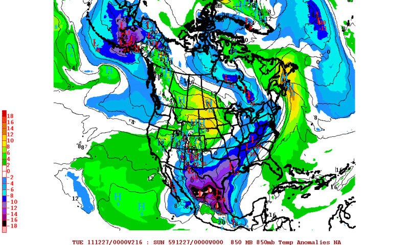
The Euro has had a couple of interesting runs regarding some potentially colder weather for Texas on the Christmas weekend and early next week.
12zECMWF Forecast 850mb Temperature Anomalies for 12-26-11 Monday Morning. It shows 850 Temperatures in the range of -14 to -18C below normal!
I just took a quick look at the 12zJMA and it coincides very well with the Euro on the 500mb pattern for early next week.
12zECMWF Forecast 850mb Temperature Anomalies for 12-26-11 Monday Morning. It shows 850 Temperatures in the range of -14 to -18C below normal!
I just took a quick look at the 12zJMA and it coincides very well with the Euro on the 500mb pattern for early next week.
Last edited by Rgv20 on Sun Dec 18, 2011 3:16 pm, edited 1 time in total.
0 likes
The following post is NOT an official forecast and should not be used as such. It is just the opinion of the poster and may or may not be backed by sound meteorological data. It is NOT endorsed by any professional institution including storm2k.org For Official Information please refer to the NHC and NWS products.
-
somethingfunny

- ChatStaff

- Posts: 3926
- Age: 37
- Joined: Thu May 31, 2007 10:30 pm
- Location: McKinney, Texas
Re: Re:
iorange55 wrote:psyclone wrote:it looks like a true blizzard bomb from ne new mexico/ se colorado throught the panhandles and on into kansas. i would love to be able to observe this one. if we have any storm2ker (s) lucky enough to be in the strike zone (i recognize it's pretty rural) stay safe and keep us updated. those open plains lend themselves to enormous drift growth. that open territory isn't just a good chase zone for severe weather, it's perfect for a blizzard as well. what a dynamic bomb we have in the making. cool!
If I wasn't short on money and if it wasn't Christmas time, I would have probably drove up there. It seems like these storms always have bad timing.
If it wasn't a Monday/Tuesday event.
0 likes
I am not a meteorologist, and any posts made by me are not official forecasts or to be interpreted as being intelligent. These posts are just my opinions and are probably silly opinions.
-
SaskatchewanScreamer
-
Rgv20
- S2K Supporter
- Posts: 2466
- Age: 39
- Joined: Wed Jan 05, 2011 5:42 pm
- Location: Edinburg/McAllen Tx
Blizzard Warning now up for parts of the Texas Panhandle including the city of Amarillo.
Blizzard Warning
URGENT - WINTER WEATHER MESSAGE
NATIONAL WEATHER SERVICE AMARILLO TX
319 PM CST SUN DEC 18 2011
...MODERATE TO HEAVY SNOW AND STRONG NORTH WINDS TO IMPACT THE
TEXAS AND OKLAHOMA PANHANDLES MONDAY INTO TUESDAY MORNING...
.A VIGOROUS UPPER LOW PRESSURE SYSTEM NEAR SOUTHERN CALIFORNIA AND
SOUTHWESTERN ARIZONA WILL WORK SLOWLY EAST ACROSS THE SOUTHWESTERN
STATES TONIGHT...AND INTO FAR SOUTHERN NEW MEXICO AND FAR WEST TEXAS
BY MONDAY MORNING. THIS STORM SYSTEM WILL THEN LIFT NORTHEAST ACROSS
SOUTHEASTERN NEW MEXICO AND THEN ACROSS THE EASTERN TEXAS PANHANDLE
LATE MONDAY INTO MONDAY NIGHT. THE STORM SYSTEM WILL THEN MOVE INTO
NORTHERN OKLAHOMA TUESDAY MORNING. THE INTENSE LOW PRESSURE SYSTEM
WILL TEAM WITH A STRONG COLD FRONT THAT WILL PUSH SOUTH THROUGH THE
PANHANDLES ON MONDAY TO BRING MODERATE TO HEAVY SNOW TO THE OKLAHOMA
PANHANDLE AND ALL BUT THE FAR SOUTHEAST TEXAS PANHANDLE. IN
ADDITION...STRONG NORTH WINDS BEHIND THE COLD FRONT WILL LEAD TO
BLOWING AND DRIFTING SNOW AND VERY POOR VISIBILITIES...RESULTING IN
BLIZZARD CONDITIONS OVER MUCH OF THE AREA.
OKZ001>003-TXZ001>008-011-012-016-017-190530-
/O.UPG.KAMA.BZ.A.0001.111219T1200Z-111220T1800Z/
/O.NEW.KAMA.BZ.W.0001.111219T1200Z-111220T1800Z/
CIMARRON-TEXAS-BEAVER-DALLAM-SHERMAN-HANSFORD-OCHILTREE-LIPSCOMB-
HARTLEY-MOORE-HUTCHINSON-OLDHAM-POTTER-DEAF SMITH-RANDALL-
INCLUDING THE CITIES OF...BOISE CITY...KEYES...GUYMON...BEAVER...
FORGAN...DALHART...STRATFORD...SPEARMAN...GRUVER...PERRYTON...
BOOKER...HIGGINS...FOLLETT...HARTLEY...CHANNING...DUMAS...
BORGER...VEGA...AMARILLO...HEREFORD...CANYON
319 PM CST SUN DEC 18 2011
...BLIZZARD WARNING IN EFFECT FROM 6 AM MONDAY TO NOON CST
TUESDAY...
THE NATIONAL WEATHER SERVICE IN AMARILLO HAS ISSUED A BLIZZARD
WARNING...WHICH IS IN EFFECT FROM 6 AM MONDAY TO NOON CST
TUESDAY. THE BLIZZARD WATCH IS NO LONGER IN EFFECT.
* EVENT...HEAVY SNOW AND STRONG NORTH WINDS WILL IMPACT THE OKLAHOMA
PANHANDLE...AND NORTHERN AND WESTERN TEXAS PANHANDLE... MONDAY INTO
TUESDAY MORNING. STORM TOTAL SNOWFALL ACCUMULATIONS OF 6 TO 16
INCHES ARE LIKELY. THE HIGHEST TOTALS...IN THE 12 TO 16 INCH
RANGE...WILL BE FOUND ACROSS THE OKLAHOMA PANHANDLE AND NORTHWEST
TEXAS PANHANDLE. NORTH WINDS WILL INCREASE TO 25 TO 35 MPH WITH
GUSTS UP TO 50 MPH BEHIND THE COLD FRONT ON MONDAY...PRODUCING
BLOWING AND DRIFTING SNOW AND PERIODS OF WHITEOUT CONDITIONS.
* TIMING...RAIN WILL TRANSITION TO SNOW FROM NORTHWEST TO SOUTHEAST
ON MONDAY...WITH ALL SNOW EXPECTED BY EARLY MONDAY EVENING. THE
SNOW WILL CONTINUE MONDAY NIGHT...BEFORE ENDING FROM SOUTHWEST TO
NORTHEAST TUESDAY MORNING. THE STRONG NORTH WINDS WILL DEVELOP
MONDAY AND CONTINUE THROUGH MONDAY NIGHT...BEFORE DIMINISHING
TUESDAY AFTERNOON.
* IMPACTS...ROADS WILL BECOME ICY AND SNOW PACKED...LEADING TO
HAZARDOUS TRAVEL CONDITIONS. BLOWING SNOW PRODUCED BY THE STRONG
NORTH WINDS WILL LEAD TO PERIODS OF ZERO VISIBILITIES AND WHITEOUT
CONDITIONS.
PRECAUTIONARY/PREPAREDNESS ACTIONS...
A BLIZZARD WARNING MEANS SEVERE WINTER WEATHER CONDITIONS ARE
EXPECTED OR OCCURRING. FALLING AND BLOWING SNOW WITH STRONG WINDS
AND POOR VISIBILITIES ARE LIKELY. THIS WILL LEAD TO WHITEOUT
CONDITIONS...MAKING TRAVEL EXTREMELY DANGEROUS. DO NOT TRAVEL. IF
YOU MUST...HAVE A WINTER SURVIVAL KIT WITH YOU. IF YOU GET
STRANDED...STAY WITH YOUR VEHICLE.
&&
$$
0 likes
The following post is NOT an official forecast and should not be used as such. It is just the opinion of the poster and may or may not be backed by sound meteorological data. It is NOT endorsed by any professional institution including storm2k.org For Official Information please refer to the NHC and NWS products.
-
Portastorm
- Storm2k Moderator
- Posts: 9954
- Age: 63
- Joined: Fri Jul 11, 2003 9:16 am
- Location: Round Rock, TX
- Contact:
Re: Texas Winter 2011-2012...
Hope the folks up in the Texas Panhandle are ready for this blizzard. Looks like a real doozy!
The rest of us can live vicariously through the trusty TxDOT traffic cams out of Amarillo.
http://its.txdot.gov/ITS_WEB/FrontEnd/default.html?r=AMA&p=Amarillo&t=cctv
The rest of us can live vicariously through the trusty TxDOT traffic cams out of Amarillo.
http://its.txdot.gov/ITS_WEB/FrontEnd/default.html?r=AMA&p=Amarillo&t=cctv
0 likes
Any forecasts under my name are to be taken with a grain of salt. Get your best forecasts from the National Weather Service and National Hurricane Center.
Who is online
Users browsing this forum: Stratton23, txtwister78 and 77 guests