Florida Fall 2011 Winter 2011-2012
Moderator: S2k Moderators
Forum rules
 The posts in this forum are NOT official forecast and should not be used as such. They are just the opinion of the poster and may or may not be backed by sound meteorological data. They are NOT endorsed by any professional institution or STORM2K.

The posts in this forum are NOT official forecast and should not be used as such. They are just the opinion of the poster and may or may not be backed by sound meteorological data. They are NOT endorsed by any professional institution or STORM2K.

Florida Fall 2011 Winter 2011-2012
Post away on your thoughts of what the upcoming fall and winter weather's going to be like in Florida.
Last edited by asd123 on Thu Sep 08, 2011 11:20 am, edited 1 time in total.
0 likes
This post is NOT AN OFFICIAL FORECAST and should not be used as such. It is just the opinion of the poster and may or may not be backed by sound meteorological data. It is NOT endorsed by any professional institution including storm2k.org. For Official Information please refer to the NHC and NWS products.
-
lonelymike
- S2K Supporter

- Posts: 634
- Joined: Sat Jul 26, 2008 10:12 am
- Location: walton county fla
Re: Florida Fall 2011 Winter 2011-2012
lonelymike wrote:La Nina
I know what La Nina is but what does that translate for the weather here.(fall and winter) For example, last year they predicted above average temperatures and below normal precip.
They got the below normal precip, but the temperatures in december and january were below average. december 2010 was a record cold month, I heard.
0 likes
This post is NOT AN OFFICIAL FORECAST and should not be used as such. It is just the opinion of the poster and may or may not be backed by sound meteorological data. It is NOT endorsed by any professional institution including storm2k.org. For Official Information please refer to the NHC and NWS products.
-
northjaxpro

- S2K Supporter
- Posts: 8900
- Joined: Mon Sep 27, 2010 11:21 am
- Location: Jacksonville, FL
Re: Florida Fall 2011 Winter 2011-2012
Generally, La Nina winters are drier and warmer above average. As pointed out last December and the first half of January last winter, we had extreme record cold here in the Deep South and here in Florida in particular. Then after mid January, the milder pattern we were expecting finally kicked into place. We had a -NAO pattern for all of December into first part of January last winter.
I tell you one thing though, this current pattern of persistent East Coast trough we have had most of this summer spells a very cold winter again across the Eastern 2/3 of the CONUS should it continue.
I tell you one thing though, this current pattern of persistent East Coast trough we have had most of this summer spells a very cold winter again across the Eastern 2/3 of the CONUS should it continue.
0 likes
NEVER, EVER SAY NEVER in the tropics and weather in general, and most importantly, with life itself!!
________________________________________________________________________________________
Fay 2008 Beryl 2012 Debby 2012 Colin 2016 Hermine 2016 Julia 2016 Matthew 2016 Irma 2017 Dorian 2019
________________________________________________________________________________________
Fay 2008 Beryl 2012 Debby 2012 Colin 2016 Hermine 2016 Julia 2016 Matthew 2016 Irma 2017 Dorian 2019


Re: Florida Fall 2011 Winter 2011-2012
This morning, in Lehigh Acres, Fl (Southwest Florida) it was a "cool" 73 degrees with light fog.
The mornings and evenings have been quite comfortable lately. There is hope yet for Fall weather, Florida style of course.
I was ready for that... a month ago.
The mornings and evenings have been quite comfortable lately. There is hope yet for Fall weather, Florida style of course.
I was ready for that... a month ago.
0 likes
Re: Florida Fall 2011 Winter 2011-2012
Funny how a certain wx pattern can help and hurt like a double edge sword. The thing with the Nina/Nino, that is more of a general forecast tool. As mentioned earlier, most people don't realize that regional nuances have a more direct effect on daily wx. So many people say, well we are in a Nina cycle this year so this is what to expect...well in Florida, we are quickly learning on the layman level, NAO. It hurt us last winter, and the winter before. It saved our hides the past two summers with persistent East Coast troughs. It has been forecast to be entering a cold, or negative phase for possibly the next decade, as it runs in cycles, albeit longer than a particular Nina/Nino event. The way it sounds, Florida should be in for some pretty solid negative NAO events each winter, although not lasting the whole season. It certainly has been miserable the last two winters. Especially the heating bill and the fact that Florida homes are not built for very cold weather and with many being block homes, prolonged cold really makes them ice boxes. Normally I look forward to the end of the summer season, since it feels like it goes on and on...but lately I don't look forward because the cold will soon follow and damage the beautiful landscape of Florida which will remain ugly for months...definitely more extremes.
0 likes
Re: Florida Fall 2011 Winter 2011-2012
Interesting to note: Crestview, FL (western panhandle) has been in the 50's overnight for 7 days 9/6-9/12 (lower 50's some nights out of the 7 days).
0 likes
This post is NOT AN OFFICIAL FORECAST and should not be used as such. It is just the opinion of the poster and may or may not be backed by sound meteorological data. It is NOT endorsed by any professional institution including storm2k.org. For Official Information please refer to the NHC and NWS products.
Re: Florida Fall 2011 Winter 2011-2012
asd123 wrote:Interesting to note: Crestview, FL (western panhandle) has been in the 50's overnight for 7 days 9/6-9/12 (lower 50's some nights out of the 7 days).
Also, coldest night 9/7 low 53 average 69! In the summer, you don't see too much of negative deviation on average low temperatures.
0 likes
This post is NOT AN OFFICIAL FORECAST and should not be used as such. It is just the opinion of the poster and may or may not be backed by sound meteorological data. It is NOT endorsed by any professional institution including storm2k.org. For Official Information please refer to the NHC and NWS products.
-
jerry0503222
- Tropical Wave

- Posts: 8
- Joined: Fri Aug 05, 2011 3:58 am


Make that 23 degrees at least down in Tallahassee!
Up to a 46 deg temperature spread between the Panhandle and the FL Keys! Thank God for the Gulf Stream
Not sure about the Pensacola NAS reporting light snow this morning, must be an error, sat pix is cloud free.
Conditions at: KTLH (TALLAHASSEE , FL, US) observed 1153 UTC 12 November 2011
Temperature: -5.0°C (23°F)
Dewpoint: -7.2°C (19°F) [RH = 85%]
Pressure (altimeter): 30.30 inches Hg (1026.2 mb)
[Sea-level pressure: 1026.1 mb]
Winds: calm
Visibility: 10 or more miles (16+ km)
Ceiling: at least 12,000 feet AGL
Clouds: sky clear below 12,000 feet AGL
Weather: no significant weather observed at this time
--------------------------------------------------------------------------------
Conditions at: KNPA (PENSACOLA NAS , FL, US) observed 1156 UTC 12 November 2011
Temperature: 2.2°C (36°F)
Dewpoint: 1.7°C (35°F) [RH = 96%]
Pressure (altimeter): 30.25 inches Hg (1024.5 mb)
[Sea-level pressure: 1024.5 mb]
Winds: calm
Visibility: 5 miles (8 km)
Ceiling: at least 12,000 feet AGL
Clouds: sky clear below 12,000 feet AGL
Weather: -SN BR (light snow, mist)
SOME DATA ABOVE MAY BE INACCURATE!!!
"$" is an indication the sensor requires maintenance
0 likes

Re: Florida Fall 2011 Winter 2011-2012
I am predicting a typical La Nina winter, at least here in SFL. If there are any big NAO-negative cold spells, they'll come within our typical mid-December to mid-January window and be short-lived. Will probably be rather dry, so good thing we got all that rain when we did because that'll most likely be it for a long while.
0 likes
Been in north Tampa Bay (coastal Pasco co) since 1988 and seen it all. This year looks rather mild with a few short cold spells, but in 1989 it snowed on Xmas eve but the remainder of the winter was quite warm, so you never know. Long lasting cold spells, such as the past two winters, hopefully will slide north and east of us. I don't mind a chilly spell, but that was ridiculous! I'm already looking forward to the end of Feb when it all warms up again! 
0 likes

What a difference a year makes, one year ago much of central FL and even parts of south FL was under a freeze warning.
This year seems to be TX's turn.
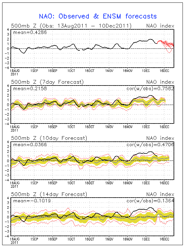
Thanks to the postive NAO this year every time a shortwave trough passes close to FL it moves away pretty fast and surface winds turn from NE& E off the milder Atlantic waters right away moderating our temps in the peninsula while areas to our north stay a little colder a little longer.
This year seems to be TX's turn.
Thanks to the postive NAO this year every time a shortwave trough passes close to FL it moves away pretty fast and surface winds turn from NE& E off the milder Atlantic waters right away moderating our temps in the peninsula while areas to our north stay a little colder a little longer.
0 likes
-
northjaxpro
- S2K Supporter
- Posts: 8900
- Joined: Mon Sep 27, 2010 11:21 am
- Location: Jacksonville, FL
Re:
NDG wrote:What a difference a year makes, one year ago much of central FL and even parts of south FL was under a freeze warning.
This year seems to be TX's turn.
Thanks to the postive NAO this year every time a shortwave trough passes close to FL it moves away pretty fast and surface winds turn from NE& E off the milder Atlantic waters right away moderating our temps in the peninsula while areas to our north stay a little colder a little longer.
Yeah, so far this has panned out. I have only recorded 2 mornings where the temperature dipped at or below freezing at my home in north Jacksonville. The mercury dipped to 30 degrees on November 12 and 32 degrees a couple of mornings ago on December 8.
It appears that the mild pattern will continue at least for now. The long range global model runs I have checked going out for the next 7-10 days does not indicate any signs of arctic air intrusions being drawn southward toward the Deep South and Florida. Compared to this time last year, this is definitely a major contrast as we are not in the icebox. We may get lucky this winter and escape the severe freezes here in JAX and the rest of North and Central FL if this current patttern can hold for another 4-6 weeks.
0 likes
NEVER, EVER SAY NEVER in the tropics and weather in general, and most importantly, with life itself!!
________________________________________________________________________________________
Fay 2008 Beryl 2012 Debby 2012 Colin 2016 Hermine 2016 Julia 2016 Matthew 2016 Irma 2017 Dorian 2019
________________________________________________________________________________________
Fay 2008 Beryl 2012 Debby 2012 Colin 2016 Hermine 2016 Julia 2016 Matthew 2016 Irma 2017 Dorian 2019
Re: Re:
northjaxpro wrote:NDG wrote:What a difference a year makes, one year ago much of central FL and even parts of south FL was under a freeze warning.
This year seems to be TX's turn.
Thanks to the postive NAO this year every time a shortwave trough passes close to FL it moves away pretty fast and surface winds turn from NE& E off the milder Atlantic waters right away moderating our temps in the peninsula while areas to our north stay a little colder a little longer.
Yeah, so far this has panned out. I have only recorded 2 mornings where the temperature dipped at or below freezing at my home in north Jacksonville. The mercury dipped to 30 degrees on November 12 and 32 degrees a couple of mornings ago on December 8.
It appears that the mild pattern will continue at least for now. The long range global model runs I have checked going out for the next 7-10 days does not indicate any signs of arctic air intrusions being drawn southward toward the Deep South and Florida. Compared to this time last year, this is definitely a major contrast as we are not in the icebox. We may get lucky this winter and escape the severe freezes here in JAX and the rest of North and Central FL if this current patttern can hold for another 4-6 weeks.
Heck if this pattern holds most of central FL may not even get a freeze this winter.
No end in sight of this current positive NAO phase, at least through the end of the month.
0 likes
Re: Florida Fall 2011 Winter 2011-2012
I've seen SFL winters start kinda like this, yet turn pretty cold for about 2 weeks at the beginning of January. Seems like this winter might be different, though - even when a front has managed to clear the peninsula, the temperature change has not been very drastic....and even the minor cooldowns have moderated quickly. This weather reminds me more of the middle of April than December.
Where was all this persistent ridging in the hurricane season?
Where was all this persistent ridging in the hurricane season?
0 likes
Who is online
Users browsing this forum: No registered users and 259 guests