Texas Winter 2011-2012...
Moderator: S2k Moderators
Forum rules
 The posts in this forum are NOT official forecast and should not be used as such. They are just the opinion of the poster and may or may not be backed by sound meteorological data. They are NOT endorsed by any professional institution or STORM2K.

The posts in this forum are NOT official forecast and should not be used as such. They are just the opinion of the poster and may or may not be backed by sound meteorological data. They are NOT endorsed by any professional institution or STORM2K.
-
TwisterFanatic

- Category 5

- Posts: 1041
- Joined: Mon Jun 28, 2010 12:43 pm
- Location: Sallisaw, Oklahoma
By 180 hours, the CMC has a big system coming out of the four corners region also.
0 likes
Personal Forecast Disclaimer:
The posts in this forum are NOT official forecast and should not be used as such. They are just the opinion of the poster and may or may not be backed by sound meteorological data. They are NOT endorsed by any professional institution or storm2k.org. For official information, please refer to the NHC and NWS products.
The posts in this forum are NOT official forecast and should not be used as such. They are just the opinion of the poster and may or may not be backed by sound meteorological data. They are NOT endorsed by any professional institution or storm2k.org. For official information, please refer to the NHC and NWS products.
-
Rgv20

- S2K Supporter

- Posts: 2466
- Age: 39
- Joined: Wed Jan 05, 2011 5:42 pm
- Location: Edinburg/McAllen Tx
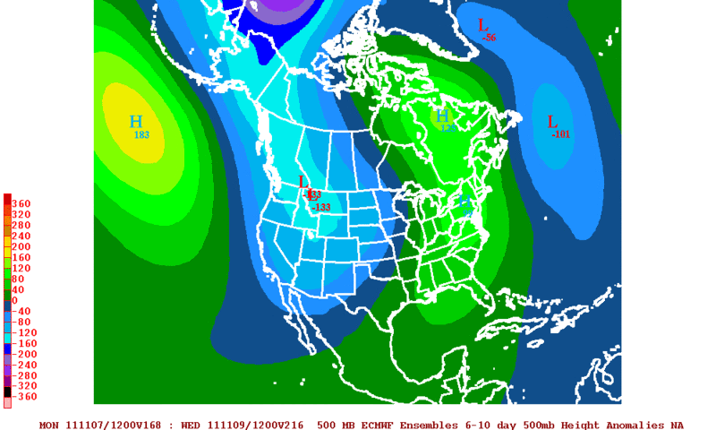
This is the forecast 500mb Anomalies from the 12zECMWF Ensembles for Nov6 to Nov10.
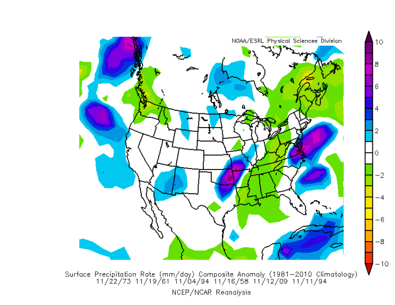
The following graphic are some analog dates of the 500mb Anomalies for Nov6 to Nov10.
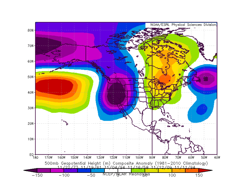
Taking a look at the precipitation anomalies for the same analog dates it looks like some rainy days is in store for North Texas, parts of Oklahoma and Eastern Arkansas. This coincides very well with the 12zECMWF&12zGFS forecast rainfall in the 6 to 10 day time frame.
The 0zECMWF Ensemble Control Run wants to paint a wet picture for most of Texas but I think most of the rain will stay north of Central,Eastern, and South Texas
The following graphic are some analog dates of the 500mb Anomalies for Nov6 to Nov10.
Taking a look at the precipitation anomalies for the same analog dates it looks like some rainy days is in store for North Texas, parts of Oklahoma and Eastern Arkansas. This coincides very well with the 12zECMWF&12zGFS forecast rainfall in the 6 to 10 day time frame.
The 0zECMWF Ensemble Control Run wants to paint a wet picture for most of Texas but I think most of the rain will stay north of Central,Eastern, and South Texas
0 likes
The following post is NOT an official forecast and should not be used as such. It is just the opinion of the poster and may or may not be backed by sound meteorological data. It is NOT endorsed by any professional institution including storm2k.org For Official Information please refer to the NHC and NWS products.

Re: Texas Winter 2011-2012...
Check out the forecast for the TX Pandhandle.
Wednesday: Rain and snow likely before 1pm, then a chance of snow. Mostly cloudy, with a high near 36. Wind chill values between 19 and 24. Very windy, with a north northwest wind between 30 and 35 mph, with gusts as high as 55 mph. Chance of precipitation is 60%. New snow accumulation of less than 1 inch possible.
It feels like the panhandle climate is completely different from the rest of Texas.
0 likes
-
TeamPlayersBlue

- Category 5
- Posts: 3533
- Joined: Tue Feb 02, 2010 1:44 am
- Location: Denver/Applewood, CO
looks like after our second panhandle hooker, the GFS is showing a very strong winter storm for the upper midwest.
0 likes
Personal Forecast Disclaimer:
The posts in this forum are NOT official forecast and should not be used as such. They are just the opinion of the poster and may or may not be backed by sound meteorological data. They are NOT endorsed by any professional institution or storm2k.org. For official information, please refer to the NHC and NWS products.
The posts in this forum are NOT official forecast and should not be used as such. They are just the opinion of the poster and may or may not be backed by sound meteorological data. They are NOT endorsed by any professional institution or storm2k.org. For official information, please refer to the NHC and NWS products.
-
cycloneye

- Admin

- Posts: 149725
- Age: 69
- Joined: Thu Oct 10, 2002 10:54 am
- Location: San Juan, Puerto Rico
Re: Texas Winter 2011-2012...

A bitter cold snap for the state with a 1033 mb high on top if this 12z GFS on the 15th pans out.But you know the drill about these long range forecasts.

Uploaded by imageshack.us
0 likes
Visit the Caribbean-Central America Weather Thread where you can find at first post web cams,radars
and observations from Caribbean basin members Click Here
and observations from Caribbean basin members Click Here
-
TeamPlayersBlue
- Category 5
- Posts: 3533
- Joined: Tue Feb 02, 2010 1:44 am
- Location: Denver/Applewood, CO
The GFS is trying to sniff something interesting for mid-late Nov. Look at the 500 MB chart..... Looks interesting as well but again, its very early.
0 likes
Personal Forecast Disclaimer:
The posts in this forum are NOT official forecast and should not be used as such. They are just the opinion of the poster and may or may not be backed by sound meteorological data. They are NOT endorsed by any professional institution or storm2k.org. For official information, please refer to the NHC and NWS products.
The posts in this forum are NOT official forecast and should not be used as such. They are just the opinion of the poster and may or may not be backed by sound meteorological data. They are NOT endorsed by any professional institution or storm2k.org. For official information, please refer to the NHC and NWS products.
-
cycloneye
- Admin
- Posts: 149725
- Age: 69
- Joined: Thu Oct 10, 2002 10:54 am
- Location: San Juan, Puerto Rico
Re: Texas Winter 2011-2012...
Looking very wet especially for the NorthCentral part of the state on the 8th if today's 12z Euro is right.

0 likes
Visit the Caribbean-Central America Weather Thread where you can find at first post web cams,radars
and observations from Caribbean basin members Click Here
and observations from Caribbean basin members Click Here
-
Rgv20
- S2K Supporter
- Posts: 2466
- Age: 39
- Joined: Wed Jan 05, 2011 5:42 pm
- Location: Edinburg/McAllen Tx
The NWS Brownsville had a very informative end of the year preview this afternoon. http://www.srh.noaa.gov/bro/?n=2011_autumnoutlook I thought the last part below was very very interesting...will just have to wait and see.
January and Beyond: Will the AO/NAO Play A Role?
In the winters of 2010 and 2011, the Arctic Oscillation (AO) and its related offspring, the North Atlantic Oscillation (NAO) fell sharply negative. When combined with 2010’s El Niño, the pattern helped develop several Texas Gulf lows which provided ample precipitation to the Valley in December (2009) and February, and brought periodic cooling to the area. Several of these developing cyclones would move through the northern Gulf and eventually turn into significant winter storms along the eastern U.S. seaboard. When combined with 2011’s La Niña, the pattern helped bring periodic arctic–sourced high pressure ridges into the eastern half of North America, particularly from mid January through mid February. This helped increase wintry precipitation totals in the east, and brought chilling fronts into Texas through mid February. One front drew very cold air into the Rio Grande Valley to start February, leading to a significant freeze and ice storm February 2nd through 5th. While no two seasons are exactly alike, the potential exists for some winter weather between mid December and mid February. Some studies shows a relationship between loss of arctic sea ice and an increased potential for a negative phase AO/NAO. Will this occur again later this autumn and winter? Stay tuned.
0 likes
The following post is NOT an official forecast and should not be used as such. It is just the opinion of the poster and may or may not be backed by sound meteorological data. It is NOT endorsed by any professional institution including storm2k.org For Official Information please refer to the NHC and NWS products.
-
somethingfunny

- ChatStaff

- Posts: 3926
- Age: 37
- Joined: Thu May 31, 2007 10:30 pm
- Location: McKinney, Texas
Interesting, the GFS hasn't dropped that 11/15 date for the first major freeze. Usually these cold snaps get pushed back and pushed back and always stay out there by 384 hours. I know, it's still 336 hours out, but it's progress. 
We'll see if the cold air in that forecast moderates as we get closer to mid November but I think the date of that cold snap might be a reliable bet.
We'll see if the cold air in that forecast moderates as we get closer to mid November but I think the date of that cold snap might be a reliable bet.
0 likes
I am not a meteorologist, and any posts made by me are not official forecasts or to be interpreted as being intelligent. These posts are just my opinions and are probably silly opinions.
-
TeamPlayersBlue
- Category 5
- Posts: 3533
- Joined: Tue Feb 02, 2010 1:44 am
- Location: Denver/Applewood, CO
http://www.examiner.com/weather-in-hous ... ber-3-2011
LC is still a believer in a cold second half of November. At least we have something exciting to watch for the month!
LC is still a believer in a cold second half of November. At least we have something exciting to watch for the month!
0 likes
Personal Forecast Disclaimer:
The posts in this forum are NOT official forecast and should not be used as such. They are just the opinion of the poster and may or may not be backed by sound meteorological data. They are NOT endorsed by any professional institution or storm2k.org. For official information, please refer to the NHC and NWS products.
The posts in this forum are NOT official forecast and should not be used as such. They are just the opinion of the poster and may or may not be backed by sound meteorological data. They are NOT endorsed by any professional institution or storm2k.org. For official information, please refer to the NHC and NWS products.

Re: Texas Winter 2011-2012...
Freeze warning for San Angelo area tonight. If it happens we'll beat our average first freeze by 10 days.
0 likes
-
cycloneye
- Admin
- Posts: 149725
- Age: 69
- Joined: Thu Oct 10, 2002 10:54 am
- Location: San Juan, Puerto Rico
Re: Texas Winter 2011-2012...
12z ECMWF at 120 hours has plenty of precipitation for most of the state.

0 likes
Visit the Caribbean-Central America Weather Thread where you can find at first post web cams,radars
and observations from Caribbean basin members Click Here
and observations from Caribbean basin members Click Here
Re: Texas Winter 2011-2012...
natlib wrote:Freeze warning for San Angelo area tonight. If it happens we'll beat our average first freeze by 10 days.
Awesome. My average first freeze is the same but we've yet to officially reach 32 (we dripped into the 30s about 5 days). Sadly it looks like no chance of a freeze here until late November.
0 likes
-
aggiecutter
- Category 5
- Posts: 1755
- Joined: Thu Oct 14, 2004 9:22 pm
- Location: Texarkana
Re: Texas Winter 2011-2012...
Winter forecast from Raleigh WX. I pretty much agree with what he says. According to his forecast, the southern plains and Texas should see periods of cold to very cold weather, with chances for snow an ice. The link below starts at the 1st slide of his slideshow presentation.
http://www.examiner.com/weather-in-rale ... st-picture
http://www.examiner.com/weather-in-rale ... st-picture
0 likes
-
Rgv20
- S2K Supporter
- Posts: 2466
- Age: 39
- Joined: Wed Jan 05, 2011 5:42 pm
- Location: Edinburg/McAllen Tx
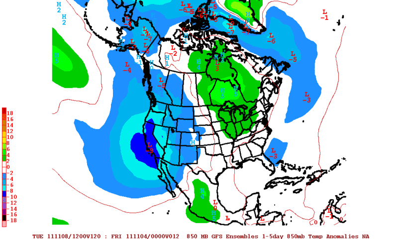
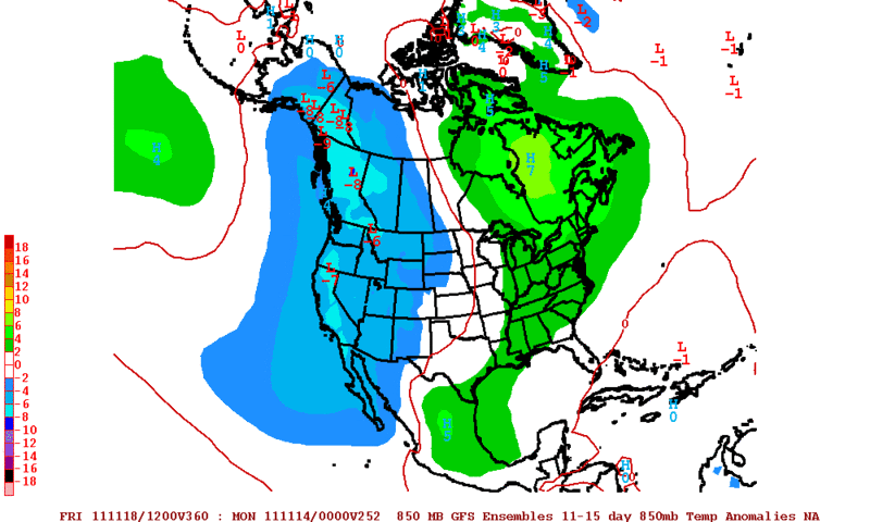
Overall it looks like the next 15 days is going to be above normal in the temperature department for the state of Texas. It looks like the cool weather is going to stick over the western part of the country for a while.
12zGFS Ensembles Forecast 850mb Anomalies for Nov 3 thru Nov 8.
12zGFS Ensembles Forecast 850mb Anomalies for Nov 9 thru Nov 13.
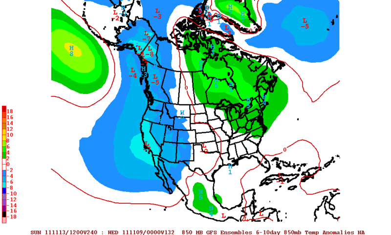
12zGFS Ensembles Forecast 850mb Anomalies for Nov 14 thru Nov 18.
12zGFS Ensembles Forecast 850mb Anomalies for Nov 3 thru Nov 8.
12zGFS Ensembles Forecast 850mb Anomalies for Nov 9 thru Nov 13.
12zGFS Ensembles Forecast 850mb Anomalies for Nov 14 thru Nov 18.
0 likes
The following post is NOT an official forecast and should not be used as such. It is just the opinion of the poster and may or may not be backed by sound meteorological data. It is NOT endorsed by any professional institution including storm2k.org For Official Information please refer to the NHC and NWS products.
-
HockeyTx82
- S2K Supporter
- Posts: 2814
- Joined: Tue Oct 27, 2009 11:17 am
- Location: Ponder, TX
Re: Texas Winter 2011-2012...
I took a peek and just before 8 this morning the temp on NOAA's website for Denton was 28!!!!! GOODBYE RAGWEED!!!!!!!!!!!! At least I hope it killed it all off. 
0 likes
Don't hold me accountable for anything I post on this forum. Leave the real forecasting up to the professionals.
Location: Ponder, TX (all observation posts are this location unless otherwise noted)
Location: Ponder, TX (all observation posts are this location unless otherwise noted)
-
CaptinCrunch

- S2K Supporter
- Posts: 8784
- Age: 58
- Joined: Mon Nov 03, 2003 4:33 pm
- Location: Kennedale, TX (Tarrant Co.)
-
vbhoutex

- Storm2k Executive
- Posts: 29150
- Age: 74
- Joined: Wed Oct 09, 2002 11:31 pm
- Location: Cypress, TX
- Contact:
Re: Texas Winter 2011-2012...
We only got to 38f here at the house in Houston, but outlying metro areas were at 30-32f. Quick warm up with 80f expected for Sunday.
0 likes
Skywarn, C.E.R.T.
Please click below to donate to STORM2K to help with the expenses of keeping the site going:

Please click below to donate to STORM2K to help with the expenses of keeping the site going:
-
Portastorm

- Storm2k Moderator

- Posts: 9955
- Age: 63
- Joined: Fri Jul 11, 2003 9:16 am
- Location: Round Rock, TX
- Contact:
Re: Texas Winter 2011-2012...
Dropped just below freezing (31 degrees) at the Portastorm Weather Center in scenic southwest Travis County. Area just outside the downtown/urban core were in the upper 20s/low 30s but the central/urban core areas stayed in the middle 30s. ABIA (airport) bottomed out at 26.
0 likes
Any forecasts under my name are to be taken with a grain of salt. Get your best forecasts from the National Weather Service and National Hurricane Center.
Who is online
Users browsing this forum: No registered users and 202 guests