Satellite indicated. Look at the convection. I guess this is the first time we have ever seen a center relocate???SFLcane wrote:ronjon wrote:SFLcane wrote:Most models shear this thing out or bury it in the yucatan as frontal boundary moves into the gulf next week.
Yeah, that's what they said about Wilma too, LOL. Now, I'm certainly not comparing future Rina to that intensity, but this system will be traveling in the direction of the shear (uni-directional). Shear will be strongest the further north it travels in the GOM. No doubt it'll be sheared if reaches 28N and beyond, but even sheared systems can maintain TS strength which can cause torrential rain, winds, and possible tornadoes.
Not sure most models had the center so far north off the NE tip of the Yucatan. This new low center may change the models.
TPC has the low still inland. The current thinking is not even remotely close to wilma. Both GFS/ECM entrain what ever is left of the low into the frontal boundary next week enhanceing rainfall over SFL.
ATL: INVEST 95L - Discussion
Moderator: S2k Moderators
-
Rainband
Re: ATL: INVEST 95L - Discussion

0 likes


-
caneman
Re: ATL: INVEST 95L - Discussion
SFLcane wrote:ronjon wrote:SFLcane wrote:Most models shear this thing out or bury it in the yucatan as frontal boundary moves into the gulf next week.
Yeah, that's what they said about Wilma too, LOL. Now, I'm certainly not comparing future Rina to that intensity, but this system will be traveling in the direction of the shear (uni-directional). Shear will be strongest the further north it travels in the GOM. No doubt it'll be sheared if reaches 28N and beyond, but even sheared systems can maintain TS strength which can cause torrential rain, winds, and possible tornadoes.
Not sure most models had the center so far north off the NE tip of the Yucatan. This new low center may change the models.
TPC has the low still inland. The current thinking is not even remotely close to wilma. Both GFS/ECM entrain what ever is left of the low into the frontal boundary next week enhanceing rainfall over SFL.
How can you site the models when those models have no clue as to what is taking place? Watch the Sat. not the clueless models and you'll be in far better shape
0 likes
-
caneman
Re: ATL: INVEST 95L - Discussion
And if you have to watch the models, look at the current ones just released.
0 likes
-
HurricaneBelle

- S2K Supporter

- Posts: 1209
- Joined: Sun Aug 27, 2006 6:12 pm
- Location: Clearwater, FL
Re: ATL: INVEST 95L - Discussion
This setup is reminding me quite a bit of 1988's Tropical Storm Keith, which made landfall just south of Tampa Bay near Sarasota as a 65MPH TS.
http://en.wikipedia.org/wiki/Tropical_Storm_Keith_(1988)
http://en.wikipedia.org/wiki/Tropical_Storm_Keith_(1988)
0 likes


Re: ATL: INVEST 95L - Discussion
Circulation is better defined today. Looking at the image below it appears that the low may be slightly offshore if not right on the coast.

0 likes
The following post is NOT an official forecast and should not be used as such. It is just the opinion of the poster and may or may not be backed by sound meteorological data. It is NOT endorsed by any professional institution including storm2k.org For Official Information please refer to the NHC and NWS products.
-
HurricaneBelle
- S2K Supporter
- Posts: 1209
- Joined: Sun Aug 27, 2006 6:12 pm
- Location: Clearwater, FL
Re: ATL: INVEST 95L - Discussion
Suddenly the NAM run from Thursday depicted in this post and valid for 8PM Eastern tonight doesn't look so absurd:
viewtopic.php?p=2200690#p2200690
viewtopic.php?p=2200690#p2200690
0 likes
-
Blown Away

- S2K Supporter
- Posts: 10253
- Joined: Wed May 26, 2004 6:17 am
Re: ATL: INVEST 95L - Discussion
 http://www.nhc.noaa.gov/tafb_latest/atl ... BW_sm3.gif
72 hour TAFB has 95L as a possible Tropical Cyclone moving towards the NE after making a turn over the Yucatan.
0 likes
Hurricane Eye Experience: David 79, Irene 99, Frances 04, Jeanne 04, Wilma 05… Hurricane Brush Experience: Andrew 92, Erin 95, Floyd 99, Matthew 16, Irma 17, Ian 22, Nicole 22…
-
maxx9512
- Tropical Storm

- Posts: 114
- Age: 66
- Joined: Thu May 31, 2007 7:55 pm
- Location: Cape Coral, Fl.
Re: ATL: INVEST 95L - Discussion
95L models using Google Earth
[img]
[/img]
[img]

[/img]
Last edited by maxx9512 on Sun Oct 16, 2011 8:56 am, edited 2 times in total.
0 likes

The following post is NOT an official forecast and should not be used as such. It is just the opinion of the poster and may or may not be backed by sound meteorological data. It is NOT endorsed by any professional institution including storm2k.org. For Official Information please refer to the NHC and NWS products.
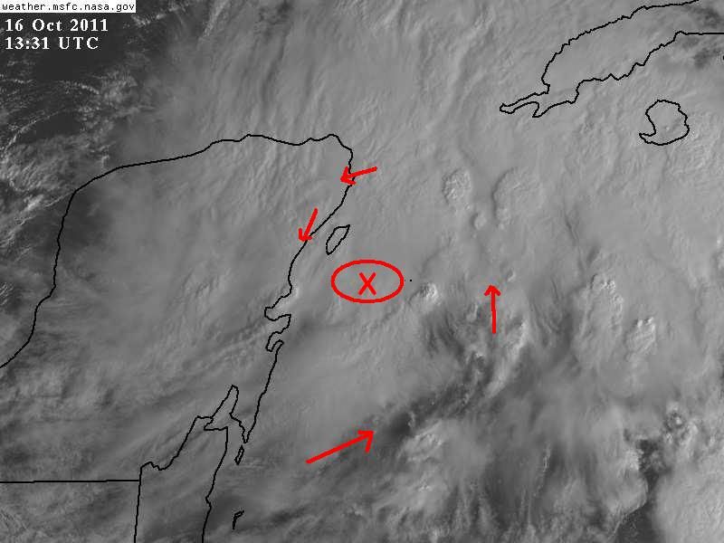
This is where I see a possible surface COC, just SE or SSE of Cozumel, a bit elongated SW to NE perhaps, centered near 20N & 86.5W
Arrows I placed are either reported by surface observations and seen in the vis sat loop, SW to westerly winds clearly seen on vis sat loop to the south of my estimated COC.
0 likes
-
cycloneye

- Admin

- Posts: 149425
- Age: 69
- Joined: Thu Oct 10, 2002 10:54 am
- Location: San Juan, Puerto Rico
Re: ATL: INVEST 95L - Discussion
blp wrote:Circulation is better defined today. Looking at the image below it appears that the low may be slightly offshore if not right on the coast.
http://img851.imageshack.us/img851/2944/wmbas76.png
Not to dampen what you said ,but to tell the real deal of the graphic,that pass was made last night at 10:34 PM EDT. But I agree about the low better defined.
0 likes
Visit the Caribbean-Central America Weather Thread where you can find at first post web cams,radars
and observations from Caribbean basin members Click Here
and observations from Caribbean basin members Click Here
-
Rainband
Re:
I agree but who knows. My eyes are playing tricks on me according to the NHC. Time for a breakNDG wrote:This is where I see a possible surface COC, just SE or SSE of Cozumel, a bit elongated SW to NE perhaps, centered near 20N & 86.5W
Arrows I placed are either reported by surface observations and seen in the vis sat loop, SW to westerly winds clearly seen on vis sat loop to the south of my estimated COC.
http://i20.photobucket.com/albums/b245/ ... QQLko1.jpg
0 likes
-
cycloneye
- Admin
- Posts: 149425
- Age: 69
- Joined: Thu Oct 10, 2002 10:54 am
- Location: San Juan, Puerto Rico
Re:
[quote="NDG"]
This is where I see a possible surface COC, just SE or SSE of Cozumel, a bit elongated SW to NE perhaps, centered near 20N & 86.5W
Arrows I placed are either reported by surface observations and seen in the vis sat loop, SW to westerly winds clearly seen on vis sat loop to the south of my estimated COC.
http://i20.photobucket.com/albums/b245/ ... QQLko1.jpg{/quote]
NDG,I put the S2K disclaimer to your post.
0 likes
Visit the Caribbean-Central America Weather Thread where you can find at first post web cams,radars
and observations from Caribbean basin members Click Here
and observations from Caribbean basin members Click Here
Re: Re:
cycloneye wrote:NDG wrote:This is where I see a possible surface COC, just SE or SSE of Cozumel, a bit elongated SW to NE perhaps, centered near 20N & 86.5W
Arrows I placed are either reported by surface observations and seen in the vis sat loop, SW to westerly winds clearly seen on vis sat loop to the south of my estimated COC.
http://i20.photobucket.com/albums/b245/ ... QQLko1.jpg{/quote]
NDG,I put the S2K disclaimer to your post.
OK thanks.
0 likes
-
cycloneye
- Admin
- Posts: 149425
- Age: 69
- Joined: Thu Oct 10, 2002 10:54 am
- Location: San Juan, Puerto Rico
Re: ATL: INVEST 95L - Discussion
Nothing new from ATCF about renumbering it at this time,but that could change later today so stay tuned. If they renumber 95L,it would be the 4th number 95 that is renumbered this season.
ftp://ftp.tpc.ncep.noaa.gov/atcf/tcweb/
ftp://ftp.tpc.ncep.noaa.gov/atcf/tcweb/
0 likes
Visit the Caribbean-Central America Weather Thread where you can find at first post web cams,radars
and observations from Caribbean basin members Click Here
and observations from Caribbean basin members Click Here
Re: ATL: INVEST 95L - Discussion
You can seem some fanning of the cirrus clouds on the edge of the system - you often see that with developing systems


0 likes
Re: ATL: INVEST 95L - Discussion
Definitely something down there this morning - we'll see what happens...
Frank
Frank
0 likes
Re: ATL: INVEST 95L - Discussion
I see the low level center over Yucatan with a sheared top bursting over the channel.
This was a no brainer, as someone said. Only it got choked by land interaction. Maybe it will get pulled north. Gradient gusts here.
This was a no brainer, as someone said. Only it got choked by land interaction. Maybe it will get pulled north. Gradient gusts here.
0 likes
-
wxman57

- Moderator-Pro Met

- Posts: 23174
- Age: 68
- Joined: Sat Jun 21, 2003 8:06 pm
- Location: Houston, TX (southwest)
Re: ATL: INVEST 95L - Discussion
Observations put the actual low center inland about 50 miles north of Belize. But if thunderstorms become more concentrated between the Yucatan & Cuba then a new center could form. The cold front should pick it up Tuesday and drive the precip toward south Florida. Could become a weak TS before then.
0 likes
Re: ATL: INVEST 95L - Discussion
It seemed an October Gulf storm was likely this year since the west basin wasn't active during the Cape Verde season. However the environment hasn't been favorable near CONUS so these sheared rainers are the result. Anything can happen though...
0 likes
Who is online
Users browsing this forum: No registered users and 8 guests