Back from the dead.
B. TROPICAL DISTURBANCE SUMMARY:
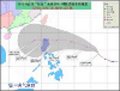
(1) AN AREA OF CONVECTION HAS PERSISTED NEAR 10.6N 133.3E,
APPROXIMATELY 200 NM NORTH-NORTHWEST OF PALAU. ANIMATED
MULTISPECTRAL SATELLITE IMAGERY SHOWS DISORGANZIED CONVECTION
AROUND A PERSISTENT LOW LEVEL CIRCULATION CENTER (LLCC). THE
040000Z PGTW STREAMLINE ANALYSIS REVEALS A SMALL ANTICYCLONE OVER
THE TOP OF THE SYSTEM AND WELL DEVELOPED SOUTHWESTERLIES FEEDING
INTO THE GRADIENT LEVEL. THE LLCC EXISTS WITHIN THE MONSOON TROUGH
IN A REGION OF WEAK VERTICAL WIND SHEAR AND 30 TO 31 DEGREE SEA
SURFACE TEMPERATURES. A 032347Z SSMIS IMAGE REVEALS LITTLE
CURVATURE OR ORGANZATION IN THE CONVECTIVE BANDING. MAXIMUM
SUSTAINED SURFACE WINDS ARE ESTIMATED AT 10 TO 15 KNOTS. MINIMUM
SEA LEVEL PRESSURE IS ESTIMATED TO BE NEAR 1008 MB. THE POTENTIAL
FOR THE DEVELOPMENT OF A SIGNIFICANT TROPICAL CYCLONE WITHIN THE
NEXT 24 HOURS IS LOW.
http://www.goes.noaa.gov/sohemi/sohemiloops/vsmtsatw.htmlVisible satellite loop shows quite good cyclonic spin near the area. I'm surprised that Euro was in fact showing a tropical system developing out of it but keeping it very weak in the previous runs, but the latest 00z run shows a more pronounced but still a weak system.