
LUBBOCK, Texas — Texas just finished the hottest June through August on record for any state in the U.S., weather officials said Thursday .National Weather Service meteorologist Victor Murphy told The Associated Press that Texas' 86.8 degree Fahrenheit average beat out Oklahoma's 85.2 degrees in 1934. That Dust Bowl year is now third on the list for the three-month span, behind No. 2 Oklahoma's heat wave this June through August at 86.5 degrees.
C/S TX Weather: Seasonal with some rains
Moderator: S2k Moderators
Forum rules

The posts in this forum are NOT official forecast and should not be used as such. They are just the opinion of the poster and may or may not be backed by sound meteorological data. They are NOT endorsed by any professional institution or STORM2K.
Re: C/S TX Weather: Extreme Fire Danger!
Here's an interesting fact from msnbc. Texas and Oklahoma both jumped Oklahoma's dust bowl summer of 1934 as the warmest average temp for any state any year.
0 likes
The above post and any post by Ntxw is NOT an official forecast and should not be used as such. It is just the opinion of the poster and may or may not be backed by sound meteorological data. It is NOT endorsed by any professional institution including Storm2k. For official information, please refer to NWS products.
Help support Storm2K!
From NOAA


NOAA’s Climate Prediction Center: La Niña is back
September 8, 2011
La Niña, which contributed to extreme weather around the globe during the first half of 2011, has re-emerged in the tropical Pacific Ocean and is forecast to gradually strengthen and continue into winter. Today, forecasters with NOAA’s Climate Prediction Center upgraded last month’s La Niña Watch to a La Niña Advisory.
NOAA will issue its official winter outlook in mid-October, but La Niña winters often see drier than normal conditions across the southern tier of the United States and wetter than normal conditions in the Pacific Northwest and Ohio Valley.
“This means drought is likely to continue in the drought-stricken states of Texas, Oklahoma and New Mexico,” said Mike Halpert, deputy director of the Climate Prediction Center. “La Niña also often brings colder winters to the Pacific Northwest and the northern Plains, and warmer temperatures to the southern states.”
0 likes
-
somethingfunny

- ChatStaff

- Posts: 3926
- Age: 37
- Joined: Thu May 31, 2007 10:30 pm
- Location: McKinney, Texas
Re: C/S TX Weather: Extreme Fire Danger!
Ntxw wrote:Here's an interesting fact from msnbc. Texas and Oklahoma both jumped Oklahoma's dust bowl summer of 1934 as the warmest average temp for any state any year.LUBBOCK, Texas — Texas just finished the hottest June through August on record for any state in the U.S., weather officials said Thursday .National Weather Service meteorologist Victor Murphy told The Associated Press that Texas' 86.8 degree Fahrenheit average beat out Oklahoma's 85.2 degrees in 1934. That Dust Bowl year is now third on the list for the three-month span, behind No. 2 Oklahoma's heat wave this June through August at 86.5 degrees.
As long as we beat Oklahoma, everything we've endured this summer will have been worth it.
0 likes
I am not a meteorologist, and any posts made by me are not official forecasts or to be interpreted as being intelligent. These posts are just my opinions and are probably silly opinions.
-
cctxhurricanewatcher

- Category 5

- Posts: 1206
- Joined: Sun Sep 12, 2004 8:53 pm
- Location: Corpus Christi, Texas
Re:
Shoshana wrote:From NOAANOAA’s Climate Prediction Center: La Niña is back
September 8, 2011
La Niña, which contributed to extreme weather around the globe during the first half of 2011, has re-emerged in the tropical Pacific Ocean and is forecast to gradually strengthen and continue into winter. Today, forecasters with NOAA’s Climate Prediction Center upgraded last month’s La Niña Watch to a La Niña Advisory.
NOAA will issue its official winter outlook in mid-October, but La Niña winters often see drier than normal conditions across the southern tier of the United States and wetter than normal conditions in the Pacific Northwest and Ohio Valley.
“This means drought is likely to continue in the drought-stricken states of Texas, Oklahoma and New Mexico,” said Mike Halpert, deputy director of the Climate Prediction Center. “La Niña also often brings colder winters to the Pacific Northwest and the northern Plains, and warmer temperatures to the southern states.”
We need a throw up Smiley. Because that's what I want to do after reading this. Hopefully it will be one of those times the Einsteins at NOAA declare one thing and the opposite happends. Sort of like the twenty percent chance of rain ends up being twenty inches of rain.
0 likes
-
Portastorm

- Storm2k Moderator

- Posts: 9955
- Age: 63
- Joined: Fri Jul 11, 2003 9:16 am
- Location: Round Rock, TX
- Contact:
Re: C/S TX Weather: Extreme Fire Danger!
Before everyone here rushes for a sharp object ... there have been La Nina winters which had average or even above average precipitation. I'll have to go back and to the research, but I'm pretty sure last fall I saw/read something that indicated that 3 out of 10 La Nina winters in the Southern Plains/Texas exhibited those figures.
Other "signals" can overwhelm the Nina signal to create our weather. Remember how chilly last winter started, thanks to an overwhelming Arctic Oscillation?
Other "signals" can overwhelm the Nina signal to create our weather. Remember how chilly last winter started, thanks to an overwhelming Arctic Oscillation?
0 likes
Any forecasts under my name are to be taken with a grain of salt. Get your best forecasts from the National Weather Service and National Hurricane Center.
-
somethingfunny
- ChatStaff
- Posts: 3926
- Age: 37
- Joined: Thu May 31, 2007 10:30 pm
- Location: McKinney, Texas
Re: Re:
cctxhurricanewatcher wrote:
We need a throw up Smiley. Because that's what I want to do after reading this. Hopefully it will be one of those times the Einsteins at NOAA declare one thing and the opposite happends. Sort of like the twenty percent chance of rain ends up being twenty inches of rain.
Like this?

Maybe some of us are closer to this:

Honorable mentions:


All "borrowed" from SomethingAwful.com's forums but then rehosted to TinyPic.
0 likes
I am not a meteorologist, and any posts made by me are not official forecasts or to be interpreted as being intelligent. These posts are just my opinions and are probably silly opinions.
Re: C/S TX Weather: Extreme Fire Danger!
Portastorm wrote:Before everyone here rushes for a sharp object ... there have been La Nina winters which had average or even above average precipitation. I'll have to go back and to the research, but I'm pretty sure last fall I saw/read something that indicated that 3 out of 10 La Nina winters in the Southern Plains/Texas exhibited those figures.
Other "signals" can overwhelm the Nina signal to create our weather. Remember how chilly last winter started, thanks to an overwhelming Arctic Oscillation?
Very good points. There is more to weather patterns than La Nina. La Ninas provide plenty of cold air source, but the question is how much precip can overcome it. Texas will get rain in winter it's natural since the jet stream travels further south during this period, but can we get enough rain to face what will likely come next summer. My faith in that is dwindling at this time with the official announcement of La Nina by NOAA.
ECMWF is showing a socal low long range. Not that I believe it, it's just something I haven't seen in awhile and to wishcast for lol. Desperate times...
0 likes
The above post and any post by Ntxw is NOT an official forecast and should not be used as such. It is just the opinion of the poster and may or may not be backed by sound meteorological data. It is NOT endorsed by any professional institution including Storm2k. For official information, please refer to NWS products.
Help support Storm2K!
Help support Storm2K!
-
horselattitudesfarm

- Category 1

- Posts: 315
- Joined: Thu Jul 16, 2009 5:55 pm
- Location: Asheville, NC (formerly from Dallas, TX)
Re: C/S TX Weather: Extreme Fire Danger!
I guesss what I am really worried about is running out of water by next summer if we have a dry winter and spring. I know there really is no point in worrying about something that hasn't happened yet, but it is human nature to want to prepare for what could be an impending disaster for almost every city and town in Texas. Oh, by the way, I found this today in the NOAA drought thread:
•"An analysis of Texas statewide tree-ring records dating back to 1550 indicates that the summer 2011 drought in Texas is matched by only one summer (1789), indicating that the summer 2011 drought appears to be unusual even in the context of the multi-century tree-ring record. "
•"An analysis of Texas statewide tree-ring records dating back to 1550 indicates that the summer 2011 drought in Texas is matched by only one summer (1789), indicating that the summer 2011 drought appears to be unusual even in the context of the multi-century tree-ring record. "
0 likes
-
Rgv20

- S2K Supporter

- Posts: 2466
- Age: 39
- Joined: Wed Jan 05, 2011 5:42 pm
- Location: Edinburg/McAllen Tx
Well September is letting me down big time as far as Rainfall goes, It is our rainiest month here in the Rio Grande Valley and so far nothing..
Looking at the GFS and ECMWF it shows Central and South Texas remaining dry thru the next 7 days, hopefully the second half of September and October brings us some relief in the form of some much needed rainfall.
Looking at the GFS and ECMWF it shows Central and South Texas remaining dry thru the next 7 days, hopefully the second half of September and October brings us some relief in the form of some much needed rainfall.
0 likes
The following post is NOT an official forecast and should not be used as such. It is just the opinion of the poster and may or may not be backed by sound meteorological data. It is NOT endorsed by any professional institution including storm2k.org For Official Information please refer to the NHC and NWS products.
-
vbhoutex

- Storm2k Executive

- Posts: 29149
- Age: 74
- Joined: Wed Oct 09, 2002 11:31 pm
- Location: Cypress, TX
- Contact:
Re: C/S TX Weather: Extreme Fire Danger!
horselattitudesfarm wrote:I guesss what I am really worried about is running out of water by next summer if we have a dry winter and spring. I know there really is no point in worrying about something that hasn't happened yet, but it is human nature to want to prepare for what could be an impending disaster for almost every city and town in Texas. Oh, by the way, I found this today in the NOAA drought thread:
•"An analysis of Texas statewide tree-ring records dating back to 1550 indicates that the summer 2011 drought in Texas is matched by only one summer (1789), indicating that the summer 2011 drought appears to be unusual even in the context of the multi-century tree-ring record. "
Did you really have to tell us that good news??

I'm not sure I care to even think about it anymore after that!! Makes one wonder if the Southern plains are heading into a dust bowl type of period.
0 likes
Skywarn, C.E.R.T.
Please click below to donate to STORM2K to help with the expenses of keeping the site going:

Please click below to donate to STORM2K to help with the expenses of keeping the site going:

Re: C/S TX Weather: Extreme Fire Danger!
Portastorm wrote:Before everyone here rushes for a sharp object ... there have been La Nina winters which had average or even above average precipitation. I'll have to go back and to the research, but I'm pretty sure last fall I saw/read something that indicated that 3 out of 10 La Nina winters in the Southern Plains/Texas exhibited those figures.
Other "signals" can overwhelm the Nina signal to create our weather. Remember how chilly last winter started, thanks to an overwhelming Arctic Oscillation?
I have noticed that some La Ninas are wetter and cooler than other. 2000-2001 was a La Nina and it was cooler and wetter. So, hope is not all lost.
0 likes
Re: C/S TX Weather: Extreme Fire Danger!
horselattitudesfarm wrote:I guesss what I am really worried about is running out of water by next summer if we have a dry winter and spring. I know there really is no point in worrying about something that hasn't happened yet, but it is human nature to want to prepare for what could be an impending disaster for almost every city and town in Texas. Oh, by the way, I found this today in the NOAA drought thread:
•"An analysis of Texas statewide tree-ring records dating back to 1550 indicates that the summer 2011 drought in Texas is matched by only one summer (1789), indicating that the summer 2011 drought appears to be unusual even in the context of the multi-century tree-ring record. "
U.S. experiences second warmest summer on record
http://www.noaanews.noaa.gov/stories201 ... stats.html
0 likes
-
Rgv20
- S2K Supporter
- Posts: 2466
- Age: 39
- Joined: Wed Jan 05, 2011 5:42 pm
- Location: Edinburg/McAllen Tx
I know Portastorm is going to hate my post but I just do not see no Rainfall for most of Texas thru at least the next 7 days and possibly beyond. Maybe West Texas and the Panhandle my get a few showers Friday until the weekend but right now chances looks slim.
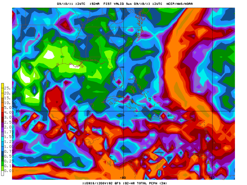
This is the 12zGFS total Rainfall thru 8 days and you can see it wants to hint at some rain in West Texas and South Texas. I'm not buying this solution yet as the ECMWF has been consistently showing a dry forecast for this same areas and the GFS has been trending toward a dryer forecast especially for North Texas.
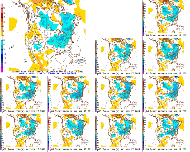
Now as far as temperatures thru the next 7 days there could be a couple of 100+ plus days for Dallas, Houston, and Austin area but not those extreme temperatures we saw last month. The graphic above is the 12zGFS Ensembles Temperature anomaly thru the next 7 days and it shows mostly normal Temperatures for the whole state except North Texas.
It looks like the Texas drought is only going to get worse (especially for Deep South Texas) as the September Rains have fail to come and with no signs of widespread rains in the next 7 to 10 days
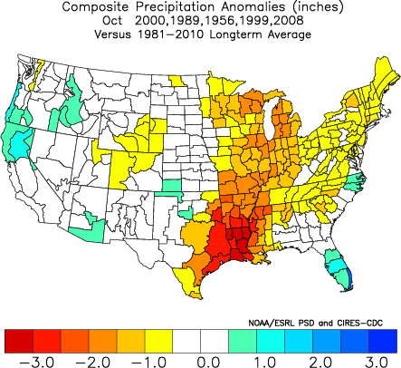
Looking beyond to October, the CFS forecasts below normal rainfall for all of Texas. IMO below are the analogs for October and it shows East Texas having way below normal rainfall.
This is the 12zGFS total Rainfall thru 8 days and you can see it wants to hint at some rain in West Texas and South Texas. I'm not buying this solution yet as the ECMWF has been consistently showing a dry forecast for this same areas and the GFS has been trending toward a dryer forecast especially for North Texas.
Now as far as temperatures thru the next 7 days there could be a couple of 100+ plus days for Dallas, Houston, and Austin area but not those extreme temperatures we saw last month. The graphic above is the 12zGFS Ensembles Temperature anomaly thru the next 7 days and it shows mostly normal Temperatures for the whole state except North Texas.
It looks like the Texas drought is only going to get worse (especially for Deep South Texas) as the September Rains have fail to come and with no signs of widespread rains in the next 7 to 10 days
Looking beyond to October, the CFS forecasts below normal rainfall for all of Texas. IMO below are the analogs for October and it shows East Texas having way below normal rainfall.
0 likes
The following post is NOT an official forecast and should not be used as such. It is just the opinion of the poster and may or may not be backed by sound meteorological data. It is NOT endorsed by any professional institution including storm2k.org For Official Information please refer to the NHC and NWS products.
-
Portastorm
- Storm2k Moderator
- Posts: 9955
- Age: 63
- Joined: Fri Jul 11, 2003 9:16 am
- Location: Round Rock, TX
- Contact:
Re: C/S TX Weather: Extreme Fire Danger!
No Rgv20, I don't hate your post. No need to shoot the messenger.
I think we all appreciate the information even if we don't like what it is telling us. We are essentially repeating a multiyear cycle which we had in the 1950s. "Funny" how history repeats itself.
0 likes
Any forecasts under my name are to be taken with a grain of salt. Get your best forecasts from the National Weather Service and National Hurricane Center.
(Mabry) Sun Day 82 100+ (New All Time Record)
Day 23 105+
27 in a row 100+ current record 2011!
(Bergstrom) Sun Day 68 100+ (New All Time Record)
104 at Mabry, new record high
Day 23 105+
27 in a row 100+ current record 2011!
(Bergstrom) Sun Day 68 100+ (New All Time Record)
104 at Mabry, new record high
Last edited by Shoshana on Sun Sep 11, 2011 7:07 pm, edited 1 time in total.
0 likes
Re: C/S TX Weather: Extreme Fire Danger!
Portastorm wrote::uarrow:
No Rgv20, I don't hate your post. No need to shoot the messenger.
I think we all appreciate the information even if we don't like what it is telling us. We are essentially repeating a multiyear cycle which we had in the 1950s. "Funny" how history repeats itself.
This drought thus far is shorter than the 50s. Are the effects of this one already as bad as the 50s or is it just my imagination, I was a young kid then, so could be remembering incorrectly.
0 likes
Any opinions stated are those of an amateur, please take with several grains of salt and for official forecast refer to the National Weather Service.
-
SaskatchewanScreamer
Re: C/S TX Weather: Extreme Fire Danger!
ndale wrote:Portastorm wrote::uarrow:
No Rgv20, I don't hate your post. No need to shoot the messenger.
I think we all appreciate the information even if we don't like what it is telling us. We are essentially repeating a multiyear cycle which we had in the 1950s. "Funny" how history repeats itself.
This drought thus far is shorter than the 50s. Are the effects of this one already as bad as the 50s or is it just my imagination, I was a young kid then, so could be remembering incorrectly.
I've been wondering that too since I also live in an area that was a dust bowl during the thirties (and like now Texas shared the heat overly generously) so I went looking:
http://earlywarn.blogspot.com/2011/04/texasoklahoma-drought-in-context.html
http://wattsupwiththat.com/2011/07/23/the-texas-centered-drought-versus-1918-1956-and-1934/
This fellow thinks its worse now (for the Southern affected States) http://thinkprogress.org/romm/2011/06/29/257741/texas-drought/
Tireman is the expert on this subject though RGv20 so hopefully he'll be by with your answer soon.
I know in the 1980's we went through a drought that they thought was much worse than the thirties (here in Saskatchewan) but with improved farming practices it didn't seem as bad (ie our topsoil didn't end up on Prince Edward Island). Up here we have had a number of bad droughts and some not so bad ones over the past 30 years when El Nino reigned (rain the past two years here is unbelieveable). Hope for both our locations normal weather patterns come back (oh what a dreamer am I).
The Dust Bowl however covered all of the Great Plains from Texas well up into the prairie provinces of Canada ie Alberta, Saskatchewan and Manitoba.
Last edited by SaskatchewanScreamer on Sun Sep 11, 2011 3:37 pm, edited 2 times in total.
0 likes
My concern is with water levels this low and vegatation already burned to a crisp, what would happen if this continued for an extended period of time.
0 likes
Any opinions stated are those of an amateur, please take with several grains of salt and for official forecast refer to the National Weather Service.


Humpf! For anything "wet" falling from the sky!
Hello,
I am a very long time lurker and joined a little while back. I am in central Texas in a VERY rural area. I have been trying to learn from the "elders" here and I have to say, I ain't easy! I have been watching the water Vapor map like some stalker following a pretty girl and I have to wonder exactly what is going on today... It looks to me like the "thing" (that's what I have come to call it) digging south is a little more eastward than anticipated....correction, what "I" anticipated. Completely amateurish, I know. But I have a great deal of WNW dark cloud cover coming in here where I am northwest of Austin.
I have to admit, I still have trouble understanding exactly what I am looking at as far as "weather" maps are concerned. But I am trying. Give me a legal treatise, and you've got a deal. Give me a conglomeration of weather models and I need some time.
Any who, grew up on the Gulf Coast near Pt. Arthur and remember evac-ing for Carla. I get that. This drought thing, not so much.
Nonetheless, hello!!
T2
0 likes
Return to “USA & Caribbean Weather”
Who is online
Users browsing this forum: No registered users and 121 guests