What is going on with this storm.
It wrapped around itself and slung a huge piece of moisture down into the southern gulf of mexico and now it seems detached..
It also threw a huge piece off towards the east and detached from that..
I've been watching the storms for 30 years and have never seen one like this one..
I wonder if something will develope down south now once the front stalls to it's north.... I'm perplexed..
Most complex tropical system I've ever seen..
Oh, And it swallowed a upper low and a piece of dry air that is still near the center..
ATL: LEE - Remnants - Discussion
Moderator: S2k Moderators
Re: ATL: LEE - Tropical Storm - Discussion
pwrdog wrote:What is going on with this storm.
It wrapped around itself and slung a huge piece of moisture down into the southern gulf of mexico and now it seems detached..
It also threw a huge piece off towards the east and detached from that..
I've been watching the storms for 30 years and have never seen one like this one..
I wonder if something will develope down south now once the front stalls to it's north.... I'm perplexed..
Most complex tropical system I've ever seen..
Oh, And it swallowed a upper low and a piece of dry air that is still near the center..
The GFS has developed something in the BoC in 4-5 days in the last couple of runs. I don't know if it's related to Lee but it could be something to watch next week.
0 likes
The following post is NOT an official forecast and should not be used as such. It is just the opinion of the poster and may or may not be backed by sound meteorological data. It is NOT endorsed by any professional institution including storm2k.org For Official Information please refer to the NHC and NWS products.
-
Houstonia

- S2K Supporter

- Posts: 829
- Age: 61
- Joined: Fri Oct 11, 2002 9:45 am
- Location: Sharpstown, Houston, Harris County, Southeast Texas.
Re: Re:
wxman57 wrote:southerngale wrote:I ended up with a couple of inches of rain from Lee yesterday. While more would have been nice, I was very grateful for what I got! It's been raining off and on today, but nothing like yesterday.
Had a good 4 inches at my house in southwest Houston. That's 4 inches between raindrops.
You must be in a different part of southwest Houston. Here in Sharpstown, there's been lots of wind (enough to worry me about all the dry branches), but very little rain since last night.
0 likes

Re: Re:
Houstonia wrote:wxman57 wrote:southerngale wrote:I ended up with a couple of inches of rain from Lee yesterday. While more would have been nice, I was very grateful for what I got! It's been raining off and on today, but nothing like yesterday.
Had a good 4 inches at my house in southwest Houston. That's 4 inches between raindrops.
You must be in a different part of southwest Houston. Here in Sharpstown, there's been lots of wind (enough to worry me about all the dry branches), but very little rain since last night.
re-read his post...
0 likes
Just like Jon Snow..."I know nothing" except what I know, and most of what I know is gathered by the fine people of the NHC
-
wxman57

- Moderator-Pro Met

- Posts: 23174
- Age: 68
- Joined: Sat Jun 21, 2003 8:06 pm
- Location: Houston, TX (southwest)
Re: ATL: LEE - Tropical Storm - Discussion
pwrdog wrote:What is going on with this storm.
It wrapped around itself and slung a huge piece of moisture down into the southern gulf of mexico and now it seems detached..
It also threw a huge piece off towards the east and detached from that..
I've been watching the storms for 30 years and have never seen one like this one..
I wonder if something will develope down south now once the front stalls to it's north.... I'm perplexed..
Most complex tropical system I've ever seen..
Oh, And it swallowed a upper low and a piece of dry air that is still near the center..
Lee is more of a subtropical cyclone than a tropical storm. Very common appearance. Large wind field but no intense winds, few squalls near the center. Dry air influx from the west isn't helping.
0 likes
-
cycloneye

- Admin

- Posts: 149425
- Age: 69
- Joined: Thu Oct 10, 2002 10:54 am
- Location: San Juan, Puerto Rico
Re: ATL: LEE - Advisories
BULLETIN
TROPICAL STORM LEE ADVISORY NUMBER 13
NWS NATIONAL HURRICANE CENTER MIAMI FL AL132011
400 PM CDT SUN SEP 04 2011
...LEE MOVING SLOWLY NORTHWARD OVER SOUTH-CENTRAL LOUISIANA...
EXPECTED TO TURN TOWARD THE EAST-NORTHEAST LATER TONIGHT...
SUMMARY OF 400 PM CDT...2100 UTC...INFORMATION
----------------------------------------------
LOCATION...30.6N 91.8W
ABOUT 30 MI...50 KM NNE OF LAFAYETTE LOUISIANA
ABOUT 110 MI...175 KM WNW OF NEW ORLEANS LOUISIANA
MAXIMUM SUSTAINED WINDS...45 MPH...75 KM/H
PRESENT MOVEMENT...N OR 5 DEGREES AT 5 MPH...7 KM/H
MINIMUM CENTRAL PRESSURE...987 MB...29.15 INCHES
WATCHES AND WARNINGS
--------------------
CHANGES WITH THIS ADVISORY...
THE TROPICAL STORM WARNING HAS BEEN DISCONTINUED FROM WEST OF MORGAN
CITY LOUISIANA WESTWARD TO INTRACOASTAL CITY LOUISIANA.
SUMMARY OF WATCHES AND WARNINGS IN EFFECT...
A TROPICAL STORM WARNING IS IN EFFECT FOR...
* DESTIN FLORIDA WESTWARD TO MORGAN CITY LOUISIANA...INCLUDING THE
CITY OF NEW ORLEANS...LAKE PONTCHARTRAIN...AND LAKE MAUREPAS
FOR STORM INFORMATION SPECIFIC TO YOUR AREA IN THE UNITED
STATES...INCLUDING POSSIBLE INLAND WATCHES AND WARNINGS...PLEASE
MONITOR PRODUCTS ISSUED BY YOUR LOCAL NATIONAL WEATHER SERVICE
FORECAST OFFICE.
DISCUSSION AND 48-HOUR OUTLOOK
------------------------------
AT 400 PM CDT...2100 UTC...THE CENTER OF TROPICAL STORM LEE WAS
LOCATED NEAR LATITUDE 30.6 NORTH...LONGITUDE 91.8 WEST. LEE IS
MOVING TOWARD THE NORTH NEAR 5 MPH...7 KM/H. SOME ERRATIC MOTION IS
POSSIBLE THIS AFTERNOON AND EVENING...AND LEE MAY BECOME STATIONARY
BEFORE TURNING TOWARD THE NORTHEAST OR EAST-NORTHEAST BY LATE
TONIGHT. ON THE FORECAST TRACK...THE CENTER WILL MOVE SLOWLY OVER
SOUTHERN AND SOUTHEASTERN LOUISIANA TONIGHT...AND ACROSS SOUTHERN
MISSISSIPPI BY LATE MONDAY.
MAXIMUM SUSTAINED WINDS REMAIN NEAR 45 MPH...75 KM/H...WITH HIGHER
GUSTS. GRADUAL WEAKENING IS FORECAST DURING THE NEXT COUPLE OF
DAYS.
TROPICAL-STORM-FORCE WINDS EXTEND OUTWARD UP TO 275 MILES...
445 KM...MAINLY EAST AND SOUTHEAST OF THE CENTER OVER WATER.
A NOAA BUOY JUST EAST OF THE MOUTH OF THE MISSISSIPPI RIVER
RECENTLY REPORTED A SUSTAINED WIND OF 36 MPH...57 KM/H AND A
GUST TO 43 MPH...69 KM/H. SEVERAL OFFSHORE OIL RIGS ALSO CONTINUE
TO REPORT SUSTAINED TROPICAL-STORM-FORCE WINDS A FEW HUNDRED FEET
ABOVE THE SURFACE WELL TO THE SOUTHEAST OF THE CENTER OF LEE.
A STORM SURGE VALUE OF MORE THAN 2 FEET RECENTLY OCCURRED JUST SOUTH
OF MORGAN CITY LOUISIANA AT AMERADA PASS.
REPORTS FROM SURFACE OBSERVATIONS INDICATE THE MINIMUM CENTRAL
PRESSURE IS 987 MB...29.15 INCHES.
HAZARDS AFFECTING LAND
----------------------
RAINFALL...TROPICAL STORM LEE IS EXPECTED TO PRODUCE TOTAL RAIN
ACCUMULATIONS OF 10 TO 15 INCHES ACROSS THE CENTRAL GULF COAST
REGION...WITH POSSIBLE ISOLATED MAXIMUM AMOUNTS OF 20 INCHES
THROUGH TUESDAY. HEAVY RAINS WILL CONTINUE TO EXPAND NORTHEASTWARD
INTO THE TENNESSEE VALLEY AND SOUTHERN APPALACHIAN MOUNTAINS
THROUGH TUESDAY WITH RAINFALL AMOUNTS OF 4 TO 8 INCHES EXPECTED...
WITH ISOLATED AMOUNTS OF 10 INCHES POSSIBLE. THESE RAINS ARE
EXPECTED TO CAUSE EXTENSIVE FLOODING AND FLASH FLOODING.
STORM SURGE...ELEVATED WATER LEVELS OF AS MUCH AS 3 TO 5 FEET ABOVE
GROUND LEVEL WILL CONTINUE TO OCCUR OVER PORTIONS OF SOUTHEASTERN
LOUISIANA AND COASTAL PORTIONS OF WESTERN MISSISSIPPI...AND BY AS
MUCH AS 1 TO 3 FEET ABOVE GROUND LEVEL ELSEWHERE WITHIN THE
TROPICAL STORM WARNING AREA. ELEVATED WATER LEVELS WILL BE SLOW TO
RECEDE DUE TO PERSISTENT ONSHORE WINDS.
WIND...TROPICAL STORM CONDITIONS ARE EXPECTED TO CONTINUE OVER
PORTIONS OF THE WARNING AREA TONIGHT AND MONDAY.
TORNADOES...A FEW TORNADOES WILL BE POSSIBLE TONIGHT AND MONDAY OVER
PORTIONS OF SOUTHERN LOUISIANA...SOUTHERN MISSISSIPPI...SOUTHERN
ALABAMA...THE FLORIDA PANHANDLE...AND EXTREME SOUTHWESTERN GEORGIA.
NEXT ADVISORY
-------------
NEXT INTERMEDIATE ADVISORY...700 PM CDT.
NEXT COMPLETE ADVISORY...1000 PM CDT.
$$
FORECASTER STEWART
0 likes
Visit the Caribbean-Central America Weather Thread where you can find at first post web cams,radars
and observations from Caribbean basin members Click Here
and observations from Caribbean basin members Click Here
-
cycloneye
- Admin
- Posts: 149425
- Age: 69
- Joined: Thu Oct 10, 2002 10:54 am
- Location: San Juan, Puerto Rico
Re: ATL: LEE - Tropical Storm - Discussion
...LEE MOVING SLOWLY NORTHWARD OVER SOUTH-CENTRAL LOUISIANA...
EXPECTED TO TURN TOWARD THE EAST-NORTHEAST LATER TONIGHT...
SUMMARY OF 400 PM CDT...2100 UTC...INFORMATION
----------------------------------------------
LOCATION...30.6N 91.8W
ABOUT 30 MI...50 KM NNE OF LAFAYETTE LOUISIANA
ABOUT 110 MI...175 KM WNW OF NEW ORLEANS LOUISIANA
MAXIMUM SUSTAINED WINDS...45 MPH...75 KM/H
PRESENT MOVEMENT...N OR 5 DEGREES AT 5 MPH...7 KM/H
MINIMUM CENTRAL PRESSURE...987 MB...29.15 INCHES
0 likes
Visit the Caribbean-Central America Weather Thread where you can find at first post web cams,radars
and observations from Caribbean basin members Click Here
and observations from Caribbean basin members Click Here
-
Countrygirl911
- Tropical Depression

- Posts: 93
- Joined: Fri Jun 25, 2010 5:28 pm
- Location: Meadville, Mississippi
Re: ATL: LEE - Tropical Storm - Discussion
well finally got lights back on been in the dark with the wind and rain howling apparently a transformer down the road was on fire. now how long they stay on who knows we are expected to get up to 45 mph gusts tonight and tomorrow. and we have tornado watch and wind advisery till tomorrow night and tornado warnings popping up around us
0 likes
-
Kory
- Tropical Storm

- Posts: 200
- Age: 30
- Joined: Tue Aug 02, 2011 11:32 am
- Location: New Orleans, Louisiana
Re:
BigB0882 wrote:We were told to watch out for gusts possibly up to 65 mph today and tonight. I would like to know the highest gust reported in Baton Rouge. Probably 40 if we are lucky, lol
That was because the center was forecasted to move over Baton Rouge...now its to the NW of Baton Rouge. Expect wind gusts just over tropical storm force.
The posts in this forum are NOT official forecast and should not be used as such. They are just the opinion of the poster and may or may not be backed by sound meteorological data. They are NOT endorsed by any professional institution or storm2k.org. For official information, please refer to the NHC and NWS products.
0 likes
-
PTrackerLA

- Category 5

- Posts: 5281
- Age: 42
- Joined: Thu Oct 10, 2002 8:40 pm
- Location: Lafayette, LA
Re: ATL: LEE - Tropical Storm - Discussion
I don't think we even had a gust to 40mph but Lee brought us 5.40" of much needed rain so I'll take that! Starting to get cabin fever today though and there's a heavy mist falling with more rain possibly moving in from Lee's circulation to my north. Looking forward to a few nights in the upper 50's starting tomorrow night! What an unexpected change from the continuous heat this summer.
0 likes


Coming from South of Fairhope. Rain has started back up and thunder is echoing through the background of my t.v. There is a tornado near my house but the south east of me. There is a warning if you near Magnolia Springs, Foley, Robertsdale, Summerdale. Too close for comfort. And tornado warning that was for Mobile and Baldwin earlier was a real tornado over the bay. I have friend who was on the causeway and got a picture of the funnel cloud. The other
0 likes
-
Janie2006

- Category 5
- Posts: 1329
- Joined: Mon Sep 18, 2006 3:28 pm
- Location: coastal Ms aka home of the hurricanes
Re: ATL: LEE - Tropical Storm - Discussion
It's difficult, if not impossible, to find sustained winds over 39 mph anywhere on land. Gusts are another matter entirely, however. It's interesting to watch the interaction between the moisture from Lee and the approaching front in northern Mississippi.
0 likes
-
Huckster

- Category 1

- Posts: 394
- Age: 44
- Joined: Fri Aug 13, 2004 2:33 am
- Location: Baton Rouge, LA
- Contact:
Re:
BigB0882 wrote:We were told to watch out for gusts possibly up to 65 mph today and tonight. I would like to know the highest gust reported in Baton Rouge. Probably 40 if we are lucky, lol
The highest winds I saw were a few gusts in the 40-45 mph range.
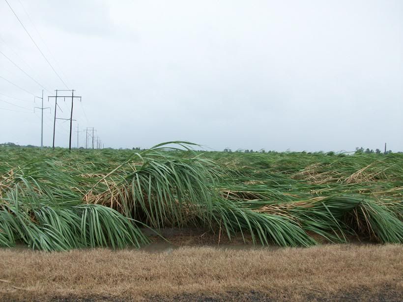
During a lull in the rain yesterday, I went down to check on our camp. There was a lot of flattened sugarcane and flooded fields. Some of the bayous and canals around White Castle, LA were the highest I can remember seeing. Waiting to see how high the Grand River gets now. Alligator season should be open. Wonder if Lee will get mentioned in the next season of Swamp People? I did not see much tree damage down in Pigeon, either in the Spillway or on HWY 75, but that was yesterday. Today's winds seem to have been much stronger.
0 likes
Re: ATL: LEE - Tropical Storm - Discussion
wxman57 wrote:pwrdog wrote:What is going on with this storm.
It wrapped around itself and slung a huge piece of moisture down into the southern gulf of mexico and now it seems detached..
It also threw a huge piece off towards the east and detached from that..
I've been watching the storms for 30 years and have never seen one like this one..
I wonder if something will develope down south now once the front stalls to it's north.... I'm perplexed..
Most complex tropical system I've ever seen..
Oh, And it swallowed a upper low and a piece of dry air that is still near the center..
Lee is more of a subtropical cyclone than a tropical storm. Very common appearance. Large wind field but no intense winds, few squalls near the center. Dry air influx from the west isn't helping.
Very common.. What? I think you missed my point about Lee.... Not talking about large windfield and no intense core winds...
0 likes
-
JonathanBelles
- Professional-Met

- Posts: 11430
- Age: 35
- Joined: Sat Dec 24, 2005 9:00 pm
- Location: School: Florida State University (Tallahassee, FL) Home: St. Petersburg, Florida
- Contact:
Re: ATL: LEE - Tropical Storm - Discussion
Before and after pictures from Tallahassee and the Capitol building as the squall line passed:


0 likes
Re: ATL: LEE - Tropical Storm - Discussion
vbhoutex wrote:Turtle wrote:I live along I-20 in East Texas and just got a 43 MPH gust. Some of my potted plants have been knocked over!
It has been quite windy here in Houston but I haven't seen any rain, at least on the West side. Gusts have been to 37 mph which I find strange considering how far W of the center we are.

Gusts to 44 mph here in Austin (airport). Local news says it's Lee but ...
0 likes
-
southerngale

- Retired Staff

- Posts: 27418
- Joined: Thu Oct 10, 2002 1:27 am
- Location: Southeast Texas (Beaumont area)
Re: ATL: LEE - Tropical Storm - Discussion
Shoshana wrote:vbhoutex wrote:Turtle wrote:I live along I-20 in East Texas and just got a 43 MPH gust. Some of my potted plants have been knocked over!
It has been quite windy here in Houston but I haven't seen any rain, at least on the West side. Gusts have been to 37 mph which I find strange considering how far W of the center we are.
Gusts to 44 mph here in Austin (airport). Local news says it's Lee but ...
Yesterday, several KFDM Instaweather (Weatherbug) stations reported winds in the 40s in Beaumont and down to Sabine Pass. The highest ones I saw were 48mph and 49mph, in South Beaumont and Sabine Pass. All stations that I checked had gusts at least in the 30s. It was windy/breezy all day.
0 likes
Please support Storm2k by making a donation today. It is greatly appreciated! Click here: 
 my Cowboys my Rockets my Astros
my Cowboys my Rockets my AstrosWho is online
Users browsing this forum: No registered users and 10 guests