PTrackerLA wrote:Latest NAM has leave pushing WSW from current location and then south as it intensifies into a hurricane!
http://mag.ncep.noaa.gov/NCOMAGWEB/appc ... mageSize=M
NAM on drugs!!!
Moderator: S2k Moderators

PTrackerLA wrote:Latest NAM has leave pushing WSW from current location and then south as it intensifies into a hurricane!
http://mag.ncep.noaa.gov/NCOMAGWEB/appc ... mageSize=M
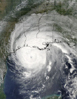
wxman57 wrote:One thing to keep in mind with Lee is that it's not a typically-structured tropical storm. There are no heavy squalls near the center, and strongest winds are far-removed from the center out over the Gulf off the southeast LA coast. As it moves inland, the tropical storm force winds will remain offshore. They won't be around Lee's center. It's that band of squalls extending southward from southeast LA out across the Gulf that has the TS winds (over water).
Latest recon doesn't seem to be finding any surface evidence of 60 mph winds. Strongest winds in actual surface obs are way east near the mouth of the MS River - about 40-45 kts.
PTrackerLA wrote:I know this isn't models thread (but that thread is dead) so check out the latest NAM at 54 hrs. Moves Lee WSW then south and intensifies into a hurricane as another piece of energy from LEE is heading up into the mid atlanta. Crazy.
http://img192.imageshack.us/img192/2011 ... precip.gif


Tireman4 wrote:I am looking at the radar. Now, I am dumber than a box of rocks, but I swear the rainbands are moving west. I swear I am seeing a whole bunch of something heading our way. Now, I am sure I am wrong.
http://www.srh.noaa.gov/hgx/


pwrdog wrote:Tireman4 wrote:I am looking at the radar. Now, I am dumber than a box of rocks, but I swear the rainbands are moving west. I swear I am seeing a whole bunch of something heading our way. Now, I am sure I am wrong.
http://www.srh.noaa.gov/hgx/
They are expanding that way.... just how long that will continue is the big question... That dry slot might try and cut this thing in half?????????
cycloneye wrote:SUMMARY OF 1000 AM CDT...1500 UTC...INFORMATION
-----------------------------------------------
LOCATION...29.3N 91.8W
ABOUT 45 MI...75 KM SW OF MORGAN CITY LOUISIANA
ABOUT 65 MI...100 KM S OF LAFAYETTE LOUISIANA
MAXIMUM SUSTAINED WINDS...60 MPH...95 KM/H
PRESENT MOVEMENT...N OR 5 DEGREES AT 6 MPH...9 KM/H
MINIMUM CENTRAL PRESSURE...993 MB...29.32 INCHES

Dean4Storms wrote:cycloneye wrote:SUMMARY OF 1000 AM CDT...1500 UTC...INFORMATION
-----------------------------------------------
LOCATION...29.3N 91.8W
ABOUT 45 MI...75 KM SW OF MORGAN CITY LOUISIANA
ABOUT 65 MI...100 KM S OF LAFAYETTE LOUISIANA
MAXIMUM SUSTAINED WINDS...60 MPH...95 KM/H
PRESENT MOVEMENT...N OR 5 DEGREES AT 6 MPH...9 KM/H
MINIMUM CENTRAL PRESSURE...993 MB...29.32 INCHES
Very strange, I don't a north movement on radar at all, if anything a drift south.


Users browsing this forum: No registered users and 23 guests
