The Name That Storm game, series III
Moderator: S2k Moderators
Forum rules

The posts in this forum are NOT official forecasts and should not be used as such. They are just the opinion of the poster and may or may not be backed by sound meteorological data. They are NOT endorsed by any professional institution or STORM2K. For official information, please refer to products from the National Hurricane Center and National Weather Service.

Re: (Slightly OT, but tropics fun!) Name that storm, Mark III
I think that's Frances 1998. I remember getting flooded out at UNO and getting my truck stuck on a parking lot timber and wading through flood waters barefoot.
0 likes


Re: (Slightly OT, but tropics fun!) Name that storm, Mark III
I will take a jab and say it is Allison from 2001.
0 likes
Re: (Slightly OT, but tropics fun!) Name that storm, Mark III
Ptarmigan wrote:I will take a jab and say it is Allison from 2001.
And you'd be right. That's Allison nearing LA landfall.
---
Leaderboard:
poof121 - 2
Cainer - 1
Ptarmigan - 1
0 likes
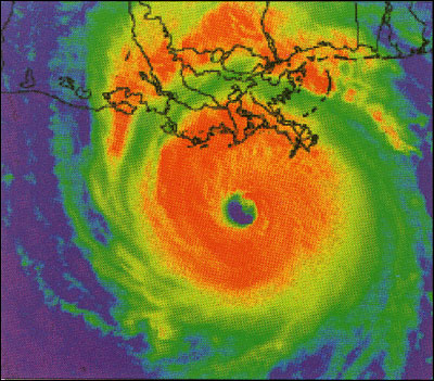
Here's another advisory...
...EYE OF HURRICANE ??? NEARING THE COAST...
TIDES UP TO 15 FEET EXPECTED NEAR AND JUST NORTH OF
LANDFALL AREA.
HURRICANE WARNINGS REMAIN IN EFFECT FROM THE TEXAS COAST
SOUTH OF FREEPORT TO BROWNSVILLE.
GALE WARNINGS REMAIN IN EFFECT FREEPORT TO VERMILION BAY.
HURRICANE CONDITIONS ARE SPREADING INTO NORTHEAST
MEXICO.
RECOMMENDATIONS REGARDING SPECIFIC ACTIONS INCLUDING
EVACUATION ADVICE ARE CONTAINED IN LOCAL STATEMENTS BEING
ISSUED BY WEATHER SERVICE OFFICES AND LOCAL GOVERNMENT
OFFICIALS IN THE WARNING AREA.
TIDES OF 15 FEET ABOVE NORMAL ARE EXPECTED NEAR AND
JUST NORTH OF THE CENTER WHEN IT MAKES LANDFALL.
ELSEWHERE IN THE HURRICANE WARNING AREA TIDES WILL
BE 5 TO 7 FEET ABOVE NORMAL.
0 likes


Re: (Slightly OT, but tropics fun!) Name that storm, Mark III
Got a hurricane headed into southern Texas before 1987 (when Tropical storm warnings replaced gale warnings). My best guess is Allen.
0 likes
Re: (Slightly OT, but tropics fun!) Name that storm, Mark III
BigA wrote:Got a hurricane headed into southern Texas before 1987 (when Tropical storm warnings replaced gale warnings). My best guess is Allen.
First one to guess correctly on the first try!
poof121 - 1
Cainer - 1
Ptarmigan - 1
BigA - 1
Now, I'd like to have a go at guessing too, anyone else wanna post one?
0 likes
-
Battlebrick
- Tropical Storm

- Posts: 177
- Joined: Thu Sep 02, 2010 9:55 pm
Re: (Slightly OT, but tropics fun!) Name that storm, Mark III
easy one

one of the best looking cyclones ever
one of the best looking cyclones ever
0 likes
Lim_Fao on IRC.
The following post is NOT an official forecast and should not be used as such. It is just the opinion of the poster and may or may not be backed by sound meteorological data. It is NOT endorsed by any professional institution including storm2k.org. For Official Information please refer to the NHC and NWS products.
The following post is NOT an official forecast and should not be used as such. It is just the opinion of the poster and may or may not be backed by sound meteorological data. It is NOT endorsed by any professional institution including storm2k.org. For Official Information please refer to the NHC and NWS products.
-
Battlebrick
- Tropical Storm
- Posts: 177
- Joined: Thu Sep 02, 2010 9:55 pm
Re:
Chacor wrote:Indeed, ADT Dvorak estimates were CI T8.0, absolutely incredible. Cyclone Monica was a beast.
i wouldn't be surprised if Monica beat Tip in terms of pressure (but some other storms in the WPAC could have also beat Tip, lack of recon ftl).
but yeah, correct.
0 likes
Lim_Fao on IRC.
The following post is NOT an official forecast and should not be used as such. It is just the opinion of the poster and may or may not be backed by sound meteorological data. It is NOT endorsed by any professional institution including storm2k.org. For Official Information please refer to the NHC and NWS products.
The following post is NOT an official forecast and should not be used as such. It is just the opinion of the poster and may or may not be backed by sound meteorological data. It is NOT endorsed by any professional institution including storm2k.org. For Official Information please refer to the NHC and NWS products.
-
Annie Oakley

- Category 5

- Posts: 1103
- Joined: Tue Jul 31, 2007 12:54 pm
- Location: Texas
-
Battlebrick
- Tropical Storm
- Posts: 177
- Joined: Thu Sep 02, 2010 9:55 pm
Re:
Annie Oakley wrote:I think the image had a few huge hints.....do another one Battle.
NOT to take away from you Chacor...I fully believe you know your cane history yeah!
yeah, i guess it was pretty easy.
a little harder..
0 likes
Lim_Fao on IRC.
The following post is NOT an official forecast and should not be used as such. It is just the opinion of the poster and may or may not be backed by sound meteorological data. It is NOT endorsed by any professional institution including storm2k.org. For Official Information please refer to the NHC and NWS products.
The following post is NOT an official forecast and should not be used as such. It is just the opinion of the poster and may or may not be backed by sound meteorological data. It is NOT endorsed by any professional institution including storm2k.org. For Official Information please refer to the NHC and NWS products.
Re:
djones65 wrote:That is Hurricane Andrew in 1992 approaching second landfall in LA.
http://pubs.usgs.gov/fs/hurricane-impac ... /fig1.html
That page says you are correct.
poof121 - 2
Cainer - 1
Ptarmigan - 1
BigA - 1
Chacor - 1
djones65 - 1
---
Name the storm:
A HURRICANE WATCH AND GALE WARNINGS ARE IN EFFECT FROM FREEPORT
TEXAS EASTWARD TO MORGAN CITY LOUISIANA AND GALE WARNINGS EXTEND
EAST TO THE MOUTH OF THE MISSISSIPPI RIVER. GALE WARNINGS AND THE
HURRICANE WATCH ARE DISCONTINUED SOUTH OF FREEPORT. ELSEWHERE...
SMALL CRAFT FROM BROWNSVILLE TO BILOXI SHOULD STAY IN PORT.
AT 9 PM CDT...0200Z...??? WAS CENTERED NEAR LATITUDE 28.5 NORTH
...LONGITUDE 94.0 WEST...OR ABOUT 125 MILES SOUTH SOUTHWEST OF LAKE
CHARLES LOUISIANA. THE STORM IS NOW MOVING NORTHWARD AT ABOUT 5 MPH
AND THIS MOVEMENT...WITH A POSSIBLE INCREASE IN FORWARD SPEED...WILL
BRING THE CENTER ACROSS THE SOUTHWEST LOUISIANA OR UPPER TEXAS COAST
ON SATURDAY MORNING.
0 likes
-
Annie Oakley
- Category 5
- Posts: 1103
- Joined: Tue Jul 31, 2007 12:54 pm
- Location: Texas
(changing my answer while no-one is looking ) 
Bertha?
Bertha?
Last edited by Annie Oakley on Wed Aug 31, 2011 7:57 am, edited 1 time in total.
0 likes
-
Annie Oakley
- Category 5
- Posts: 1103
- Joined: Tue Jul 31, 2007 12:54 pm
- Location: Texas

Who is online
Users browsing this forum: Ulf, WaveBreaking and 227 guests