GCANE wrote:http://www.youtube.com/watch?v=3hVfVxSYPxM
im listining to 810 AM from the Bahamas on the radio, sounds like most places plan on being open for business tomorrow morning
Moderator: S2k Moderators

GCANE wrote:http://www.youtube.com/watch?v=3hVfVxSYPxM

Aric Dunn wrote:for all intensive purposes... SF should have had TS watches and well warnings put up.. being that well there is a whole lot of convection coming with TS force winds.. lol bad call by NHC in my own opinion ..


CrazyC83 wrote:jhpigott wrote:NDG wrote:Wow, 50 knot wind gust so far at Jupiter Inlet this morning, where are the Tropical Storm Warnings for at least the immediate coast!
http://www.evsjupiter.com/weather/summary.gif
what does 53knots equate to in mph?
58 kt = about 67 mph.
dolebot_Broward_NW wrote:Aric Dunn wrote:for all intensive purposes... SF should have had TS watches and well warnings put up.. being that well there is a whole lot of convection coming with TS force winds.. lol bad call by NHC in my own opinion ..
I don't see the point of that. None of the winds are sustained, and TS force winds are miles away.
http://www.ndbc.noaa.gov/radial_search. ... t=A&time=3
Here is the answer to "what are the winds like in the bands offshore?" 25kts at lake worth inlet give or take. Also the current storms racing west to the everglades aren't hurricane related, they are boundary storms! (i.e. typical seabreeze style forcing). Now the cane is out there blowing but these storms winds don't come from the storm, they are convective along a line here. All the winds i'm seeing are squally and not very impressive. No reason to engage local emergency offices, roust the ham radio ops out of bed, or start planning to bring supplies in, when there is no danger to anyone.
deltadog03 wrote:She doesn't look too good this am.


ConvergenceZone wrote:deltadog03 wrote:She doesn't look too good this am.
Yea, I'm starting to think that her intensification phase is over with. Conditions are far from idea now, so in my opinion, she could be on the decline strength wise from here. She might still be a hurricane though as she moves up north towards the north coast.
CrazyC83 wrote:jhpigott wrote:NDG wrote:Wow, 50 knot wind gust so far at Jupiter Inlet this morning, where are the Tropical Storm Warnings for at least the immediate coast!
http://www.evsjupiter.com/weather/summary.gif
what does 53knots equate to in mph?
58 kt = about 67 mph.

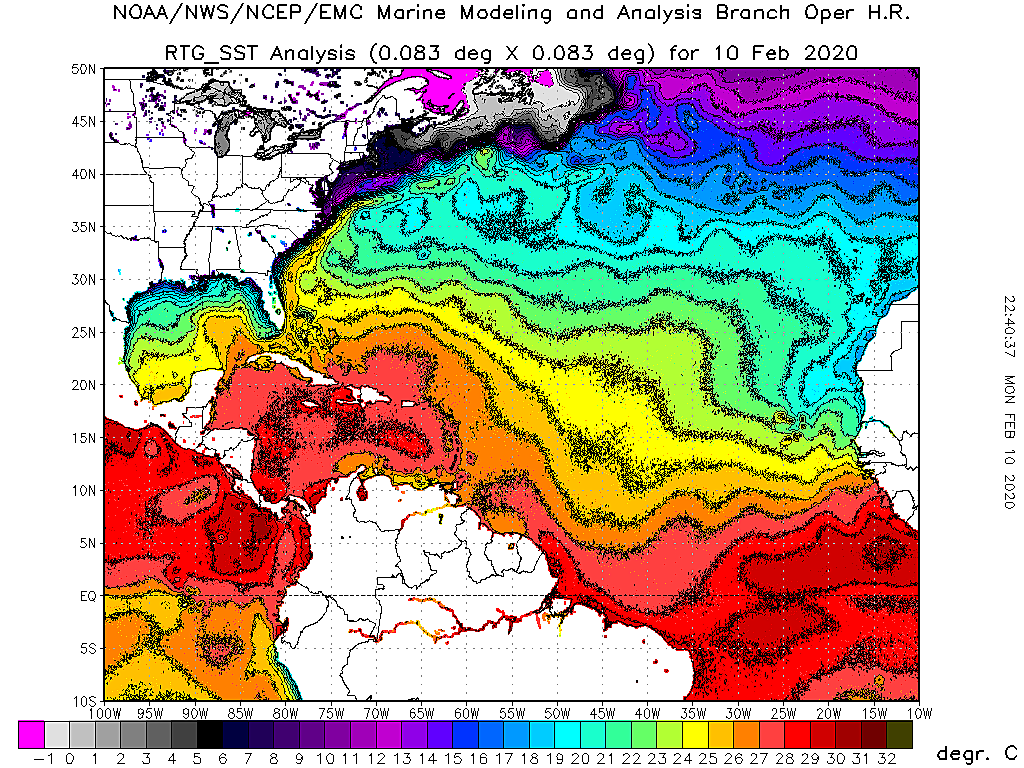
wxman57 wrote:Anyone here have a good link for a high-res SST map of the East U.S. Coast?
wxman57 wrote:Anyone here have a good link for a high-res SST map of the East U.S. Coast?
Users browsing this forum: No registered users and 10 guests


