ATL: IRENE - Remnants - Discussion

Moderator: S2k Moderators

Message
Author
User avatar
CronkPSU
S2K Supporter
S2K Supporter
Posts: 2020
Joined: Sun Aug 07, 2005 10:44 pm
Location: Avalon Park, FL

Re: ATL: IRENE - Hurricane - Discussion

#5301 Postby CronkPSU » Wed Aug 24, 2011 7:57 am

sandyb wrote:Can someone explain to me why our local met on tv is saying he thinks the models are over doing the eastward track and he thinks tomorrow that the models will be back to the west over us here in NC


he doesn't think the trough is as strong as the models and that the high pressure ridge will remain strong enough that a NNW motion will continue and not a N motion would be my guess
0 likes   

RL3AO
Moderator-Pro Met
Moderator-Pro Met
Posts: 16308
Joined: Thu Jun 14, 2007 10:03 pm
Location: NC

#5302 Postby RL3AO » Wed Aug 24, 2011 7:59 am

982
URNT15 KWBC 241253
NOAA2 1309A IRENE HDOB 28 20110824
124330 2207N 07322W 7520 02113 9547 +203 +141 174033 036 037 001 00
124400 2207N 07320W 7520 02118 9556 +195 +152 184046 053 049 005 03
124430 2207N 07318W 7514 02144 9591 +172 +167 188080 088 086 007 00
124500 2207N 07316W 7486 02212 9639 +160 +161 186107 113 094 008 00
124530 2207N 07314W 7502 02234 9689 +154 +158 183112 114 088 012 00
124600 2207N 07312W 7507 02261 9724 +154 //// 177108 110 085 016 01
124630 2207N 07310W 7518 02275 9757 +149 //// 174103 106 068 043 05
124700 2207N 07308W 7487 02327 9779 +146 //// 173102 104 062 039 01
124730 2207N 07307W 7538 02292 9805 +146 //// 177098 099 069 020 01
124800 2207N 07305W 7504 02344 9814 +144 //// 177096 100 068 013 01
124830 2207N 07303W 7500 02362 9835 +145 //// 177093 094 067 014 01
124900 2207N 07301W 7513 02357 9849 +144 +149 179097 100 065 009 00
124930 2207N 07259W 7510 02373 9857 +149 +145 179088 090 066 007 00
125000 2207N 07257W 7527 02363 9870 +146 +150 179081 083 067 012 00
125030 2207N 07255W 7526 02374 9882 +143 //// 178084 087 066 015 01
125100 2207N 07253W 7505 02404 9897 +136 //// 175079 081 062 009 01
125130 2207N 07251W 7522 02394 9905 +140 +137 174074 074 061 008 00
125200 2207N 07249W 7527 02394 9914 +137 //// 174073 075 061 010 01
125230 2207N 07247W 7520 02410 9928 +131 //// 173078 082 060 009 01
125300 2207N 07245W 7509 02427 9936 +130 +129 165079 080 059 010 00

114kts FL
0 likes   

User avatar
BigA
Professional-Met
Professional-Met
Posts: 1317
Joined: Sun Jul 24, 2005 10:56 pm

Re: ATL: IRENE - Hurricane - Discussion

#5303 Postby BigA » Wed Aug 24, 2011 7:59 am

hurricaneCW wrote:I really think were the models are now is the furthest east this thing could go, there's not a huge trough turning this away like there was with Earl, I think we may very well see shifts back west later today or tonight.


It would be awesome if a pro or knowledgeable non-pro could explain the synoptic differences (and similarities) between the set up with Earl and the setup with Irene.
0 likes   

sandyb
Tropical Storm
Tropical Storm
Posts: 221
Age: 64
Joined: Thu Jul 12, 2007 3:09 pm

Re: ATL: IRENE - Hurricane - Discussion

#5304 Postby sandyb » Wed Aug 24, 2011 7:59 am

CronkPSU wrote:
sandyb wrote:Can someone explain to me why our local met on tv is saying he thinks the models are over doing the eastward track and he thinks tomorrow that the models will be back to the west over us here in NC


he doesn't think the trough is as strong as the models and that the high pressure ridge will remain strong enough that a NNW motion will continue and not a N motion would be my guess


could he be right or is he just jumping the gun to make sure we all stay in tune with whats going on
0 likes   
CARTERET COUNTY NC

RL3AO
Moderator-Pro Met
Moderator-Pro Met
Posts: 16308
Joined: Thu Jun 14, 2007 10:03 pm
Location: NC

#5305 Postby RL3AO » Wed Aug 24, 2011 7:59 am

114kt FL east eyewall
0 likes   

User avatar
littlevince
S2K Supporter
S2K Supporter
Posts: 768
Joined: Fri Oct 21, 2005 10:45 am
Location: Portugal

Re: ATL: IRENE - Recon

#5306 Postby littlevince » Wed Aug 24, 2011 8:01 am

Image
0 likes   

Deputy Van Halen
Tropical Storm
Tropical Storm
Posts: 104
Joined: Thu Aug 03, 2006 12:00 am
Location: Texas City, TX

Re: ATL: IRENE - Hurricane - Discussion

#5307 Postby Deputy Van Halen » Wed Aug 24, 2011 8:02 am

As a statistician (of sorts), this continual "eastward trend" of the past couple days bugs me.

If each forecast track is the best estimate at the time of the advisory, the next advisory should have about the same likelihood of shifting west as of shifting east again.

It almost makes me wonder if they shift the track gradually, rather than all at once, so as to give a sense of continuity and not confuse people with wildly erratic forecasts. Or more cynically, to not give casual observers the impression that they're clueless or incompetent.
0 likes   

sandyb
Tropical Storm
Tropical Storm
Posts: 221
Age: 64
Joined: Thu Jul 12, 2007 3:09 pm

Re: ATL: IRENE - Hurricane - Discussion

#5308 Postby sandyb » Wed Aug 24, 2011 8:04 am

Deputy Van Halen wrote:As a statistician (of sorts), this continual "eastward trend" of the past couple days bugs me.

If each forecast track is the best estimate at the time of the advisory, the next advisory should have about the same likelihood of shifting west as of shifting east again.

It almost makes me wonder if they shift the track gradually, rather than all at once, so as to give a sense of continuity and not confuse people with wildly erratic forecasts. Or more cynically, to not give casual observers the impression that they're clueless or incompetent.


i agree! :sun: :sun:
0 likes   
CARTERET COUNTY NC

RL3AO
Moderator-Pro Met
Moderator-Pro Met
Posts: 16308
Joined: Thu Jun 14, 2007 10:03 pm
Location: NC

#5309 Postby RL3AO » Wed Aug 24, 2011 8:04 am

482
URNT15 KNHC 241302
AF303 1409A IRENE HDOB 25 20110824
125230 2113N 07230W 6966 03097 //// +089 //// 201056 057 /// /// 05
125300 2114N 07231W 6968 03092 //// +090 //// 204058 060 /// /// 05
125330 2116N 07233W 6967 03092 //// +090 //// 205058 060 /// /// 05
125400 2117N 07234W 6967 03087 //// +090 //// 207057 058 /// /// 05
125430 2118N 07236W 6967 03088 //// +085 //// 206056 058 /// /// 05
125500 2120N 07237W 6967 03086 //// +091 //// 209052 054 /// /// 05
125530 2121N 07238W 6968 03084 //// +089 //// 207051 054 /// /// 05
125600 2122N 07240W 6965 03084 //// +090 //// 208051 053 /// /// 05
125630 2124N 07241W 6968 03080 //// +089 //// 208054 055 /// /// 05
125700 2125N 07243W 6961 03081 //// +095 //// 207052 053 /// /// 05
125730 2126N 07244W 6967 03071 //// +098 //// 208050 051 /// /// 05
125800 2128N 07245W 6967 03071 //// +101 //// 208049 050 /// /// 05
125830 2129N 07247W 6963 03074 //// +102 //// 202050 051 /// /// 05
125900 2130N 07248W 6967 03067 //// +103 //// 201051 051 /// /// 05
125930 2132N 07250W 6958 03074 //// +089 //// 196056 059 /// /// 05
130000 2133N 07251W 6967 03059 //// +082 //// 200056 057 /// /// 05
130030 2134N 07253W 6973 03045 //// +103 //// 206059 061 /// /// 05
130100 2136N 07254W 6965 03053 //// +100 //// 206061 062 /// /// 05
130130 2137N 07255W 6969 03045 //// +099 //// 203060 061 /// /// 05
130200 2139N 07257W 6965 03044 //// +099 //// 203061 062 /// /// 05
$$
;
0 likes   

User avatar
CronkPSU
S2K Supporter
S2K Supporter
Posts: 2020
Joined: Sun Aug 07, 2005 10:44 pm
Location: Avalon Park, FL

Re: ATL: IRENE - Hurricane - Discussion

#5310 Postby CronkPSU » Wed Aug 24, 2011 8:05 am

sandyb wrote:
CronkPSU wrote:
sandyb wrote:Can someone explain to me why our local met on tv is saying he thinks the models are over doing the eastward track and he thinks tomorrow that the models will be back to the west over us here in NC


he doesn't think the trough is as strong as the models and that the high pressure ridge will remain strong enough that a NNW motion will continue and not a N motion would be my guess


could he be right or is he just jumping the gun to make sure we all stay in tune with whats going on


We don't know yet...i think he may be right but the nhc is usually pretty good three days and less
0 likes   

emeraldislencguy
S2K Supporter
S2K Supporter
Posts: 207
Joined: Sun Aug 27, 2006 4:35 pm
Location: emerald isle nc
Contact:

Re: ATL: IRENE - Hurricane - Discussion

#5311 Postby emeraldislencguy » Wed Aug 24, 2011 8:06 am

he is a very good and caring weatherman
he doenst care avout ratings but really cares about his viewers
dont thk he is jumping the gun but just trying to give us a heads up just in case the storm jogs to the west-
he doesnt think the front will be as strong as they are indicating it to be'
skip has been on tv 12 a long time and he is a great weatherman and doenst have to plug his ratings
0 likes   

RL3AO
Moderator-Pro Met
Moderator-Pro Met
Posts: 16308
Joined: Thu Jun 14, 2007 10:03 pm
Location: NC

#5312 Postby RL3AO » Wed Aug 24, 2011 8:06 am

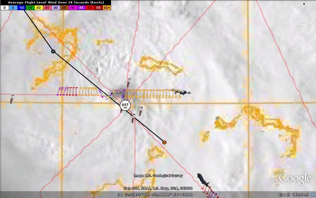
Hey vince, can you turn off some of the previous obs. It gets kind of messy with two planes in such a slow moving system.

Image
0 likes   

Aric Dunn
Category 5
Category 5
Posts: 21238
Age: 43
Joined: Sun Sep 19, 2004 9:58 pm
Location: Ready for the Chase.
Contact:

Re: ATL: IRENE - Hurricane - Discussion

#5313 Postby Aric Dunn » Wed Aug 24, 2011 8:06 am

Deputy Van Halen wrote:As a statistician (of sorts), this continual "eastward trend" of the past couple days bugs me.

If each forecast track is the best estimate at the time of the advisory, the next advisory should have about the same likelihood of shifting west as of shifting east again.

It almost makes me wonder if they shift the track gradually, rather than all at once, so as to give a sense of continuity and not confuse people with wildly erratic forecasts. Or more cynically, to not give casual observers the impression that they're clueless or incompetent.


haha.. of course they do. human analysis and experience will out do a model in that sense. dont think its to confuse people more they realize models have no ability to judge minute by minute the surroundings.
0 likes   
Note: If I make a post that is brief. Please refer back to previous posts for the analysis or reasoning. I do not re-write/qoute what my initial post said each time.
If there is nothing before... then just ask :)

Space & Atmospheric Physicist, Embry-Riddle Aeronautical University,
I believe the sky is falling...

RL3AO
Moderator-Pro Met
Moderator-Pro Met
Posts: 16308
Joined: Thu Jun 14, 2007 10:03 pm
Location: NC

Re: ATL: IRENE - Recon

#5314 Postby RL3AO » Wed Aug 24, 2011 8:08 am

567
URNT12 KWBC 241254
VORTEX DATA MESSAGE
A. 24/1046Z
B. 21 DEG 50 MIN N
73 DEG 14 MIN W
C. NA
D. 81 KT
E. 336 DEG 10 NM
F. 068 DEG 95 KT
G. 339 DEG 10 NM
H. 957 MB
I. 14 C/2440 M
J. 20 C/2443 M

K. 14 C/NA
L. CLOSED WALL
M. E09/20/15
N. 12345/NA
O. 1/1 NM
P. NOAA2 1309A IRENE OB 19 AL092011
OUTBOUND MAX FL WIND 86kts qUAD 1049Z
SEOND MAX FL WIND INBOUND 87KTS 001/71NM
0 likes   

jhpigott
Category 2
Category 2
Posts: 574
Joined: Wed Jan 02, 2008 8:09 pm
Location: North Palm Beach, Florida

Re: ATL: IRENE - Hurricane - Discussion

#5315 Postby jhpigott » Wed Aug 24, 2011 8:09 am

deltadog03 wrote:
sandyb wrote:Can someone explain to me why our local met on tv is saying he thinks the models are over doing the eastward track and he thinks tomorrow that the models will be back to the west over us here in NC


IDK...Personal opinion??? All of the tracks (models) along or just east of the outer banks. Is it possible that this comes closer to you....ya sure, but likely not really.....All about timing. She will move quicker today, with the ridge having built back in (TEMP) Hope that helps


Delta - would the ridge building back in (at least for the short term) induce a little more of a westerly component for the short term? I recognize this is going to stay to our east here in SEFL, but could this ridge potentially send Irene thru Grand Bahama island rather than the Abacos?
0 likes   

RL3AO
Moderator-Pro Met
Moderator-Pro Met
Posts: 16308
Joined: Thu Jun 14, 2007 10:03 pm
Location: NC

#5316 Postby RL3AO » Wed Aug 24, 2011 8:09 am

157
URNT15 KWBC 241303
NOAA2 1309A IRENE HDOB 29 20110824
125330 2207N 07243W 7510 02431 9945 +127 +128 164077 078 056 013 00
125400 2207N 07241W 7504 02443 9950 +127 +129 165076 076 056 014 00
125430 2207N 07240W 7531 02418 9951 +132 +131 168074 074 054 011 00
125500 2207N 07238W 7529 02423 9953 +134 +134 168072 073 051 008 00
125530 2207N 07236W 7500 02458 9949 +138 +136 174072 075 053 015 03
125600 2207N 07234W 7486 02474 9947 +139 //// 174073 077 059 010 01
125630 2207N 07232W 7502 02460 9957 +137 +137 176073 076 056 010 00
125700 2207N 07230W 7509 02457 9963 +135 +140 178076 080 056 009 00
125730 2207N 07228W 7522 02444 9963 +137 //// 178077 081 056 009 01
125800 2207N 07226W 7517 02455 9968 +138 +139 172065 067 056 009 00
125830 2207N 07224W 7506 02472 9977 +135 +131 169067 067 054 009 00
125900 2207N 07222W 7534 02445 9984 +132 +136 170067 067 053 008 00
125930 2207N 07220W 7519 02465 9987 +133 //// 170064 066 052 007 01
130000 2207N 07218W 7517 02470 9988 +134 //// 171067 069 049 011 01
130030 2207N 07216W 7520 02469 9991 +136 +140 169061 062 050 012 00
130100 2207N 07214W 7501 02492 9996 +131 //// 167055 061 049 017 01
130130 2207N 07212W 7503 02490 0000 +128 //// 171052 054 049 013 01
130200 2207N 07210W 7494 02500 9999 +128 //// 170064 069 054 023 01
130230 2207N 07208W 7561 02425 9992 +139 +140 171069 072 057 018 00
130300 2207N 07206W 7543 02449 0004 +130 //// 168072 077 052 015 01
0 likes   

User avatar
CronkPSU
S2K Supporter
S2K Supporter
Posts: 2020
Joined: Sun Aug 07, 2005 10:44 pm
Location: Avalon Park, FL

Re: ATL: IRENE - Hurricane - Discussion

#5317 Postby CronkPSU » Wed Aug 24, 2011 8:11 am

aric-what are your thoughts this morning? ridge still holding strong for how long? still looking at the outer banks for a hit?
0 likes   

User avatar
littlevince
S2K Supporter
S2K Supporter
Posts: 768
Joined: Fri Oct 21, 2005 10:45 am
Location: Portugal

Re: ATL: IRENE - Recon

#5318 Postby littlevince » Wed Aug 24, 2011 8:12 am

done

Image
0 likes   

User avatar
viberama
Tropical Depression
Tropical Depression
Posts: 65
Age: 53
Joined: Mon Aug 01, 2011 7:36 pm
Location: Orlando, FL
Contact:

Re: ATL: IRENE - Hurricane - Discussion

#5319 Postby viberama » Wed Aug 24, 2011 8:14 am

My personal opinion is the ridge building back in temporarily won't change anything. The great lakes trough will errode the ridge soon enough and the track won't change at all. It might even move the track father east.
0 likes   
The following post is NOT an official forecast and should not be used as such. It is just my opinion and may or may not be backed by sound meteorological data. For Official Information please refer to the NHC and NWS products

RL3AO
Moderator-Pro Met
Moderator-Pro Met
Posts: 16308
Joined: Thu Jun 14, 2007 10:03 pm
Location: NC

Re: ATL: IRENE - Hurricane - Discussion

#5320 Postby RL3AO » Wed Aug 24, 2011 8:15 am

Image

Hmm. Hints of a 2nd eyewall forming or just a poorly organized core?
0 likes   


Return to “2011”

Who is online

Users browsing this forum: No registered users and 9 guests