ATL: IRENE - Remnants - Discussion

Moderator: S2k Moderators

Message
Author
User avatar
weatherwindow
Category 4
Category 4
Posts: 904
Joined: Mon Sep 20, 2004 9:48 am
Location: key west/ft lauderdale

Re: ATL: IRENE - Tropical Storm - Discussion

#1761 Postby weatherwindow » Sun Aug 21, 2011 8:16 am

tolakram wrote:
weatherwindow wrote:can someone provide a detailed map of the northeastern carib inclluding the BVI, VI and the rest of the leewards north of guadeloupe?......thanks, rich


Google maps is pretty good.

http://maps.google.com/maps?hl=en&ll=16 ... =8&vpsrc=6

thanks
0 likes   

tolakram
Admin
Admin
Posts: 20012
Age: 62
Joined: Sun Aug 27, 2006 8:23 pm
Location: Florence, KY (name is Mark)

Re:

#1762 Postby tolakram » Sun Aug 21, 2011 8:17 am

Aric Dunn wrote:she is in view of the east conus sat. already in rapid scan mode :)

http://weather.msfc.nasa.gov/GOES/goeseastconus.html


Live LOOP: http://wwwghcc.msfc.nasa.gov/cgi-bin/ge ... umframes=5
0 likes   
M a r k
- - - - -
Join us in chat: Storm2K Chatroom Invite. Android and IOS apps also available.

The posts in this forum are NOT official forecasts and should not be used as such. Posts are NOT endorsed by any professional institution or STORM2K.org. For official information and forecasts, please refer to NHC and NWS products.

User avatar
Blown Away
S2K Supporter
S2K Supporter
Posts: 10152
Joined: Wed May 26, 2004 6:17 am

Re:

#1763 Postby Blown Away » Sun Aug 21, 2011 8:17 am

Aric Dunn wrote:she is in view of the east conus sat. already in rapid scan mode :)

http://weather.msfc.nasa.gov/GOES/goeseastconus.html


Please give a Lat/Long.
0 likes   
Hurricane Eye Experience: David 79, Irene 99, Frances 04, Jeanne 04, Wilma 05... EYE COMING MY WAY IN 2024…
Hurricane Brush Experience: Andrew 92, Erin 95, Floyd 99, Matthew 16, Irma 17, Ian 22, Nicole 22…

jinftl
Category 5
Category 5
Posts: 4312
Joined: Tue Aug 31, 2004 4:47 pm
Location: fort lauderdale, fl

Re: ATL: IRENE - Tropical Storm - Discussion

#1764 Postby jinftl » Sun Aug 21, 2011 8:18 am

Every system that has been east of the U.S. East coast has recurved. Emily's track could be a foreshadow of something Irene might do plus or minus some longitude.

Image

Javlin wrote:I am thinking a more W movement is to ensue you look at this 24 link tand you see Harvey,sm.UUL and Irene in a line and everything is going W.In fact everything has been going W for weeks in this area with the exception of the occassional trof to do the lifting.

http://mapcenter.hamweather.com/satelli ... ?s=640x480
0 likes   

alch97
Tropical Low
Tropical Low
Posts: 26
Joined: Wed Sep 29, 2010 1:17 pm

Re: ATL: IRENE - Tropical Storm - Discussion

#1765 Postby alch97 » Sun Aug 21, 2011 8:18 am

Hi guys. I know we have all the models giving us ideas as to where the storm will go, but I want to ask all the folks here: what is your "gut" telling you where this storm may go?
0 likes   
I KNOW NOTHING.

Aric Dunn
Category 5
Category 5
Posts: 21238
Age: 42
Joined: Sun Sep 19, 2004 9:58 pm
Location: Ready for the Chase.
Contact:

Re: Re:

#1766 Postby Aric Dunn » Sun Aug 21, 2011 8:20 am

Blown Away wrote:
Aric Dunn wrote:she is in view of the east conus sat. already in rapid scan mode :)

http://weather.msfc.nasa.gov/GOES/goeseastconus.html


Please give a Lat/Long.


you just hit animate how many images.. I say like 15 and then click on the map it zooms for you..
0 likes   
Note: If I make a post that is brief. Please refer back to previous posts for the analysis or reasoning. I do not re-write/qoute what my initial post said each time.
If there is nothing before... then just ask :)

Space & Atmospheric Physicist, Embry-Riddle Aeronautical University,
I believe the sky is falling...

User avatar
Miami Storm Tracker
Category 4
Category 4
Posts: 910
Age: 67
Joined: Sun Jun 13, 2010 10:12 pm
Location: Key Largo, Fla.
Contact:

Re:

#1767 Postby Miami Storm Tracker » Sun Aug 21, 2011 8:20 am

RL3AO wrote:Its not an eye or eye like feature. Totally dry air. Remember guys, it only has a central pressure of 1006mb.


Thank you RL3AO I tried to reply to Aric for his reply but could not post it ffor some reason.
0 likes   

tolakram
Admin
Admin
Posts: 20012
Age: 62
Joined: Sun Aug 27, 2006 8:23 pm
Location: Florence, KY (name is Mark)

Re: ATL: IRENE - Recon

#1768 Postby tolakram » Sun Aug 21, 2011 8:21 am

Image
0 likes   
M a r k
- - - - -
Join us in chat: Storm2K Chatroom Invite. Android and IOS apps also available.

The posts in this forum are NOT official forecasts and should not be used as such. Posts are NOT endorsed by any professional institution or STORM2K.org. For official information and forecasts, please refer to NHC and NWS products.

Adoquín
Tropical Storm
Tropical Storm
Posts: 140
Joined: Thu Jul 28, 2011 8:47 pm

Re: ATL: IRENE - Tropical Storm - Discussion

#1769 Postby Adoquín » Sun Aug 21, 2011 8:22 am

cycloneye wrote:Good morning to all.

I have to give all the credit to Aric for his analysis of where the real center was last night. But that will cause that PR will be very much in the bulls eye if the current track prevails. You will not see me a lot today.


just woke up. Kudos to Aric. It is going to be a long day, unfortunately. I will try to send pics later should the lady permit.
0 likes   

rockyman
Category 5
Category 5
Posts: 1967
Joined: Thu Jun 26, 2003 12:24 pm
Location: Dauphin Island, AL

Re: ATL: IRENE - Tropical Storm - Discussion

#1770 Postby rockyman » Sun Aug 21, 2011 8:23 am

I learned a long time ago never to trust my guts...when it comes to the tropics. The cone has narrowed significantly since this time yesterday...with a track very close to the Florida Peninsula looking more and more likely (no central Gomex solutions any more)....I'd say somewhere between Apalachicola and Charleston, SC.
0 likes   

MiamiensisWx

Re: ATL: IRENE - Tropical Storm - Discussion

#1771 Postby MiamiensisWx » Sun Aug 21, 2011 8:23 am

MiamiensisWx wrote:The posts in this forum are NOT official forecast and should not be used as such. They are just the opinion of the poster and may or may not be backed by sound meteorological data. They are NOT endorsed by any professional institution or storm2k.org. For official information, please refer to the NHC and NWS products.

The 00Z ECMWF and the 06Z GFS reasonably concur as to track, with the ECMWF slightly slower and deeper through T+96. The models appear to differ as to the strength of Irene: in the next twenty-four hours before Hispaniola, the ECMWF shows significantly more intensification than does the GFS. The ECMWF in fact shows a minimal hurricane striking near Santo Domingo, whereas the GFS keeps a weaker, faster system farther southwest. Consequently, the ECMWF is, and has been, near the northern edge of the model consensus through T+36. This discrepancy is important to note, for Irene's intensity within 24hr should influence how much Irene interacts with the developing weakness in the subtropical ridge. Given Irene's relatively small inner core, I don't believe that the current mid-level dry air intrusion will exert significant influence beyond T+12, for the ridge to the north will erode somewhat due to falling heights off New England. If I were to make an informed guess, I would suggest a compromise between the ECMWF and the GFS as far as intensity is concerned.

The earlier, 00Z GFS forecast soundings for SJU, PR, show that the pronounced mid-level inversion will begin to erode about this time, and the latest 12Z sounding shows that this is indeed occurring, albeit slower than what the model had projected. Also, 
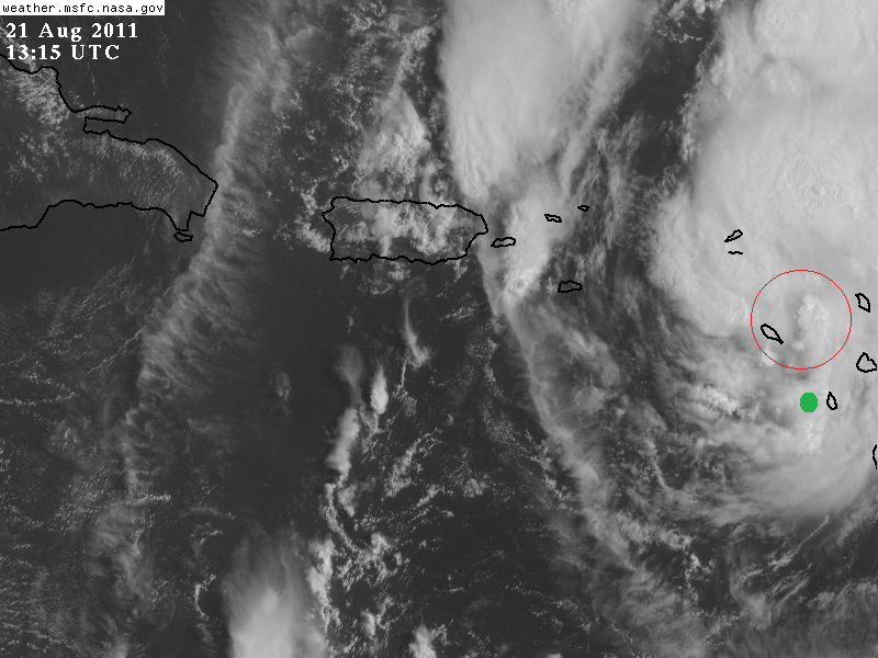
recent satellite images show a strong convective band developing on the north side of the mid-level circulation. I believe this is to be anticipated due to deepening moisture flux in the northern quadrant. As instability increases through the afternoon, I suspect that this convection will increase due to greater lifting, which will be facilitated by the weakening inversion. As a result, this band should begin to curve around the northwest quadrant and link directly to the MLC. Within about twelve to eighteen hours, I think the re-intensification will commence.

Insofar as track is concerned, I think the convective pattern itself may force a heading near 280 degrees (N of due west) within the next 18hr. Observations suggest that the low-level circulation has become somewhat more disorganized in the past six hours due to the mid-level dry air intrusion. As the convection will be concentrated on the N and NW sides, the chance of a deviation to the WNW would tend to increase. Indeed, this is the reason as to why I believe another center reformation to the NNW will likely occur as Irene begins to reorganize SSE of Puerto Rico.

The dissipation of the stratocumulus to the west of Irene is another positive indicator that the mid-level inversion is weakening. Also, note the development of isolated convection in conjunction with an outflow boundary over Puerto Rico and adjacent waters.

http://www.meteo.psu.edu/~gadomski/SATATL_FLOAT2/anim8vis.html

Given the broad, somewhat diffuse - yet well-defined - low-level circulation, I would posit that the center will follow the CDO, wherever it develops. Currently, we have a banding-type structure that would not signify a strong system, but which would hold promise for further organization.
0 likes   

Javlin
Category 5
Category 5
Posts: 1620
Age: 64
Joined: Fri Jul 09, 2004 7:58 pm
Location: ms gulf coast

Re: ATL: IRENE - Tropical Storm - Discussion

#1772 Postby Javlin » Sun Aug 21, 2011 8:24 am

jinftl wrote:Every system that has been east of the U.S. East coast has recurved. Emily's track could be a foreshadow of something Irene might do plus or minus some longitude.

Image

Javlin wrote:I am thinking a more W movement is to ensue you look at this 24 link tand you see Harvey,sm.UUL and Irene in a line and everything is going W.In fact everything has been going W for weeks in this area with the exception of the occassional trof to do the lifting.

http://mapcenter.hamweather.com/satelli ... ?s=640x480


That was somewhat my line of thought providing the trof has enough lift and impact as usual down to timing.Alot of relocation overnight should help to keep the intensity down some.
0 likes   

SNOW_JOKE
Tropical Depression
Tropical Depression
Posts: 98
Age: 41
Joined: Mon Aug 01, 2011 7:47 pm
Location: United Kingdom

Re: ATL: IRENE - Tropical Storm - Discussion

#1773 Postby SNOW_JOKE » Sun Aug 21, 2011 8:25 am

Going from Emily's track record i'm somewhat pessimistic about the models outlier after this systems track once passing Haiti. However if things still stand on track by Weds afternoon i'll be on the phone to the airlines finding what the cheapest deal to midstate FL will be (being based in the UK.)
0 likes   
For Official Information please refer to the NHC and NWS Websites.

RL3AO
Moderator-Pro Met
Moderator-Pro Met
Posts: 16308
Joined: Thu Jun 14, 2007 10:03 pm
Location: NC

#1774 Postby RL3AO » Sun Aug 21, 2011 8:30 am

URNT15 KNHC 211314
AF300 0209A IRENE HDOB 18 20110821
130430 1642N 06113W 8429 01564 //// +175 //// 154038 039 026 000 01
130500 1644N 06113W 8432 01562 //// +176 //// 153039 039 027 001 01
130530 1646N 06113W 8428 01567 //// +176 //// 151040 040 025 002 01
130600 1648N 06114W 8429 01567 //// +172 //// 150038 039 026 000 01
130630 1650N 06114W 8429 01565 //// +166 //// 149037 038 025 002 01
130700 1652N 06115W 8429 01565 //// +164 //// 148036 036 027 001 01
130730 1654N 06115W 8430 01564 //// +160 //// 149035 035 028 001 01
130800 1656N 06115W 8429 01565 //// +161 //// 149036 037 029 000 01
130830 1658N 06116W 8430 01565 //// +164 //// 147037 037 028 001 01
130900 1700N 06116W 8429 01567 //// +165 //// 148037 037 029 000 05
130930 1702N 06116W 8429 01568 //// +165 //// 146038 039 027 001 01
131000 1704N 06117W 8432 01565 //// +168 //// 146040 040 027 002 01
131030 1705N 06117W 8430 01568 //// +168 //// 146039 040 027 001 01
131100 1707N 06117W 8430 01567 //// +165 //// 145038 039 028 001 01
131130 1709N 06118W 8430 01567 //// +165 //// 146039 039 028 001 05
131200 1711N 06118W 8431 01565 //// +167 //// 145040 040 027 001 01
131230 1713N 06118W 8430 01567 //// +166 //// 142040 041 027 001 05
131300 1715N 06119W 8430 01565 //// +166 //// 142042 042 028 000 01
131330 1717N 06119W 8429 01567 //// +166 //// 144042 043 025 001 01
131400 1719N 06119W 8432 01563 //// +168 //// 143042 042 026 002 01
$$
;
0 likes   

tolakram
Admin
Admin
Posts: 20012
Age: 62
Joined: Sun Aug 27, 2006 8:23 pm
Location: Florence, KY (name is Mark)

Re: ATL: IRENE - Recon

#1775 Postby tolakram » Sun Aug 21, 2011 8:30 am

Image
0 likes   
M a r k
- - - - -
Join us in chat: Storm2K Chatroom Invite. Android and IOS apps also available.

The posts in this forum are NOT official forecasts and should not be used as such. Posts are NOT endorsed by any professional institution or STORM2K.org. For official information and forecasts, please refer to NHC and NWS products.

RL3AO
Moderator-Pro Met
Moderator-Pro Met
Posts: 16308
Joined: Thu Jun 14, 2007 10:03 pm
Location: NC

#1776 Postby RL3AO » Sun Aug 21, 2011 8:34 am

URNT15 KNHC 211324
AF300 0209A IRENE HDOB 19 20110821
131430 1721N 06120W 8432 01563 //// +169 //// 142043 044 030 001 01
131500 1723N 06120W 8430 01564 //// +170 //// 143043 043 031 001 01
131530 1725N 06121W 8430 01565 //// +170 //// 142043 044 030 001 01
131600 1727N 06121W 8433 01565 //// +174 //// 142044 044 030 000 01
131630 1729N 06121W 8426 01573 //// +172 //// 142044 045 030 000 01
131700 1731N 06122W 8430 01568 //// +170 //// 140044 044 029 001 01
131730 1733N 06122W 8433 01569 //// +170 //// 139043 043 028 000 05
131800 1735N 06122W 8428 01574 //// +169 //// 140044 045 034 004 01
131830 1736N 06123W 8428 01571 //// +171 //// 143043 044 033 004 01
131900 1738N 06123W 8430 01569 //// +174 //// 141045 046 033 002 01
131930 1740N 06123W 8429 01571 //// +174 //// 138045 045 034 001 01
132000 1742N 06124W 8432 01568 //// +176 //// 138046 048 034 000 01
132030 1744N 06124W 8428 01576 //// +174 //// 137047 047 035 001 01
132100 1746N 06124W 8429 01578 //// +170 //// 134046 047 036 001 01
132130 1748N 06125W 8430 01581 //// +170 //// 132046 046 036 001 01
132200 1750N 06125W 8431 01580 //// +170 //// 132045 045 036 001 01
132230 1752N 06126W 8429 01579 //// +172 //// 133046 046 035 000 01
132300 1754N 06126W 8430 01572 //// +174 //// 132046 047 036 000 01
132330 1756N 06126W 8428 01574 //// +175 //// 129045 045 035 002 05
132400 1758N 06127W 8429 01574 //// +174 //// 129044 044 036 001 01
$$
;
0 likes   

RL3AO
Moderator-Pro Met
Moderator-Pro Met
Posts: 16308
Joined: Thu Jun 14, 2007 10:03 pm
Location: NC

#1777 Postby RL3AO » Sun Aug 21, 2011 8:36 am

Image

Red circle is where the center is shown on radar (note convection firing over it). Green dot is the VDM before it started getting pulled NW under the convection.
0 likes   

Aric Dunn
Category 5
Category 5
Posts: 21238
Age: 42
Joined: Sun Sep 19, 2004 9:58 pm
Location: Ready for the Chase.
Contact:

Re:

#1778 Postby Aric Dunn » Sun Aug 21, 2011 8:37 am

RL3AO wrote:Image

Red circle is where the center is shown on radar (note convection firing over it). Green dot is the VDM before it started getting pulled NW under the convection.


Yep.. got to love physics.. :)
0 likes   
Note: If I make a post that is brief. Please refer back to previous posts for the analysis or reasoning. I do not re-write/qoute what my initial post said each time.
If there is nothing before... then just ask :)

Space & Atmospheric Physicist, Embry-Riddle Aeronautical University,
I believe the sky is falling...

RL3AO
Moderator-Pro Met
Moderator-Pro Met
Posts: 16308
Joined: Thu Jun 14, 2007 10:03 pm
Location: NC

#1779 Postby RL3AO » Sun Aug 21, 2011 8:37 am

URNT15 KNHC 211334
AF300 0209A IRENE HDOB 20 20110821
132430 1800N 06127W 8430 01573 //// +172 //// 133043 044 036 002 01
132500 1802N 06127W 8429 01573 //// +170 //// 130045 045 035 002 01
132530 1803N 06128W 8428 01574 //// +167 //// 127047 048 035 002 01
132600 1805N 06128W 8429 01575 //// +162 //// 126050 051 035 003 01
132630 1807N 06128W 8432 01572 //// +161 //// 126050 050 033 004 05
132700 1809N 06129W 8429 01573 //// +160 //// 122048 049 /// /// 05
132730 1809N 06131W 8432 01570 //// +163 //// 121045 046 034 006 05
132800 1808N 06132W 8433 01568 //// +165 //// 121043 043 036 005 01
132830 1806N 06133W 8430 01572 //// +169 //// 120041 042 036 003 01
132900 1805N 06135W 8427 01574 //// +169 //// 118038 039 037 002 01
132930 1804N 06136W 8429 01573 //// +170 //// 118040 041 035 002 01
133000 1803N 06137W 8430 01573 //// +170 //// 121045 045 035 001 01
133030 1801N 06139W 8429 01573 //// +167 //// 120044 045 036 002 01
133100 1800N 06140W 8430 01573 //// +165 //// 121046 046 035 003 01
133130 1759N 06141W 8430 01572 //// +166 //// 120048 048 036 004 01
133200 1758N 06142W 8429 01573 //// +159 //// 117047 049 036 004 01
133230 1757N 06144W 8427 01573 //// +161 //// 116048 050 039 004 01
133300 1755N 06145W 8435 01567 //// +160 //// 117044 045 036 005 01
133330 1754N 06146W 8438 01562 //// +156 //// 128045 047 038 012 01
133400 1753N 06147W 8428 01573 //// +150 //// 121049 051 042 011 01
$$
;
0 likes   

bella_may
Category 4
Category 4
Posts: 908
Joined: Wed Dec 22, 2010 2:13 pm
Location: SE Mississippi coast

#1780 Postby bella_may » Sun Aug 21, 2011 8:39 am

Will be interesting today to see if the models shift west again or if they stay the same
0 likes   


Return to “2011”

Who is online

Users browsing this forum: No registered users and 8 guests