ATL: IRENE - Remnants - Discussion
Moderator: S2k Moderators

-
ConvergenceZone
.gif)
- Category 5

- Posts: 5241
- Joined: Fri Jul 29, 2005 1:40 am
- Location: Northern California
Re: ATL: INVEST 97L - Discussion
Ivanhater wrote:Not even close to getting a LLC as was the case yesterday
Yea, I'm thinking perhaps a depresson by tomorrow night.... Today is off the board as far as a depression is concerned. The system is too broad and big and it's going to take quite some time to spin something down to the surface. We've seen this time and time again with larger systems.
0 likes
-
brunota2003

- S2K Supporter

- Posts: 9476
- Age: 35
- Joined: Sat Jul 30, 2005 9:56 pm
- Location: Stanton, KY...formerly Havelock, NC
- Contact:
-
Ivanhater

- Storm2k Moderator

- Posts: 11221
- Age: 39
- Joined: Fri Jul 01, 2005 8:25 am
- Location: Pensacola
Re: ATL: INVEST 97L - Discussion
There really was not much if any wind shift which would mean this is not about to drop a LLC anytime soon...another day or two perhaps.
Maybe the Canadian is on to something
Maybe the Canadian is on to something
0 likes
Michael
-
Rgv20

- S2K Supporter
- Posts: 2466
- Age: 39
- Joined: Wed Jan 05, 2011 5:42 pm
- Location: Edinburg/McAllen Tx
Its pretty much an open wave right now, if a LLC tries to get going in my opinion is going to be south of 15N where the best 850mb vorticity is located.
18z850mb Vorticity
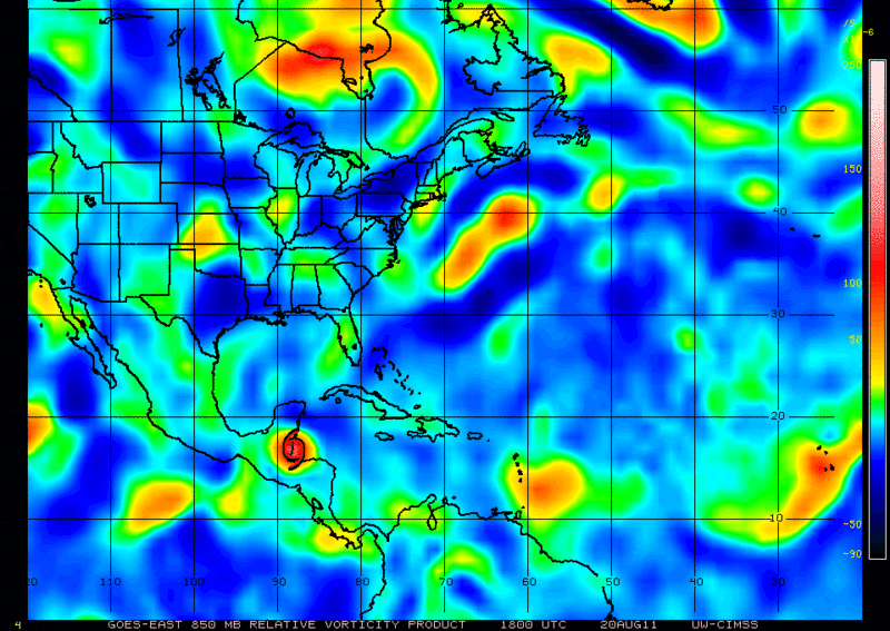
18z850mb Vorticity
0 likes
The following post is NOT an official forecast and should not be used as such. It is just the opinion of the poster and may or may not be backed by sound meteorological data. It is NOT endorsed by any professional institution including storm2k.org For Official Information please refer to the NHC and NWS products.

Not sure Ivanhater, it sometimes can be a very quick process, seen it happen in just 6-9hrs before...
Tomorrow will be a more probable day for formation but even that maybe a touch too soon, 24-36hrs time seems most likely.
Tomorrow will be a more probable day for formation but even that maybe a touch too soon, 24-36hrs time seems most likely.
0 likes
Personal Forecast Disclaimer:
The posts in this forum are NOT official forecast and should not be used as such. They are just the opinion of the poster and may or may not be backed by sound meteorological data. They are NOT endorsed by any professional institution or storm2k.org. For official information, please refer to the NHC and NWS products
The posts in this forum are NOT official forecast and should not be used as such. They are just the opinion of the poster and may or may not be backed by sound meteorological data. They are NOT endorsed by any professional institution or storm2k.org. For official information, please refer to the NHC and NWS products

Re: ATL: INVEST 97L - Discussion
Ivanhater wrote:There really was not much if any wind shift which would mean this is not about to drop a LLC anytime soon...another day or two perhaps.
Maybe the Canadian is on to something
does weaker mean further west?
0 likes
-
brunota2003
- S2K Supporter
- Posts: 9476
- Age: 35
- Joined: Sat Jul 30, 2005 9:56 pm
- Location: Stanton, KY...formerly Havelock, NC
- Contact:
-
Gustywind

- Category 5
- Posts: 12334
- Joined: Mon Sep 03, 2007 7:29 am
- Location: Baie-Mahault, GUADELOUPE
From Wunderground:  http://www.wunderground.com/tropical/at ... track.html
18 GMT 08/20/11 14.5N 56.5W 30 1006 Invest
18 GMT 08/20/11 14.5N 56.5W 30 1006 Invest
0 likes
-
StormClouds63
- Category 2

- Posts: 583
- Age: 62
- Joined: Tue May 13, 2008 11:56 am
- Location: Southwest Louisiana
-
Dave

- Retired Staff

- Posts: 13442
- Age: 75
- Joined: Tue Aug 01, 2006 3:57 pm
- Location: Milan Indiana
- Contact:
706
URNT15 KNHC 201903
AF300 01GGA INVEST HDOB 14 20110820
185330 1444N 05653W 9595 00421 0070 +225 +094 144020 022 029 001 00
185400 1443N 05651W 9593 00424 0071 +220 +092 144017 018 026 001 00
185430 1443N 05650W 9593 00423 0070 +230 +091 142020 021 025 001 00
185500 1442N 05648W 9593 00423 0070 +230 +091 143020 021 022 001 00
185530 1442N 05646W 9596 00421 0070 +230 +092 144020 021 021 001 00
185600 1441N 05644W 9593 00423 0070 +230 +093 146020 020 019 001 00
185630 1441N 05642W 9593 00425 0071 +231 +095 146020 020 019 000 00
185700 1441N 05641W 9592 00424 0071 +227 +095 145017 018 021 000 00
185730 1440N 05639W 9596 00421 0071 +229 +095 151018 019 024 000 00
185800 1440N 05637W 9597 00420 0072 +219 +096 146017 018 030 004 00
185830 1439N 05635W 9594 00423 0071 +229 +093 142021 023 027 001 00
185900 1439N 05634W 9610 00408 0071 +230 +092 142020 022 024 002 00
185930 1438N 05632W 9601 00414 0068 +232 +093 147021 021 022 001 00
190000 1438N 05631W 9593 00421 0067 +229 +092 143020 021 023 000 00
190030 1438N 05629W 9604 00411 0069 +213 +093 129025 027 028 005 00
190100 1437N 05628W 9586 00426 0071 +204 +090 132025 025 032 005 00
190130 1437N 05626W 9582 00429 0067 +224 +085 134025 026 031 000 00
190200 1436N 05625W 9585 00431 0069 +230 +081 136025 026 029 001 00
190230 1436N 05623W 9596 00422 0071 +230 +083 136024 025 027 003 03
190300 1436N 05621W 9594 00424 0072 +230 +087 136023 024 029 001 00
$$
;
0 likes
-
Aric Dunn
- Category 5
- Posts: 21238
- Age: 43
- Joined: Sun Sep 19, 2004 9:58 pm
- Location: Ready for the Chase.
- Contact:
Re: ATL: INVEST 97L - Discussion
cycloneye wrote:18z Best Track
Aric,you see something at those coordinates?
AL, 97, 2011082018, , BEST, 0, 145N, 565W, 30, 1006, DB
ftp://ftp.tpc.ncep.noaa.gov/atcf/tcweb/ ... 011.invest
funny.. was just about to say.. good wind shift 14.5N 57W according recon
0 likes
Note: If I make a post that is brief. Please refer back to previous posts for the analysis or reasoning. I do not re-write/qoute what my initial post said each time.
If there is nothing before... then just ask
Space & Atmospheric Physicist, Embry-Riddle Aeronautical University,
I believe the sky is falling...
If there is nothing before... then just ask
Space & Atmospheric Physicist, Embry-Riddle Aeronautical University,
I believe the sky is falling...
-
plasticup


-
Aric Dunn
- Category 5
- Posts: 21238
- Age: 43
- Joined: Sun Sep 19, 2004 9:58 pm
- Location: Ready for the Chase.
- Contact:
well not well defined but thats where it seems its forming..
0 likes
Note: If I make a post that is brief. Please refer back to previous posts for the analysis or reasoning. I do not re-write/qoute what my initial post said each time.
If there is nothing before... then just ask
Space & Atmospheric Physicist, Embry-Riddle Aeronautical University,
I believe the sky is falling...
If there is nothing before... then just ask
Space & Atmospheric Physicist, Embry-Riddle Aeronautical University,
I believe the sky is falling...
-
Dave
- Retired Staff
- Posts: 13442
- Age: 75
- Joined: Tue Aug 01, 2006 3:57 pm
- Location: Milan Indiana
- Contact:
039
URNT15 KNHC 201913
AF300 01GGA INVEST HDOB 15 20110820
190330 1435N 05620W 9594 00424 0072 +230 +090 134023 024 029 000 00
190400 1435N 05618W 9595 00424 0072 +230 +091 133024 025 028 001 00
190430 1434N 05616W 9594 00424 0072 +230 +092 131024 024 029 000 00
190500 1434N 05615W 9598 00419 0071 +229 +092 136023 024 029 001 00
190530 1433N 05613W 9591 00426 0071 +230 +094 136022 023 029 000 00
190600 1433N 05611W 9591 00425 0071 +231 +094 138022 023 029 001 03
190630 1433N 05609W 9592 00426 0072 +230 +095 138024 024 028 000 03
190700 1433N 05607W 9597 00423 0072 +233 +095 135023 024 029 000 00
190730 1433N 05606W 9587 00432 0073 +233 +096 134024 025 031 001 00
190800 1433N 05606W 9587 00432 0073 +233 +096 136025 026 031 002 00
190830 1432N 05602W 9594 00426 0074 +231 +096 137026 026 033 002 00
190900 1432N 05600W 9586 00433 0075 +227 +095 141024 024 033 005 03
190930 1431N 05559W 9592 00427 0076 +214 +094 135023 024 035 007 00
191000 1430N 05558W 9589 00429 0074 +230 +092 135024 024 030 001 00
191030 1429N 05556W 9597 00424 0074 +230 +092 135023 024 026 000 00
191100 1427N 05555W 9592 00429 0074 +230 +092 136022 023 026 001 00
191130 1426N 05554W 9597 00423 0074 +230 +093 138023 023 025 001 00
191200 1425N 05553W 9595 00424 0073 +230 +095 139023 024 024 001 00
191230 1424N 05551W 9589 00429 0072 +230 +095 137023 024 025 001 00
191300 1422N 05550W 9601 00418 0072 +231 +097 139023 024 025 002 00
$$
;
0 likes
-
cycloneye

- Admin

- Posts: 149433
- Age: 69
- Joined: Thu Oct 10, 2002 10:54 am
- Location: San Juan, Puerto Rico
Re:
Aric Dunn wrote:well not well defined but thats where it seems its forming..
There is the wind shift.

0 likes
Visit the Caribbean-Central America Weather Thread where you can find at first post web cams,radars
and observations from Caribbean basin members Click Here
and observations from Caribbean basin members Click Here

Re:
KWT wrote:Not sure Ivanhater, it sometimes can be a very quick process, seen it happen in just 6-9hrs before...
Tomorrow will be a more probable day for formation but even that maybe a touch too soon, 24-36hrs time seems most likely.
Had to step away for a minute and simply take a deep breath from all the "minute by minute" obs - LOL
Simply looking at current broad Atlantic Sat. loop, and then taking into account the overall structure and progress 97L has made during the past 24 hours, and finally simply taking into account the overall dynamic conditions in place, and I can't help but think that perhaps after a good 3-4 hour "depression watch", that i'll come on back and "lo and hehold", a huge convective bomb will have gone off around 16N and 57W! Am probably wrong, but just have that feeling that it's about to pop. That, and about 4-6 hours and I would'nt think a depression at that time would be out of the question. 'Course, then we'ed need recon or a perfectly place bouy or cruise ship to provide the feet on the ground, er...in the water data to confirm.
0 likes
Andy D
(For official information, please refer to the NHC and NWS products.)
(For official information, please refer to the NHC and NWS products.)
Probably forming just south of 14.5N, maybe around 14.3 or 14.4N.
Not well defined but that wind shift is quite tight to be fair. Recon enedws to go south of there to see whats going on and if there is any more change in wind direction.
Not well defined but that wind shift is quite tight to be fair. Recon enedws to go south of there to see whats going on and if there is any more change in wind direction.
0 likes
Personal Forecast Disclaimer:
The posts in this forum are NOT official forecast and should not be used as such. They are just the opinion of the poster and may or may not be backed by sound meteorological data. They are NOT endorsed by any professional institution or storm2k.org. For official information, please refer to the NHC and NWS products
The posts in this forum are NOT official forecast and should not be used as such. They are just the opinion of the poster and may or may not be backed by sound meteorological data. They are NOT endorsed by any professional institution or storm2k.org. For official information, please refer to the NHC and NWS products

Who is online
Users browsing this forum: No registered users and 42 guests