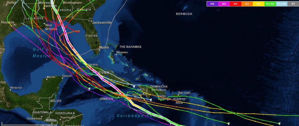
ATL: IRENE - Models

Moderator: S2k Moderators

Message
Author
User avatar
Ivanhater
Storm2k Moderator
Storm2k Moderator
Posts: 11161
Age: 38
Joined: Fri Jul 01, 2005 8:25 am
Location: Pensacola

Re: Re:

#801 Postby Ivanhater » Fri Aug 19, 2011 11:40 am

fox13weather wrote:
Ivanhater wrote:
Aric Dunn wrote:165 hours enters SE gulf heading NNW


Not going to be a Charley track..trough has lifted out


Honestly. who knows?? 165 hours out?? We don't even have a named storm on the map and we are talking absolutes? What is the margin of error at 165 hours??? 500 miles???


We know that, we are just talking about this particular model run.
0 likes   
Michael

Aric Dunn
Category 5
Category 5
Posts: 21238
Age: 42
Joined: Sun Sep 19, 2004 9:58 pm
Location: Ready for the Chase.
Contact:

Re: Re:

#802 Postby Aric Dunn » Fri Aug 19, 2011 11:41 am

fox13weather wrote:
Ivanhater wrote:
Aric Dunn wrote:165 hours enters SE gulf heading NNW


Not going to be a Charley track..trough has lifted out


Honestly. who knows?? 165 hours out?? We don't even have a named storm on the map and we are talking absolutes? What is the margin of error at 165 hours??? 500 miles???


yeah we know... and not being absolute at all. :) just watching
0 likes   
Note: If I make a post that is brief. Please refer back to previous posts for the analysis or reasoning. I do not re-write/qoute what my initial post said each time.
If there is nothing before... then just ask :)

Space & Atmospheric Physicist, Embry-Riddle Aeronautical University,
I believe the sky is falling...

User avatar
Blown Away
S2K Supporter
S2K Supporter
Posts: 10147
Joined: Wed May 26, 2004 6:17 am

Re: ATL: INVEST 97L-Models

#803 Postby Blown Away » Fri Aug 19, 2011 11:42 am

Pensacola, another E shift.
0 likes   
Hurricane Eye Experience: David 79, Irene 99, Frances 04, Jeanne 04, Wilma 05... EYE COMING MY WAY IN 2024…
Hurricane Brush Experience: Andrew 92, Erin 95, Floyd 99, Matthew 16, Irma 17, Ian 22, Nicole 22…

User avatar
Ivanhater
Storm2k Moderator
Storm2k Moderator
Posts: 11161
Age: 38
Joined: Fri Jul 01, 2005 8:25 am
Location: Pensacola

Re: ATL: INVEST 97L-Models

#804 Postby Ivanhater » Fri Aug 19, 2011 11:42 am

Who has the updated GFS list :D
0 likes   
Michael

ddad040
Tropical Low
Tropical Low
Posts: 15
Joined: Wed Oct 05, 2005 5:38 am
Location: Tampa, Fl
Contact:

Re: ATL: INVEST 97L-Models

#805 Postby ddad040 » Fri Aug 19, 2011 11:42 am

Ivanhater wrote:Loos more like Dennis 2005 track so far

Elena 1985?
0 likes   

User avatar
Ivanhater
Storm2k Moderator
Storm2k Moderator
Posts: 11161
Age: 38
Joined: Fri Jul 01, 2005 8:25 am
Location: Pensacola

Re: ATL: INVEST 97L-Models

#806 Postby Ivanhater » Fri Aug 19, 2011 11:42 am

Blown Away wrote:Pensacola, another E shift.


West shift..it hit the big bend last run
0 likes   
Michael

User avatar
PTrackerLA
Category 5
Category 5
Posts: 5277
Age: 41
Joined: Thu Oct 10, 2002 8:40 pm
Location: Lafayette, LA

Re: ATL: INVEST 97L-Models

#807 Postby PTrackerLA » Fri Aug 19, 2011 11:42 am

ACtually that's a west shift from 06z.
0 likes   

User avatar
Miami Storm Tracker
Category 4
Category 4
Posts: 910
Age: 67
Joined: Sun Jun 13, 2010 10:12 pm
Location: Key Largo, Fla.
Contact:

Re: ATL: INVEST 97L-Models

#808 Postby Miami Storm Tracker » Fri Aug 19, 2011 11:42 am

cycloneye wrote:
SFLcane wrote:Donna like maybe wxman57?


For those members that dont remember the Donna track,here it is.

Image


I mentioned that last night, Cycloneye you trying to make me feel old I was in key west when she hit.
0 likes   

User avatar
Ivanhater
Storm2k Moderator
Storm2k Moderator
Posts: 11161
Age: 38
Joined: Fri Jul 01, 2005 8:25 am
Location: Pensacola

Re: ATL: INVEST 97L-Models

#809 Postby Ivanhater » Fri Aug 19, 2011 11:45 am

Updated GFS!


06Z Mon: up U.S. East coast
12Z Mon: central LA 8/30
18Z Mon: skirts FL east coast to Charleston 8/27-8
00Z Tue: Tampa 8/27
06Z Tue: Pensacola 8/28
12Z Tue: S tip FL 8/26 to MS 8/28
18Z Tue: skirts FL east coast to Beaufort, SC 8/27-8
00Z Wed: FL Keys 8/26 to Apalachicola 8/27
06Z Wed: Ft. Lauderdale 8/26
12Z Wed: Georgia/South Carolina border 8/27
18Z Wed: West Palm beach up east coast of FL 8/25
00Z Thur: FL Keys 8/26 to west coast of FL 8/27
06Z Thur: Key West 8/26 to Big bend 8/27
12z Thur: Key West 8/26 to Tampa/Big bend 8/27
18z Thur: Houston 8/30
00Z Fri: Mobile 8/29
06Z Fri: Big bend 8/28
12Z Fri: Pensacola 8/29
0 likes   
Michael

weatherguy2
Tropical Depression
Tropical Depression
Posts: 72
Joined: Sun Aug 01, 2010 2:45 am

Re: ATL: INVEST 97L-Models

#810 Postby weatherguy2 » Fri Aug 19, 2011 11:45 am

weatherguy2 wrote:Using the best consensus, I think we might end up having a path similar to one of these:
Frederic 1979
Camille 1969
Lili 2002
Elena 1985
Ivan 2004
Gustav 2008 (2008 a good analog year for 2011)
Dennis 2005 (2005 a good analog year for 2011)
1915 Galveston hurricane
1909 central LA hurricane
1851 FL panhandle hurricane
1917 FL panhandle hurricane


Dennis was on my list. :)

Image
Last edited by weatherguy2 on Fri Aug 19, 2011 11:49 am, edited 1 time in total.
0 likes   

User avatar
sittingduck
S2K Supporter
S2K Supporter
Posts: 111
Joined: Mon Aug 13, 2007 3:16 pm
Location: venice florida

Re: ATL: INVEST 97L-Models

#811 Postby sittingduck » Fri Aug 19, 2011 11:47 am

Thanks all of you that posted and remarked on this run. I have been coming and reading here for years and I think that was the most entertaining and educational reading yet lol.
0 likes   

User avatar
Ivanhater
Storm2k Moderator
Storm2k Moderator
Posts: 11161
Age: 38
Joined: Fri Jul 01, 2005 8:25 am
Location: Pensacola

Re: ATL: INVEST 97L-Models

#812 Postby Ivanhater » Fri Aug 19, 2011 11:49 am

sittingduck wrote:Thanks all of you that posted and remarked on this run. I have been coming and reading here for years and I think that was the most entertaining and educational reading yet lol.


The uncertainty is quite large with this one. I do believe this won't run up the east coast of Florida though so my bet is Gulf coast or Florida Peninsula at this time.
0 likes   
Michael

Aric Dunn
Category 5
Category 5
Posts: 21238
Age: 42
Joined: Sun Sep 19, 2004 9:58 pm
Location: Ready for the Chase.
Contact:

#813 Postby Aric Dunn » Fri Aug 19, 2011 12:00 pm

well if anyone is interested... 12z FNMOC

https://www.fnmoc.navy.mil/wxmap_cgi/cg ... t=Tropical
0 likes   
Note: If I make a post that is brief. Please refer back to previous posts for the analysis or reasoning. I do not re-write/qoute what my initial post said each time.
If there is nothing before... then just ask :)

Space & Atmospheric Physicist, Embry-Riddle Aeronautical University,
I believe the sky is falling...

weatherguy2
Tropical Depression
Tropical Depression
Posts: 72
Joined: Sun Aug 01, 2010 2:45 am

Re: ATL: INVEST 97L-Models

#814 Postby weatherguy2 » Fri Aug 19, 2011 12:01 pm

On 12z GFS it was a 970 mb cane at landfall:
Image
0 likes   

User avatar
Ivanhater
Storm2k Moderator
Storm2k Moderator
Posts: 11161
Age: 38
Joined: Fri Jul 01, 2005 8:25 am
Location: Pensacola

Re:

#815 Postby Ivanhater » Fri Aug 19, 2011 12:02 pm

Aric Dunn wrote:well if anyone is interested... 12z FNMOC

https://www.fnmoc.navy.mil/wxmap_cgi/cg ... t=Tropical


It's the Nogaps but similar to the 12z Nogaps
0 likes   
Michael

User avatar
Blown Away
S2K Supporter
S2K Supporter
Posts: 10147
Joined: Wed May 26, 2004 6:17 am

Re: ATL: INVEST 97L-Models

#816 Postby Blown Away » Fri Aug 19, 2011 12:04 pm

So latest GFS a little W to Pensacola and EURO was SFL and up EC, right??
0 likes   
Hurricane Eye Experience: David 79, Irene 99, Frances 04, Jeanne 04, Wilma 05... EYE COMING MY WAY IN 2024…
Hurricane Brush Experience: Andrew 92, Erin 95, Floyd 99, Matthew 16, Irma 17, Ian 22, Nicole 22…

Aric Dunn
Category 5
Category 5
Posts: 21238
Age: 42
Joined: Sun Sep 19, 2004 9:58 pm
Location: Ready for the Chase.
Contact:

Re: Re:

#817 Postby Aric Dunn » Fri Aug 19, 2011 12:05 pm

Ivanhater wrote:
Aric Dunn wrote:well if anyone is interested... 12z FNMOC

https://www.fnmoc.navy.mil/wxmap_cgi/cg ... t=Tropical


It's the Nogaps but similar to the 12z Nogaps


its the 12z nogaps.. https://www.fnmoc.navy.mil/wxmap_cgi/cg ... t=Tropical
Last edited by Aric Dunn on Fri Aug 19, 2011 12:05 pm, edited 1 time in total.
0 likes   
Note: If I make a post that is brief. Please refer back to previous posts for the analysis or reasoning. I do not re-write/qoute what my initial post said each time.
If there is nothing before... then just ask :)

Space & Atmospheric Physicist, Embry-Riddle Aeronautical University,
I believe the sky is falling...

User avatar
Macrocane
Category 5
Category 5
Posts: 4218
Age: 36
Joined: Sun May 24, 2009 5:35 pm
Location: El Salvador

Re: ATL: INVEST 97L-Models

#818 Postby Macrocane » Fri Aug 19, 2011 12:05 pm

I'm getting kind of tired of the "we don't even have a center yet" comments, we know that but as other memebers have said we're just watching run after run and talking about it, that's the point of this thread, isn't it? :wink:
0 likes   

User avatar
Ivanhater
Storm2k Moderator
Storm2k Moderator
Posts: 11161
Age: 38
Joined: Fri Jul 01, 2005 8:25 am
Location: Pensacola

Re: ATL: INVEST 97L-Models

#819 Postby Ivanhater » Fri Aug 19, 2011 12:05 pm

12z Canadian is very far south...South of Jamaica

Image
0 likes   
Michael

User avatar
Ivanhater
Storm2k Moderator
Storm2k Moderator
Posts: 11161
Age: 38
Joined: Fri Jul 01, 2005 8:25 am
Location: Pensacola

Re: Re:

#820 Postby Ivanhater » Fri Aug 19, 2011 12:06 pm

Aric Dunn wrote:
Ivanhater wrote:
Aric Dunn wrote:well if anyone is interested... 12z FNMOC

https://www.fnmoc.navy.mil/wxmap_cgi/cg ... t=Tropical


It's the Nogaps but similar to the 12z Nogaps


its the 12z nogaps.. https://www.fnmoc.navy.mil/wxmap_cgi/cg ... t=Tropical


I meant GFS :lol:
0 likes   
Michael


Return to “2011”

Who is online

Users browsing this forum: No registered users and 6 guests