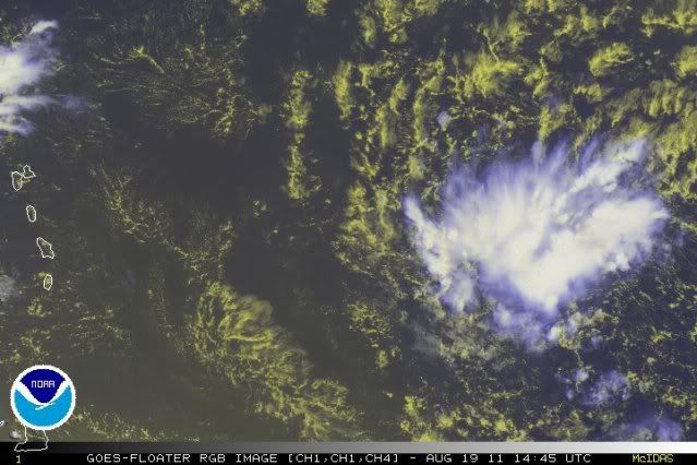
Nothing to 97L (photo below) but a peanut cluster of thunderstorms and a large SAL swirl - and 98L is going fishing, so...
http://www.ssd.noaa.gov/goes/east/tatl/vis-l.jpg
Have a good weekend, everyone!
Frank
ATL: IRENE - Remnants - Discussion
Moderator: S2k Moderators
Re: ATL: INVEST 97L - Discussion
0 likes
-
ConvergenceZone
.gif)
- Category 5

- Posts: 5241
- Joined: Fri Jul 29, 2005 1:40 am
- Location: Northern California
Re: ATL: INVEST 97L - Discussion
Frank2 wrote:Nothing to 97L (photo below) but a peanut cluster of thunderstorms and a large SAL swirl - and 98L is going fishing, so...
http://www.ssd.noaa.gov/goes/east/tatl/vis-l.jpg
Have a good weekend, everyone!
Frank
Yep, it's doing exactly what it suppose to right now...Wait until later this weekend, and it will be a
different ballgame...
0 likes
-
Aric Dunn
- Category 5
- Posts: 21238
- Age: 43
- Joined: Sun Sep 19, 2004 9:58 pm
- Location: Ready for the Chase.
- Contact:
If convection can hold like this or increase today and not die... tomorrow will be the day for development.
0 likes
Note: If I make a post that is brief. Please refer back to previous posts for the analysis or reasoning. I do not re-write/qoute what my initial post said each time.
If there is nothing before... then just ask
Space & Atmospheric Physicist, Embry-Riddle Aeronautical University,
I believe the sky is falling...
If there is nothing before... then just ask
Space & Atmospheric Physicist, Embry-Riddle Aeronautical University,
I believe the sky is falling...
-
northjaxpro

- S2K Supporter

- Posts: 8900
- Joined: Mon Sep 27, 2010 11:21 am
- Location: Jacksonville, FL
Aric, if, and it is a BIG IF, 97L's convection sustains as you mentioned, then it may be a sign it is beginning to get its act together. I personally did not expect this to happen until at least Sunday at the earliest. If 97L begins to organize at this stage, then I think the system's chances of missing the Caribbean islands to the north would increase. A stronger, organized system I think will have 97L gain a bit latitude in time. Plus, unfortunately, if 97L is organizing quicker, then the probabilities of a impact all along the SE U.S. Coast will also increase significantly.
Again, this is not an official forecast, just an opinion and observations from a Storm2K member.
Still a long time to watch this unfold folks. We all just need to stay vigilant that's for sure!
Again, this is not an official forecast, just an opinion and observations from a Storm2K member.
Still a long time to watch this unfold folks. We all just need to stay vigilant that's for sure!
0 likes
NEVER, EVER SAY NEVER in the tropics and weather in general, and most importantly, with life itself!!
________________________________________________________________________________________
Fay 2008 Beryl 2012 Debby 2012 Colin 2016 Hermine 2016 Julia 2016 Matthew 2016 Irma 2017 Dorian 2019
________________________________________________________________________________________
Fay 2008 Beryl 2012 Debby 2012 Colin 2016 Hermine 2016 Julia 2016 Matthew 2016 Irma 2017 Dorian 2019
-
Aric Dunn
- Category 5
- Posts: 21238
- Age: 43
- Joined: Sun Sep 19, 2004 9:58 pm
- Location: Ready for the Chase.
- Contact:
Re:
northjaxpro wrote:Aric, if, and it is a BIG IF, 97L's convection sustains as you mentioned, then it may be a sign it is beginning to get its act together. I personally did not expect this to happen until at least Sunday at the earliest. If 97L begins to organize at this stage, then I think the system's chances of missing the Caribbean islands to the north would increase. A stronger, organized system I think will have 97L gain a bit latitude in time. Plus, unfortunately, if 97L is organizing quicker, then the probabilities of a impact all along the SE U.S. Coast will also increase significantly.
Again, this is not an official forecast, just an opinion and observations from a Storm2K member.
Still a long time to watch this unfold folks. We all just need to stay vigilant that's for sure!
yeah, the convection pattern is still a little to pop corn like but now able to maintain at least some organization to where its developing..
0 likes
Note: If I make a post that is brief. Please refer back to previous posts for the analysis or reasoning. I do not re-write/qoute what my initial post said each time.
If there is nothing before... then just ask
Space & Atmospheric Physicist, Embry-Riddle Aeronautical University,
I believe the sky is falling...
If there is nothing before... then just ask
Space & Atmospheric Physicist, Embry-Riddle Aeronautical University,
I believe the sky is falling...
-
Gustywind

- Category 5
- Posts: 12334
- Joined: Mon Sep 03, 2007 7:29 am
- Location: Baie-Mahault, GUADELOUPE
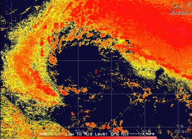
Given the latest form NRL: 1415 UTC
 http://www.nrlmry.navy.mil/tc-bin/tc_ho ... m&PROD=vis
Has lot another one 1mb, down to 1006 mb and located more west...
20110819.1415.97LINVEST.25kts-1006mb-135N-473W
20110819.1015.97LINVEST.25kts-1007mb-135N-442W.
Has lot another one 1mb, down to 1006 mb and located more west...
20110819.1415.97LINVEST.25kts-1006mb-135N-473W
20110819.1015.97LINVEST.25kts-1007mb-135N-442W.
0 likes
-
Aric Dunn
- Category 5
- Posts: 21238
- Age: 43
- Joined: Sun Sep 19, 2004 9:58 pm
- Location: Ready for the Chase.
- Contact:
Re: ATL: INVEST 97L - Discussion
It past nearly right over this buoy last night... pretty low pressure already..
next buoy it should go over in the next 6 hours. if it updates http://www.ndbc.noaa.gov/station_page.php?station=41nt0
then late tonight ...http://www.ndbc.noaa.gov/station_page.php?station=41040
next buoy it should go over in the next 6 hours. if it updates http://www.ndbc.noaa.gov/station_page.php?station=41nt0
then late tonight ...http://www.ndbc.noaa.gov/station_page.php?station=41040
0 likes
Note: If I make a post that is brief. Please refer back to previous posts for the analysis or reasoning. I do not re-write/qoute what my initial post said each time.
If there is nothing before... then just ask
Space & Atmospheric Physicist, Embry-Riddle Aeronautical University,
I believe the sky is falling...
If there is nothing before... then just ask
Space & Atmospheric Physicist, Embry-Riddle Aeronautical University,
I believe the sky is falling...
-
ozonepete
- Professional-Met

- Posts: 4743
- Joined: Mon Sep 07, 2009 3:23 pm
- Location: From Ozone Park, NYC / Now in Brooklyn, NY
Re: ATL: INVEST 97L - Discussion
Whoa... This has done a sudden convective spike and has outflow cirrus developing. The change in just the last hour or two is pretty impressive.
0 likes

Gotta admit it does look abit more solid then it did yesterday. Seems like its trying to wrap itself up to me...
0 likes
Personal Forecast Disclaimer:
The posts in this forum are NOT official forecast and should not be used as such. They are just the opinion of the poster and may or may not be backed by sound meteorological data. They are NOT endorsed by any professional institution or storm2k.org. For official information, please refer to the NHC and NWS products
The posts in this forum are NOT official forecast and should not be used as such. They are just the opinion of the poster and may or may not be backed by sound meteorological data. They are NOT endorsed by any professional institution or storm2k.org. For official information, please refer to the NHC and NWS products
-
gatorcane

- S2K Supporter
- Posts: 23708
- Age: 48
- Joined: Sun Mar 13, 2005 3:54 pm
- Location: Boca Raton, FL
Re:
KWT wrote:Gotta admit it does look abit more solid then it did yesterday. Seems like its trying to wrap itself up to me...
Yep, should be 50% the next TWO....compared to 24 hours ago, its much better organized. Question is will it continue to move 280, gain even more lattitude as is deepends, or will it feel the ridge more and dive some WSW as some of the models prog.
Looks like it is really trying to get its act together now, as expected once it got to 55W....
0 likes

-
Ivanhater

- Storm2k Moderator

- Posts: 11221
- Age: 39
- Joined: Fri Jul 01, 2005 8:25 am
- Location: Pensacola
Re: ATL: INVEST 97L - Discussion
Curren GFS, Euro and Cmc are not that excited about this system until after it is in the Caribbean.
0 likes
Michael

Re: ATL: INVEST 97L - Discussion
Well it passed 50W without any major convective burst and its still pretty dry all the way to the islands so I guess the models shift west closer to Jamaica then?
0 likes
Re: ATL: INVEST 97L - Discussion
Good entrainment of the atmosphere now. Probably bears watching.
0 likes
-
ozonepete
- Professional-Met
- Posts: 4743
- Joined: Mon Sep 07, 2009 3:23 pm
- Location: From Ozone Park, NYC / Now in Brooklyn, NY
Re: ATL: INVEST 97L - Discussion
Nimbus wrote:Well it passed 50W without any major convective burst and its still pretty dry all the way to the islands so I guess the models shift west closer to Jamaica then?
IMHO, it's having a pretty big convective burst right now...
0 likes
-
cycloneye

- Admin

- Posts: 149426
- Age: 69
- Joined: Thu Oct 10, 2002 10:54 am
- Location: San Juan, Puerto Rico
Re: ATL: INVEST 97L - Discussion
Nimbus wrote:Well it passed 50W without any major convective burst and its still pretty dry all the way to the islands so I guess the models shift west closer to Jamaica then?
Is not as dry as before. And convection has increased in the past few hours.

0 likes
Visit the Caribbean-Central America Weather Thread where you can find at first post web cams,radars
and observations from Caribbean basin members Click Here
and observations from Caribbean basin members Click Here
-
ozonepete
- Professional-Met
- Posts: 4743
- Joined: Mon Sep 07, 2009 3:23 pm
- Location: From Ozone Park, NYC / Now in Brooklyn, NY
Re: ATL: INVEST 97L - Discussion
0 likes
-
cycloneye
- Admin
- Posts: 149426
- Age: 69
- Joined: Thu Oct 10, 2002 10:54 am
- Location: San Juan, Puerto Rico
ATL: IRENE - Recon
Starting on Saturday afternoon the first mission.
Code: Select all
000
NOUS42 KNHC 191555
WEATHER RECONNAISSANCE FLIGHTS
CARCAH, NATIONAL HURRICANE CENTER, MIAMI, FL.
1155 AM EDT FRI 19 AUGUST 2011
SUBJECT: TROPICAL CYCLONE PLAN OF THE DAY (TCPOD)
         VALID 20/1100Z TO 21/1100Z AUGUST 2011
         TCPOD NUMBER.....11-080

I.  ATLANTIC REQUIREMENTS
    1. SUSPECT AREA (APPROACHING LESSER ANTILLES)
       FLIGHT ONE -- TEAL 71
       A. 20/1800Z
       B. AFXXX 01GGA INVEST
       C. 20/1615Z
       D. 15.3N 57.5W
       E. 20/1730Z TO 20/2130Z
       F. SFC TO 10,000 FT

        OUTLOOK FOR SUCCEEDING DAY:
       A. BEGIN 6-HRLY FIXES ON WHAT IS NOW THE SUSPECT
          AREA IF IT DEVELOPS AT 21/1200Z.
       B. POSSIBLE G-IV SURVEILANCE MISSION FOR THE
          SAME SYSTEM AT 22/0000Z.
0 likes
Visit the Caribbean-Central America Weather Thread where you can find at first post web cams,radars
and observations from Caribbean basin members Click Here
and observations from Caribbean basin members Click Here
-
ozonepete
- Professional-Met
- Posts: 4743
- Joined: Mon Sep 07, 2009 3:23 pm
- Location: From Ozone Park, NYC / Now in Brooklyn, NY
Re: ATL: INVEST 97L - Discussion
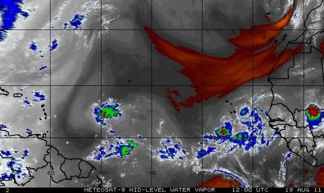
Here's another CIMSS chart of mid-level moisture. Looks pretty decent now - moistening up nicely.
0 likes
Yeah ,as long as mid-upper shear remains low that dry air isn't going to be too much of a problem, now if it does increase then we could have more of an issue.
0 likes
Personal Forecast Disclaimer:
The posts in this forum are NOT official forecast and should not be used as such. They are just the opinion of the poster and may or may not be backed by sound meteorological data. They are NOT endorsed by any professional institution or storm2k.org. For official information, please refer to the NHC and NWS products
The posts in this forum are NOT official forecast and should not be used as such. They are just the opinion of the poster and may or may not be backed by sound meteorological data. They are NOT endorsed by any professional institution or storm2k.org. For official information, please refer to the NHC and NWS products
Who is online
Users browsing this forum: No registered users and 15 guests