ATL : HARVEY - Tropical Depression - Discussion
Moderator: S2k Moderators
-
Blown Away

- S2K Supporter

- Posts: 10253
- Joined: Wed May 26, 2004 6:17 am
Re: ATL : EIGHT - Tropical Depression - Discussion
Kinda getting the bowling ball roll to it, even though most of the convection is N of the center.
0 likes
Hurricane Eye Experience: David 79, Irene 99, Frances 04, Jeanne 04, Wilma 05… Hurricane Brush Experience: Andrew 92, Erin 95, Floyd 99, Matthew 16, Irma 17, Ian 22, Nicole 22…

Re: ATL : EIGHT - Tropical Depression - Discussion
It looks somewhat better than last night, for sure...I would say it could go either way, but if this indeed stays north of 16, I would say this should be Harvey at some point soon.
0 likes
Re: ATL: EIGHT - Recon
Looks like they are headed back to base.
URNT15 KNHC 191428
AF302 0308A CYCLONE HDOB 40 20110819
141830 1603N 08219W 8431 01566 0098 +164 +144 143026 026 024 000 00
141900 1603N 08217W 8389 01602 0090 +166 +137 142026 026 023 000 03
141930 1603N 08216W 8031 01974 0087 +146 +126 151023 025 /// /// 03
142000 1603N 08214W 7748 02291 0093 +129 +111 162022 022 /// /// 03
142030 1603N 08212W 7430 02646 0102 +108 +092 168023 024 /// /// 03
142100 1603N 08211W 7133 02989 0095 +096 +074 169022 023 /// /// 03
142130 1603N 08209W 6855 03322 0093 +082 +051 174022 023 /// /// 03
142200 1602N 08207W 6617 03615 0088 +066 +051 180022 024 026 000 03
142230 1601N 08206W 6385 03908 0083 +051 +033 180022 023 026 000 03
142300 1600N 08204W 6163 04197 0083 +036 +001 178023 024 026 000 03
142330 1559N 08203W 5962 04461 0073 +022 -007 172023 023 025 000 03
142400 1558N 08202W 5776 04718 0072 +007 -017 167022 023 025 000 00
142430 1557N 08200W 5613 04949 0071 -005 -033 159021 021 023 000 03
142500 1556N 08158W 5455 05175 0251 -019 -044 159021 022 023 000 03
142530 1555N 08157W 5307 05396 0265 -032 -060 152019 021 021 000 00
142600 1554N 08155W 5172 05600 0277 -043 -075 151018 018 022 000 03
142630 1553N 08154W 5040 05803 0289 -054 -096 155017 017 020 000 00
142700 1552N 08152W 4909 06017 0306 -064 -117 143017 018 019 000 00
142730 1551N 08151W 4789 06208 0319 -075 -135 139018 018 019 000 03
142800 1550N 08149W 4695 06362 0329 -082 -137 138014 015 018 000 03
0 likes
Re: ATL: EIGHT - Recon
For the record, the last vortex message of this mission. Next mission is scheduled to launch at 4:30 PM EDT
URNT12 KNHC 191417
VORTEX DATA MESSAGE AL082011
A. 19/13:57:30Z
B. 16 deg 04 min N
083 deg 27 min W
C. 850 mb 1459 m
D. 35 kt
E. 356 deg 17 nm
F. 103 deg 40 kt
G. 354 deg 42 nm
H. 1005 mb
I. 15 C / 1538 m
J. 20 C / 1526 m
K. 16 C / NA
L. NA
M. NA
N. 12345 / 8
O. 0.02 / 1 nm
P. AF302 0308A CYCLONE OB 17
MAX FL WIND 40 KT N QUAD 13:44:20Z
0 likes
Re: ATL : EIGHT - Tropical Depression - Discussion
Latest vortex suggests 35kt, which would qualify for a TS...let's see how they go...
0 likes
-
wxman57

- Moderator-Pro Met

- Posts: 23174
- Age: 68
- Joined: Sat Jun 21, 2003 8:06 pm
- Location: Houston, TX (southwest)
Re: ATL : EIGHT - Tropical Depression - Discussion
That latest vortex message reported only 38 kts as the max FL wind in the NE quadrant. That's a bit low. I still don't trust those SFMR winds as far as I can throw them, so to speak. They're consistently well above the FL winds. It does appear borderline for upgrade now. They could go either way. If not Harvey now, it should be Harvey this afternoon.
PS: No upgrade - still TD 8
PS: No upgrade - still TD 8
0 likes

Yeah its close Wxman57 but the NHC probably would want a 40-42kts at flight level for an upgrade so they may just hold off for now.
0 likes
Personal Forecast Disclaimer:
The posts in this forum are NOT official forecast and should not be used as such. They are just the opinion of the poster and may or may not be backed by sound meteorological data. They are NOT endorsed by any professional institution or storm2k.org. For official information, please refer to the NHC and NWS products
The posts in this forum are NOT official forecast and should not be used as such. They are just the opinion of the poster and may or may not be backed by sound meteorological data. They are NOT endorsed by any professional institution or storm2k.org. For official information, please refer to the NHC and NWS products
-
wxman57
- Moderator-Pro Met
- Posts: 23174
- Age: 68
- Joined: Sat Jun 21, 2003 8:06 pm
- Location: Houston, TX (southwest)
Re: ATL : EIGHT - Tropical Depression - Discussion
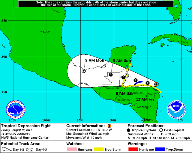
TROPICAL DEPRESSION EIGHT ADVISORY NUMBER 3
NWS NATIONAL HURRICANE CENTER MIAMI FL AL082011
1100 AM EDT FRI AUG 19 2011
...HURRICANE HUNTER AIRCRAFT FINDS DEPRESSION JUST BELOW
TROPICAL-STORM STRENGTH...TROPICAL STORM WARNING ISSUED...
SUMMARY OF 1100 AM EDT...1500 UTC...INFORMATION
-----------------------------------------------
LOCATION...16.1N 83.7W
ABOUT 195 MI...310 KM E OF ISLA ROATAN HONDURAS
ABOUT 315 MI...505 KM ESE OF BELIZE CITY
MAXIMUM SUSTAINED WINDS...35 MPH...55 KM/H
PRESENT MOVEMENT...W OR 275 DEGREES AT 10 MPH...17 KM/H
MINIMUM CENTRAL PRESSURE...1005 MB...29.68 INCHES
0 likes
-
ozonepete
- Professional-Met

- Posts: 4743
- Joined: Mon Sep 07, 2009 3:23 pm
- Location: From Ozone Park, NYC / Now in Brooklyn, NY
Re: ATL : EIGHT - Tropical Depression - Discussion
Yeah, looks like 5PM for Harvey.
Proximity to land not bothering this very much. Notice the outflow cirrus starting to show on northwestern side.
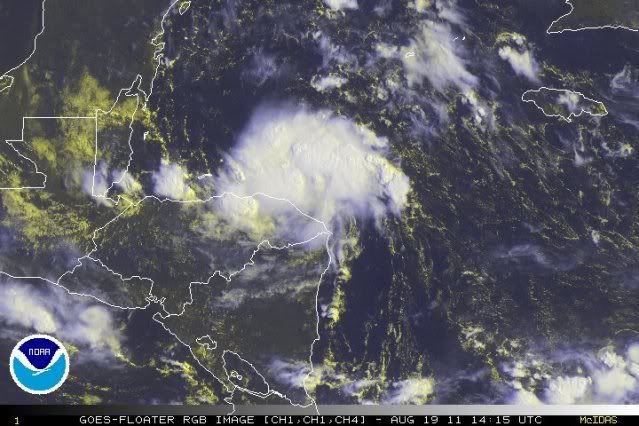
Proximity to land not bothering this very much. Notice the outflow cirrus starting to show on northwestern side.
0 likes
Re: ATL : EIGHT - Tropical Depression - Discussion
wxman57 wrote:That latest vortex message reported only 38 kts as the max FL wind in the NE quadrant. That's a bit low. I still don't trust those SFMR winds as far as I can throw them, so to speak. They're consistently well above the FL winds. It does appear borderline for upgrade now. They could go either way. If not Harvey now, it should be Harvey this afternoon.
PS: No upgrade - still TD 8
I saw 40kt as max winds in the last vortex:
P. AF302 0308A CYCLONE OB 17
MAX FL WIND 40 KT N QUAD 13:44:20Z
But it's probably on the verge...those extra ticks of latitude should give it room to become Harvey. And it looks like we will go 8/0/0
0 likes


-
Aric Dunn
- Category 5

- Posts: 21238
- Age: 43
- Joined: Sun Sep 19, 2004 9:58 pm
- Location: Ready for the Chase.
- Contact:
Well with it staying over water now... and being a small system in a good environment... Would not be surprised to see it become a pretty strong TS..
0 likes
Note: If I make a post that is brief. Please refer back to previous posts for the analysis or reasoning. I do not re-write/qoute what my initial post said each time.
If there is nothing before... then just ask
Space & Atmospheric Physicist, Embry-Riddle Aeronautical University,
I believe the sky is falling...
If there is nothing before... then just ask
Space & Atmospheric Physicist, Embry-Riddle Aeronautical University,
I believe the sky is falling...
-
ozonepete
- Professional-Met
- Posts: 4743
- Joined: Mon Sep 07, 2009 3:23 pm
- Location: From Ozone Park, NYC / Now in Brooklyn, NY
Re: ATL : EIGHT - Tropical Depression - Discussion
I see they expect a TS by this evening. In addition they have shifted the track northward so that it doesn't landfall on "main land" until Belize, although it will hit the Bay Islands off the Honduran coast later today or tonight. Here's some of the discussion:
THE NEW FORECAST TRACK ALLOWS THE CYCLONE TO SPEND MORE TIME OVER WATER THAN PREVIOUSLY EXPECTED...AND THIS REQUIRES REVISING THE INTENSITY FORECAST UPWARD. THE NEW INTENSITY FORECAST CALLS FOR THE SYSTEM TO BECOME A TROPICAL STORM IN 12 HR OR LESS AND TO REACH A PEAK INTENSITY OF 45 KT NEAR THE TIME OF LANDFALL IN BELIZE.
THIS FORECAST IS A COMPROMISE BETWEEN THE WEAKER GFDL/HWRF MODELS AND THE STRONGER SHIPS/LGEM MODELS.
THE NEW FORECAST REQUIRES SIGNIFICANT CHANGES TO THE WATCHES AND WARNINGS AT THIS TIME.
Code: Select all
FORECAST POSITIONS AND MAX WINDS

INIT  19/1500Z 16.1N  83.7W   30 KT  35 MPH
 12H  20/0000Z 16.3N  85.0W   35 KT  40 MPH
 24H  20/1200Z 16.7N  86.8W   40 KT  45 MPH
 36H  21/0000Z 17.1N  88.6W   45 KT  50 MPH...INLAND
 48H  21/1200Z 17.5N  90.5W   30 KT  35 MPH...INLAND
 72H  22/1200Z 18.0N  94.5W   20 KT  25 MPH...POST-TROP/REMNT LOW
 96H  23/1200Z...DISSIPATED
0 likes
Re:
Aric Dunn wrote:Well with it staying over water now... and being a small system in a good environment... Would not be surprised to see it become a pretty strong TS..
Yeah the land also tends to help tighten up the southern section to the LLC on this track, so yeah could well get in the 50-60kt range.
0 likes
Personal Forecast Disclaimer:
The posts in this forum are NOT official forecast and should not be used as such. They are just the opinion of the poster and may or may not be backed by sound meteorological data. They are NOT endorsed by any professional institution or storm2k.org. For official information, please refer to the NHC and NWS products
The posts in this forum are NOT official forecast and should not be used as such. They are just the opinion of the poster and may or may not be backed by sound meteorological data. They are NOT endorsed by any professional institution or storm2k.org. For official information, please refer to the NHC and NWS products
Re: ATL : EIGHT - Tropical Depression - Discussion
Good thing for Belize this was an unfavorable year so far.
0 likes
-
ozonepete
- Professional-Met
- Posts: 4743
- Joined: Mon Sep 07, 2009 3:23 pm
- Location: From Ozone Park, NYC / Now in Brooklyn, NY
Re: ATL : EIGHT - Tropical Depression - Discussion
Unfortunately for them, though, most of Belize will get the right side (stronger side) of an intensifying storm. Let's hope it doesn't intensify too much.
0 likes
-
plasticup
Re: ATL : EIGHT - Tropical Depression - Discussion
Presumably rain will be a bigger threat than wind, especially as the storm encounters the mountains.
0 likes
-
Hylian Auree

- Tropical Storm

- Posts: 150
- Age: 33
- Joined: Thu Dec 02, 2010 7:01 pm
- Location: Willemstad, Curaçao
- Contact:
-
Aric Dunn
- Category 5
- Posts: 21238
- Age: 43
- Joined: Sun Sep 19, 2004 9:58 pm
- Location: Ready for the Chase.
- Contact:
very interesting. convection firing on west and east side.. rotating pretty quick around center.. should see a significant burst over the next couple hours and both those areas wrap around.
http://weather.msfc.nasa.gov/GOES/goeseastconus.html
http://weather.msfc.nasa.gov/GOES/goeseastconus.html
0 likes
Note: If I make a post that is brief. Please refer back to previous posts for the analysis or reasoning. I do not re-write/qoute what my initial post said each time.
If there is nothing before... then just ask
Space & Atmospheric Physicist, Embry-Riddle Aeronautical University,
I believe the sky is falling...
If there is nothing before... then just ask
Space & Atmospheric Physicist, Embry-Riddle Aeronautical University,
I believe the sky is falling...
-
hurricanefloyd5

- Category 5
- Posts: 1659
- Age: 45
- Joined: Sun May 02, 2004 10:53 am
- Location: Spartanburg
- Contact:
Who is online
Users browsing this forum: No registered users and 13 guests