ATL : HARVEY - Tropical Depression - Discussion
Moderator: S2k Moderators
-
dwsqos2
Re: ATL : INVEST 93L - Discussion
I actually see evidence of low-level southerly winds on shortwave south of 93L suggesting at least improved inflow and a sharper surface trough.
0 likes

Re: ATL : INVEST 93L - Discussion
Deep convection over the center, should help pop the LLC down. Looks like it has finally moistened the environment to go.

The posts in this forum are NOT official forecast and should not be used as such. They are just the opinion of the poster and may or may not be backed by sound meteorological data. They are NOT endorsed by any professional institution or storm2k.org. For official information, please refer to the NHC and NWS products.
The posts in this forum are NOT official forecast and should not be used as such. They are just the opinion of the poster and may or may not be backed by sound meteorological data. They are NOT endorsed by any professional institution or storm2k.org. For official information, please refer to the NHC and NWS products.
0 likes

Re: ATL : INVEST 93L - Discussion
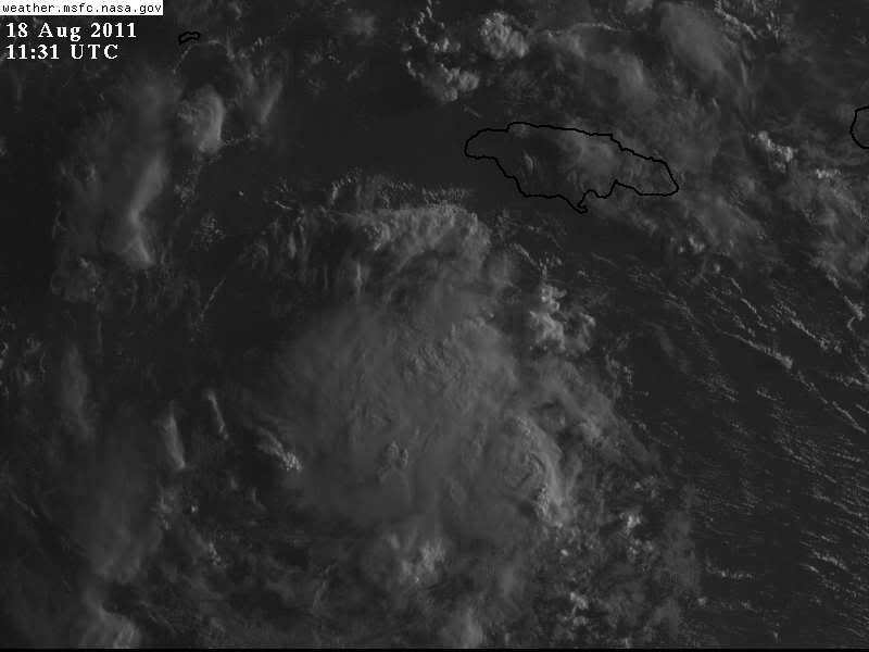
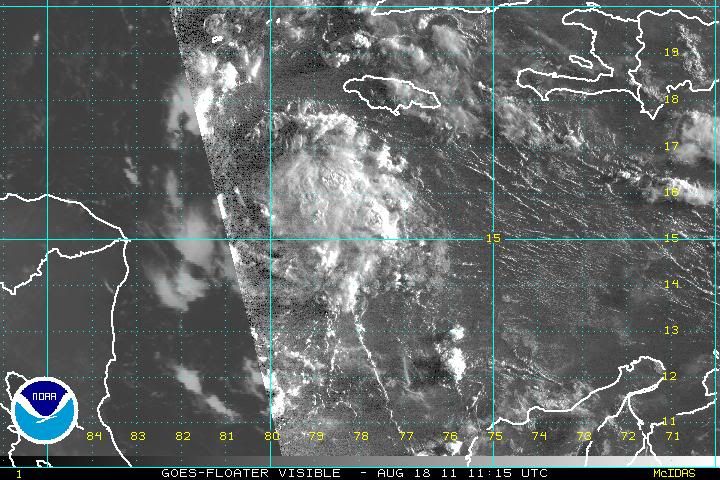
Moderate convection is firing very close to the LLC.
http://rammb.cira.colostate.edu/products/tc_realtime/loop.asp?product=4kmsrbdc&storm_identifier=AL932011&starting_image=2011AL93_4KMSRBDC_201108180315.jpg
Starting to look like a TD on 700mb, but SCAT not quite to the surface from latest data.
http://rammb.cira.colostate.edu/products/tc_realtime/products/storms/2011AL93/MPSATWND/2011AL93_MPSATWND_201108180600_SWHR.GIF
http://rammb.cira.colostate.edu/products/tc_realtime/products/storms/2011AL93/MPSATWND/2011AL93_MPSATWND_201108180600_SCAT.GIF
200mb vorticity has moved farther to the west indicating the effect of yesterday's subsidence is now diminishing.
http://tropic.ssec.wisc.edu/real-time/atlantic/winds/wg8vor1.GIF
However, it is still trying to work out the dry air that was introduced from the mid-level into the boundary layer as seen on MIMIC-TPW.
http://cimss.ssec.wisc.edu/tropic/real-time/tpw2/natl/anim/latest72hrs.gif
If convection continues near the LLC for the next few hours, I would say there is an excellent chance we will have a TD by this evening.
I don't see a fast ramp up since 93L is tracking away from the anti-cyclone.
However, if heavy convection fires later, the anti-cyclone could get re-positioned.
0 likes
-
cycloneye

- Admin

- Posts: 149431
- Age: 69
- Joined: Thu Oct 10, 2002 10:54 am
- Location: San Juan, Puerto Rico
Re: ATL : INVEST 93L - Discussion
GCANE wrote:Moderate convection is firing very close to the LLC.
http://rammb.cira.colostate.edu/products/tc_realtime/loop.asp?product=4kmsrbdc&storm_identifier=AL932011&starting_image=2011AL93_4KMSRBDC_201108180315.jpg
Starting to look like a TD on 700mb, but SCAT not quite to the surface from latest data.
http://rammb.cira.colostate.edu/products/tc_realtime/products/storms/2011AL93/MPSATWND/2011AL93_MPSATWND_201108180600_SWHR.GIF
http://rammb.cira.colostate.edu/products/tc_realtime/products/storms/2011AL93/MPSATWND/2011AL93_MPSATWND_201108180600_SCAT.GIF
200mb vorticity has moved farther to the west indicating the effect of yesterday's subsidence is now diminishing.
http://tropic.ssec.wisc.edu/real-time/atlantic/winds/wg8vor1.GIF
However, it is still trying to work out the dry air that was introduced from the mid-level into the boundary layer as seen on MIMIC-TPW.
http://cimss.ssec.wisc.edu/tropic/real-time/tpw2/natl/anim/latest72hrs.gif
If convection continues near the LLC for the next few hours, I would say there is an excellent chance we will have a TD by this evening.
I don't see a fast ramp up since 93L is tracking away from the anti-cyclone.
However, if heavy convection fires later, the anti-cyclone could get re-positioned.
It also looks like it will track north of Nicaragua/Honduras,and that gives it more time in those very warm waters to develop more before landfall in Belize.
0 likes
Visit the Caribbean-Central America Weather Thread where you can find at first post web cams,radars
and observations from Caribbean basin members Click Here
and observations from Caribbean basin members Click Here

Yeah I agree we will have our next system within the enxt 12hrs if then deeper convectionm keeps itself over the system.
0 likes
Personal Forecast Disclaimer:
The posts in this forum are NOT official forecast and should not be used as such. They are just the opinion of the poster and may or may not be backed by sound meteorological data. They are NOT endorsed by any professional institution or storm2k.org. For official information, please refer to the NHC and NWS products
The posts in this forum are NOT official forecast and should not be used as such. They are just the opinion of the poster and may or may not be backed by sound meteorological data. They are NOT endorsed by any professional institution or storm2k.org. For official information, please refer to the NHC and NWS products

-
cycloneye
- Admin
- Posts: 149431
- Age: 69
- Joined: Thu Oct 10, 2002 10:54 am
- Location: San Juan, Puerto Rico
Re: ATL : INVEST 93L - Discussion
80%
SATELLITE IMAGERY INDICATES THAT SHOWER ACTIVITY ASSOCIATED WITH A
TROPICAL WAVE LOCATED ABOUT 200 MILES SOUTH-SOUTHWEST OF JAMAICA IS
BECOMING BETTER ORGANIZED. SURFACE OBSERVATIONS ACROSS THIS REGION
ALSO INDICATE THAT PRESSURES ARE FALLING. IF CURRENT TRENDS
CONTINUE...A TROPICAL DEPRESSION COULD FORM LATER TODAY OR TONIGHT
AS THE SYSTEM MOVES GENERALLY WESTWARD AT AROUND 15 MPH. THIS
SYSTEM HAS A HIGH CHANCE...80 PERCENT...OF BECOMING A TROPICAL
CYCLONE DURING THE NEXT 48 HOURS. INTERESTS ALONG THE COASTS OF
HONDURAS...NICARAGUA...BELIZE...AND THE EASTERN YUCATAN PENINSULA
SHOULD MONITOR THE PROGRESS OF THIS DISTURBANCE. AN AIR FORCE
RESERVE UNIT AIRCRAFT IS SCHEDULED TO INVESTIGATE THE WAVE THIS
AFTERNOON.
0 likes
Visit the Caribbean-Central America Weather Thread where you can find at first post web cams,radars
and observations from Caribbean basin members Click Here
and observations from Caribbean basin members Click Here
Looks like a classic W.Caribbean late brewer that needs the W.Caribbean to form.
Suspect this will be a TD today and maybe a quick fire TS tomorrow before it gets a real close approach.
Suspect this will be a TD today and maybe a quick fire TS tomorrow before it gets a real close approach.
0 likes
Personal Forecast Disclaimer:
The posts in this forum are NOT official forecast and should not be used as such. They are just the opinion of the poster and may or may not be backed by sound meteorological data. They are NOT endorsed by any professional institution or storm2k.org. For official information, please refer to the NHC and NWS products
The posts in this forum are NOT official forecast and should not be used as such. They are just the opinion of the poster and may or may not be backed by sound meteorological data. They are NOT endorsed by any professional institution or storm2k.org. For official information, please refer to the NHC and NWS products
-
Gustywind

- Category 5

- Posts: 12334
- Joined: Mon Sep 03, 2007 7:29 am
- Location: Baie-Mahault, GUADELOUPE
Here is a summary of the situation after the vigorous TWAVE who have brang numerous floodings in Guadeloupe...
 http://www.microsofttranslator.com/bv.a ... 135184.php
150 MM... AND THIS IS NOT FINISHED!
M.A. France-Antilles Guadeloupe17.08.2011
(Sylvère SELBONNE)
He fell from the millions of litres of water on the Guadeloupe yesterday. Several districts were flooded. The orange alert is in effect still this morning.
Two days of continuous rain, or almost. The wave tropical No. 27 and storms that it generates have caused their lot of disturbances, yesterday, nothing really dramatic is to deplore. Program, the kilometres of Cap associated with portions of road flooded and serious climbs of water in typical areas.
It is 13 hours yesterday that weather France took the decision to move from the stage of yellow alert to orange alert for heavy rain and thunderstorms. At this time, he had already fallen, in 24 hours, a minimum of 50 mm of water (50 litres / m2) to Marie-Galante, 80 and 120 on the high-land, with spikes to 150 mm on the relief of the Basse-Terre. Saturated soil absorbed more nothing and is feared rivers and gullies overflows.
Traffic was very tricky in places, particularly on the bypass, between the Gabarre bridge and Petit-Bourg: in early afternoon, it took an hour to make these a few unfortunate kilometres, then yet that a good part of the drivers opted to traverse paths. Reported difficulties in Arnouville, Petit-Bourg, Morne-à - water and in les Abymes, on the road to the riviera, in the direction of guava, shroud, between Sainte-Rose and Lamentin. It is on Morne-à - the water and mould that the situation was the most embarrassing, with roads flooded and impassable on pavement, Bellevue, Chazeau, Bosrédon. Submerged engines of motorists who have assumed their chassis height already had dozens. And firefighters (read here) chômaient not.
Another wave approach
It is in this same period, the early afternoon, that the situation is tough at the Boucan. The great river reached its rating alert, flooding several surrounding areas. It was feared a possible closure of the bridge, which would have made the unmanageable situation for residents of Sainte-Rose. Because, as early as 13 hours, roads of Guadeloupe had announced the closure of the road to the crossing from 18 hours. "There are whole sections of Cliff which are very unstable, noted Sully Pandolf (roads of Guadeloupe).".
The risk of rockfall is really important. "At 18 hours, the situation was, of course, embarrassing, but nothing insurmountable was emerging.
The orange alert runs normally until the end of afternoon of today. The risk is described as "strong" and impact "important".
Note that there will be little respite: medium-term weather France monitors a large mass of clouds out of Africa, tends to being confused with the ITCZ (read above). "We have, it is true, a small concern about this wave, but not because the ITCZ goes back to her, told yesterday Norbert Aouizérats, head of the centre of the Raizet.". These two elements are not related. This time of year is a period of uplift of the ITCZ, and this phenomenon has no particular effect on the wave. "The wave nevertheless has some potential for organization. If it was - "it is much too early to know...". "- it may interest us next weekend, possibly as a depression.
Many have presumed the height of their chassis. Drowned engines number in the dozens, and firefighters had to intervene to rescue blocked drivers. (Sylvère SELBONNE)
-EVIDENCE: "I've lost everything."
Micheline ramsay and her husband, Raymond dias, live in Arnouville (Baie-Mahault). Yesterday, the water is entered into their house.
The water is mounted high in the parts before reflow (Sy.) (S)
"I was going to lunch." It's my husband! He told me to be immediately out of the House, that the water came. "Glamorous 50 Micheline Ramsay has feet in water. Yet, it has dropped gradually when we arrive on the spot. It's just after the gateway of Arnouville, cited to the right, any small roadside, a beautiful House of ten pieces, beautiful place, surrounded by massive. There, the House took water.
"The only ones who have come are constables...". »
It was around 15 hours. "The water is mounted very quickly." It is because of the ravine, which is never long–term. It has clogged the underside of the little bridge that passes here and when the rubbish cap jumped, the water is mounted far home, drowning, before invading the neighbouring houses. »
Micheline Ramsay supported. "I called the fire department but they said that was not within their jurisdiction, the need to call technical services." At this time (18 hours), one town hall not to is moved. The Mayor knows come and see us when there will be elections. But when you need something, person. Not even an elected, not one administrative. The only ones who have come are constables. »
Micheline, Raymond, more than four other people - "children, small children who live with us," she said, did not know, yesterday evening, if they could stay in their homes or had to evacuate... The smell, the fear of a sudden upwelling with rain expected. "Friends only came assist us...". ", she said. But, Micheline (a) of the spring!
Micheline deplores the Town Hall is not shown.
-Very solicited firefighters
Contacted later in the day yesterday, the fire alert processing centre does not lamented victim or injured following the floods. However, firefighters have been busy, especially in the afternoon. They were very requested, inter alia on the areas of Sainte-Rose, guava, Petit-Bourg - at Arnouville including-, but also to the mould at Chateau-Gaillard and paved. There, aquatic rescue (VAS) of the departmental fire and rescue (Sdis) Service had to rescue a motorist trapped by the rising waters. They have her out of his car. They had to proceed here and security warnings there. For most of the motorists in difficulty. The Dragon of the civil security helicopter did not intervene for rescues and the hoists, but remained on alert in case where. As the police and gendarmerie services. An intelligence unit was activated, yesterday, in Prefecture to follow the evolution of the situation in connection with the Commons and to coordinate the interventions of the different services of the State.
-The ITCZ, you know?
(S.B.)
The area of the Intertropical Convergence corresponds to the meteorological equator: it is the area of meetings between the hot winds, the trade winds, with two hemispheres. It is characterized by the significant formation of cumulonimbus clouds, clouds formed by hot and humid conditions on the surface and cold conditions and dry aloft. It recognizes the ITCZ by its cloud band surrounding the Earth. Among the sailors, this area is known as the doldrums. The meteorological Equator is not a stable band: it moves according to the periods of the year and the geographical areas. The ITCZ can move more than 1000 kilometres between summer and winter. Currently, the ITCZ is bulging.
0 likes
Re: ATL : INVEST 93L - Discussion
dwsqos2 wrote:I actually see evidence of low-level southerly winds on shortwave south of 93L suggesting at least improved inflow and a sharper surface trough.
Yeah, there it is.
I am also starting to see some NW to SE moving low clouds in the SW quadrant of the system, but far out.
0 likes
-
cycloneye
- Admin
- Posts: 149431
- Age: 69
- Joined: Thu Oct 10, 2002 10:54 am
- Location: San Juan, Puerto Rico
Re: ATL : INVEST 93L - Discussion
12z Best Track
AL, 93, 2011081812, , BEST, 0, 158N, 794W, 25, 1008, DB
AL, 93, 2011081812, , BEST, 0, 158N, 794W, 25, 1008, DB
0 likes
Visit the Caribbean-Central America Weather Thread where you can find at first post web cams,radars
and observations from Caribbean basin members Click Here
and observations from Caribbean basin members Click Here
-
ozonepete
- Professional-Met

- Posts: 4743
- Joined: Mon Sep 07, 2009 3:23 pm
- Location: From Ozone Park, NYC / Now in Brooklyn, NY
Re: ATL : INVEST 93L - Discussion
GCANE wrote:Moderate convection is firing very close to the LLC.
http://rammb.cira.colostate.edu/products/tc_realtime/loop.asp?product=4kmsrbdc&storm_identifier=AL932011&starting_image=2011AL93_4KMSRBDC_201108180315.jpg
Starting to look like a TD on 700mb, but SCAT not quite to the surface from latest data.
http://rammb.cira.colostate.edu/products/tc_realtime/products/storms/2011AL93/MPSATWND/2011AL93_MPSATWND_201108180600_SWHR.GIF
http://rammb.cira.colostate.edu/products/tc_realtime/products/storms/2011AL93/MPSATWND/2011AL93_MPSATWND_201108180600_SCAT.GIF
200mb vorticity has moved farther to the west indicating the effect of yesterday's subsidence is now diminishing.
http://tropic.ssec.wisc.edu/real-time/atlantic/winds/wg8vor1.GIF
However, it is still trying to work out the dry air that was introduced from the mid-level into the boundary layer as seen on MIMIC-TPW.
http://cimss.ssec.wisc.edu/tropic/real-time/tpw2/natl/anim/latest72hrs.gif
If convection continues near the LLC for the next few hours, I would say there is an excellent chance we will have a TD by this evening.
I don't see a fast ramp up since 93L is tracking away from the anti-cyclone.
However, if heavy convection fires later, the anti-cyclone could get re-positioned.
Very nice analysis, as usual, GCANE. Pretty good convection already with some banding now. I think we could see a TS by 5PM.
Last edited by ozonepete on Thu Aug 18, 2011 7:48 am, edited 1 time in total.
0 likes
-
DESTRUCTION5

- Category 5
- Posts: 4430
- Age: 44
- Joined: Wed Sep 03, 2003 11:25 am
- Location: Stuart, FL
Re: ATL : INVEST 93L - Discussion
ozonepete wrote:GCANE wrote:Moderate convection is firing very close to the LLC.
http://rammb.cira.colostate.edu/products/tc_realtime/loop.asp?product=4kmsrbdc&storm_identifier=AL932011&starting_image=2011AL93_4KMSRBDC_201108180315.jpg
Starting to look like a TD on 700mb, but SCAT not quite to the surface from latest data.
http://rammb.cira.colostate.edu/products/tc_realtime/products/storms/2011AL93/MPSATWND/2011AL93_MPSATWND_201108180600_SWHR.GIF
http://rammb.cira.colostate.edu/products/tc_realtime/products/storms/2011AL93/MPSATWND/2011AL93_MPSATWND_201108180600_SCAT.GIF
200mb vorticity has moved farther to the west indicating the effect of yesterday's subsidence is now diminishing.
http://tropic.ssec.wisc.edu/real-time/atlantic/winds/wg8vor1.GIF
However, it is still trying to work out the dry air that was introduced from the mid-level into the boundary layer as seen on MIMIC-TPW.
http://cimss.ssec.wisc.edu/tropic/real-time/tpw2/natl/anim/latest72hrs.gif
If convection continues near the LLC for the next few hours, I would say there is an excellent chance we will have a TD by this evening.
I don't see a fast ramp up since 93L is tracking away from the anti-cyclone.
However, if heavy convection fires later, the anti-cyclone could get re-positioned.
Very nice analysis, as usual, GCANE. Pretty good convection already with some banding now. I think we could see a TS by 5PM.
I think we may already have that if not a Depression already IMO..Albeit a little guy.
0 likes
GATOR NATION IS E V E R Y W H E R E !

Re: ATL : INVEST 93L - Discussion
ozonepete wrote:
Very nice analysis, as usual, GCANE. Pretty good convection already with some banding now. I think we could see a TS by 5PM.
Thanks Phil.
What's your take on its track?
0 likes
Re: ATL : INVEST 93L - Discussion
cycloneye wrote:12z Best Track
AL, 93, 2011081812, , BEST, 0, 158N, 794W, 25, 1008, DB
A bit slower and a bit to the right
Code: Select all
AL, 93, 2011081700,   , BEST,   0, 144N,  694W,  25, 1010
AL, 93, 2011081706,   , BEST,   0, 147N,  713W,  25, 1010
AL, 93, 2011081712,   , BEST,   0, 149N,  733W,  25, 1009
AL, 93, 2011081718,   , BEST,   0, 151N,  749W,  25, 1010
AL, 93, 2011081800,   , BEST,   0, 153N,  765W,  25, 1009
AL, 93, 2011081806,   , BEST,   0, 155N,  780W,  25, 1009
AL, 93, 2011081812,   , BEST,   0, 158N,  794W,  25, 1008
0 likes

Re: ATL : INVEST 93L - Discussion
Does anyone know what the current Dvorak number is for invest 93l?
0 likes
"People might not get all they work for in this world, but they must certainly work for all they get."- Frederick Douglass
-
HURAKAN

- Professional-Met
- Posts: 46084
- Age: 39
- Joined: Thu May 20, 2004 4:34 pm
- Location: Key West, FL
- Contact:
Re: ATL : INVEST 93L - Discussion
AHS2011 wrote:Does anyone know what the current Dvorak number is for invest 93l?
18/1145 UTC 15.8N 78.7W T2.0/2.0 93L -- Atlantic
0 likes
Re: ATL : INVEST 93L - Discussion
Thanks HURAKAN. Also, new west-northwest movement at 16 MPH. Does this mean that this storm will miss the coasts of CA? And could rapid intensification go underway once it forms?
0 likes
"People might not get all they work for in this world, but they must certainly work for all they get."- Frederick Douglass
Who is online
Users browsing this forum: No registered users and 23 guests