ATL : HARVEY - Tropical Depression - Discussion

Moderator: S2k Moderators

Message
Author
User avatar
cycloneye
Admin
Admin
Posts: 145336
Age: 68
Joined: Thu Oct 10, 2002 10:54 am
Location: San Juan, Puerto Rico

Re:

#1021 Postby cycloneye » Tue Aug 16, 2011 10:11 pm

Gustywind wrote:Since 5PM things have return to normal. We can have a good breathe for now, thanks :). Hope that the night will be calm but that's another story.


That is great news from the butterfly island. Now we have to see how the folks downstream in the Caribbean may be affected,especially our friend BZSTORM in Belize.
0 likes   
Visit the Caribbean-Central America Weather Thread where you can find at first post web cams,radars
and observations from Caribbean basin members Click Here

ozonepete
Professional-Met
Professional-Met
Posts: 4743
Joined: Mon Sep 07, 2009 3:23 pm
Location: From Ozone Park, NYC / Now in Brooklyn, NY

Re: ATL : INVEST 93L - Discussion

#1022 Postby ozonepete » Tue Aug 16, 2011 10:14 pm

good luck to all of you. so far this has caused more trouble than it looked like it could...
0 likes   

User avatar
Gustywind
Category 5
Category 5
Posts: 12334
Joined: Mon Sep 03, 2007 7:29 am
Location: Baie-Mahault, GUADELOUPE

Re: Re:

#1023 Postby Gustywind » Tue Aug 16, 2011 10:19 pm

cycloneye wrote:
Gustywind wrote:Since 5PM things have return to normal. We can have a good breathe for now, thanks :). Hope that the night will be calm but that's another story.


That is great news from the butterfly island. Now we have to see how the folks downstream in the Caribbean may be affected,especially our friend BZSTORM in Belize.

Thanks for this post Cycloneye. Even if we're always in Orange alert, looks like a modest improvement is occuring for tonight. Yeah let's see what could happens for our others friend in the Carib hoping for the best.
0 likes   

User avatar
SouthDadeFish
Professional-Met
Professional-Met
Posts: 2835
Joined: Thu Sep 23, 2010 2:54 pm
Location: Miami, FL
Contact:

#1024 Postby SouthDadeFish » Tue Aug 16, 2011 10:28 pm

93L looks pretty anemic right now:

Image

I'm surprised convection has begun to fire yet...
0 likes   

User avatar
South Texas Storms
Professional-Met
Professional-Met
Posts: 4226
Joined: Thu Jun 24, 2010 12:28 am
Location: Houston, TX

Re: ATL : INVEST 93L - Discussion

#1025 Postby South Texas Storms » Tue Aug 16, 2011 10:32 pm

:uarrow: Convection has begun to pop up the last few nights at around 6z. We will see if that happens tonight as well.
0 likes   

User avatar
SouthDadeFish
Professional-Met
Professional-Met
Posts: 2835
Joined: Thu Sep 23, 2010 2:54 pm
Location: Miami, FL
Contact:

Re: ATL : INVEST 93L - Discussion

#1026 Postby SouthDadeFish » Tue Aug 16, 2011 10:39 pm

South Texas Storms wrote::uarrow: Convection has begun to pop up the last few nights at around 6z. We will see if that happens tonight as well.


If it wants to develop though, the diurnal cycles can't affect it this much.
0 likes   

User avatar
South Texas Storms
Professional-Met
Professional-Met
Posts: 4226
Joined: Thu Jun 24, 2010 12:28 am
Location: Houston, TX

Re: ATL : INVEST 93L - Discussion

#1027 Postby South Texas Storms » Tue Aug 16, 2011 10:43 pm

SouthDadeFish wrote:
South Texas Storms wrote::uarrow: Convection has begun to pop up the last few nights at around 6z. We will see if that happens tonight as well.


If it wants to develop though, the diurnal cycles can't affect it this much.


True, but I don't think it will develop until it slows down in the western Caribbean in a few days, if it does at all.
0 likes   

User avatar
HURAKAN
Professional-Met
Professional-Met
Posts: 46086
Age: 38
Joined: Thu May 20, 2004 4:34 pm
Location: Key West, FL
Contact:

Re: ATL : INVEST 93L - Discussion

#1028 Postby HURAKAN » Tue Aug 16, 2011 10:44 pm

SouthDadeFish wrote:
South Texas Storms wrote::uarrow: Convection has begun to pop up the last few nights at around 6z. We will see if that happens tonight as well.


If it wants to develop though, the diurnal cycles can't affect it this much.


Until it develops a well-defined LLC, convection will come and go with the cycles.
0 likes   

User avatar
Macrocane
Category 5
Category 5
Posts: 4218
Age: 36
Joined: Sun May 24, 2009 5:35 pm
Location: El Salvador

Re: ATL : INVEST 93L - Discussion

#1029 Postby Macrocane » Tue Aug 16, 2011 10:49 pm

The posts in this forum are NOT official forecast and should not be used as such. They are just the opinion of the poster and may or may not be backed by sound meteorological data. They are NOT endorsed by any professional institution or storm2k.org. For official information, please refer to the NHC and NWS products.


If there was a LLC under the convection and a CDO in the center of those rainbands we would have a nice looking tropical cyclone, but it is lacking both things :wink: Anyway, if conditions are really that good as SHIPS is indicating it has a good chance to develop into a moderate TS in a couple of days.
0 likes   

Brent
S2K Supporter
S2K Supporter
Posts: 38090
Age: 36
Joined: Sun May 16, 2004 10:30 pm
Location: Tulsa Oklahoma
Contact:

Re: ATL : INVEST 93L - Discussion

#1030 Postby Brent » Wed Aug 17, 2011 12:39 am

CLOUDINESS AND SHOWERS ASSOCIATED WITH A TROPICAL WAVE OVER THE
CENTRAL CARIBBEAN HAVE BECOME A LITTLE BETTER ORGANIZED OVER THE
PAST 24 HOURS. HOWEVER...THERE ARE STILL NO SIGNS OF A SURFACE
CIRCULATION AND PRESSURES ARE NOT FALLING IN THIS REGION. THIS WAVE
IS MOVING WESTWARD AT 15 TO 20 MPH...AND IT HAS THE POTENTIAL FOR
SOME SLOW DEVELOPMENT BEFORE IT MOVES OVER CENTRAL AMERICA IN A FEW
DAYS. THIS SYSTEM HAS A MEDIUM CHANCE...30 PERCENT...OF BECOMING A
TROPICAL CYCLONE DURING THE NEXT 48 HOURS.
0 likes   
#neversummer

User avatar
KWT
Category 5
Category 5
Posts: 31415
Joined: Tue Aug 17, 2004 11:02 am
Location: UK!!!

#1031 Postby KWT » Wed Aug 17, 2011 4:16 am

Well got a medium chance now, really it should start to feel the effects of the of the W.Caribbean soon I'd have thought if its going to ever get going.

Mid level circulation looks half decent.
0 likes   
Personal Forecast Disclaimer:
The posts in this forum are NOT official forecast and should not be used as such. They are just the opinion of the poster and may or may not be backed by sound meteorological data. They are NOT endorsed by any professional institution or storm2k.org. For official information, please refer to the NHC and NWS products

User avatar
KWT
Category 5
Category 5
Posts: 31415
Joined: Tue Aug 17, 2004 11:02 am
Location: UK!!!

#1032 Postby KWT » Wed Aug 17, 2011 4:26 am

00z ECM still weakly develops this, mayb e a TD/weak TS forecasted by it before it runs it into CA.
0 likes   
Personal Forecast Disclaimer:
The posts in this forum are NOT official forecast and should not be used as such. They are just the opinion of the poster and may or may not be backed by sound meteorological data. They are NOT endorsed by any professional institution or storm2k.org. For official information, please refer to the NHC and NWS products

User avatar
Gustywind
Category 5
Category 5
Posts: 12334
Joined: Mon Sep 03, 2007 7:29 am
Location: Baie-Mahault, GUADELOUPE

#1033 Postby Gustywind » Wed Aug 17, 2011 4:45 am

Hey what is that east of Martinica?, a big blob moving towards the Windwards/Leewards islands? Anyone noticed that? No mention of a twave in the last TWD.
Image
0 likes   

User avatar
Gustywind
Category 5
Category 5
Posts: 12334
Joined: Mon Sep 03, 2007 7:29 am
Location: Baie-Mahault, GUADELOUPE

#1034 Postby Gustywind » Wed Aug 17, 2011 4:51 am

IR sat pic of the Lesser Antilles
Image
0 likes   

User avatar
GCANE
S2K Supporter
S2K Supporter
Posts: 11497
Joined: Mon Oct 22, 2007 8:03 am

Re: ATL : INVEST 93L - Discussion

#1035 Postby GCANE » Wed Aug 17, 2011 5:46 am

Looks like there is a small TUTT just to the SW of 93L; i.e. north of Panama.

WV showing mid-level dry air indicating the TUTT is creating subsidence (pushing cold, dry air down from the upper troposphere).

93L could struggle to fire convection today.


http://tropic.ssec.wisc.edu/real-time/a ... g8wvir.GIF

http://www.goes.noaa.gov/HURRLOOPS/huwvloop.html

http://www.ssd.noaa.gov/goes/flt/t1/flash-wv.html


Image
0 likes   

User avatar
GCANE
S2K Supporter
S2K Supporter
Posts: 11497
Joined: Mon Oct 22, 2007 8:03 am

Re: ATL : INVEST 93L - Discussion

#1036 Postby GCANE » Wed Aug 17, 2011 5:54 am

Here is the latest GOES sounding in the middle of the dry-slot at 15N 80W.

Looks like borderline CAPE and LI.

No convective cap.


Image
0 likes   

HurrMark
Category 2
Category 2
Posts: 769
Joined: Tue Aug 12, 2008 10:18 pm
Location: Somerville, MA

Re: ATL : INVEST 93L - Discussion

#1037 Postby HurrMark » Wed Aug 17, 2011 6:20 am

Well, there definitely seems to be more of a circulation...probably in the mid-levels, but the convection isn't that well organized. It could still develop, but the best chance it becoming a TS might not happen until the western Caribbean. And if it does, it will probably quickly run out of real estate before getting too strong (perhaps making it 8 for 8 without a hurricane).
0 likes   

User avatar
cycloneye
Admin
Admin
Posts: 145336
Age: 68
Joined: Thu Oct 10, 2002 10:54 am
Location: San Juan, Puerto Rico

Re: ATL : INVEST 93L - Discussion

#1038 Postby cycloneye » Wed Aug 17, 2011 6:37 am

30%

TROPICAL WEATHER OUTLOOK
NWS NATIONAL HURRICANE CENTER MIAMI FL
800 AM EDT WED AUG 17 2011

FOR THE NORTH ATLANTIC...CARIBBEAN SEA AND THE GULF OF MEXICO...

CLOUDINESS AND SHOWERS ASSOCIATED WITH A TROPICAL WAVE OVER THE
CENTRAL CARIBBEAN HAVE CHANGED LITTLE IN ORGANIZATION DURING PAST
SEVERAL HOURS. THERE ARE STILL NO SIGNS OF A SURFACE CIRCULATION
AND PRESSURES HAVE NOT FALLEN OVER THIS REGION. ENVIRONMENTAL
CONDITIONS REMAIN CONDUCIVE FOR SOME GRADUAL DEVELOPMENT OF THIS
WAVE DURING THE NEXT COUPLE OF DAYS. THIS SYSTEM HAS A MEDIUM
CHANCE...30 PERCENT...OF BECOMING A TROPICAL CYCLONE DURING THE
NEXT 48 HOURS AS IT MOVES WESTWARD AT 15 TO 20 MPH.

ELSEWHERE...TROPICAL CYCLONE FORMATION IS NOT EXPECTED DURING THE
NEXT 48 HOURS.

$$
FORECASTER KIMBERLAIN
0 likes   
Visit the Caribbean-Central America Weather Thread where you can find at first post web cams,radars
and observations from Caribbean basin members Click Here

ozonepete
Professional-Met
Professional-Met
Posts: 4743
Joined: Mon Sep 07, 2009 3:23 pm
Location: From Ozone Park, NYC / Now in Brooklyn, NY

Re: ATL : INVEST 93L - Discussion

#1039 Postby ozonepete » Wed Aug 17, 2011 6:39 am

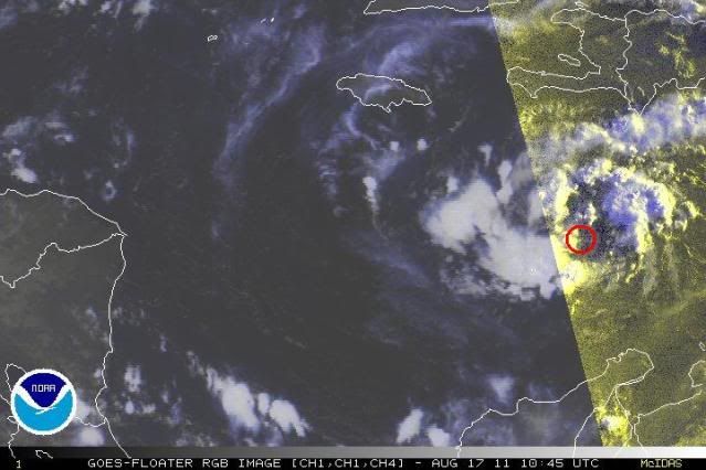
MLC quite apparent now. Looks like could be an LLC where I put the red circle. We'll see as sun is coming up.
Interesting how this has gone opposite to the normal DMAX at night and DMIN during day. And sure enough, it look's like convection is firing up again as daylight starts.

Image
0 likes   

User avatar
HURAKAN
Professional-Met
Professional-Met
Posts: 46086
Age: 38
Joined: Thu May 20, 2004 4:34 pm
Location: Key West, FL
Contact:

#1040 Postby HURAKAN » Wed Aug 17, 2011 7:02 am

0 likes   


Return to “2011”

Who is online

Users browsing this forum: No registered users and 4 guests