Another Disturbance?
Moderator: S2k Moderators
Forum rules

The posts in this forum are NOT official forecasts and should not be used as such. They are just the opinion of the poster and may or may not be backed by sound meteorological data. They are NOT endorsed by any professional institution or STORM2K. For official information, please refer to products from the National Hurricane Center and National Weather Service.
-
northjaxpro

- S2K Supporter

- Posts: 8900
- Joined: Mon Sep 27, 2010 11:21 am
- Location: Jacksonville, FL
Actually, the portion of the surface trough currently near the Central Bahamas looks a bit better this morning with some convective build-up. Watching to see if convection will sustain itself through the course of the day.
0 likes
NEVER, EVER SAY NEVER in the tropics and weather in general, and most importantly, with life itself!!
________________________________________________________________________________________
Fay 2008 Beryl 2012 Debby 2012 Colin 2016 Hermine 2016 Julia 2016 Matthew 2016 Irma 2017 Dorian 2019
________________________________________________________________________________________
Fay 2008 Beryl 2012 Debby 2012 Colin 2016 Hermine 2016 Julia 2016 Matthew 2016 Irma 2017 Dorian 2019
-
painkillerr
- S2K Supporter
- Posts: 129
- Age: 70
- Joined: Wed Aug 25, 2010 5:17 pm
- Location: San Juan, PR

-
ozonepete
- Professional-Met

- Posts: 4743
- Joined: Mon Sep 07, 2009 3:23 pm
- Location: From Ozone Park, NYC / Now in Brooklyn, NY
Re:
painkillerr wrote:Any comments about these?
http://img812.imageshack.us/img812/5051/avnl816111200.jpg
Cape Verde season now begins in earnest. Those are quite nice looking easterly waves. The closer we get to September and then into the month itself the more likely those are to develop. The convection associated with them will ramp up and down for the next couple of days but they sure look healthy right now. There's high shear ahead of them east of the more northern islands but they may stay just south of it. The SAL is also far enough north of them that it shouldn't have much effect. SSTs are nice and high so I think they can develop if they stay south of 15 degrees or so, and it looks like they will. I will certainly be watching them from here on.
Of course you should always go to the global models such as GFS, ECMWF or CMC to see if they develop these areas down the road, although they frequently don't do well with analyzing or forecasting them when they're just initial waves. I usually check the model runs daily once the season reaches this point, though I haven't checked today.
0 likes
-
wxman57

- Moderator-Pro Met

- Posts: 23176
- Age: 68
- Joined: Sat Jun 21, 2003 8:06 pm
- Location: Houston, TX (southwest)
Re:
painkillerr wrote:Any comments about these?
http://img812.imageshack.us/img812/5051/avnl816111200.jpg
Those are not tropical waves, that's just spotty/transient thunderstorm activity embedded in the ITCZ/monsoon trof. Tropical cyclones rarely develop from such features.
0 likes
Re: Re:
wxman57 wrote:painkillerr wrote:Any comments about these?
http://img812.imageshack.us/img812/5051/avnl816111200.jpg
Those are not tropical waves, that's just spotty/transient thunderstorm activity embedded in the ITCZ/monsoon trof. Tropical cyclones rarely develop from such features.
Wxman, does that convection, although not related to waves show that the atmosphere is becoming more suitable development in the tropics?
0 likes
-
wxman57
- Moderator-Pro Met
- Posts: 23176
- Age: 68
- Joined: Sat Jun 21, 2003 8:06 pm
- Location: Houston, TX (southwest)
Re: Re:
RL3AO wrote:wxman57 wrote:painkillerr wrote:Any comments about these?
http://img812.imageshack.us/img812/5051/avnl816111200.jpg
Those are not tropical waves, that's just spotty/transient thunderstorm activity embedded in the ITCZ/monsoon trof. Tropical cyclones rarely develop from such features.
Wxman, does that convection, although not related to waves show that the atmosphere is becoming more suitable development in the tropics?
Oh, I don't know. It's nothing out of the ordinary. But having a few thunderstorms in the ITCZ vs. having none would seem to indicate that the atmosphere at least in the very deep tropics is becoming a little more unstable.
0 likes
-
ozonepete
- Professional-Met
- Posts: 4743
- Joined: Mon Sep 07, 2009 3:23 pm
- Location: From Ozone Park, NYC / Now in Brooklyn, NY
Re: Re:
wxman57 wrote:painkillerr wrote:Any comments about these?
http://img812.imageshack.us/img812/5051/avnl816111200.jpg
Those are not tropical waves, that's just spotty/transient thunderstorm activity embedded in the ITCZ/monsoon trof. Tropical cyclones rarely develop from such features.
Hey wxman, maybe the first one isn't, although it sure looked like an easterly wave as it came off the African coast, and the second one is labeled as a tropical wave by the OPC at 12Z this morning. That one was clearly an easterly wave that came off the African continent.

0 likes
-
ozonepete
- Professional-Met
- Posts: 4743
- Joined: Mon Sep 07, 2009 3:23 pm
- Location: From Ozone Park, NYC / Now in Brooklyn, NY
Re: Another Disturbance?
The convection on your satellite image, painkiller, is actually to the south and west of the tropical wave axis, so the convection you circled is not technically part of the wave, although it's common to see convection ahead of easterly waves when they first come off the African coast. I attached a close-up of the analysis and the text from the NHC tropical weather discussion today at 2PM. Wxman, I should have clarified that I wasn't saying the convection was the wave. 
TROPICAL WEATHER DISCUSSION
NWS NATIONAL HURRICANE CENTER MIAMI FL
205 PM EDT TUE AUG 16 2011
...TROPICAL WAVES...
WELL DEFINED TROPICAL WAVE IS MOVING W THROUGH THE CAPE VERDE ISLANDS ALONG 17N24W TO 11N27W AT 15 KT. SATELLITE IMAGERY SHOWS DISTINGUISHABLE LOW-LEVEL CYCLONIC FLOW AROUND THE WAVE AXIS WHICH MAY BE FORMING A LOW CENTER ON THE WAVE AXIS. THIS CYCLONIC FLOW IS ALSO EVIDENT IN SCATTEROMETER DATA. THE WAVE IS EMBEDDED WITHIN A SURGE OF DEEP LAYER MOISTURE EXTENDING TO 21N. WHILE NO DEEP CONVECTION IS IN CLOSE VICINITY OF THE WAVE...A CLUSTER OF MODERATE /STRONG CONVECTION IS SW OF IT FROM 7N-10N BETWEEN 28W-34W.
0 likes
-
ozonepete
- Professional-Met
- Posts: 4743
- Joined: Mon Sep 07, 2009 3:23 pm
- Location: From Ozone Park, NYC / Now in Brooklyn, NY
Re: Another Disturbance?
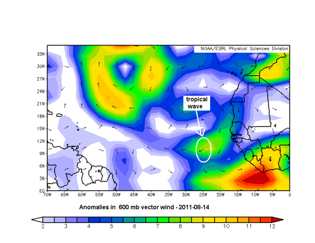
The current configuration of this wave is classic for waves as they move over the west African coast and the waters just east of it. The mid-level winds at about 650 mb, the Mid-level African Easterly Jet, cause convection to form out ahead of the surface and low-level wave axis. As the waves move further west the pattern often reverses due to lighter winds at mid-levels, and the convection will trail the surface wave axis. But right now the MLAEJ is stronger than normal – see the attached chart of current anomalies in the 600 mb wind (hard to get 650 mb charts!) – and while it is strong, especially stronger than normal, the convection remains ahead of the wave and it will have a better chance of developing, IF all other conditions for formation are positive.

0 likes
-
painkillerr
- S2K Supporter
- Posts: 129
- Age: 70
- Joined: Wed Aug 25, 2010 5:17 pm
- Location: San Juan, PR

Re: Re:
wxman57 wrote:
Those are not tropical waves, that's just spotty/transient thunderstorm activity embedded in the ITCZ/monsoon trof. Tropical cyclones rarely develop from such features.
I wonder if any tropical cyclones developed from spotty/transient thunderstorm activity embedded in the ITCZ/monsoon trof? I know that happens in the Western Pacific and South Indian Ocean since they come from monsoonal troughs and lows.
0 likes
-
SunnyThoughts
- Category 5

- Posts: 2263
- Joined: Wed Jul 09, 2003 12:42 pm
- Location: Pensacola, Florida
-
Aric Dunn
- Category 5
- Posts: 21238
- Age: 43
- Joined: Sun Sep 19, 2004 9:58 pm
- Location: Ready for the Chase.
- Contact:
looks like there is a small circ developing with the same area that was south of cuba couple days ago.. now nearing yucatan channel.. still could get something from it..
0 likes
Note: If I make a post that is brief. Please refer back to previous posts for the analysis or reasoning. I do not re-write/qoute what my initial post said each time.
If there is nothing before... then just ask
Space & Atmospheric Physicist, Embry-Riddle Aeronautical University,
I believe the sky is falling...
If there is nothing before... then just ask
Space & Atmospheric Physicist, Embry-Riddle Aeronautical University,
I believe the sky is falling...
-
HurricaneBelle

- S2K Supporter
- Posts: 1209
- Joined: Sun Aug 27, 2006 6:12 pm
- Location: Clearwater, FL
Re:
Aric Dunn wrote:looks like there is a small circ developing with the same area that was south of cuba couple days ago.. now nearing yucatan channel.. still could get something from it..
Yeah, I'd put it at about 21N, 84W. It'll be interesting to see if it clears the Yucatan; if it doesn't, it's so small it might dissipate over land.
0 likes
-
Bad_Hurricane
- Tropical Depression

- Posts: 93
- Joined: Fri Jun 25, 2010 4:45 pm
- Location: Zagreb, Croatia
- Contact:
Re: Another Disturbance?
Does anyone know what this is? 
Code: Select all
BEGIN
HPC_ATCF
invest_al852011.invest
FSTDA
R
U
040
010
0000
201108171410
NONE
NOTIFY=ATRP
END
    NONAME, AL, L, , , , , 85, 2011, TS, O, 2011052412, 9999999999, , , , , , WARNING, 5, AL852011
AL, 85, 2011052318,   , BEST,   0, 135N,  551W,  35, 1009, TS,  34, NEQ,   25,   25,   25,   25,
AL, 85, 2011052400,   , BEST,   0, 139N,  571W,  35, 1009, TS,   0,    ,    0,    0,    0,    0,
AL, 85, 2011052406,   , BEST,   0, 144N,  588W,  50, 1009, TS,  34, NEQ,   40,   40,   40,   40,
AL, 85, 2011052406,   , BEST,   0, 144N,  588W,  50, 1009, TS,  50, NEQ,   15,   15,   15,   15,
AL, 85, 2011052412,   , BEST,   0, 150N,  600W,  50, 1009, TS,  34, NEQ,   40,   40,   40,   40, 1010,  150,   0,   0,   0,   L,   0,    ,   0,   0,     NONAME, M,
AL, 85, 2011052412,   , BEST,   0, 150N,  600W,  50, 1009, TS,  50, NEQ,   25,   25,    0,    0, 1010,  150,   0,   0,   0,   L,   0,    ,   0,   0,     NONAME, M,
0 likes
The following post is NOT an official forecast and should NOT be used as such. It is just the my opinion and may or may not be backed by sound meteorological data. It is NOT endorsed by any professional institution including storm2k.org. For Official Information please refer to the NHC, NWS products and Donald Trump twitter account.
Re: Another Disturbance?
Someones Perl script at NHC is messing up?
Code: Select all
201108171410Code: Select all
AL, 85, 2011052318
0 likes
-
Extratropical94

- Professional-Met
- Posts: 3545
- Age: 31
- Joined: Wed Oct 20, 2010 6:36 am
- Location: Hamburg, Germany
- Contact:
Normally, invests tagged eighty-something are test systems.
This one isn't tagged TEST but NONAME and doesn't fit the common upward counting practice (80, 81, 82, ...).
And why has it been updated when there is no BT data newer than May '11?!
This one isn't tagged TEST but NONAME and doesn't fit the common upward counting practice (80, 81, 82, ...).
And why has it been updated when there is no BT data newer than May '11?!
0 likes
54° 11' 59'' N, 9° 9' 20'' E
Boomer Sooner!
Go Broncos! Go Cards!
Clinching counties, one at a time: https://mob-rule.com/user-gifs/USA/xtrp94.gif
- Daniel
Boomer Sooner!
Go Broncos! Go Cards!
Clinching counties, one at a time: https://mob-rule.com/user-gifs/USA/xtrp94.gif
- Daniel
-
northjaxpro
- S2K Supporter
- Posts: 8900
- Joined: Mon Sep 27, 2010 11:21 am
- Location: Jacksonville, FL
Besides the small circulation east of the Yucatan, there is a nice convective blowup on the tail end of the surface trough just north of the NW Bahamas extending northeastward for several hundred miles. We have seen several tropical cyclones spin up from frontal boundaries/surface troughs either along or north of 25N latitude already this season. Just something to observe.
0 likes
NEVER, EVER SAY NEVER in the tropics and weather in general, and most importantly, with life itself!!
________________________________________________________________________________________
Fay 2008 Beryl 2012 Debby 2012 Colin 2016 Hermine 2016 Julia 2016 Matthew 2016 Irma 2017 Dorian 2019
________________________________________________________________________________________
Fay 2008 Beryl 2012 Debby 2012 Colin 2016 Hermine 2016 Julia 2016 Matthew 2016 Irma 2017 Dorian 2019
-
jerry0503222
- Tropical Wave

- Posts: 8
- Joined: Fri Aug 05, 2011 3:58 am
That blob has held together since last night for sure. Doesn't look like anything of concern though, but one never knows these days  . What interests me is the Caribbean wave that's interacting with the monsoon trough. Major convection firing down there, especially this morning and looks like it is lifting more W/NW than earlier. Probably slam into Nicaragua/Honduras, but think chances of a Caribbean brew are growing better and better as the month wears on.
_________________________________________
pisces love , bar designs , free travel guide
. What interests me is the Caribbean wave that's interacting with the monsoon trough. Major convection firing down there, especially this morning and looks like it is lifting more W/NW than earlier. Probably slam into Nicaragua/Honduras, but think chances of a Caribbean brew are growing better and better as the month wears on._________________________________________
pisces love , bar designs , free travel guide
0 likes
Who is online
Users browsing this forum: Astromanía, chaser1 and 317 guests