ATL: EMILY - Remnants

Moderator: S2k Moderators

Message
Author
User avatar
HURAKAN
Professional-Met
Professional-Met
Posts: 46086
Age: 38
Joined: Thu May 20, 2004 4:34 pm
Location: Key West, FL
Contact:

#8261 Postby HURAKAN » Sat Aug 06, 2011 9:43 am

Image

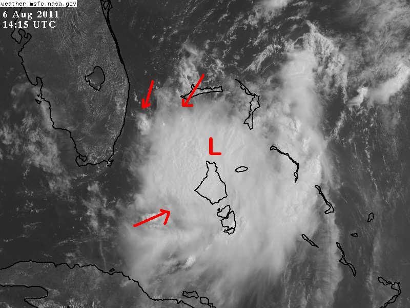
wind shift in the Bahamas, could be a very small LLC or just a trough ... in my opinion
0 likes   

User avatar
KWT
Category 5
Category 5
Posts: 31415
Joined: Tue Aug 17, 2004 11:02 am
Location: UK!!!

#8262 Postby KWT » Sat Aug 06, 2011 9:44 am

I suspect it maybe a poorly defined LLC there Hurakan judging from the Vis.loops, recon will tell the story when they fly in a little later.
0 likes   
Personal Forecast Disclaimer:
The posts in this forum are NOT official forecast and should not be used as such. They are just the opinion of the poster and may or may not be backed by sound meteorological data. They are NOT endorsed by any professional institution or storm2k.org. For official information, please refer to the NHC and NWS products

cpdaman
Category 5
Category 5
Posts: 3131
Joined: Sat Jun 10, 2006 11:44 am
Location: SPB county (gulf stream)

Re: ATL: EMILY - Remnants - Discussion

#8263 Postby cpdaman » Sat Aug 06, 2011 9:45 am

we need some low level convergence to go BOOM

one can be excused for looking at this loop and saying ...."oh boy" something is hatching in our backyard

http://aviationweather.gov/adds/satelli ... &itype=vis
0 likes   

Aric Dunn
Category 5
Category 5
Posts: 21238
Age: 42
Joined: Sun Sep 19, 2004 9:58 pm
Location: Ready for the Chase.
Contact:

#8264 Postby Aric Dunn » Sat Aug 06, 2011 9:50 am

I mean its way more organized than yesterday. going to take just a little longer to develop a well defined LLC
0 likes   
Note: If I make a post that is brief. Please refer back to previous posts for the analysis or reasoning. I do not re-write/qoute what my initial post said each time.
If there is nothing before... then just ask :)

Space & Atmospheric Physicist, Embry-Riddle Aeronautical University,
I believe the sky is falling...

cpdaman
Category 5
Category 5
Posts: 3131
Joined: Sat Jun 10, 2006 11:44 am
Location: SPB county (gulf stream)

Re:

#8265 Postby cpdaman » Sat Aug 06, 2011 9:51 am

Aric Dunn wrote:I mean its way more organized than yesterday. going to take just a little longer to develop a well defined LLC


aric where do you think this thing will be located by about midnite tonite.....i mean looks to be moving VERY slow now....just wondering what your thoughts are on movement over next 12-18 hours

also at this time can you tell if this is /(would likely be) a relatively small (size wise system) Thank you for any reply. B/c as we know with small system's intensity forecasts are extremely sketchy once they are in good enviornment
0 likes   

User avatar
artist
Category 5
Category 5
Posts: 9792
Joined: Mon Jun 06, 2005 3:26 pm
Location: West Palm

#8266 Postby artist » Sat Aug 06, 2011 9:53 am

Nassau International Airport obs -
http://www.wrh.noaa.gov/zoa/getobext.ph ... banner=off

pressure is rather high at 1015
winds out of the SW @ 12
0 likes   

Aric Dunn
Category 5
Category 5
Posts: 21238
Age: 42
Joined: Sun Sep 19, 2004 9:58 pm
Location: Ready for the Chase.
Contact:

Re: Re:

#8267 Postby Aric Dunn » Sat Aug 06, 2011 9:54 am

cpdaman wrote:
Aric Dunn wrote:I mean its way more organized than yesterday. going to take just a little longer to develop a well defined LLC


aric where do you think this thing will be located by about midnite tonite.....i mean looks to be moving VERY slow now....just wondering what your thoughts are on movement over next 12-18 hours

also at this time can you tell if this is a relatively small (size wise system) Thank you for any reply. B/c as we know with small system's intensity forecasts are extremely sketchy once they are in good enviornment


well everything suggest NNW to N for the next 12 hours or so.. but right now its more NW... I think it might make it a little farther west before lifting out..
yeah its definitely a small system
Last edited by Aric Dunn on Sat Aug 06, 2011 9:55 am, edited 1 time in total.
0 likes   
Note: If I make a post that is brief. Please refer back to previous posts for the analysis or reasoning. I do not re-write/qoute what my initial post said each time.
If there is nothing before... then just ask :)

Space & Atmospheric Physicist, Embry-Riddle Aeronautical University,
I believe the sky is falling...

crimi481
Category 2
Category 2
Posts: 602
Joined: Thu Sep 09, 2004 4:47 pm

Re: ATL: EMILY - Remnants - Discussion

#8268 Postby crimi481 » Sat Aug 06, 2011 9:54 am

Miami long range radar - seems to indicate a slow west (even slightly south of west) moement.
Not sure if there is anything strong enough to pull system north.?
http://radar.weather.gov/radar.php?rid= ... 1&loop=yes

May sit close to Fl E. Coast -and grow bigger?
0 likes   

User avatar
NDG
S2K Supporter
S2K Supporter
Posts: 15446
Joined: Sun Jul 09, 2006 10:14 pm
Location: Orlando, FL

#8269 Postby NDG » Sat Aug 06, 2011 9:55 am

This is where I put the approximate location of the suspect LLC developing, in the last frames of the vis loop you can clearly see an inflow of low clouds from the SW.
And NE winds east of Miami in the northern Bahamas, confirmed by surface reports.
I give it a greater than 50% that the recon will find a closed circulation, question is if they will find strong enough winds, if convection still around, they might. As MIA radar vilocity shows 30-35 knots in the area of convection.

Image
0 likes   

User avatar
wxman57
Moderator-Pro Met
Moderator-Pro Met
Posts: 22978
Age: 67
Joined: Sat Jun 21, 2003 8:06 pm
Location: Houston, TX (southwest)

Re: ATL: EMILY - Remnants - Discussion

#8270 Postby wxman57 » Sat Aug 06, 2011 9:57 am

By midnight tonight it should be about 150 miles east of Cape Canaveral (a bit north of 28N) and turning NE - heading out to sea.
0 likes   

Kory
Tropical Storm
Tropical Storm
Posts: 200
Age: 29
Joined: Tue Aug 02, 2011 11:32 am
Location: New Orleans, Louisiana

#8271 Postby Kory » Sat Aug 06, 2011 9:57 am

The remnants of Emily are very slowly drifting to the NW it appears. If this gets close to the coast, some of the bands could produce flooding rain. She is coming back to life.


The posts in this forum are NOT official forecast and should not be used as such. They are just the opinion of the poster and may or may not be backed by sound meteorological data. They are NOT endorsed by any professional institution or storm2k.org. For official information, please refer to the NHC and NWS products.
Last edited by Kory on Sat Aug 06, 2011 9:59 am, edited 1 time in total.
0 likes   

User avatar
mutley
S2K Supporter
S2K Supporter
Posts: 311
Joined: Wed Aug 15, 2007 7:18 am
Location: Gainesville, FL

Re: ATL: EMILY - Remnants - Discussion

#8272 Postby mutley » Sat Aug 06, 2011 9:59 am

crimi481 wrote:Miami long range radar - seems to indicate a slow west (even slightly south of west) moement.
Not sure if there is anything strong enough to pull system north.?
http://radar.weather.gov/radar.php?rid= ... 1&loop=yes

May sit close to Fl E. Coast -and grow bigger?


It's definitely going nowhere fast, at the moment anyway. Thunderstorms are staying pretty consistent too. I think it's interesting enough to keep an eye on through the day. You never know with this girl.
0 likes   
The preceding comments are never to be used as information to establish circumstances, plans or procedures for any weather related events. Only use official National Hurricane Center or National Weather Service information issued for your area.

cpdaman
Category 5
Category 5
Posts: 3131
Joined: Sat Jun 10, 2006 11:44 am
Location: SPB county (gulf stream)

Re: ATL: EMILY - Remnants - Discussion

#8273 Postby cpdaman » Sat Aug 06, 2011 10:00 am

thank you
0 likes   

Kory
Tropical Storm
Tropical Storm
Posts: 200
Age: 29
Joined: Tue Aug 02, 2011 11:32 am
Location: New Orleans, Louisiana

#8274 Postby Kory » Sat Aug 06, 2011 10:01 am

The only thing that may inhibit her from developing again the some shear coming in on the north and east side and some dry air to her southwest which in time may get ingested.

The posts in this forum are NOT official forecast and should not be used as such. They are just the opinion of the poster and may or may not be backed by sound meteorological data. They are NOT endorsed by any professional institution or storm2k.org. For official information, please refer to the NHC and NWS products.
0 likes   

User avatar
x-y-no
Category 5
Category 5
Posts: 8359
Age: 65
Joined: Wed Aug 11, 2004 12:14 pm
Location: Fort Lauderdale, FL

#8275 Postby x-y-no » Sat Aug 06, 2011 10:03 am

Dead calm at Ft. Lauderdale beach all morning. Outflow cirrus shield is not quite overhead yet, but getting close ... getting some towering cumulus blooming over the Gulf Stream to the SE.
0 likes   

User avatar
artist
Category 5
Category 5
Posts: 9792
Joined: Mon Jun 06, 2005 3:26 pm
Location: West Palm

#8276 Postby artist » Sat Aug 06, 2011 10:03 am

Bimini Islands have a calm wind which is located just a tad northwest of Andros Island. 29.97 Pressure
0 likes   

User avatar
artist
Category 5
Category 5
Posts: 9792
Joined: Mon Jun 06, 2005 3:26 pm
Location: West Palm

Re: ATL: EMILY - Remnants - Discussion

#8277 Postby artist » Sat Aug 06, 2011 10:07 am

here is a map -
Image

Freeport right now has winds out of the NNE and 29.95 pressure
0 likes   

Kory
Tropical Storm
Tropical Storm
Posts: 200
Age: 29
Joined: Tue Aug 02, 2011 11:32 am
Location: New Orleans, Louisiana

#8278 Postby Kory » Sat Aug 06, 2011 10:10 am

Some squalls are moving in from the northeast toward Ft. Lauderdale and Miami. Some gusty winds and brief heavy rainfall is possible with these storms.
0 likes   

User avatar
NDG
S2K Supporter
S2K Supporter
Posts: 15446
Joined: Sun Jul 09, 2006 10:14 pm
Location: Orlando, FL

Re:

#8279 Postby NDG » Sat Aug 06, 2011 10:12 am

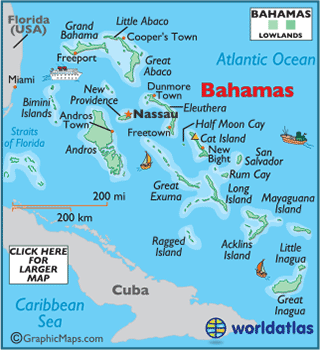
artist wrote:Bimini Islands have a calm wind which is located just a tad northwest of Andros Island. 29.97 Pressure


I see the only wx station through wunderground reporting NW to W winds all morning long, currently out of the west.

http://www.wunderground.com/weatherstation/WXDailyHistory.asp?ID=IBIMINIA2
0 likes   

Frank2
Category 5
Category 5
Posts: 4061
Joined: Mon Jul 25, 2005 12:47 pm

Re: ATL: EMILY - Remnants - Discussion

#8280 Postby Frank2 » Sat Aug 06, 2011 10:14 am

Weather here this morning is fine - light winds and multilayered clouds to the east...

MIA radar shows that one area of rain with embedded cells, but really nothing to get excited over...

True, on satellite it seems better organized - but that's not saying too much...

Frank
0 likes   


Return to “2011”

Who is online

Users browsing this forum: No registered users and 19 guests