ATL: EMILY - Remnants

Moderator: S2k Moderators

Message
Author
Shuriken

Re: ATL: EMILY - Tropical Storm - Discussion

#6041 Postby Shuriken » Wed Aug 03, 2011 12:57 pm

psyclone wrote:this system has consistently looked like garbage from go. it's basically a blob of heavy rain which is a threat in orographic enhancement zones. other than that, it's never been much to look at.
An "old hand" who takes a single glance at the following pic of a WNW-tracking storm in the "high season" immediately thinks Cat-4 in the Gulf of Mexico.

Remember Gustav and Charlie. Gustav looked worse than this.

Image
0 likes   

User avatar
wzrgirl1
S2K Supporter
S2K Supporter
Posts: 1326
Joined: Sat Sep 04, 2004 6:44 am
Location: Pembroke Pines, Florida

Re: ATL: EMILY - Tropical Storm - Discussion

#6042 Postby wzrgirl1 » Wed Aug 03, 2011 12:58 pm

mf_dolphin wrote:
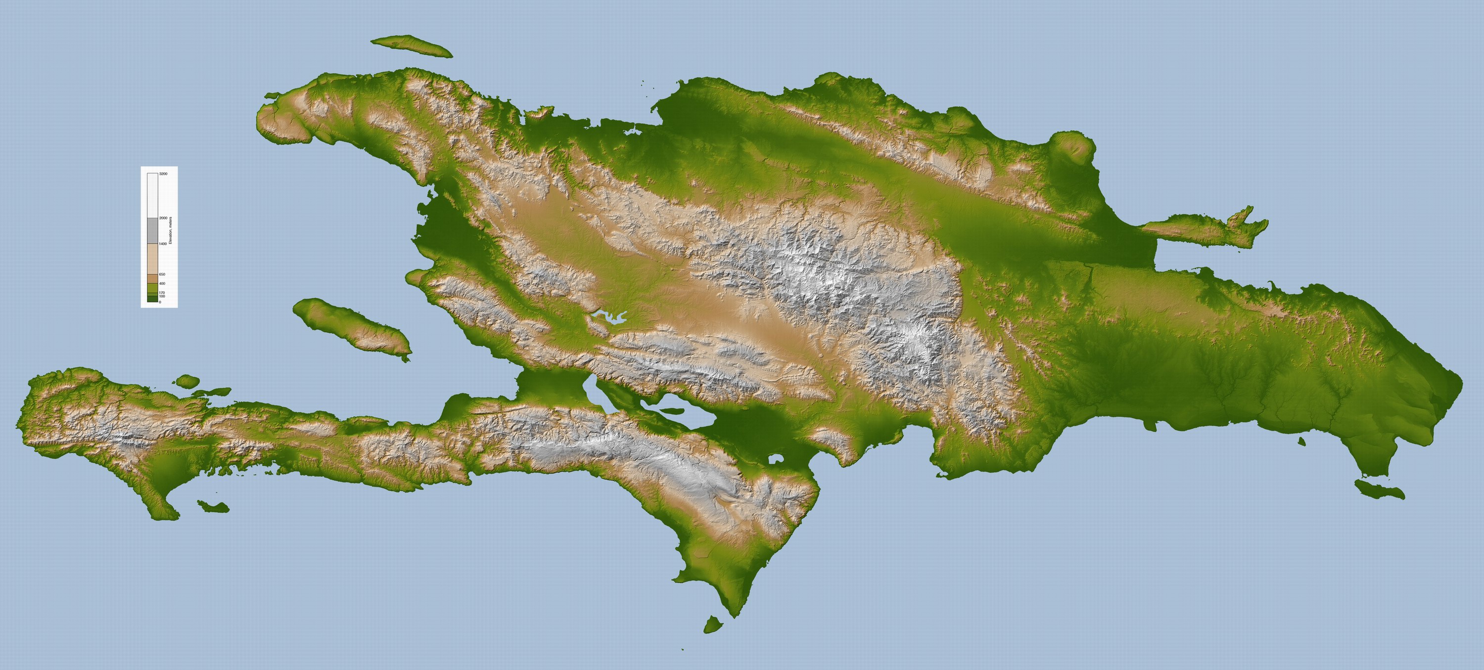
wzrgirl1 wrote:Can someone repost the map of Haiti and Hispanoila with the Terrain? I can't seem to locate it. Thanks!


Image

Here you go :-)


Gracias mi amor!!
0 likes   

Frank2
Category 5
Category 5
Posts: 4061
Joined: Mon Jul 25, 2005 12:47 pm

#6043 Postby Frank2 » Wed Aug 03, 2011 12:59 pm

Thats the best forecast I heard all day. lol


Don't forget our friend NOLA...

Too true - just a word of advice, folks - that's why it's not worth losing sleep over questionable systems, because all you end up with is feeling tired...
Last edited by Frank2 on Wed Aug 03, 2011 1:00 pm, edited 1 time in total.
0 likes   

5KOVERLIBOR

Re: ATL: EMILY - Tropical Storm - Discussion

#6044 Postby 5KOVERLIBOR » Wed Aug 03, 2011 12:59 pm

Shuriken wrote:
psyclone wrote:this system has consistently looked like garbage from go. it's basically a blob of heavy rain which is a threat in orographic enhancement zones. other than that, it's never been much to look at.
An "old hand" who takes a single glance at the following pic of a WNW-tracking storm in the "high season" immediately thinks Cat-4 in the Gulf of Mexico.

Remember Gustav and Charlie. Gustav looked worse than this.


This requires you to draw statistical analogies to conditions that existed with those events. Can you do that?
0 likes   

jonj2040
Tropical Storm
Tropical Storm
Posts: 227
Age: 30
Joined: Sat Jul 10, 2010 10:00 pm
Location: Palm Bay, FL

#6045 Postby jonj2040 » Wed Aug 03, 2011 1:00 pm

000
URNT15 KNHC 031750
AF306 0805A EMILY HDOB 09 20110803
174030 1754N 06913W 7641 02406 0101 +129 +034 115024 025 /// /// 03
174100 1755N 06912W 7897 02135 0118 +135 +041 135025 028 /// /// 03
174130 1756N 06910W 8157 01858 0125 +137 +047 150030 032 /// /// 03
174200 1758N 06909W 8408 01599 0121 +152 +054 154031 033 /// /// 03
174230 1759N 06908W 8440 01564 0123 +155 +059 151030 031 /// /// 03
174300 1758N 06906W 8427 01587 0127 +154 +064 150028 029 /// /// 03
174330 1757N 06908W 8439 01569 0122 +151 +068 152033 035 /// /// 03
174400 1756N 06909W 8433 01573 0118 +155 +069 150036 037 /// /// 03
174430 1755N 06910W 8438 01570 0116 +160 +071 149035 036 /// /// 03
174500 1754N 06911W 8435 01574 0116 +160 +072 144037 038 /// /// 03
174530 1753N 06912W 8436 01571 0116 +160 +073 143038 038 /// /// 03
174600 1752N 06913W 8436 01569 0112 +161 +074 139037 037 /// /// 03
174630 1751N 06915W 8434 01568 0111 +165 +076 138036 036 037 000 03
174700 1750N 06916W 8436 01566 0111 +165 +077 141036 037 037 001 00
174730 1748N 06917W 8436 01567 0107 +167 +078 141033 036 036 000 00
174800 1747N 06918W 8432 01572 0105 +170 +079 140030 031 034 000 00
174830 1746N 06919W 8436 01565 0104 +170 +080 142029 030 035 000 00
174900 1745N 06920W 8434 01567 0100 +174 +081 143031 032 035 000 00
174930 1744N 06922W 8440 01561 0096 +183 +081 144030 031 041 000 00
175000 1743N 06923W 8432 01569 0096 +181 +082 144032 033 040 000 03
$$
;
0 likes   
I am just an amateur and a "noob" at that so any speculations that I have made are just that, uneducated speculations. Please refer to the NHC for accurate information.
Thank you all for your thoughts, I've loved reading through this community since '06 and finally decided to post more actively.
-JJ :D

jonj2040
Tropical Storm
Tropical Storm
Posts: 227
Age: 30
Joined: Sat Jul 10, 2010 10:00 pm
Location: Palm Bay, FL

#6046 Postby jonj2040 » Wed Aug 03, 2011 1:00 pm

Image

Uploaded with ImageShack.us
0 likes   
I am just an amateur and a "noob" at that so any speculations that I have made are just that, uneducated speculations. Please refer to the NHC for accurate information.
Thank you all for your thoughts, I've loved reading through this community since '06 and finally decided to post more actively.
-JJ :D

User avatar
gatorcane
S2K Supporter
S2K Supporter
Posts: 23692
Age: 47
Joined: Sun Mar 13, 2005 3:54 pm
Location: Boca Raton, FL

#6047 Postby gatorcane » Wed Aug 03, 2011 1:01 pm

Structure doesn't look that bad actually and convection is building back now near the LLC. If she manages to avoid alot of land (which looks like it could be the case now), upper-level conditions are only going to improve over the next couple of days especially north of Cuba as a large upper-level anticyclone is in the process of building east of Florida

Certainly looks like the NHC track is going to need another slight westward adjustment at 5pm as she is already tracking left of the forecast point.
Last edited by gatorcane on Wed Aug 03, 2011 1:03 pm, edited 2 times in total.
0 likes   

jonj2040
Tropical Storm
Tropical Storm
Posts: 227
Age: 30
Joined: Sat Jul 10, 2010 10:00 pm
Location: Palm Bay, FL

#6048 Postby jonj2040 » Wed Aug 03, 2011 1:02 pm

000
URNT15 KNHC 031800
AF306 0805A EMILY HDOB 10 20110803
175030 1742N 06924W 8435 01564 0094 +183 +083 144036 038 038 000 00
175100 1740N 06925W 8434 01564 0093 +184 +083 141039 041 035 000 00
175130 1739N 06926W 8435 01561 0092 +185 +084 137039 040 036 000 00
175200 1738N 06927W 8428 01568 0090 +187 +083 134037 039 034 000 03
175230 1737N 06929W 8437 01560 0089 +188 +084 134040 041 036 000 00
175300 1736N 06930W 8436 01560 0091 +184 +084 133039 040 035 000 00
175330 1735N 06931W 8439 01556 0086 +190 +083 128036 041 037 001 00
175400 1733N 06932W 8437 01561 0088 +189 +083 125035 037 039 000 00
175430 1732N 06933W 8436 01561 0086 +190 +083 123033 035 038 004 00
175500 1731N 06935W 8436 01562 0086 +187 +083 120034 035 038 003 00
175530 1730N 06936W 8436 01558 0090 +182 +082 121033 035 039 001 00
175600 1729N 06937W 8437 01558 0107 +152 +081 125034 034 041 009 00
175630 1727N 06938W 8426 01567 0103 +160 +076 118036 036 040 007 03
175700 1726N 06940W 8440 01556 0096 +172 +072 118033 033 038 004 00
175730 1725N 06941W 8435 01558 0106 +153 +073 115034 034 040 002 00
175800 1724N 06942W 8429 01563 0109 +145 +074 118035 037 042 009 00
175830 1722N 06943W 8442 01550 0100 +157 +074 120034 036 039 002 00
175900 1721N 06945W 8428 01561 0101 +153 +074 113030 033 041 006 00
175930 1720N 06946W 8436 01552 0098 +158 +074 114028 030 043 006 00
180000 1719N 06947W 8437 01552 0103 +149 +075 109026 028 044 008 00
$$
;
0 likes   
I am just an amateur and a "noob" at that so any speculations that I have made are just that, uneducated speculations. Please refer to the NHC for accurate information.
Thank you all for your thoughts, I've loved reading through this community since '06 and finally decided to post more actively.
-JJ :D

User avatar
mf_dolphin
Category 5
Category 5
Posts: 17758
Age: 68
Joined: Tue Oct 08, 2002 2:05 pm
Location: St Petersburg, FL
Contact:

Re: ATL: EMILY - Tropical Storm - Discussion

#6049 Postby mf_dolphin » Wed Aug 03, 2011 1:03 pm

micktooth wrote:Here's my prediction... Emily is quite a mess, since it's the only game in town, everyone is analyzing the heck out of her. But I can predict a few things:
1. As the naked swirl moves farther west, we'll hear from more Florida posters about the potential impact to the Sunshine State.
2. My 24 hour prediction if the Emily swirl continues west...more Louisiana and Texas posters warning of a western GOMEX "strike."
3. Continued comparisons of this swirl to catastrophic storms ...

You never know what will happen in the tropics, but the posts in the Storm 2K forums are quite predictable :wink:

The above post is NOT an official forecast and should not be used as such. It is just the opinion of the poster and may or may not be backed by sound meteorological data. It is NOT endorsed by any professional institution including storm2k.org For Official Information please refer to the NHC and NWS products.


1. And your point is? As it moves more west. naked or not at this time, Florida residents should become more concerned. That's called being aware.
2. If, and I say if, it was to miss the weakness and get into the GOM or west Carib then it should get the attention of everyone along the gulf coast. Panic no, aware yes.
3. Every storm get's compared to memorable past storms.

Personally I didn't find your post amusing. We try to promote understanding and awareness and sarcasm doesn't lend itself to people asking questions. Only when they ask questions do they have an opportunity to be educated.
0 likes   

User avatar
SouthDadeFish
Professional-Met
Professional-Met
Posts: 2835
Joined: Thu Sep 23, 2010 2:54 pm
Location: Miami, FL
Contact:

Re:

#6050 Postby SouthDadeFish » Wed Aug 03, 2011 1:04 pm

gatorcane wrote:Structure doesn't look that bad actually and convection is building back now near the LLC. If she manages to avoid alot of land (which looks like it could be the case now), upper-level conditions are only going to improve over the next couple of days especially north of Cuba as a large upper-level anticyclone is in the process of building east of Florida

Certainly looks like the NHC track is going to need another slight westward adjustment at 5pm as she is already tracking left of the forecast point.


I agree. Although its sheared, this might be the best the lower-level structure has ever looked.
0 likes   

jonj2040
Tropical Storm
Tropical Storm
Posts: 227
Age: 30
Joined: Sat Jul 10, 2010 10:00 pm
Location: Palm Bay, FL

#6051 Postby jonj2040 » Wed Aug 03, 2011 1:04 pm

Image

Uploaded with ImageShack.us
0 likes   
I am just an amateur and a "noob" at that so any speculations that I have made are just that, uneducated speculations. Please refer to the NHC for accurate information.
Thank you all for your thoughts, I've loved reading through this community since '06 and finally decided to post more actively.
-JJ :D

hurr123
Tropical Low
Tropical Low
Posts: 13
Joined: Sun Jul 31, 2011 6:54 pm

Re: ATL: EMILY - Tropical Storm - Discussion

#6052 Postby hurr123 » Wed Aug 03, 2011 1:06 pm

Does anyone know if JB has commented on Emily...I am interested in his thoughts and comments on strength and course he thinks this system may take.
0 likes   

lebron23
Category 1
Category 1
Posts: 389
Age: 32
Joined: Sat May 24, 2008 11:58 am
Contact:

Re: ATL: EMILY - Tropical Storm - Discussion

#6053 Postby lebron23 » Wed Aug 03, 2011 1:06 pm

What are the local tv stations saying about this in Florida?
0 likes   

Frank2
Category 5
Category 5
Posts: 4061
Joined: Mon Jul 25, 2005 12:47 pm

#6054 Postby Frank2 » Wed Aug 03, 2011 1:08 pm

What are the local tv stations saying about this in Florida?


Right now they are probably having a creative meeting to figure out how to explain at 5 p.m. that the system isn't doing what they said it would do...

LOL

This happened during my time at the NHC and they'd get frustrated and try their best to cover the unexpected good turn of events, explaining that unexpected good news is always better than a hurricane warning...
Last edited by Frank2 on Wed Aug 03, 2011 1:10 pm, edited 1 time in total.
0 likes   

User avatar
dizzyfish
S2K Supporter
S2K Supporter
Posts: 1519
Joined: Fri Sep 16, 2005 7:56 am
Location: New Port Richey, FL

Re: ATL: EMILY - Tropical Storm - Discussion

#6055 Postby dizzyfish » Wed Aug 03, 2011 1:09 pm

lebron23 wrote:What are the local tv stations saying about this in Florida?


Last I heard (early this morning) was to keep an eye on it.
0 likes   

User avatar
gatorcane
S2K Supporter
S2K Supporter
Posts: 23692
Age: 47
Joined: Sun Mar 13, 2005 3:54 pm
Location: Boca Raton, FL

#6056 Postby gatorcane » Wed Aug 03, 2011 1:09 pm

Looking at the models graphic above, what looks to be happening is that you have models splitting into two camps. In the one camp, they send a remnant circulation or very weak, shallow system through Cuba and through the FL Straits into the GOM.

In the other camp, the models keep the system vertically stacked enough so that it feels the weakness, turns north and then eventually northeast through the Bahamas east of Florida.
0 likes   

Shuriken

Re: ATL: EMILY - Tropical Storm - Discussion

#6057 Postby Shuriken » Wed Aug 03, 2011 1:09 pm

5KOVERLIBOR wrote:
Shuriken wrote:
psyclone wrote:this system has consistently looked like garbage from go. it's basically a blob of heavy rain which is a threat in orographic enhancement zones. other than that, it's never been much to look at.
An "old hand" who takes a single glance at the following pic of a WNW-tracking storm in the "high season" immediately thinks Cat-4 in the Gulf of Mexico.

Remember Gustav and Charlie. Gustav looked worse than this.

http://img32.imageshack.us/img32/2613/fffhf.png
This requires you to draw statistical analogies to conditions that existed with those events.
"Statistically, my eyeballs have seen this exact same scenario many times before. Now, do you want to pay attention to me, you young whippersnapper, or do you want to continue discarding the wisdom of your elders -- as is fashionable among the youth of today?"

<jam corncob pipe back in mouth; resume rocking on porch chair>
0 likes   

User avatar
NDG
S2K Supporter
S2K Supporter
Posts: 15456
Joined: Sun Jul 09, 2006 10:14 pm
Location: Orlando, FL

#6058 Postby NDG » Wed Aug 03, 2011 1:09 pm

Recon finds winds still close to 50 mph, there's no way she's a TD.
0 likes   

User avatar
Blown Away
S2K Supporter
S2K Supporter
Posts: 10162
Joined: Wed May 26, 2004 6:17 am

Re: ATL: EMILY - Tropical Storm - Discussion

#6059 Postby Blown Away » Wed Aug 03, 2011 1:10 pm

Miami Storm Tracker wrote:
Blown Away wrote:The current track trajectory keeps Emily over the least amount of land: Haiti Tiburon Peninsula - Golf of Gonave - E tip of Cuba. If Emily's LLC survives the next 36 hours, Emily could take a nice ride over very warm SST's and improving upper level conditions. Once N of Cuba Emily will have almost 2 days before reaching the closest point to Florida, about 70 miles E of WPB. Much can happen in 2 days over warm water and low shear! IMO, NHC is conservative with intensity expecting more land interaction, but IMO Emily is moving under Hispaniola not over the heart of the island.


Blown Away,

Are you saying WPB because of the direction it will be moving, because you do have the Keys and S.FLA before WPB. Just wondering


Based on the 11am track the closest point Emily will get to Florida will be E of WPB @70 miles and assuming the track stays the same it will take almost 2 days from N Cuba to E of WPB. Pointing out that 48 hours over very warm SST's and low shear can be plenty of time for a system to significantly strengthen, many examples. That's it. :D
0 likes   
Hurricane Eye Experience: David 79, Irene 99, Frances 04, Jeanne 04, Wilma 05… Hurricane Brush Experience: Andrew 92, Erin 95, Floyd 99, Matthew 16, Irma 17, Ian 22, Nicole 22…

5KOVERLIBOR

Re: ATL: EMILY - Tropical Storm - Discussion

#6060 Postby 5KOVERLIBOR » Wed Aug 03, 2011 1:11 pm

Shuriken wrote:"Statistically, my eyeballs have seen this exact same scenario many times before. Now, do you want to pay attention to me, you young whippersnapper, or do you want to continue discarding the wisdom of your elders -- as is fashionable among the youth of today?"

<jam corncob pipe back in mouth; resume rocking on porch chair>


Very helpful - thank you. I look forward to your continued capricious conjecture.
Last edited by 5KOVERLIBOR on Wed Aug 03, 2011 1:12 pm, edited 1 time in total.
0 likes   


Return to “2011”

Who is online

Users browsing this forum: No registered users and 17 guests