ATL: EMILY - Remnants
Moderator: S2k Moderators
-
wzrgirl1

- S2K Supporter

- Posts: 1360
- Joined: Sat Sep 04, 2004 6:44 am
- Location: Pembroke Pines, Florida
Re: ATL: EMILY - Tropical Storm - Discussion
There is something to be said of persistence, and I do believe Emily has this. Don't count her out quite yet. This may be a good time for some of you to take a break, take a nap, or something and come back in a few hours. Not much will change until she makes that turn and reemerges. I know, I get it, I am caught up in it as well, but sometimes this things will drive you mad!!!
0 likes
-
Shuriken
Re: ATL: EMILY - Tropical Storm - Discussion
Is that why they constantly undershoot intensity forecasts of Caribbean hurricanes that underwent a decoupling in the eastern Caribbean?Frank2 wrote:the old NHC thinking was that once the LLC becomes exposed, the chance of it regaining it's former status was fairly low
Any swirl which makes it intact into the sweet spot southwest of Cuba has a good chance of blowing up to cat-4 in no time flat.
0 likes
-
Blown Away

- S2K Supporter
- Posts: 10253
- Joined: Wed May 26, 2004 6:17 am
Re: ATL: EMILY - Tropical Storm - Discussion
The current track trajectory keeps Emily over the least amount of land: Haiti Tiburon Peninsula - Golf of Gonave - E tip of Cuba. If Emily's LLC survives the next 36 hours, Emily could take a nice ride over very warm SST's and improving upper level conditions. Once N of Cuba Emily will have almost 2 days before reaching the closest point to Florida, about 70 miles E of WPB. Much can happen in 2 days over warm water and low shear! IMO, NHC is conservative with intensity expecting more land interaction, but IMO Emily is moving under Hispaniola not over the heart of the island.
0 likes
Hurricane Eye Experience: David 79, Irene 99, Frances 04, Jeanne 04, Wilma 05… Hurricane Brush Experience: Andrew 92, Erin 95, Floyd 99, Matthew 16, Irma 17, Ian 22, Nicole 22…
Re: ATL: EMILY - Tropical Storm - Discussion
Frank2 wrote:Late yesterday morning it looked to be forming an eye, and now it has an exposed LLC with convection mostly far removed from the center - the old NHC thinking was that once the LLC becomes exposed, the chance of it regaining it's former status was fairly low...
It might not make much sense but in reality it does seem true and has happened many times over the years, for reasons not fully understood...
Frank
somehow i don't recall the attempt to form an eye. this system has consistently looked like garbage from go. it's basically a blob of heavy rain which is a threat in orographic enhancement zones. other than that, it's never been much to look at.
0 likes
-
Shuriken
Re: ATL: EMILY - Tropical Storm - Discussion
Quick recurve scenarios depend upon a coupled vertical system; take that away, and the LLC scoots stubbornly WNW left of forecast.
0 likes
Re: ATL: EMILY - Recon Discussion
What is with the little turn?
Code: Select all
As of the last observation at 17:40:00Z, the plane's...

Direction of Travel: NE (44°)
Location: 59 miles (95 km) to the SE (134°) from Santo Domingo, Dominican Republic.
0 likes
-
cycloneye

- Admin

- Posts: 149019
- Age: 69
- Joined: Thu Oct 10, 2002 10:54 am
- Location: San Juan, Puerto Rico
Re: ATL: EMILY - Advisories
BULLETIN
TROPICAL STORM EMILY INTERMEDIATE ADVISORY NUMBER 8A
NWS NATIONAL HURRICANE CENTER MIAMI FL AL052011
200 PM EDT WED AUG 03 2011
...EMILY STILL MOVING WESTWARD...APPEARS TO BE LESS ORGANIZED.....
SUMMARY OF 200 PM EDT...1800 UTC...INFORMATION
----------------------------------------------
LOCATION...16.8N 70.3W
ABOUT 120 MI...190 KM SSW OF SANTO DOMINGO DOMINICAN REPUBLIC
MAXIMUM SUSTAINED WINDS...50 MPH...85 KM/H
PRESENT MOVEMENT...W OR 280 DEGREES AT 14 MPH...22 KM/H
MINIMUM CENTRAL PRESSURE...1006 MB...29.71 INCHES
WATCHES AND WARNINGS
--------------------
NONE
SUMMARY OF WATCHES AND WARNINGS IN EFFECT...
A TROPICAL STORM WARNING IS IN EFFECT FOR...
* THE DOMINICAN REPUBLIC
* HAITI
* SOUTHEASTERN BAHAMAS AND TURKS AND CAICOS ISLANDS
* GUANTANAMO AND HOLGUIN PROVINCES IN EASTERN CUBA
A TROPICAL STORM WATCH IS IN EFFECT FOR...
* CENTRAL BAHAMAS
FOR STORM INFORMATION SPECIFIC TO YOUR AREA IN THE UNITED
STATES...PLEASE MONITOR PRODUCTS ISSUED BY YOUR LOCAL NATIONAL
WEATHER SERVICE FORECAST OFFICE. FOR STORM INFORMATION SPECIFIC TO
YOUR AREA OUTSIDE THE UNITED STATES...PLEASE MONITOR PRODUCTS
ISSUED BY YOUR NATIONAL METEOROLOGICAL SERVICE.
DISCUSSION AND 48-HOUR OUTLOOK
------------------------------
AT 200 PM EDT...1800 UTC...THE CENTER OF TROPICAL STORM EMILY WAS
LOCATED NEAR LATITUDE 16.8 NORTH...LONGITUDE 70.3 WEST. EMILY IS
MOVING TOWARD THE WEST NEAR 14 MPH...22 KM/H. A TURN TO THE
NORTHWEST IS EXPECTED LATER TODAY. ON THE FORECAST TRACK...THE
CENTER OF EMILY WILL MOVE VERY NEAR OR OVER CABO BEATA IN THE
DOMINICAN REPUBLIC LATE TODAY...OVER HAITI TONIGHT...AND INTO THE
SOUTHEASTERN BAHAMAS AND TURKS AND CAICOS ISLANDS ON THURSDAY.
MAXIMUM SUSTAINED WINDS REMAIN NEAR 50 MPH...85 KM/H...WITH HIGHER
GUSTS. A RECONNAISSANCE AIRCRAFT IS CURRENTLY APPROACHING EMILY AND
WILL GIVE A BETTER ESTIMATE OF THE INTENSITY. LITTLE CHANGE IN
STRENGTH IS FORECAST TODAY BEFORE THE CENTER REACHES THE WESTERN
PORTION OF HISPANIOLA...FOLLOWED BY WEAKENING AS THE CENTER MOVES
OVER THE HIGH TERRAIN. SOME RE-STRENGTHENING IS POSSIBLE AFTER THE
CENTER MOVES AWAY FROM HISPANIOLA.
TROPICAL STORM FORCE WINDS EXTEND OUTWARD UP TO 115 MILES...185 KM
TO THE NORTH AND EAST OF THE THE CENTER.
ESTIMATED MINIMUM CENTRAL PRESSURE IS 1006 MB...29.71 INCHES.
HAZARDS AFFECTING LAND
----------------------
WIND...TROPICAL STORM CONDITIONS SHOULD NOW BE SPREADING OVER
PORTIONS OF THE DOMINICAN REPUBLIC...PRIMARILY ON THE SOUTHERN
COAST...AND WILL LIKELY SPREAD OVER HAITI LATER TODAY AND TONIGHT.
TROPICAL STORM CONDITIONS ARE EXPECTED TO REACH EXTREME EASTERN
CUBA...THE SOUTHEASTERN BAHAMAS AND THE TURKS AND CAICOS ISLANDS ON
THURSDAY. TROPICAL STORM CONDITIONS ARE POSSIBLE IN THE CENTRAL
BAHAMAS THURSDAY NIGHT.
RAINFALL...EMILY IS EXPECTED TO PRODUCE TOTAL RAIN ACCUMULATIONS
OF 6 TO 10 INCHES IN PUERTO RICO WITH ISOLATED AMOUNTS OF 12 INCHES.
RAINFALL ACCUMULATIONS OF 6 TO 12 INCHES WITH ISOLATED AMOUNTS OF 20
INCHES ARE POSSIBLE OVER THE DOMINICAN REPUBLIC AND HAITI. THESE
RAINS COULD CAUSE LIFE-THREATENING FLASH FLOODS AND MUD SLIDES.
TOTAL RAIN ACCUMULATIONS OF 2 TO 4 INCHES ARE EXPECTED IN THE
SOUTHEASTERN BAHAMAS AND TURKS AND CAICOS.
STORM SURGE...A STORM SURGE WILL RAISE WATER LEVELS BY 1 TO 2 FEET
ABOVE NORMAL TIDE LEVELS IN THE TROPICAL STORM WARNING AREA. NEAR
THE COAST...THE SURGE WILL BE ACCOMPANIED BY LARGE AND DANGEROUS
WAVES.
NEXT ADVISORY
-------------
NEXT COMPLETE ADVISORY...500 PM AST.
$$
FORECASTER AVILA
0 likes
Visit the Caribbean-Central America Weather Thread where you can find at first post web cams,radars
and observations from Caribbean basin members Click Here
and observations from Caribbean basin members Click Here

Re: ATL: EMILY - Tropical Storm - Discussion
lol they need to adjust the forcast track west.
0 likes
-
Stormcenter
- S2K Supporter
- Posts: 6689
- Joined: Wed Sep 03, 2003 11:27 am
- Location: Houston, TX
Re: ATL: EMILY - Models
It does sound like an "out". I still think it will eventually turn per the NHC the key is when.
TreasureIslandFLGal wrote:underthwx wrote:THE LOW-LEVEL CENTER HAS CONTINUED TO MOVE TOWARD THE WEST OR 280
DEGREES AT 12 KNOTS. ASSUMING EMILY CAN MAINTAIN A VERTICALLY DEEP
CIRCULATION...THE CYCLONE SHOULD SOON TURN MORE TO THE NORTHWEST
AND EVENTUALLY TOWARD THE NORTH AROUND THE PERIPHERY OF THE
SUBTROPICAL RIDGE. ALTHOUGH THERE HAS NOT BEEN A SIGNIFICANT CHANGE
IN THE STEERING PATTERN SOME OF THE GUIDANCE HAS SHIFTED SLIGHTLY
WESTWARD...AND SO HAS THE OFFICIAL FORECAST. THE GFS REMAINS ALONG
THE EASTERN EDGE OF THE GUIDANCE ENVELOPE.
11:00NHC...........my question is........are the models having difficulty responding due to uncertainty of what the strength of the system will be down the road?
Here is their "out". It is not maintaining that deep vertical at all, so their path is going to bust.
0 likes
-
itsahurricane
- Tropical Wave

- Posts: 9
- Joined: Fri Jul 29, 2011 4:06 pm
Re: ATL: EMILY - Tropical Storm - Discussion
lebron23 wrote:lol they need to adjust the forcast track west.
Seriously.
0 likes
-
maxx9512
- Tropical Storm

- Posts: 114
- Age: 66
- Joined: Thu May 31, 2007 7:55 pm
- Location: Cape Coral, Fl.
Re: ATL: EMILY - Tropical Storm - Discussion
Convection looks to be roughly half way around the llc and continuing to wrap, so i believe it's
far from dead. Like it was said earlier if this was the start of a system I think we would be impressed. With the ups and downs of this system not sure I know what to think.
http://www.ssd.noaa.gov/goes/flt/t2/rgb-l.jpg
far from dead. Like it was said earlier if this was the start of a system I think we would be impressed. With the ups and downs of this system not sure I know what to think.
http://www.ssd.noaa.gov/goes/flt/t2/rgb-l.jpg
0 likes
Re: ATL: EMILY - Tropical Storm - Discussion
[quote="lebron23"]lol they need to adjust the forcast track west.[/quote]
I agree...it's looking more and more like it just might make it into the SE GOM and then trek across the Peninsula as opposed to riding up the East Coast of FL. IMO, Emily is going to give the Carolinas a scare before it's all said and done.
I agree...it's looking more and more like it just might make it into the SE GOM and then trek across the Peninsula as opposed to riding up the East Coast of FL. IMO, Emily is going to give the Carolinas a scare before it's all said and done.
0 likes

Re: ATL: EMILY - Tropical Storm - Discussion
itsahurricane wrote:lebron23 wrote:lol they need to adjust the forcast track west.
Seriously.
Emily seems to be stubbornly pressing on westward.
0 likes
The preceding comments are never to be used as information to establish circumstances, plans or procedures for any weather related events. Only use official National Hurricane Center or National Weather Service information issued for your area.
-
Hurricaneman

- Category 5

- Posts: 7404
- Age: 45
- Joined: Tue Aug 31, 2004 3:24 pm
- Location: central florida
Re: ATL: EMILY - Tropical Storm - Discussion
is it possible the shear is starting to let up a bit
0 likes
-
Ground_Zero_92

- S2K Supporter
- Posts: 292
- Joined: Thu Sep 04, 2003 11:23 am
- Location: South Hutchinson Island / Stuart, FL
2pm Advisory
000
WTNT35 KNHC 031746
TCPAT5
BULLETIN
TROPICAL STORM EMILY INTERMEDIATE ADVISORY NUMBER 8A
NWS NATIONAL HURRICANE CENTER MIAMI FL AL052011
200 PM EDT WED AUG 03 2011
...EMILY STILL MOVING WESTWARD...APPEARS TO BE LESS ORGANIZED.....
SUMMARY OF 200 PM EDT...1800 UTC...INFORMATION
----------------------------------------------
LOCATION...16.8N 70.3W
ABOUT 120 MI...190 KM SSW OF SANTO DOMINGO DOMINICAN REPUBLIC
MAXIMUM SUSTAINED WINDS...50 MPH...85 KM/H
PRESENT MOVEMENT...W OR 280 DEGREES AT 14 MPH...22 KM/H
MINIMUM CENTRAL PRESSURE...1006 MB...29.71 INCHES
0 likes
-
micktooth

- S2K Supporter
- Posts: 391
- Joined: Mon Jul 11, 2005 3:47 pm
- Location: PreK:New Orleans,PostK:Colorado
Re: ATL: EMILY - Tropical Storm - Discussion
Here's my prediction... Emily is quite a mess, since it's the only game in town, everyone is analyzing the heck out of her. But I can predict a few things:
1. As the naked swirl moves farther west, we'll hear from more Florida posters about the potential impact to the Sunshine State.
2. My 24 hour prediction if the Emily swirl continues west...more Louisiana and Texas posters warning of a western GOMEX "strike."
3. Continued comparisons of this swirl to catastrophic storms ...
You never know what will happen in the tropics, but the posts in the Storm 2K forums are quite predictable
The above post is NOT an official forecast and should not be used as such. It is just the opinion of the poster and may or may not be backed by sound meteorological data. It is NOT endorsed by any professional institution including storm2k.org For Official Information please refer to the NHC and NWS products.
0 likes
-
mf_dolphin

- Category 5
- Posts: 17758
- Age: 69
- Joined: Tue Oct 08, 2002 2:05 pm
- Location: St Petersburg, FL
- Contact:
Re: ATL: EMILY - Tropical Storm - Discussion
wzrgirl1 wrote:Can someone repost the map of Haiti and Hispanoila with the Terrain? I can't seem to locate it. Thanks!
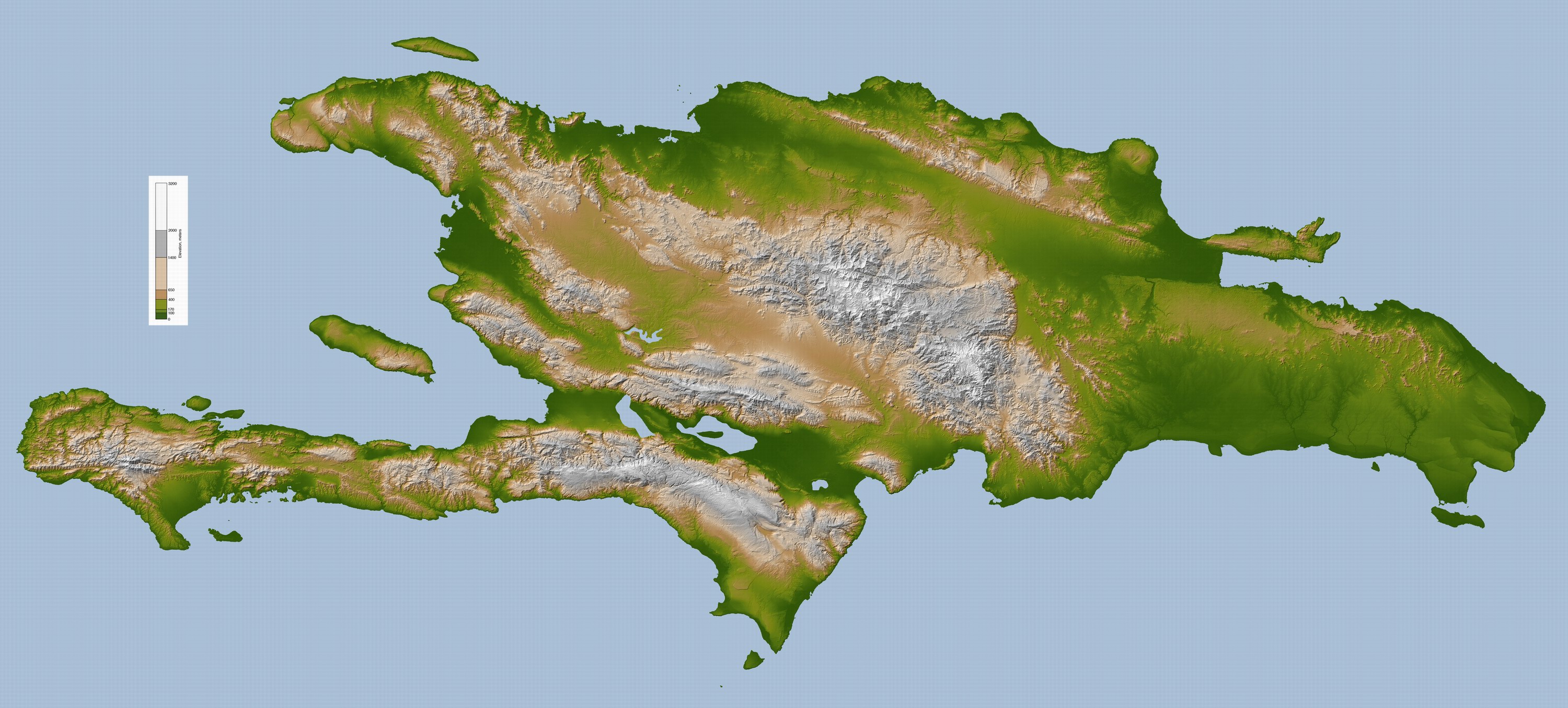
Here you go
0 likes
-
Miami Storm Tracker

- Category 4

- Posts: 916
- Age: 68
- Joined: Sun Jun 13, 2010 10:12 pm
- Location: Key Largo, Fla.
- Contact:
Re: ATL: EMILY - Tropical Storm - Discussion
Blown Away wrote:The current track trajectory keeps Emily over the least amount of land: Haiti Tiburon Peninsula - Golf of Gonave - E tip of Cuba. If Emily's LLC survives the next 36 hours, Emily could take a nice ride over very warm SST's and improving upper level conditions. Once N of Cuba Emily will have almost 2 days before reaching the closest point to Florida, about 70 miles E of WPB. Much can happen in 2 days over warm water and low shear! IMO, NHC is conservative with intensity expecting more land interaction, but IMO Emily is moving under Hispaniola not over the heart of the island.
Blown Away,
Are you saying WPB because of the direction it will be moving, because you do have the Keys and S.FLA before WPB. Just wondering
0 likes
-
Ground_Zero_92
- S2K Supporter
- Posts: 292
- Joined: Thu Sep 04, 2003 11:23 am
- Location: South Hutchinson Island / Stuart, FL
Re: ATL: EMILY - Tropical Storm - Discussion
micktooth wrote:Here's my prediction... Emily is quite a mess, since it's the only game in town, everyone is analyzing the heck out of her. But I can predict a few things:
1. As the naked swirl moves farther west, we'll hear from more Florida posters about the potential impact to the Sunshine State.
2. My 24 hour prediction if the Emily swirl continues west...more Louisiana and Texas posters warning of a western GOMEX "strike."
3. Continued comparisons of this swirl to catastrophic storms ...
You never know what will happen in the tropics, but the posts in the Storm 2K forums are quite predictable
The above post is NOT an official forecast and should not be used as such. It is just the opinion of the poster and may or may not be backed by sound meteorological data. It is NOT endorsed by any professional institution including storm2k.org For Official Information please refer to the NHC and NWS products.
Thats the best forecast I heard all day. lol
0 likes
Who is online
Users browsing this forum: No registered users and 42 guests