ATL: DON - Remnant - Discussion

Moderator: S2k Moderators

Message
Author
User avatar
nicole
Tropical Low
Tropical Low
Posts: 32
Age: 38
Joined: Tue Jul 19, 2011 10:49 am
Location: East Texas!

Re:

#1321 Postby nicole » Tue Jul 26, 2011 3:59 pm

gatorcane wrote:When are the models going to start picking up on this system?

What are they seeing that is not causing them to develop it?

Maybe it is a 2011 thing, but so far the models are having a tough time even detecting development on these smaller systems.


IMO...this has been an ALL AROUND unpredictable year for weather...snow,tornados,flooding,this god-awful HEAT and drought! I completely expect this to be an exciting and unpredictable summer for hurricanes also! Things are so nuts with the weather that its probably confusing the models...or something like that.. 8-)
0 likes   

User avatar
TheDreamTraveler
Category 2
Category 2
Posts: 641
Joined: Sun Aug 22, 2010 3:10 am
Location: PA

Re: ATL: INVEST 90L - Discussion

#1322 Postby TheDreamTraveler » Tue Jul 26, 2011 3:59 pm

Given the conditions, the storm should reach minimal hurricane strength by the time it reaches the Gulf coast. I don't expect it to get any stronger than that unless it goes through a period of rapid intensification, which isn't out of the question given how horrible computer models are with predicting intensity. Though my observations are just opinion.

I'm really hoping that the storm makes a pass at Texas, not to wishcast obviously, but because of the drought they've been enduring. I've been looking at it a lot, and all they need is a tropical storm or hurricane to help repair some of the moisture they've lost. So I'll be hoping for all of you.
Last edited by TheDreamTraveler on Tue Jul 26, 2011 4:05 pm, edited 1 time in total.
0 likes   

User avatar
wxman57
Moderator-Pro Met
Moderator-Pro Met
Posts: 22980
Age: 67
Joined: Sat Jun 21, 2003 8:06 pm
Location: Houston, TX (southwest)

Re: ATL: INVEST 90L - Models

#1323 Postby wxman57 » Tue Jul 26, 2011 4:00 pm


We know where it's NOT going, then.
0 likes   

User avatar
RachelAnna
Tropical Storm
Tropical Storm
Posts: 106
Joined: Mon Jun 28, 2010 10:38 pm
Location: Cypress, Texas

Re: ATL: INVEST 90L - Models

#1324 Postby RachelAnna » Tue Jul 26, 2011 4:01 pm

Outlaw JW wrote:
RachelAnna wrote:Models are giving me some hope that *maybe* we can at least get a bit of rain here--don't need a TS or a hurricane, but good soaking rains would be awesome. Got a nice downpour yesterday, but I think it just made my lawn thirstier! C'mon 90L, at least be a rainmaker for most of Texas!


Our cattle and wildlife are dying out here, our lawns are long since dead.

http://www.woai.com/content/news/beamer/story/Beamer-Looks-at-Drought-Around-Del-Rio/yEEOk_g5bECUHVIFzpYWbA.cspx


That's terrible--it really is, I feel for the residents as well as the animals! My lawn would be dead if I didn't water like crazy under the threats of my homeowners association! It would be nice if we could get some widespread rain from this storm! Doesn't look like it will be all that big, but even if it isn't a huge event it would be nice for somewhere that is in need of the water gets it!
0 likes   

StormClouds63
Category 2
Category 2
Posts: 583
Age: 62
Joined: Tue May 13, 2008 11:56 am
Location: Southwest Louisiana

Re: ATL: INVEST 90L - Discussion

#1325 Postby StormClouds63 » Tue Jul 26, 2011 4:01 pm

Thankfully in 1999, Bret made landfall in Kenedy county, where the cows outnumber people. Bret was a small system so the impacts to populated areas was not so bad. Maybe future Don will follow the same scenario.
0 likes   

User avatar
KWT
Category 5
Category 5
Posts: 31415
Joined: Tue Aug 17, 2004 11:02 am
Location: UK!!!

Re:

#1326 Postby KWT » Tue Jul 26, 2011 4:02 pm

gatorcane wrote:When are the models going to start picking up on this system?

What are they seeing that is not causing them to develop it?


Well it may well be a small system and its in a fairly complex upper pattern with several ULLs/TUTTs not being that far away, I'm just guessing they think one of those features will end up preventing it from developing.
0 likes   
Personal Forecast Disclaimer:
The posts in this forum are NOT official forecast and should not be used as such. They are just the opinion of the poster and may or may not be backed by sound meteorological data. They are NOT endorsed by any professional institution or storm2k.org. For official information, please refer to the NHC and NWS products

Stormcenter
S2K Supporter
S2K Supporter
Posts: 6684
Joined: Wed Sep 03, 2003 11:27 am
Location: Houston, TX

Re: ATL: INVEST 90L - Discussion

#1327 Postby Stormcenter » Tue Jul 26, 2011 4:02 pm

Well maybe I'm not in the majority here but I don't wish any hurricane on anyone drought or not. JMHO
0 likes   

Air Force Met
Military Met
Military Met
Posts: 4372
Age: 56
Joined: Tue Jul 08, 2003 9:30 am
Location: Roan Mountain, TN

Re: ATL: INVEST 90L - Discussion

#1328 Postby Air Force Met » Tue Jul 26, 2011 4:05 pm

wxman57 wrote:
Portastorm wrote:For you newbies, Air Force Met is one of our fine meteorologists and a longtime Storm2K member. AFM doesn't post a lot ... but when he does, you best listen up and take note!

AFM -- thanks mucho for your thoughts and we look forward to any further comments!


I actually had lunch with AFM today. I respect his opinion very much. Great meteorologist. We're on the same page regarding potential development and track. No reason for a special NHC outlook, unless it's to admit that development chances are better than not. No well-defined LLC yet. In fact, the buoy SW of the "center" now has and ESE wind at 10 kts. You wouldn't expect that if an LLC had become well-established.


Right back at cha!

And agree with you...no LLC yet. It will have to wait for the mid level vorticity to work its way down. That will take several hours of "hot towers." Oooh...that rhymed.
0 likes   

User avatar
HURAKAN
Professional-Met
Professional-Met
Posts: 46086
Age: 38
Joined: Thu May 20, 2004 4:34 pm
Location: Key West, FL
Contact:

#1329 Postby HURAKAN » Tue Jul 26, 2011 4:06 pm

Image

latest visible close-up
0 likes   

tolakram
Admin
Admin
Posts: 20012
Age: 62
Joined: Sun Aug 27, 2006 8:23 pm
Location: Florence, KY (name is Mark)

Re: ATL: INVEST 90L - Discussion

#1330 Postby tolakram » Tue Jul 26, 2011 4:09 pm

Live 30 frame loop. I love rapid scan.

http://wwwghcc.msfc.nasa.gov/cgi-bin/ge ... mframes=30


Speed it up for the best effect.
0 likes   
M a r k
- - - - -
Join us in chat: Storm2K Chatroom Invite. Android and IOS apps also available.

The posts in this forum are NOT official forecasts and should not be used as such. Posts are NOT endorsed by any professional institution or STORM2K.org. For official information and forecasts, please refer to NHC and NWS products.

BeachBumJen
Tropical Low
Tropical Low
Posts: 12
Age: 46
Joined: Mon Jul 25, 2011 6:14 pm
Location: Hempstead, TX

Re: ATL: INVEST 90L - Discussion

#1331 Postby BeachBumJen » Tue Jul 26, 2011 4:10 pm

RachelAnna wrote:Any thoughts that this could be a Houston/Galveston area storm at this point?


There is no way to be sure at this point, storms are an act of nature, they tend to go where ever they want to go!
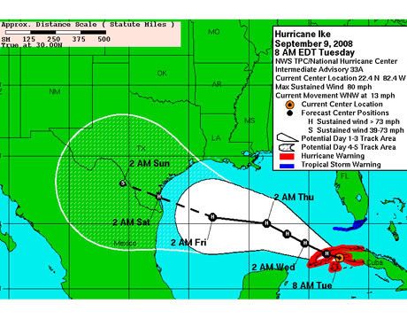
We see this year after year, a storm points one way and last min heads another.

Because your in the Houston area I will use Ike as an example...here is the cone path NHC gave us just 4 days before Ike hit.
Image

Bottom line if you live in the Gulf always be ready!

I myself am not worried about a dirrect Houston/Galveston hit.I am more worried about a much over due Matagorda hit...which would put Houston on the Dirty side.

But IMO if he pulls through the night we could see what I would call a small Storm...it's too early in the season to see something big that's just MO
0 likes   

User avatar
ROCK
Category 5
Category 5
Posts: 9484
Age: 54
Joined: Tue Aug 17, 2004 7:30 am
Location: Kemah, Texas

Re: Re:

#1332 Postby ROCK » Tue Jul 26, 2011 4:10 pm

KWT wrote:
gatorcane wrote:When are the models going to start picking up on this system?

What are they seeing that is not causing them to develop it?


Well it may well be a small system and its in a fairly complex upper pattern with several ULLs/TUTTs not being that far away, I'm just guessing they think one of those features will end up preventing it from developing.


really flying blind right now with no models....NAM seems good so far....
0 likes   

User avatar
tropicwatch
Category 5
Category 5
Posts: 3389
Age: 61
Joined: Sat Jun 02, 2007 10:01 am
Location: Panama City Florida
Contact:

Re: ATL: INVEST 90L - Discussion

#1333 Postby tropicwatch » Tue Jul 26, 2011 4:12 pm

Here is some recent buoy data. The distance is from the point of
20.5N 83.4W

ID TIME LAT LON DIST HDG WDIR WSPD GST WVHT DPD APD MWD PRES PTDY
------------------------------------------------------------------------------------------------------------------------------------------------------------------------------------------------------------------------------------------------
42056 1950 19.80 -84.86 92 243 100 7.8 9.7 2.3 8 5.1 108 29.83 -0.05
42057 1950 17.00 -81.50 236 152 110 11.7 13.6 4.3 8 5.8 94 29.81 -

Tropicwatch
Last edited by tropicwatch on Tue Jul 26, 2011 4:21 pm, edited 1 time in total.
0 likes   

User avatar
KWT
Category 5
Category 5
Posts: 31415
Joined: Tue Aug 17, 2004 11:02 am
Location: UK!!!

#1334 Postby KWT » Tue Jul 26, 2011 4:13 pm

Nice looking system, still waiting for one solid clump of convection to actually hold and not collapse, I think once that happens thats when you'll get an established LLC. The last burst started off the process, this burst is at least maintaining it, but we aren't quite the full way there yet.

Its got time to become a hurricane, but it'll have to somewhat threat the eye of the needle still when it comes to the shear zone...if it does then it'll have good outflow support.
0 likes   
Personal Forecast Disclaimer:
The posts in this forum are NOT official forecast and should not be used as such. They are just the opinion of the poster and may or may not be backed by sound meteorological data. They are NOT endorsed by any professional institution or storm2k.org. For official information, please refer to the NHC and NWS products

User avatar
Tireman4
S2K Supporter
S2K Supporter
Posts: 5853
Age: 59
Joined: Fri Jun 30, 2006 1:08 pm
Location: Humble, Texas
Contact:

Re: ATL: INVEST 90L - Models

#1335 Postby Tireman4 » Tue Jul 26, 2011 4:19 pm

wxman57 wrote:


We know where it's NOT going, then.


Model smackdown...woo hoo...I love it...
0 likes   

tolakram
Admin
Admin
Posts: 20012
Age: 62
Joined: Sun Aug 27, 2006 8:23 pm
Location: Florence, KY (name is Mark)

Re: ATL: INVEST 90L - Discussion

#1336 Postby tolakram » Tue Jul 26, 2011 4:20 pm

Code: Select all

3:50 pm    NE ( 49 deg )    0.4 kts
3:40 pm    W ( 278 deg )    2.5 kts
3:30 pm    WNW ( 295 deg )    2.7 kts
3:20 pm    NW ( 307 deg )    3.9 kts
3:10 pm    ESE ( 104 deg )    1.6 kts
3:00 pm    E ( 80 deg )    6.0 kts


Image

http://www.ndbc.noaa.gov/station_page.php?station=42056
0 likes   
M a r k
- - - - -
Join us in chat: Storm2K Chatroom Invite. Android and IOS apps also available.

The posts in this forum are NOT official forecasts and should not be used as such. Posts are NOT endorsed by any professional institution or STORM2K.org. For official information and forecasts, please refer to NHC and NWS products.

User avatar
tropicwatch
Category 5
Category 5
Posts: 3389
Age: 61
Joined: Sat Jun 02, 2007 10:01 am
Location: Panama City Florida
Contact:

#1337 Postby tropicwatch » Tue Jul 26, 2011 4:25 pm

I don't know how accurate it is but Pinar del Rio, CU is reporting a pressure of 29.70.
0 likes   

User avatar
NDG
S2K Supporter
S2K Supporter
Posts: 15446
Joined: Sun Jul 09, 2006 10:14 pm
Location: Orlando, FL

Re: Re:

#1338 Postby NDG » Tue Jul 26, 2011 4:28 pm

wxman57 wrote:
Portastorm wrote:For you newbies, Air Force Met is one of our fine meteorologists and a longtime Storm2K member. AFM doesn't post a lot ... but when he does, you best listen up and take note!

AFM -- thanks mucho for your thoughts and we look forward to any further comments!


I actually had lunch with AFM today. I respect his opinion very much. Great meteorologist. We're on the same page regarding potential development and track. No reason for a special NHC outlook, unless it's to admit that development chances are better than not. No well-defined LLC yet. In fact, the buoy SW of the "center" now has and ESE wind at 10 kts. You wouldn't expect that if an LLC had become well-established.


Buoy 42056 now reporting calm winds, in the last hour it has gone light and variable, even one point in the last hour of a very light W and or NW winds for a period of 20 minutes. That's good enough for me of an indication that to the NE of it there might be a closed circulation trying to get going knowing that the SW quadrant of a developing LLC is the weakest quadrant when it comes to winds, most times. IMO.

Conditions at 42056 as of
(3:50 pm CDT)
2050 GMT on 07/26/2011:
Wind Speed (WSPD): 0.0 kts
Wind Gust (GST): 1.9 kts
Wave Height (WVHT): 2.3 ft
Dominant Wave Period (DPD): 6 sec
Average Period (APD): 5.0 sec
Mean Wave Direction (MWD): E ( 80 deg true )
Atmospheric Pressure (PRES): 29.82 in
Pressure Tendency (PTDY): -0.04 in ( Falling )
Air Temperature (ATMP): 84.4 °F
Water Temperature (WTMP): 87.6 °F
Dew Point (DEWP): 75.4 °F
Heat Index (HEAT): 92.8 °F
Combined plot of Wind Speed, Gust, and Air Pressure
Continuous Winds TIME
(CDT) WDIR WSPD
3:50 pm NE ( 49 deg ) 0.4 kts
3:40 pm W ( 278 deg ) 2.5 kts
3:30 pm WNW ( 295 deg ) 2.7 kts
3:20 pm NW ( 307 deg ) 3.9 kts
3:10 pm ESE ( 104 deg ) 1.6 kts
3:00 pm E ( 80 deg ) 6.0 kts
Supplemental Measurements Highest 1-minute Wind Speed
Time (CDT) WSPD WDIR
3:50 pm 7.8 kts E ( 90 deg true )
Last edited by NDG on Tue Jul 26, 2011 4:47 pm, edited 1 time in total.
0 likes   

Stormcenter
S2K Supporter
S2K Supporter
Posts: 6684
Joined: Wed Sep 03, 2003 11:27 am
Location: Houston, TX

#1339 Postby Stormcenter » Tue Jul 26, 2011 4:29 pm

Sorry but I don't trust any of the models this far out anyway. I've never have and never will. JMHO
0 likes   

User avatar
TropicalAnalystwx13
Category 5
Category 5
Posts: 2109
Age: 28
Joined: Tue Jul 19, 2011 8:20 pm
Location: Wilmington, NC
Contact:

Re:

#1340 Postby TropicalAnalystwx13 » Tue Jul 26, 2011 4:29 pm

panamatropicwatch wrote:I don't know how accurate it is but Pinar del Rio, CU is reporting a pressure of 29.70.


Do you have something that shows that?
0 likes   


Return to “2011”

Who is online

Users browsing this forum: No registered users and 5 guests