
ATL: DON - Remnant - Discussion
Moderator: S2k Moderators
-
southerngale

- Retired Staff

- Posts: 27418
- Joined: Thu Oct 10, 2002 1:27 am
- Location: Southeast Texas (Beaumont area)

 my Cowboys

-
southerngale
- Retired Staff
- Posts: 27418
- Joined: Thu Oct 10, 2002 1:27 am
- Location: Southeast Texas (Beaumont area)

Re: ATL: INVEST 90L - Discussion
Looks like this has a good pool of unstable air to feed from. CAPE over 3000 NW of Jamaica.
I ran a couple HYSPLIT trajectories based on GFS and not really seeing good ascent at the moment around this.
May take a little time to ramp up.
UL winds are not that great at the moment as well with no anti-cyclone.
I ran a couple HYSPLIT trajectories based on GFS and not really seeing good ascent at the moment around this.
May take a little time to ramp up.
UL winds are not that great at the moment as well with no anti-cyclone.
0 likes
-
cycloneye

- Admin

- Posts: 149435
- Age: 69
- Joined: Thu Oct 10, 2002 10:54 am
- Location: San Juan, Puerto Rico
Re: ATL: INVEST 90L - Discussion
Here is this morning's discussion by Rob of Crown Weather about 90L:
The following post is NOT an official forecast and should not be used as such. It is just the opinion of the poster and may or may not be backed by sound meteorological data. It is NOT endorsed by any professional institution including storm2k.org. For Official Information please refer to the NHC and NWS products.
http://www.crownweather.com/?page_id=4557
Invest 90-L Continues To Be Watched For Possible Development In The Southern Gulf Of Mexico On Wednesday & Thursday
Rob Lightbown on July 26, 2011, 5:38 am
After being deactivated for a few hours on Monday, the National Hurricane Center has reactivated Invest 90-L, which is located in the northwestern Caribbean. The reason for this is because convection has increased and expanded during the overnight hours as this system has slowed down considerably in forward speed. This slowdown in forward speed has caused an increase in convergence and has also increased the chances of development into a tropical depression or a tropical storm over the next few days.
This morning’s analysis reveals that the upper level conditions and vertical wind shear values will be favorable for much of the rest of this week. Last night’s SHIPS intensity model was forecasting wind shear values to drop to 10 knots or less by later today and remain that way right through Friday. Satellite imagery this morning from CIMSS is definitely showing an increase in convection and current shear analysis reveals that the current 15 to 20 knots of shear that is over 90-L will quickly drop off as it nears the Yucatan Peninsula tonight into Wednesday where 5 to 10 knots of vertical shear exists. Surface analysis of the northwestern Caribbean shows that there is still a wave axis associated with the convection and an area of low pressure has not developed as of yet.
Ok, here are my thoughts: I expect Invest 90-L to track west-northwestward from today through Friday. This will bring this system onshore onto the coast of northeastern Mexico or south Texas on Friday night. Given the fact that vertical wind shear values of 10 knots or less are already verifying near the Yucatan Peninsula and that relatively favorable environmental conditions are forecast to exist right up to landfall on Friday night, I think that Invest 90-L will organize and develop into first a tropical depression and then a tropical storm. One thing that may really hinder development is dry air noted in water vapor satellite imagery just north of the Bay of Campeche and the Yucatan Peninsula. This really makes forecasting whether this system will develop or not very tricky.
At this point, I’m going to lean a little more on the conservative side and go with slow development into an area of low pressure possibly by late today or tonight and then slow organization and development into a tropical depression when it reaches the southern Gulf of Mexico late Wednesday night or Thursday and then a tropical storm in the western Gulf of Mexico on Friday. At this point, landfall of this system as a 45 to 60 mph tropical storm into northeastern Mexico or south Texas on Friday night is possible.
The reasons why I’m being more on the conservative side is because there is virtually no model guidance that is forecasting development into a tropical cyclone. Also, that dry air in the southern Gulf of Mexico may put a stop to any development and thus may be the reason why the models are not forecasting development.
I will be monitoring Invest 90-L very closely and will keep you all updated on the latest.
0 likes
Visit the Caribbean-Central America Weather Thread where you can find at first post web cams,radars
and observations from Caribbean basin members Click Here
and observations from Caribbean basin members Click Here

Re: ATL: INVEST 90L - Discussion
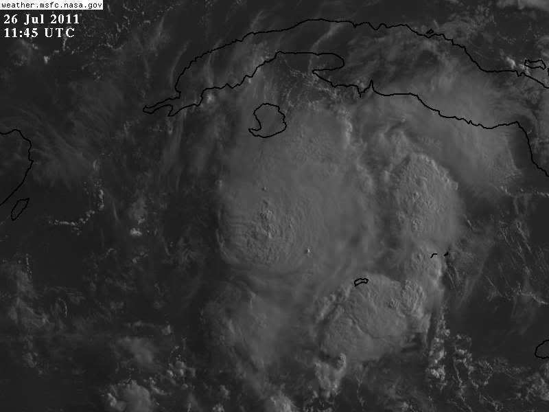
Convection is attempting to fire near the center.
http://rammb.cira.colostate.edu/product ... 260515.jpg
IMHO, what is currently holding this back was a flare over the Yucatan that created a short term UL jet to the SW of the 90L's center.
http://www.ssd.noaa.gov/goes/east/watl/flash-wv.html
The direction of the jet is in opposition for good ventilation.
http://tropic.ssec.wisc.edu/real-time/a ... g8wvir.GIF
The flare has washed itself out and the jet should dissipate soon.
After that, we could see 90L begin to ramp up.
0 likes
Re: ATL: INVEST 90L - Discussion
How quickly can this get back together? I've seen some amazing things happen in that part of the Caribbean (Wilma for one) How much should Cancun be watching this one, I've got family going there later this week.
Looking through the sites, Crown seems like they don't expect much, masters hasn't updated, flhurricane thinks it'll develop before the Yucatan, and there doesn't seem to be too much elsewhere yet.
Looking through the sites, Crown seems like they don't expect much, masters hasn't updated, flhurricane thinks it'll develop before the Yucatan, and there doesn't seem to be too much elsewhere yet.
0 likes


Re: ATL: INVEST 90L - Discussion
I think the reason that everyone hasn't "caught on," or updated their forecasts is because all of this happened so late last night.
0 likes
20% now
TROPICAL WEATHER OUTLOOK
NWS NATIONAL HURRICANE CENTER MIAMI FL
800 AM EDT TUE JUL 26 2011
FOR THE NORTH ATLANTIC...CARIBBEAN SEA AND THE GULF OF MEXICO...
SHOWERS AND THUNDERSTORMS ASSOCIATED WITH A TROPICAL WAVE OVER THE
NORTHWESTERN CARIBBEAN SEA HAVE BECOME MORE CONCENTRATED THIS
MORNING BETWEEN WESTERN CUBA AND THE CAYMAN ISLANDS. SLOW
DEVELOPMENT OF THIS SYSTEM IS POSSIBLE DURING THE NEXT COUPLE OF
DAYS AS IT MOVES TOWARD THE WEST-NORTHWEST AT 10 TO 15 MPH. THIS
SYSTEM HAS A LOW CHANCE...20 PERCENT...OF BECOMING A
TROPICAL CYCLONE DURING THE NEXT 48 HOURS.
ELSEWHERE...TROPICAL CYCLONE FORMATION IS NOT EXPECTED DURING THE
NEXT 48 HOURS.
$$
FORECASTER BEVEN
0 likes

Re: ATL: INVEST 90L - Discussion
One of our local meteorologist just said that 90L is not expected to develop.
0 likes
Re: ATL: INVEST 90L - Discussion
I think the NHC will be careful on how they upgrade 90L. A fews days ago they went to orange and had to go back to yellow the next day,then to 0% and deactivated it yesterday.
0 likes
South of the Isle of Youth, formerly known as the Isle of Pines  , is where you can tell that the vorticity is from looking at the Cuban radar loop.
http://www.met.inf.cu/asp/genesis.asp?TB0=PLANTILLAS&TB1=RADAR&TB2=../Radar/03Cienfuegos/psjMAXw01a.gif
http://www.met.inf.cu/asp/genesis.asp?TB0=PLANTILLAS&TB1=RADAR&TB2=../Radar/03Cienfuegos/psjMAXw01a.gif
0 likes
-
Meso

- Category 5

- Posts: 1609
- Age: 39
- Joined: Mon Aug 09, 2004 12:14 pm
- Location: South Africa
- Contact:
Re: ATL: INVEST 90L - Discussion
Convection continues to become deeper, the first signs of red starting to appear. Convection continues to appear to be consolidating too.

0 likes

-
Aric Dunn
- Category 5
- Posts: 21238
- Age: 43
- Joined: Sun Sep 19, 2004 9:58 pm
- Location: Ready for the Chase.
- Contact:
No evidence of a LLC. Just a sharp wind shift. but I see a lot more inflow and it should only be a matter of time before we see something at the surface especially since the convection has persisted for about 24hours.
0 likes
Note: If I make a post that is brief. Please refer back to previous posts for the analysis or reasoning. I do not re-write/qoute what my initial post said each time.
If there is nothing before... then just ask
Space & Atmospheric Physicist, Embry-Riddle Aeronautical University,
I believe the sky is falling...
If there is nothing before... then just ask
Space & Atmospheric Physicist, Embry-Riddle Aeronautical University,
I believe the sky is falling...
-
cycloneye
- Admin
- Posts: 149435
- Age: 69
- Joined: Thu Oct 10, 2002 10:54 am
- Location: San Juan, Puerto Rico
Re: ATL: INVEST 90L - Discussion
0 likes
Visit the Caribbean-Central America Weather Thread where you can find at first post web cams,radars
and observations from Caribbean basin members Click Here
and observations from Caribbean basin members Click Here
Who is online
Users browsing this forum: No registered users and 26 guests