JMA 5-day:

JTWC 03Z prognostic reasoning:
WDPN31 PGTW 260300
MSGID/GENADMIN/NAVMARFCSTCEN PEARL HARBOR HI/JTWC//
SUBJ/PROGNOSTIC REASONING FOR TROPICAL STORM 10W//
WARNING NR 06//
RMKS/
1. FOR METEOROLOGISTS.
2. 12 HOUR SUMMARY AND ANALYSIS.
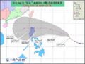
A. TROPICAL STORM (TS) 10W, LOCATED APPROXIMATELY 150 NM EAST-
SOUTHEAST OF MANILA, PHILIPPINES, HAS TRACKED WESTWARD AT 09 KNOTS
OVER THE PAST SIX HOURS. THE SYSTEM HAS MADE A SIGNIFICANT BEND
SOUTH OF THE EXPECTED TRACK DURING THE PAST 12 HOURS DUE TO A STRONG
UPPER LEVEL RIDGE TO THE NORTHEAST OF LUZON. SURFACE REPORTS FROM
THE CATANDUANES RADAR SITE CONFIRM THAT THE LOW LEVEL CIRCULATION
CENTER PASSED NORTH OF THE SITE. RECENT ANIMATED MULTISPECTRAL
SATELLITE IMAGERY SHOWS SOME INTENSIFICATION IN CONVECTION AROUND
THE LOW LEVEL CIRCULATION CENTER (LLCC). A 252043Z SSMIS IMAGE SHOWS
CLEAR ORGANIZATION AROUND THE LLCC, BUT THE MAJORITY OF DEEP
CONVECTION IS ASSOCIATED WITH LAND INTERACTION ON THE PERIPHERY OF
THE SYSTEM. TS 10W IS STILL STRUGGLING TO INTENSIFY AGAINST THE
EFFECTS OF STRONG SUBSIDENCE OVER THE NORTHERN SEMICIRCLE. ANIMATED
WATER VAPOR IMAGERY REVEALS THE SEVERE DEGREE OF SUPPRESSION TO
POLEWARD OUTFLOW. EQUATORWARD OUTFLOW REMAINS WELL ESTABLISHED,
HOWEVER, AND NET VERTICAL WIND SHEAR OVER THE SYSTEM REMAINS AT
APPROXIMATELY 15 KNOTS. A 252043Z 37 GHZ SSMIS IMAGE CONFIRMS
SIGNIFICANTLY BETTER ORGANIZATION IN THE LOW LEVEL BANDING, BUT THE
91 GHZ IMAGE SHOWS THAT THE VAST MAJORITY OF DEEP CONVECTION IS
ASSOCIATED WITH LAND INTERACTION. EARLIER ASCAT IMAGERY CONFIRMED
BROAD SWATHS OF 25-30 KNOT WINDS EXTENDING OVER 100 NM AWAY FROM THE
LLCC. SURFACE REPORTS FROM COASTAL STATIONS IN COASTAL SAMAR AND
LUZON SHOW OFF-SHORE WINDS RISING AND PRESSURES FALLING. THE CURRENT
INTENSITY ESTIMATE IS BASED ON DVORAK ANALYSES OF 35 KNOTS FROM KNES
AND PGTW.
B. THE EXTREMELY WARM WATERS OF THE PHILIPPINE SEA AND EXCELLENT
EQUATORWARD OUTFLOW WILL COMPENSATE FOR THE SUPPRESSED POLEWARD
OUTFLOW AND HELP THE SYSTEM INTENSIFY TO TROPICAL STORM STRENGTH
BEFORE LANDFALL. THE SUBTROPICAL RIDGE, CURRENTLY CENTERED OVER THE
BONIN ISLANDS, IS RETROGRADING SOUTHEASTWARD AND BEGINNING TO
INFLUENCE THE COURSE OF TS 10W TO A GREATER EXTENT. THE STEERING
FORCE WILL DRIVE THE SYSTEM ASHORE OVER CENTRAL LUZON NEAR TAU 18.
TS 10W WILL WEAKEN SIGNIFICANTLY AS IT TRACKS ACROSS LUZON AND TAKE
SOME TIME TO RE-GATHER STRENGTH ONCE IT ENTERS THE SOUTH CHINA SEA.
MODEL GUIDANCE HAS STABILIZED AND IS COMING INTO MUCH STRONGER
AGREEMENT REGARDING TRACK. ALL CONSENSUS MEMBERS ARE NOW SHOWING A
TRACK ACROSS NORTHERN LUZON AND AN EXIT INTO THE SOUTH CHINA SEA
SOMEWHERE NEAR OR JUST SOUTH OF THE LINGAYEN GULF. ALTHOUGH
SOUTHWESTERLY WINDS REPRESENT THE BIGGEST HAZARD TO SUBIC BAY, THE
DEGRADED INTENSITY OF THE SYSTEM IS NOT LIKELY TO RESULT IN A SEVERE
WIND EVENT. AS THE STORM MOVES AWAY FROM LUZON, THE SEASONAL
ANTICYCLONE OVER EASTERN CHINA WILL BEGIN STEERING THE SYSTEM ON A
MORE WESTWARD COURSE, AS WELL AS BRING INCREASED SHEAR TO THE
EQUATION. SEA SURFACE TEMPERATURES OVER THE NORTHERN SOUTH CHINA SEA
WILL SUPPORT RE-INTENSIFICATION BUT THE INCREASED SHEAR WILL KEEP
THE DEVELOPMENT SLOW AND MILD.
C. TS 10W WILL STAY SEAWARD OF THE CHINESE COAST, TRACKING
OVER NORTHERN HAINAN OR THE LUICHOW PENINSULA AS IT MOVES INTO THE
GULF OF TONKIN. ALTHOUGH SEA SURFACE TEMPERATURES WILL REMAIN HIGH
THROUGHOUT THE TRACK, THE COMBINED EFFECTS OF EASTERLY SHEAR ALOFT
AND LAND INTERACTION IN THE BOUNDARY LEVELS WILL COUPLE TO SLOWLY
WEAKEN THE SYSTEM BEFORE LANDFALL. MODEL GUIDANCE IS COMING INTO
GOOD AGREEMENT ON TRACK. THE JTWC TRACK FORECAST STAYS WITH
CONSENSUS.//
NNNN