ATL: DON - Remnant - Discussion

Moderator: S2k Moderators

Message
Author
User avatar
perk
Category 3
Category 3
Posts: 825
Joined: Mon Aug 09, 2004 9:35 am
Location: Richmond Texas

Re: ATL: INVEST 90L - Discussion

#441 Postby perk » Sat Jul 23, 2011 7:15 pm

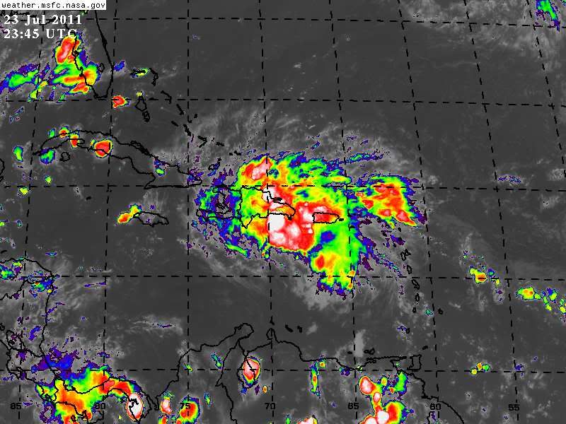
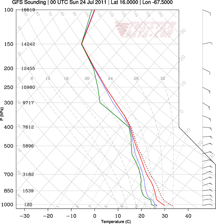
wxman57 wrote:I'd put it along 68W as of 6PM CDT, maybe 16N, but there is definitely no LLC yet. Just a wave axis. Convection is expanding and outflow improving. Note that 850mb winds in its immediate path increase to 25-30 kts, or more. Not good for near-term development, but those winds forecast to drop to 15 kts near the Yucatan. That is good for low-level convergence. GFS and Euro move the ridge over Texas east to the Carolinas by Thursday, opening up the western Gulf for a northerly turn toward TX if it does develop, or even if it doesn't develop.


Thanks wxman57 for your thoughts on development and guidance.
0 likes   

User avatar
NDG
S2K Supporter
S2K Supporter
Posts: 15446
Joined: Sun Jul 09, 2006 10:14 pm
Location: Orlando, FL

#442 Postby NDG » Sat Jul 23, 2011 7:32 pm

Land interaction with Hispaniola and later with Cuba than wind shear looks to be the biggest inhibitor for further development over the next day or two.

Sattelite picture
Image
Last edited by NDG on Sat Jul 23, 2011 7:41 pm, edited 2 times in total.
0 likes   

User avatar
cycloneye
Admin
Admin
Posts: 145303
Age: 68
Joined: Thu Oct 10, 2002 10:54 am
Location: San Juan, Puerto Rico

Re:

#443 Postby cycloneye » Sat Jul 23, 2011 7:37 pm

NDG wrote:Land interaction with Hispaniola and later with Cuba than wind shear looks to be the biggest inhibitor for further development over the next day or two.

Sattelite picture


I made the link as hyperlink as it was streching the post.
0 likes   
Visit the Caribbean-Central America Weather Thread where you can find at first post web cams,radars
and observations from Caribbean basin members Click Here

stormreader

Re: ATL: INVEST 90L - Discussion

#444 Postby stormreader » Sat Jul 23, 2011 7:42 pm

You can see from the recent sat photo posted by NDG that it is starting to get "that look". Very unscientific, I know. But compared to the way the system "looked" 48 hours ago, I would say that it has become much more ominous.
0 likes   

User avatar
HURAKAN
Professional-Met
Professional-Met
Posts: 46086
Age: 38
Joined: Thu May 20, 2004 4:34 pm
Location: Key West, FL
Contact:

Re: ATL: INVEST 90L - Discussion

#445 Postby HURAKAN » Sat Jul 23, 2011 8:03 pm

stormreader wrote:You can see from the recent sat photo posted by NDG that it is starting to get "that look". Very unscientific, I know. But compared to the way the system "looked" 48 hours ago, I would say that it has become much more ominous.


There is nothing that lies more than a satellite image. Our brains are designed to recognize patterns and if it looks like a tropical cyclone, we think it's. But the true story is at the surface and based surface obs, this system is not getting any better organized at the moment. Pressures are high and it's running into high shear and mountainous terrain. Any development is likely to occur after it crosses the central Caribbean

Image
0 likes   

User avatar
BigA
Professional-Met
Professional-Met
Posts: 1317
Joined: Sun Jul 24, 2005 10:56 pm

Re: ATL: INVEST 90L - Discussion

#446 Postby BigA » Sat Jul 23, 2011 8:17 pm

Vorticity on the wax again south of Puerto Rico, a bit stronger at the 700 mb level than 850

http://tropic.ssec.wisc.edu/real-time/w ... oom=&time=

Things thing is persistent; I don't expect anything until after it passes Jamaica, but then its a whole new ballgame.
0 likes   

User avatar
tailgater
S2K Supporter
S2K Supporter
Posts: 3339
Joined: Sun Jul 11, 2004 9:13 pm
Location: St. Amant La.

Re: ATL: INVEST 90L - Discussion

#447 Postby tailgater » Sat Jul 23, 2011 8:51 pm

someone please show this shear. I don't see it in the wv loop or on CIMSS charts.
0 likes   
The following post is NOT an official forecast and should not be used as such. It is just the opinion of the poster and may or may not be backed by sound meteorological data. It is NOT endorsed by any professional institution including storm2k.org For Official Information please refer to the NHC and NWS products.

User avatar
TwisterFanatic
Category 5
Category 5
Posts: 1041
Joined: Mon Jun 28, 2010 12:43 pm
Location: Sallisaw, Oklahoma

Re: ATL: INVEST 90L - Discussion

#448 Postby TwisterFanatic » Sat Jul 23, 2011 8:59 pm

tailgater wrote:someone please show this shear. I don't see it in the wv loop or on CIMSS charts.


I don't see it either, I do see land interaction that is hindering this from developing further. The wave does look to have some nice outflow right now though.
0 likes   
Personal Forecast Disclaimer:
The posts in this forum are NOT official forecast and should not be used as such. They are just the opinion of the poster and may or may not be backed by sound meteorological data. They are NOT endorsed by any professional institution or storm2k.org. For official information, please refer to the NHC and NWS products.

User avatar
HURAKAN
Professional-Met
Professional-Met
Posts: 46086
Age: 38
Joined: Thu May 20, 2004 4:34 pm
Location: Key West, FL
Contact:

#449 Postby HURAKAN » Sat Jul 23, 2011 9:11 pm

Image

10-20 knots, add 15 knots to compensate the motion of the system against the shear and you get 25-35 knots of wind shear.

Cindy was on a high shear environment but it was moving with the shear, so essentially it was able to partially cancel most of the shear effect and develop.
0 likes   

User avatar
HURAKAN
Professional-Met
Professional-Met
Posts: 46086
Age: 38
Joined: Thu May 20, 2004 4:34 pm
Location: Key West, FL
Contact:

#450 Postby HURAKAN » Sat Jul 23, 2011 9:17 pm

Image

Santo Domingo, DR
0 likes   

User avatar
TwisterFanatic
Category 5
Category 5
Posts: 1041
Joined: Mon Jun 28, 2010 12:43 pm
Location: Sallisaw, Oklahoma

#451 Postby TwisterFanatic » Sat Jul 23, 2011 9:18 pm

I see it now.. Really can't tell by looking at the WV loop.
0 likes   
Personal Forecast Disclaimer:
The posts in this forum are NOT official forecast and should not be used as such. They are just the opinion of the poster and may or may not be backed by sound meteorological data. They are NOT endorsed by any professional institution or storm2k.org. For official information, please refer to the NHC and NWS products.

User avatar
South Texas Storms
Professional-Met
Professional-Met
Posts: 4226
Joined: Thu Jun 24, 2010 12:28 am
Location: Houston, TX

Re: ATL: INVEST 90L - Discussion

#452 Postby South Texas Storms » Sat Jul 23, 2011 9:19 pm

:uarrow: Very humid and some good CAPE (convective available potential energy) there.
0 likes   

User avatar
NDG
S2K Supporter
S2K Supporter
Posts: 15446
Joined: Sun Jul 09, 2006 10:14 pm
Location: Orlando, FL

Re:

#453 Postby NDG » Sat Jul 23, 2011 9:22 pm

HURAKAN wrote:Image

10-20 knots, add 15 knots to compensate the motion of the system against the shear and you get 25-35 knots of wind shear.

Cindy was on a high shear environment but it was moving with the shear, so essentially it was able to partially cancel most of the shear effect and develop.


"Relative" wind shear is already incorporated in UW-CIMSS wind shear graphics.
If you look at Santo Domingo's sounding from tonight, it shows nothing but easterly winds in the upper levels of the atmosphere.

Image
0 likes   

User avatar
tailgater
S2K Supporter
S2K Supporter
Posts: 3339
Joined: Sun Jul 11, 2004 9:13 pm
Location: St. Amant La.

Re: ATL: INVEST 90L - Discussion

#454 Postby tailgater » Sat Jul 23, 2011 9:23 pm

I'm think that shows 10 to 20 kts. because of the different direction at lower and upper levels but not in addition to. The wv loop shows good outflow from 65w to 75w in the general area of this disturbance.
Image

Sorry NDG I didn't see your post before I hit send.
0 likes   
The following post is NOT an official forecast and should not be used as such. It is just the opinion of the poster and may or may not be backed by sound meteorological data. It is NOT endorsed by any professional institution including storm2k.org For Official Information please refer to the NHC and NWS products.

User avatar
TwisterFanatic
Category 5
Category 5
Posts: 1041
Joined: Mon Jun 28, 2010 12:43 pm
Location: Sallisaw, Oklahoma

Re: ATL: INVEST 90L - Discussion

#455 Postby TwisterFanatic » Sat Jul 23, 2011 9:28 pm

South Texas Storms wrote::uarrow: Very humid and some good CAPE (convective available potential energy) there.


Yea, fuel is definitely not the problem for this system.
0 likes   
Personal Forecast Disclaimer:
The posts in this forum are NOT official forecast and should not be used as such. They are just the opinion of the poster and may or may not be backed by sound meteorological data. They are NOT endorsed by any professional institution or storm2k.org. For official information, please refer to the NHC and NWS products.

User avatar
NDG
S2K Supporter
S2K Supporter
Posts: 15446
Joined: Sun Jul 09, 2006 10:14 pm
Location: Orlando, FL

#456 Postby NDG » Sat Jul 23, 2011 9:28 pm

Definite no westerly winds in the upper levels with 90L in the area of its H85 vorticity. 5-10 knots of wind shear max at the most is a good bet.

Image
Last edited by NDG on Sat Jul 23, 2011 9:35 pm, edited 1 time in total.
0 likes   

User avatar
tailgater
S2K Supporter
S2K Supporter
Posts: 3339
Joined: Sun Jul 11, 2004 9:13 pm
Location: St. Amant La.

Re: ATL: INVEST 90L - Discussion

#457 Postby tailgater » Sat Jul 23, 2011 9:35 pm

This might the main problem, as to why no development in the short term.
Image
0 likes   
The following post is NOT an official forecast and should not be used as such. It is just the opinion of the poster and may or may not be backed by sound meteorological data. It is NOT endorsed by any professional institution including storm2k.org For Official Information please refer to the NHC and NWS products.

User avatar
HURAKAN
Professional-Met
Professional-Met
Posts: 46086
Age: 38
Joined: Thu May 20, 2004 4:34 pm
Location: Key West, FL
Contact:

#458 Postby HURAKAN » Sat Jul 23, 2011 9:37 pm

Image

not much at the surface ... convection driven by divergence aloft, not much convergence at the surface
0 likes   

User avatar
TwisterFanatic
Category 5
Category 5
Posts: 1041
Joined: Mon Jun 28, 2010 12:43 pm
Location: Sallisaw, Oklahoma

#459 Postby TwisterFanatic » Sat Jul 23, 2011 9:47 pm

So far through 72 hours, the NAM has went noticeably further south..

Image
0 likes   
Personal Forecast Disclaimer:
The posts in this forum are NOT official forecast and should not be used as such. They are just the opinion of the poster and may or may not be backed by sound meteorological data. They are NOT endorsed by any professional institution or storm2k.org. For official information, please refer to the NHC and NWS products.

User avatar
NDG
S2K Supporter
S2K Supporter
Posts: 15446
Joined: Sun Jul 09, 2006 10:14 pm
Location: Orlando, FL

#460 Postby NDG » Sat Jul 23, 2011 9:51 pm

Tonight definitely no 00z tropical models ran.
0 likes   


Return to “2011”

Who is online

Users browsing this forum: No registered users and 30 guests