
Very interesting runs, I'd be amazed if that comes off however given its current presentation!
Still shows what may pccur down the line if conditions are better in the S.Gulf as expected.
ATL: DON - Remnant - Discussion
Moderator: S2k Moderators
0 likes
Personal Forecast Disclaimer:
The posts in this forum are NOT official forecast and should not be used as such. They are just the opinion of the poster and may or may not be backed by sound meteorological data. They are NOT endorsed by any professional institution or storm2k.org. For official information, please refer to the NHC and NWS products
The posts in this forum are NOT official forecast and should not be used as such. They are just the opinion of the poster and may or may not be backed by sound meteorological data. They are NOT endorsed by any professional institution or storm2k.org. For official information, please refer to the NHC and NWS products


Re: ATL: INVEST 90L - Discussion
Sanibel wrote:Looks like a d-max re-fire of convection.
I meant the models appear to be trending more towards Texas than yesterday.
Thanks that clears it up for me.
0 likes
-
stormreader
Re:
BigA wrote:Seems to me that this has a better shot if it stays south of the Greater Antilles, given that UL conditions are more likely to be favorable in the W.Carib than the Bahamas in 48-72 hours.
The 12Z GFDL and HWRF runs, and the FOX WRF run http://weather.myfoxtampabay.com/maps/W ... shear.html seem to bear this out. It has to stay south of Hispaniola and Cuba to have a chance.
I think it will stay south of Haiti and Cuba. Just looking at latest loops from NHC, looks like llc is becoming more apparent at the southern end of that expanding mass of convection. Perhaps just my imagination. Maybe a closer look would tell.
http://www.ssd.noaa.gov/goes/east/tatl/flash-vis.html
0 likes
-
Rgv20

- S2K Supporter

- Posts: 2466
- Age: 39
- Joined: Wed Jan 05, 2011 5:42 pm
- Location: Edinburg/McAllen Tx
90L should keep moving should keep moving WNW at a fairly brisk pace thru at least the next 72hrs. After that it should begin to slow down as it reaches the NW Caribbean or SE GOM by Tuesday Evening.
Steering forecast thru 48hrs
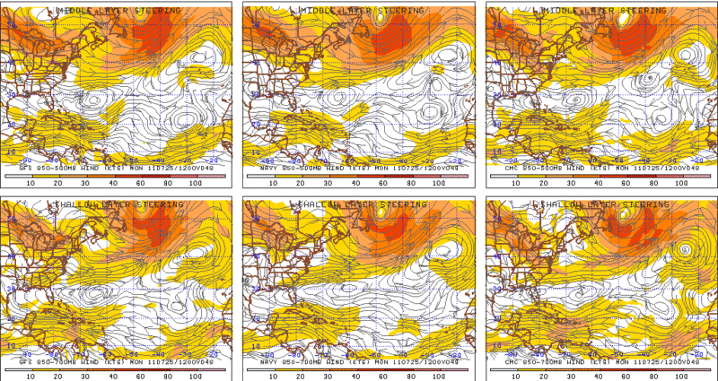
Thru 72hrs
Just looked at the 12zGFDL and HWRF and they have a full blown hurricane by 84hrs. Its likely to bullish with the intensity but it looks like both models are trying to hint of what 90l could become.
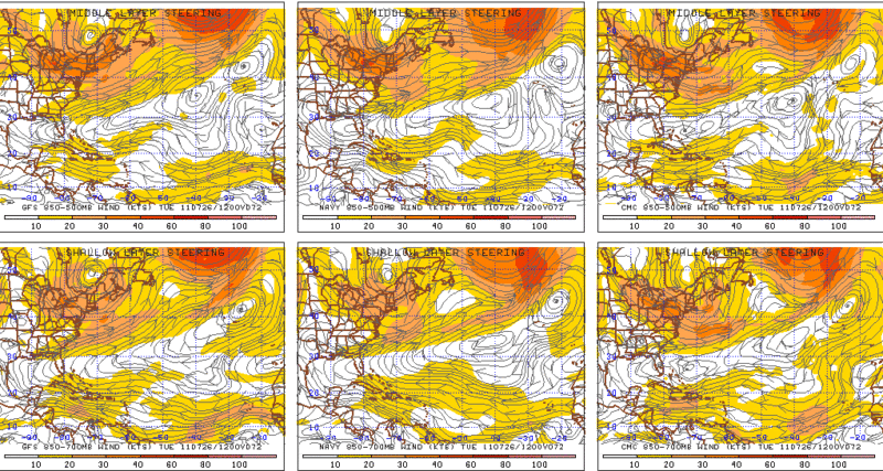
Steering forecast thru 48hrs
Thru 72hrs
Just looked at the 12zGFDL and HWRF and they have a full blown hurricane by 84hrs. Its likely to bullish with the intensity but it looks like both models are trying to hint of what 90l could become.
0 likes
The following post is NOT an official forecast and should not be used as such. It is just the opinion of the poster and may or may not be backed by sound meteorological data. It is NOT endorsed by any professional institution including storm2k.org For Official Information please refer to the NHC and NWS products.
-
stormreader
Re: ATL: INVEST 90L - Discussion
But you know RGV, I'm not too surprised at that bullish model forecast for hurricane in 84 hours. LLC which we saw hints of yesterday is I think becoming quite a bit more pronounced at the southerly end of that convection in the Carribean. And I think the convection is beginning to get over the top of what looks like a burgeoning LLC too. I think the yellow marker may need to be upgraded pretty soon.
0 likes
-
Rgv20
- S2K Supporter
- Posts: 2466
- Age: 39
- Joined: Wed Jan 05, 2011 5:42 pm
- Location: Edinburg/McAllen Tx
How do you like this for a consensus! 
0 likes
The following post is NOT an official forecast and should not be used as such. It is just the opinion of the poster and may or may not be backed by sound meteorological data. It is NOT endorsed by any professional institution including storm2k.org For Official Information please refer to the NHC and NWS products.
-
wxman57

- Moderator-Pro Met

- Posts: 23174
- Age: 68
- Joined: Sat Jun 21, 2003 8:06 pm
- Location: Houston, TX (southwest)
Re: ATL: INVEST 90L - Discussion
I think that development chances next 48 hours are minimal, perhaps 5%. But wait until it reaches the NW Caribbean in 3 days when convergence increases. That's when development chances go up considerably (Monday night/Tue). Recon may well be needed by Monday afternoon.
0 likes
-
tropicwatch

- Category 5

- Posts: 3426
- Age: 62
- Joined: Sat Jun 02, 2007 10:01 am
- Location: The Villages, Florida
- Contact:
Re: ATL: INVEST 90L - Models
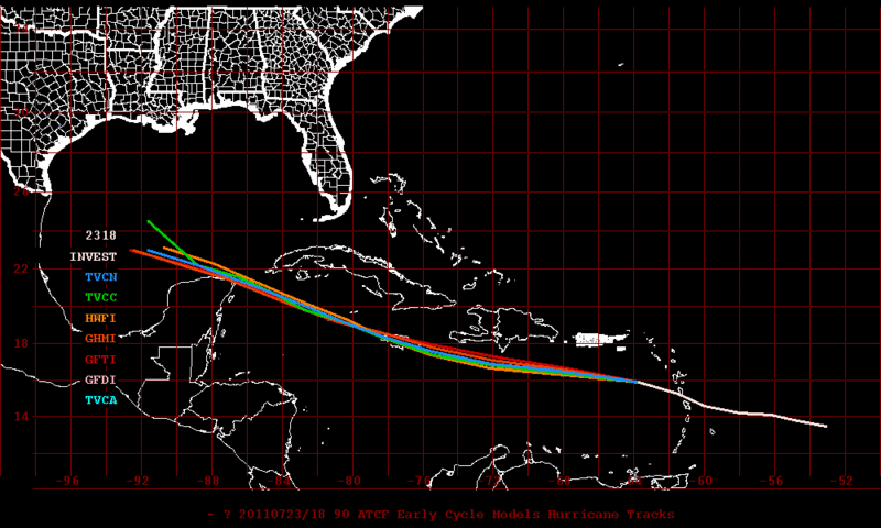
Wow, real close agreement on the model tracks. I don't recall them being like that for a system that hasn't developed yet.
Tropicwatch
Tropicwatch
0 likes
-
TwisterFanatic

- Category 5
- Posts: 1041
- Joined: Mon Jun 28, 2010 12:43 pm
- Location: Sallisaw, Oklahoma
Nice development of some fairly deep convection over and South East of PR the past few frames, still has a long way to go though.
0 likes
Personal Forecast Disclaimer:
The posts in this forum are NOT official forecast and should not be used as such. They are just the opinion of the poster and may or may not be backed by sound meteorological data. They are NOT endorsed by any professional institution or storm2k.org. For official information, please refer to the NHC and NWS products.
The posts in this forum are NOT official forecast and should not be used as such. They are just the opinion of the poster and may or may not be backed by sound meteorological data. They are NOT endorsed by any professional institution or storm2k.org. For official information, please refer to the NHC and NWS products.
-
TwisterFanatic
- Category 5
- Posts: 1041
- Joined: Mon Jun 28, 2010 12:43 pm
- Location: Sallisaw, Oklahoma
Still skeptical of the model tracks due to the Tropical waves overall presentation right now.
0 likes
Personal Forecast Disclaimer:
The posts in this forum are NOT official forecast and should not be used as such. They are just the opinion of the poster and may or may not be backed by sound meteorological data. They are NOT endorsed by any professional institution or storm2k.org. For official information, please refer to the NHC and NWS products.
The posts in this forum are NOT official forecast and should not be used as such. They are just the opinion of the poster and may or may not be backed by sound meteorological data. They are NOT endorsed by any professional institution or storm2k.org. For official information, please refer to the NHC and NWS products.
-
Dean4Storms
- S2K Supporter
- Posts: 6358
- Age: 63
- Joined: Sun Aug 31, 2003 1:01 pm
- Location: Miramar Bch. FL
-
ConvergenceZone
.gif)
- Category 5
- Posts: 5241
- Joined: Fri Jul 29, 2005 1:40 am
- Location: Northern California
Re: ATL: INVEST 90L - Discussion
MGC wrote:Looks like the shear monster is starting to roar over 90L, that and land will kill any development chance the next couple of days. Maybe when the wave enters the GOM....MGC
I agree MGC, this thing is dead until it hits the GOM, then MAYBE it has a chance.
0 likes
-
chrisnnavarre
- Category 1

- Posts: 309
- Joined: Fri Oct 03, 2003 5:52 pm
- Contact:
-
HouTXmetro

- Category 5
- Posts: 3949
- Joined: Sun Jun 13, 2004 6:00 pm
- Location: District of Columbia, USA
Wow, talk about agreement, I'd be very concerned if I were anywhere near the texas mexico border region....off you extrapolate the models looks to head towards the area just south of brownsville...but of course things can change.
0 likes
[Disclaimer: My Amateur Opinion, please defer to your local authorities or the NHC for Guidance.]
Re: ATL: INVEST 90L - Discussion
wxman57 wrote:I think that development chances next 48 hours are minimal, perhaps 5%. But wait until it reaches the NW Caribbean in 3 days when convergence increases. That's when development chances go up considerably (Monday night/Tue). Recon may well be needed by Monday afternoon.
wxman57 any thoughts you can share on 90L's future track.
0 likes
-
stormreader
Re:
chrisnnavarre wrote:Even with the shear, it sure looks like it's coming together around 16N 64W...just saying...if it stays south of the islands this could be our first major player into the Western Caribbean this season.
I agree Chris. By my eye its around 16N66W. At any rate it does look like its making considerable progress today both in developing a circulation and in getting the convection over the top of that circulation. True, it may not develop until it reaches the W Carib, ( my earlier thoughts today said central Cuba area)but it looks like its definitely laying the groundwork today for tropical development.
0 likes

Re:
chrisnnavarre wrote:Even with the shear, it sure looks like it's coming together around 16N 64W...just saying...if it stays south of the islands this could be our first major player into the Western Caribbean this season.
Not even close...
http://rammb.cira.colostate.edu/ramsdis ... opical.asp
0 likes
-
chrisnnavarre
- Category 1
- Posts: 309
- Joined: Fri Oct 03, 2003 5:52 pm
- Contact:
Re: Re:
ROCK wrote:chrisnnavarre wrote:Even with the shear, it sure looks like it's coming together around 16N 64W...just saying...if it stays south of the islands this could be our first major player into the Western Caribbean this season.
Not even close...look below the convection as its being sheared out to the NE....low level to mid level vorticty...around 15N 65W...speed it up....
http://rammb.cira.colostate.edu/ramsdis ... opical.asp
Yep, I see the shear too. Still looks like a circulation down there, and convection is increasing. Anyone know what the nearest pressure readings are now? Is there a weather station near by, or a buoy perhaps?
0 likes
-
Ivanhater

- Storm2k Moderator

- Posts: 11221
- Age: 39
- Joined: Fri Jul 01, 2005 8:25 am
- Location: Pensacola
Re: ATL: INVEST 90L - Discussion
Wxman looks spot on. Convection is not a problem, the issue is the strong easterly flow over the eastern Caribbean right now not allowing a surface circulation to form. Once this slows in the Western Caribbean, the convection will be allowed to pop a surface low.
0 likes
Michael
-
Tireman4

- S2K Supporter
- Posts: 5903
- Age: 60
- Joined: Fri Jun 30, 2006 1:08 pm
- Location: Humble, Texas
- Contact:
Re: ATL: INVEST 90L - Discussion
wxman57 wrote:I think that development chances next 48 hours are minimal, perhaps 5%. But wait until it reaches the NW Caribbean in 3 days when convergence increases. That's when development chances go up considerably (Monday night/Tue). Recon may well be needed by Monday afternoon.
As usual, clear and concise. Thanks Wxman....
0 likes
Who is online
Users browsing this forum: No registered users and 23 guests