ATL: DON - Remnant - Discussion

Moderator: S2k Moderators

Message
Author
User avatar
NDG
S2K Supporter
S2K Supporter
Posts: 15446
Joined: Sun Jul 09, 2006 10:14 pm
Location: Orlando, FL

#181 Postby NDG » Fri Jul 22, 2011 4:42 pm

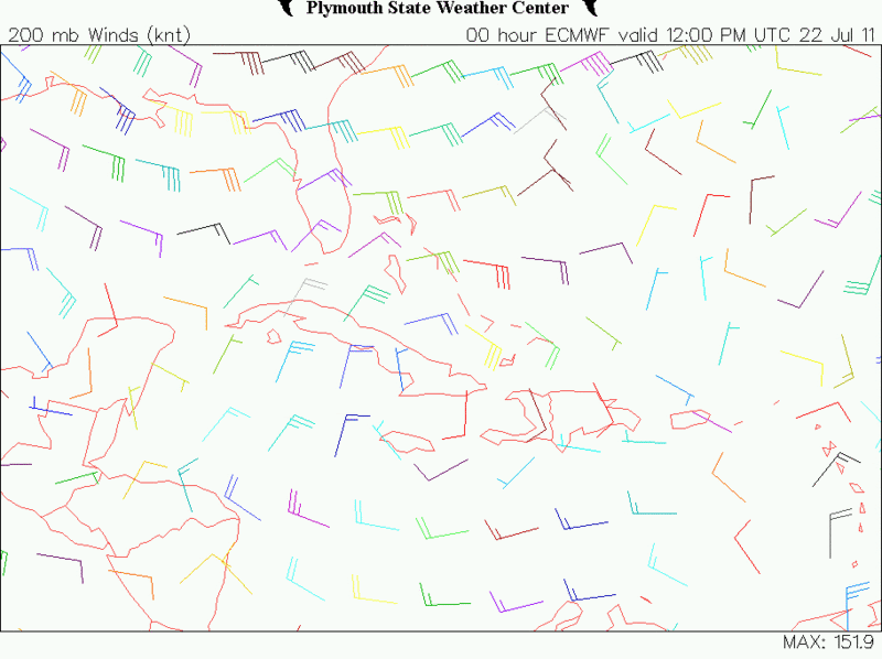
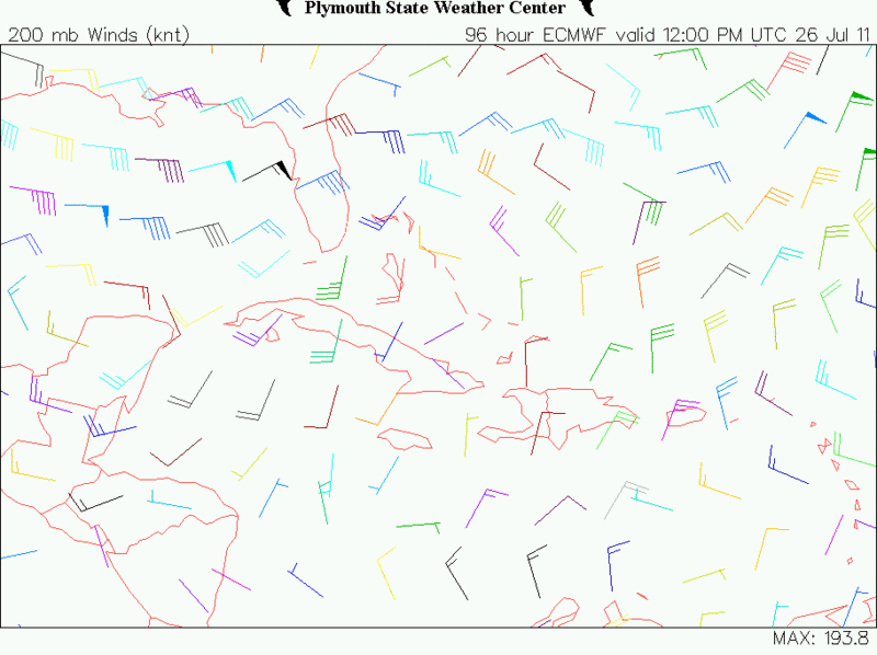
12z euro shows the ULL over Cuba to continue moving west with an UL ridge moving along with 90L.

Image
Image
0 likes   

BigB0882
S2K Supporter
S2K Supporter
Posts: 2284
Joined: Thu Jul 03, 2003 12:08 am
Location: Baton Rouge, LA
Contact:

#182 Postby BigB0882 » Fri Jul 22, 2011 4:42 pm

Looking better and better. Code orange, for sure.
0 likes   

User avatar
somethingfunny
ChatStaff
ChatStaff
Posts: 3926
Age: 37
Joined: Thu May 31, 2007 10:30 pm
Location: McKinney, Texas

#183 Postby somethingfunny » Fri Jul 22, 2011 4:43 pm

Days like these make every slow day since June 1st worth it. :D
0 likes   
I am not a meteorologist, and any posts made by me are not official forecasts or to be interpreted as being intelligent. These posts are just my opinions and are probably silly opinions.

User avatar
Ivanhater
Storm2k Moderator
Storm2k Moderator
Posts: 11160
Age: 38
Joined: Fri Jul 01, 2005 8:25 am
Location: Pensacola

Re: ATL: INVEST 90L - Discussion

#184 Postby Ivanhater » Fri Jul 22, 2011 4:48 pm

Once again, the models are horrible initializing this. Look at the 850 vorticity initialized on the 18z GFS compared to the actual 850 vort.


Image

Image
0 likes   
Michael

cpdaman
Category 5
Category 5
Posts: 3131
Joined: Sat Jun 10, 2006 11:44 am
Location: SPB county (gulf stream)

Re: ATL: INVEST 90L - Discussion

#185 Postby cpdaman » Fri Jul 22, 2011 4:49 pm

Will b back in s fl fri-mon. Fun to b Watching tropics again. When i lived down thete i was always happy to get to sept 21 without a cat 4/5 . The othets are dangerous yes...but the formers are "game over" scenarios and most likely mid aug to early /mid sept. Hope everyone is safe this year.
0 likes   

User avatar
KWT
Category 5
Category 5
Posts: 31415
Joined: Tue Aug 17, 2004 11:02 am
Location: UK!!!

#186 Postby KWT » Fri Jul 22, 2011 4:50 pm

Yep the statistical models are aggressive, the global models less so though from the looks of things...
0 likes   
Personal Forecast Disclaimer:
The posts in this forum are NOT official forecast and should not be used as such. They are just the opinion of the poster and may or may not be backed by sound meteorological data. They are NOT endorsed by any professional institution or storm2k.org. For official information, please refer to the NHC and NWS products

bamajammer4eva
Category 4
Category 4
Posts: 907
Joined: Sun Apr 18, 2010 3:21 am
Location: Ozark, AL

Re: ATL: INVEST 90L - Discussion

#187 Postby bamajammer4eva » Fri Jul 22, 2011 4:50 pm

vbhoutex wrote:
Blown Away wrote:
AREA FORECAST DISCUSSION...COR TO ADD PRELIM POPS AND TEMPS
NATIONAL WEATHER SERVICE MELBOURNE FL
308 PM EDT FRI JUL 22 2011

.PREVIOUS EXTENDED DISCUSSION...EARLY NEXT WEEK THE RIDGE OVER THE
STATE SHOWS BREAKING DUE TO FALLING HGHTS ACROSS THE CAROLINAS.
DEVELOPMENT OF A MEAN SFC TROUGH ALONG THE MID ATLC SEA BOARD WL ACT
TO TO INCREASE PCPN CHCS BY TUE AND CONTINUING THROUGH MIDWEEK WITH
DEVELOPMENT OF WLY STEERING LEVEL FLOW ALONG WITH LESS CONV
INHIBITION (COOLER TEMPS ALOFT AND MOISTURE). TROPICAL WV APCHG THE
BAHAMAS AROUND WED MAY HELP TO INCREASE MOISTURE LATE IN THE
WEEK...KEEPING AT LEAST SEASONAL PRECIP CHCS IN THE FCST.


Do these NWS offices just make their own call on tropical systems? Saying 90L will be approaching the Bahamas goes against almost all the models and the TAFB showing 90L moving as a wave through the Caribbean?? Brownsville NWS saying 90L going over Florida??? :lol:

They have as much or more divergence of opinion than this site does it seems. :eek: :lol:


I believe they go by their Interpretation of the models until the NHC classifies a system. I've even seen NWS Tallahassee forecast severe thunderstorms based on their WRF when the SPC didn't include our area in any risk at all.
0 likes   

User avatar
TropicalAnalystwx13
Category 5
Category 5
Posts: 2109
Age: 27
Joined: Tue Jul 19, 2011 8:20 pm
Location: Wilmington, NC
Contact:

#188 Postby TropicalAnalystwx13 » Fri Jul 22, 2011 4:54 pm

The ECMWF ASO forecast shows we are going to have some serious activity come August and on. May not get a break from constant storms until October.

Image
0 likes   

User avatar
TheBurn
Category 2
Category 2
Posts: 540
Joined: Thu Jul 28, 2005 4:00 pm
Location: Rincon, PR

Re: ATL: INVEST 90L - Discussion

#189 Postby TheBurn » Fri Jul 22, 2011 4:54 pm

Image
0 likes   

BigB0882
S2K Supporter
S2K Supporter
Posts: 2284
Joined: Thu Jul 03, 2003 12:08 am
Location: Baton Rouge, LA
Contact:

#190 Postby BigB0882 » Fri Jul 22, 2011 4:56 pm

My only worry is we are going to TX on the 28th and staying until the 3rd of August. I am not worried about a monster storm but I hate to leave my house and have a hurricane come and not know what is going on, especially with my cat being here. I do feel this has a slim chance of hitting my neck of the woods but you never know. As for being in TX, we will be well in land but with my luck it would come right to us and knock power out for a few days. :lol:
0 likes   

User avatar
somethingfunny
ChatStaff
ChatStaff
Posts: 3926
Age: 37
Joined: Thu May 31, 2007 10:30 pm
Location: McKinney, Texas

#191 Postby somethingfunny » Fri Jul 22, 2011 4:57 pm

The way the globals have been initializing this system, it's turning into one of those situations where you can only rely on the globals for upper level dynamics and not much else.
0 likes   
I am not a meteorologist, and any posts made by me are not official forecasts or to be interpreted as being intelligent. These posts are just my opinions and are probably silly opinions.

User avatar
Rgv20
S2K Supporter
S2K Supporter
Posts: 2466
Age: 38
Joined: Wed Jan 05, 2011 5:42 pm
Location: Edinburg/McAllen Tx

#192 Postby Rgv20 » Fri Jul 22, 2011 5:05 pm

NWS in Brownsville afternoon discussion regarding 90L

.LONG TERM /SUNDAY THROUGH FRIDAY/...THE SUMMER HEAT AND DROUGHT
PATTERN CONTINUES ON INTO THE LONG TERM PERIOD AS MID LEVEL RIDGING
REMAINS ENTRENCHED OVER MUCH OF THE LOWER 48 STATES. THIS WILL
MAINTAIN VERY ELEVATED 1000-500 MB THICKNESS VALUES ON THROUGH THE
FIRST HALF OF NEXT WEEK. LATER IN THE FORECAST PERIOD BOTH THE
ECMWF AND THE GFS INDICATE SOME WEAKENING IN THE OVERALL RIDGE
POSITION ON AND AFTER WEDNESDAY AS A PORTION OF THE 500 MB TROUGH
OVER THE EASTERN PORTIONS OF THE COUNTRY SPLITS OFF AND MOVES
AROUND THE SOUTHERN BASE OF THE RIDGE APPROACHING THE TX COASTLINE
ON OR AFTER WED. THIS WILL LIKELY DESTABILIZE THE ATMS OVER EITHER
OVER THE INLAND AREAS OR GULF WATERS. AT THIS TIME THE DEEPER
MOISTURE ASSOCIATED WITH THIS FEATURE REMAINS LOCATED TO THE NORTH
OF THE BRO CWA WHICH MAY LIMIT ANY OF THE CONV CHCS. SOME OF THE
BETTER MOISTURE VALUES MAY EDGE IN ENOUGH BY NEXT WEEKEND POSSIBLY
ALLOWING FOR SOME BETTER CHCS. BUT FOR NOW WILL MAINTAIN A DRY
FORECAST THROUGH NEXT FRI. LOOKING TOWARDS THE TROPICS NHC EXPECTS
A TROPICAL WAVE TO MOVE OVER FLORIDA AND THE SOUTHEASTERN GULF OF
MEX BY NEXT THURS EVENTUALLY PUSHING INTO THE SOUTH CENTRAL GULF
ON FRI. AT THIS TIME THIS FEATURE MAY BECOME MORE OF A CONCERN TO
THE TX COASTLINE NEXT WEEKEND. RESIDENTS OF DEEP SOUTH TEXAS SHOULD
CONTINUE TO MONITOR THE LATEST OUTLOOKS AND DISCUSSIONS FROM NHC
CONCERNING THE PROGRESS THIS FEATURE OVER THE NEXT SEVERAL DAYS
.
0 likes   
The following post is NOT an official forecast and should not be used as such. It is just the opinion of the poster and may or may not be backed by sound meteorological data. It is NOT endorsed by any professional institution including storm2k.org For Official Information please refer to the NHC and NWS products.

User avatar
KWT
Category 5
Category 5
Posts: 31415
Joined: Tue Aug 17, 2004 11:02 am
Location: UK!!!

Re:

#193 Postby KWT » Fri Jul 22, 2011 5:06 pm

BigB0882 wrote:Looking better and better. Code orange, for sure.


Yeah as many others have said it seems quite likely to me that they will up it to code orange. Does look better then it did yesterday.
0 likes   
Personal Forecast Disclaimer:
The posts in this forum are NOT official forecast and should not be used as such. They are just the opinion of the poster and may or may not be backed by sound meteorological data. They are NOT endorsed by any professional institution or storm2k.org. For official information, please refer to the NHC and NWS products

User avatar
cycloneye
Admin
Admin
Posts: 145286
Age: 68
Joined: Thu Oct 10, 2002 10:54 am
Location: San Juan, Puerto Rico

Re: ATL: INVEST 90L - Discussion

#194 Postby cycloneye » Fri Jul 22, 2011 5:23 pm

This is the Barbados pic site that shows a NNE direction winds in that island.

http://www.brohavwx.com/

Image

Uploaded by imageshack.us
0 likes   
Visit the Caribbean-Central America Weather Thread where you can find at first post web cams,radars
and observations from Caribbean basin members Click Here

User avatar
CourierPR
Category 5
Category 5
Posts: 1335
Age: 71
Joined: Tue Aug 31, 2004 7:53 pm
Location: Pompano Beach, Florida

Re:

#195 Postby CourierPR » Fri Jul 22, 2011 5:24 pm

[quote="TropicalAnalystwx13"]The ECMWF ASO forecast shows we are going to have some serious activity come August and on. May not get a break from constant storms until October.

Joe Bastardi tweeted similar thoughts today.
0 likes   

User avatar
HURAKAN
Professional-Met
Professional-Met
Posts: 46086
Age: 38
Joined: Thu May 20, 2004 4:34 pm
Location: Key West, FL
Contact:

Re: ATL: INVEST 90L - Discussion

#196 Postby HURAKAN » Fri Jul 22, 2011 5:26 pm

Image

drastic difference in the vorticity in the last 24 hours
0 likes   

BigB0882
S2K Supporter
S2K Supporter
Posts: 2284
Joined: Thu Jul 03, 2003 12:08 am
Location: Baton Rouge, LA
Contact:

#197 Postby BigB0882 » Fri Jul 22, 2011 5:29 pm

Even just this morning and early afternoon it was more of a light orange, now I can see the beginnings of some red in the center.
0 likes   

User avatar
KWT
Category 5
Category 5
Posts: 31415
Joined: Tue Aug 17, 2004 11:02 am
Location: UK!!!

#198 Postby KWT » Fri Jul 22, 2011 5:31 pm

Cool comparison image there Hurakan. You can also see the way it has tracked to the WNW in the last 24hrs as well, if that trend continues its probably heading just south of Hispaniola.
0 likes   
Personal Forecast Disclaimer:
The posts in this forum are NOT official forecast and should not be used as such. They are just the opinion of the poster and may or may not be backed by sound meteorological data. They are NOT endorsed by any professional institution or storm2k.org. For official information, please refer to the NHC and NWS products

chrisjslucia
S2K Supporter
S2K Supporter
Posts: 236
Joined: Thu Oct 09, 2008 8:27 pm
Location: St Lucia

Re: ATL: INVEST 90L - Discussion

#199 Postby chrisjslucia » Fri Jul 22, 2011 5:32 pm

Was hoping to have heard from someone in Barbados to get a real time description of 90L but no word yet. I was snoozing along assuming this was heading north of us and then looked at the Antilles radar and the rain is coming soon!

Having checked the radar for the past 30 minutes, it seems as the south western corner of the system is almost rolling to the South West, rather than heading due west. If so, St Vincent will get rain too.

Friends in the Leewards, take care.
0 likes   

User avatar
cycloneye
Admin
Admin
Posts: 145286
Age: 68
Joined: Thu Oct 10, 2002 10:54 am
Location: San Juan, Puerto Rico

Re: ATL: INVEST 90L - Discussion

#200 Postby cycloneye » Fri Jul 22, 2011 5:36 pm

chrisjslucia wrote:Was hoping to have heard from someone in Barbados to get a real time description of 90L but no word yet. I was snoozing along assuming this was heading north of us and then looked at the Antilles radar and the rain is coming soon!

Having checked the radar for the past 30 minutes, it seems as the south western corner of the system is almost rolling to the South West, rather than heading due west. If so, St Vincent will get rain too.

Friends in the Leewards, take care.


Good to see you my friend in St Lucia. Let's see if abajan comes and report from there what is going on. Stay safe and if you can,report from where you are the observations.
0 likes   
Visit the Caribbean-Central America Weather Thread where you can find at first post web cams,radars
and observations from Caribbean basin members Click Here


Return to “2011”

Who is online

Users browsing this forum: No registered users and 27 guests