Pouch 07L approaching Lesser Antilles - (Is invest 90L)
Moderator: S2k Moderators
Forum rules

The posts in this forum are NOT official forecasts and should not be used as such. They are just the opinion of the poster and may or may not be backed by sound meteorological data. They are NOT endorsed by any professional institution or STORM2K. For official information, please refer to products from the National Hurricane Center and National Weather Service.
-
Dean4Storms
- S2K Supporter

- Posts: 6358
- Age: 63
- Joined: Sun Aug 31, 2003 1:01 pm
- Location: Miramar Bch. FL
I believe this will make its way to the GOM based on the fact that it is doubtful it gains much latitude and hits the larger Carib. Islands which will keep the deepening and organization in check along with the fact it has a major need for moisture to overcome the drier air. Once in the Gulf it will all depend on the ridge and organization of this system.
0 likes
-
Rgv20

- S2K Supporter
- Posts: 2466
- Age: 39
- Joined: Wed Jan 05, 2011 5:42 pm
- Location: Edinburg/McAllen Tx
Re:
TreasureIslandFLGal wrote:Development has never really been a strong point of any of the models IMHO. However, once something starts to develop and the models are run specific to a system, they are get much better. The Euro has many lovers here, and I tend to follow it closely, though it often seems to turn things too quickly at first, due to overstrengthening and underestimating ridges. That's were the GFS can be a benefit, as it tends to see the ridge synoptics a bit better (at least in the past). I tend to look at the Euro, but take it with a grain of salt if the GFS is not in sync with its prognosis regarding where the High will be situated at the time a storm approaches its periphery. I tend to believe the GFS if they disagree on that point. But otherwise the Euro is generally more accurate in the other areas of projecting direction and to an extent, strength. Right now, none of the models are very good at that, as there are so many chaotic factors that influence strength. We are a few years away from them being able to incorporate them all. (shear, dust, land interaction, eye wall replacements, etc.) but that too is getitng better every year.
In my opinion the Euro is the best model on forecasting the large scale patterns in the medium and long ranges but one should never take literally the forecast of the models. But as you said with a blend of the ECMWF and GFS is the best way to try to forecast the weather.
Anyways getting back on topic the NWS in Brownsville made a brief comment on their afternoon discussion in regards to the Tropical Wave.
.LONG TERM /SATURDAY THROUGH THURSDAY/...UNFORTUNATELY THE SUMMER
HEAT AND DROUGHT CONDITIONS WITH BE THE MAIN FORECAST ISSUE ON
INTO THE LONG TERM PERIOD AS MID LEVEL RIDGING REMAINS ENTRENCHED
OVER MUCH OF THE LOWER 48 STATES. THIS WILL MAINTAIN VERY ELEVATED
1000-500 MB THICKNESS VALUES WELL INTO THE 580 TO 584 DAM RANGE
THROUGH DAY 7. THERE APPEARS TO BE A GLIMMER OF HOPE FOR SOME
WEAKENING IN THE OVERALL RIDGE POSITION LATE NEXT WEEK AS THE
PORTION OF THE EXPECTED 500 MB TROUGH OVER THE EASTERN PORTIONS OF
THE COUNTRY SPLITS OFF OF THE MAIN TROUGH AXIS AND PIVOTS AROUND
THE SOUTHERN SIDE OF THE RIDGE APPROACHING THE TX COASTLINE LATE
NEXT THURS OR FRI. THIS MAY HELP DESTABILIZE THE ATMS ENOUGH TO
ALLOW SOME AFTERNOON CONV TO FORM. HOWEVER AT THIS TIME THE DEEPER
MOISTURE ASSOCIATED WITH THIS FEATURE APPEARS WILL REMAIN LOCATED TO
THE NORTH OF THE BRO CWA WHICH MAY LIMIT ANY OF THE CONV CHCS. AT
THIS TIME WILL NOT MENTION ANY POPS OUT AT DAYS 6 AND 7 FOR THE
REGION. THE RUN TO RUN CONSISTENCY WITH THE GFS MEX TEMPS AND POPS
IS PRETTY GOOD AND MODEL TO MODEL AGREEMENT BETWEEN THE GFS AND
ECMWF IS ALSO PRETTY DECENT. SO OVERALL CONFIDENCE FOR THE LONGER
RANGE FORECAST IS ABOVE AVERAGE. THIS BEING SAID WILL GO A LITTLE
ABOVE MEX TEMP GUIDANCE FOR DAYS 3 THROUGH 7 AS THIS GUIDANCE HAS
APPEARED TO BE UNDERESTIMATING THE EXPECTED HIGHS A BIT. LOOKING
AT THE TROPICS NHC EXPECTS A BROAD TROPICAL WAVE TO MOVE OVER
FLORIDA AND THE EASTERN GULF OF MEX BY NEXT THURS. AT THIS TIME
THIS FEATURE DOES NOT POSE MUCH OF A CONCERN TO THE TX COASTLINE.
HOWEVER RESIDENTS OF DEEP SOUTH TEXAS SHOULD CONTINUE TO MONITOR
THE LATEST OUTLOOKS FROM NHC INTO NEXT WEEK.
0 likes
The following post is NOT an official forecast and should not be used as such. It is just the opinion of the poster and may or may not be backed by sound meteorological data. It is NOT endorsed by any professional institution including storm2k.org For Official Information please refer to the NHC and NWS products.
-
Jevo

- S2K Supporter
- Posts: 1729
- Age: 48
- Joined: Tue Aug 03, 2004 8:45 pm
- Location: The Flemish Cap
- Contact:
Re: Pouch PO7L east of Lesser Antilles - 10%
Whatever form our little friend is in.. It looks like he is going to sail right through the Hebert Box
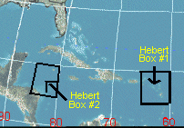
Explained for those that dont know what the Hebert Box is:
The Hebert Box was "discovered" in the late 1970s by Paul Hebert. This former NWS & NHC forecaster found many major Hurricanes that hit South Florida had to first pass through these boxes. The first box is located east of Puerto Rico and the second box is located over the Cayman Islands. Every Major Hurricane that passed through Box 2 late in the year, hit the Florida Peninsula prior to 1950. Hebert says that a Hurricane does not have to pass through these boxes to hit, but if they do "you better pay attention". The 1935 Labor day Hurricane that devastated the Florida Keys developed west of this box and Hurricane Andrew passed NE of this box, so there are exceptions to the rule.
If Floridians want an indication of a possible hit they need to keep an eye on any hurricane that passes through these boxes. Nearly every major Hurricane that hit S Florida since 1900 passed through these boxes. When major Hurricanes miss these boxes,they virtually always miss South Florida. If a major Hurricane moves into these boxes South Florida really needs to watch out. These boxes approx 335 miles x 335 miles includes the Virgin Islands but not Puerto Rico. The pattern has proven accurate for 9 out of 10 storms storms that developed & hit Dade,Broward & Palm Bch Counties
0 likes
Disclaimer: 50% of the time I have no clue of what I am talking about. Chances are I am taking a less than educated guess that sounds good because 10 years ago I stole Mike Watkins book 'The Hurricane and its Impact'. For official information please direct yourself to the NHC and their cadre of weather geniuses.
-
lonelymike
- S2K Supporter
- Posts: 634
- Joined: Sat Jul 26, 2008 10:12 am
- Location: walton county fla
Re: Pouch PO7L east of Lesser Antilles - 10%
At least its something to keep the board talking on for the next week or so.
0 likes
GO SEMINOLES
-
cycloneye

- Admin

- Posts: 149777
- Age: 69
- Joined: Thu Oct 10, 2002 10:54 am
- Location: San Juan, Puerto Rico
Re: Pouch PO7L east of Lesser Antilles - 10%
The update from the predict team for PO7L at 21:00 UTC continues to indicate a rather large moist envelope.

Uploaded by Imageshack.us
Uploaded by Imageshack.us
0 likes
Visit the Caribbean-Central America Weather Thread where you can find at first post web cams,radars
and observations from Caribbean basin members Click Here
and observations from Caribbean basin members Click Here
-
South Texas Storms

- Professional-Met

- Posts: 4263
- Joined: Thu Jun 24, 2010 12:28 am
- Location: Houston, TX
Re: Pouch PO7L east of Lesser Antilles - 10%
HURAKAN wrote:Tireman4 wrote:hurrican't wrote:first time poster, long time lurker here. i know its still way far out, but educated guess wise what do you guys think are the chances that this will hit the Texas gulf coast? thanks
I am not a meteorologist or play one on television, but I think (in my humble opinion) it is WAY too early for that thought. We have a long way to go and it has a long road to travel.
The posts in this forum are NOT official forecast and should not be used as such. They are just the opinion of the poster and may or may not be backed by sound meteorological data. They are NOT endorsed by any professional institution or storm2k.org. For official information, please refer to the NHC and NWS products.
I agree with Tireman4 here but we can still make 2 assumptions here.
1. If it organizes near the islands, it will likely recurve.
2. If it stays weak, it will likely move further westward and stay further south, which could pose a possible threat to the Gulf coast.
But it's just wait and see. My best wishes for Texas is a slow moving tropical storm!! Rain is badly needed!
I couldn't agree with you more HURAKAN. I'm really hope that this will only turn into a weak tropical storm that brings all of Texas some much needed rain!
0 likes
-
cycloneye
- Admin
- Posts: 149777
- Age: 69
- Joined: Thu Oct 10, 2002 10:54 am
- Location: San Juan, Puerto Rico
Re: Pouch PO7L east of Lesser Antilles - 10%
Remains at 10%
TROPICAL WEATHER OUTLOOK
NWS NATIONAL HURRICANE CENTER MIAMI FL
800 PM EDT THU JUL 21 2011
FOR THE NORTH ATLANTIC...CARIBBEAN SEA AND THE GULF OF MEXICO...
THE NATIONAL HURRICANE CENTER IS ISSUING ADVISORIES ON TROPICAL
STORM CINDY...LOCATED ABOUT 995 MILES WEST-NORTHWEST OF THE
AZORES. ADVISORIES ARE ALSO BEING ISSUED ON TROPICAL STORM
BRET...LOCATED ABOUT 335 MILES EAST OF CAPE HATTERAS NORTH CAROLINA.
A TROPICAL WAVE LOCATED ABOUT 650 MILES EAST OF THE WINDWARD ISLANDS
IS PRODUCING LIMITED AND DISORGANIZED SHOWER AND THUNDERSTORM
ACTIVITY. SOME SLOW DEVELOPMENT OF THIS SYSTEM IS POSSIBLE DURING
THE NEXT COUPLE OF DAYS AS IT MOVES TOWARD THE WEST-NORTHWEST AT 15
TO 20 MPH. THIS SYSTEM HAS A LOW CHANCE...10 PERCENT...OF BECOMING
A TROPICAL CYCLONE DURING THE NEXT 48 HOURS. SHOWERS ASSOCIATED
WITH THIS WAVE COULD BEGIN SPREADING ACROSS PORTIONS OF THE LESSER
ANTILLES ON FRIDAY.
ELSEWHERE...TROPICAL CYCLONE FORMATION IS NOT EXPECTED DURING THE
NEXT 48 HOURS.
$$
FORECASTER BERG
0 likes
Visit the Caribbean-Central America Weather Thread where you can find at first post web cams,radars
and observations from Caribbean basin members Click Here
and observations from Caribbean basin members Click Here
-
Rgv20
- S2K Supporter
- Posts: 2466
- Age: 39
- Joined: Wed Jan 05, 2011 5:42 pm
- Location: Edinburg/McAllen Tx
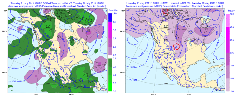
12zECMWF Ensembles still trying to hint at some development just north of Cuba.
0 likes
The following post is NOT an official forecast and should not be used as such. It is just the opinion of the poster and may or may not be backed by sound meteorological data. It is NOT endorsed by any professional institution including storm2k.org For Official Information please refer to the NHC and NWS products.

Re: Pouch PO7L east of Lesser Antilles - 10%
18z NOGAPs staying consistent - into SC.
https://www.fnmoc.navy.mil/wxmap_cgi/cgi-bin/wxmap_loop.cgi?&area=ngp_troplant&prod=prp&dtg=2011072118&set=Tropical
https://www.fnmoc.navy.mil/wxmap_cgi/cgi-bin/wxmap_loop.cgi?&area=ngp_troplant&prod=prp&dtg=2011072118&set=Tropical
0 likes
-
plasticup
Re: Pouch PO7L east of Lesser Antilles - 10%
I am positive that we are going to see something out of this. The only question is when and where. Early and up to Atlantic coat? Or late and into Florida et al? Whichever way it goes, next week is going to be very interesting.
Btw, a little factoid from the Cindy thread: America has not had a technical landfall in 20 consecutive storms. That's a record which I suspect The Don will put to rest.
ps, doesn't Don sound ominous?
Btw, a little factoid from the Cindy thread: America has not had a technical landfall in 20 consecutive storms. That's a record which I suspect The Don will put to rest.
ps, doesn't Don sound ominous?
0 likes
-
Gustywind

- Category 5

- Posts: 12334
- Joined: Mon Sep 03, 2007 7:29 am
- Location: Baie-Mahault, GUADELOUPE
000
AXNT20 KNHC 212343
TWDAT
TROPICAL WEATHER DISCUSSION
NWS NATIONAL HURRICANE CENTER MIAMI FL
805 PM EDT THU JUL 21 2011
TROPICAL WEATHER DISCUSSION FOR NORTH AMERICA...CENTRAL
AMERICA...GULF OF MEXICO...CARIBBEAN SEA...NORTHERN SECTIONS
OF SOUTH AMERICA...AND ATLANTIC OCEAN TO THE AFRICAN COAST
FROM THE EQUATOR TO 32N. THE FOLLOWING INFORMATION IS BASED
ON SATELLITE IMAGERY...WEATHER OBSERVATIONS...RADAR...AND
METEOROLOGICAL ANALYSIS.
BASED ON 1800 UTC SURFACE ANALYSIS AND SATELLITE IMAGERY
THROUGH 2300 UTC.
...TROPICAL WAVES...
TROPICAL WAVE EXTENDS E OF THE WINDWARD ISLANDS ALONG 17N49W
11N52W 7N52W MOVING W NEAR 20 KT. SATELLITE IMAGERY INDICATES
BROAD CYCLONIC FLOW IS AROUND THE WAVE AXIS. TOTAL PRECIPITABLE
WATER IMAGERY ALSO SHOWS A SURGE OF DEEP LAYER MOISTURE IS
AROUND THE AXIS. SCATTERED MODERATE/ISOLATED STRONG CONVECTION
IS FROM 12N-19N BETWEEN 46W-53W.
...DISCUSSION...
CARIBBEAN SEA...
AA TROPICAL WAVE E OF THE WINDWARD ISLANDS WILL
PROBABLY BEGIN IMPACTING THE ISLANDS WITHIN THE NEXT 24 HRS
BRINGING SHOWERS/THUNDERSTORMS...SOME HEAVY AT TIMES.
$$
WALTON
0 likes
-
cycloneye
- Admin
- Posts: 149777
- Age: 69
- Joined: Thu Oct 10, 2002 10:54 am
- Location: San Juan, Puerto Rico
Re: Pouch PO7L east of Lesser Antilles - 10%
The recent ASCAT shows anything impressive tonight on the windfield.

Uploaded by Imageshack.us
Uploaded by Imageshack.us
0 likes
Visit the Caribbean-Central America Weather Thread where you can find at first post web cams,radars
and observations from Caribbean basin members Click Here
and observations from Caribbean basin members Click Here

popcorn convection beginning to fire...stage one...As it continues towrd 55w the convection will beome more organized and concentrated by morning...May take a few more days to reach the surface..Regardless very squally weather for the leser antilles and PR this weekend..Pressure graidient may allow for gusts to TS as it passes thru the region even if it doesnt get designated a TD/storm until passing over the islands or PR...
0 likes


-
cycloneye
- Admin
- Posts: 149777
- Age: 69
- Joined: Thu Oct 10, 2002 10:54 am
- Location: San Juan, Puerto Rico
Re: Pouch PO7L east of Lesser Antilles - 10%
The leading edge of the wave is now on the Barbados pic range.
http://www.brohavwx.com/

Uploaded by Imageshack.us
http://www.brohavwx.com/
Uploaded by Imageshack.us
0 likes
Visit the Caribbean-Central America Weather Thread where you can find at first post web cams,radars
and observations from Caribbean basin members Click Here
and observations from Caribbean basin members Click Here

Re: Pouch PO7L east of Lesser Antilles - 10%
The firing of convection ahead of the wave may indicate that the air in front of it is slowly getting less dry. I'm honestly not sure.
0 likes
-
gatorcane

- S2K Supporter
- Posts: 23708
- Age: 48
- Joined: Sun Mar 13, 2005 3:54 pm
- Location: Boca Raton, FL
The posts in this forum are NOT official forecast and should not be used as such. They are just the opinion of the poster and may or may not be backed by sound meteorological data. They are NOT endorsed by any professional institution or storm2k.org. For official information, please refer to the NHC and NWS products.
Convection has died off this evening. So far it is behaving as I expected. Pulsing convection that flares up and down as it moves towards the Caribbean Sea. Still going with the GFS solution.....which doesn't call for any significant development.
Of course will continue to monitor the situation each day and provide feedback.
Lot's of dry air around:
Last edited by gatorcane on Thu Jul 21, 2011 9:42 pm, edited 2 times in total.
0 likes

Re: Pouch PO7L east of Lesser Antilles - 10%
This tropical wave seems to consolidating as it gets into very warmer waters, and may become at least a TD as it passes through the islands .
0 likes
Who is online
Users browsing this forum: No registered users and 195 guests