
18z NOGAPs takes it on a Hugo-like track.
https://www.fnmoc.navy.mil/wxmap_cgi/cgi-bin/wxmap_loop.cgi?&area=ngp_troplant&prod=prp&dtg=2011072018&set=Tropical
Pouch 07L approaching Lesser Antilles - (Is invest 90L)
Moderator: S2k Moderators
Forum rules

The posts in this forum are NOT official forecasts and should not be used as such. They are just the opinion of the poster and may or may not be backed by sound meteorological data. They are NOT endorsed by any professional institution or STORM2K. For official information, please refer to products from the National Hurricane Center and National Weather Service.
-
cycloneye

- Admin

- Posts: 149781
- Age: 69
- Joined: Thu Oct 10, 2002 10:54 am
- Location: San Juan, Puerto Rico
Re: Wave in C Atlantic is Pouch PO7L - Develops down the road?
8 PM TWD:
TROPICAL WAVE IS ANALYZED FROM 07N46W TO 16N40W MOVING W AT 20
KT. THE WAVE IS LOCATED ON THE LEADING EDGE OF A RATHER LARGE
AND BROAD AREA OF LOW-LEVEL MOISTURE TO THE EAST OF THE WAVE
AXIS AS NOTED ON TOTAL PRECIPITABLE WATER IMAGERY. THIS ALONG
WITH OVERALL BROAD CYCLONIC FLOW S OF 15N BETWEEN 35W-48W
ACCOMPANY THE WAVE WHICH CONTINUES TO PERTURB THE ITCZ AXIS.
ISOLATED MODERATE CONVECTION IS WITHIN 90 NM WEST OF THE WAVE N
OF 12N.
0 likes
Visit the Caribbean-Central America Weather Thread where you can find at first post web cams,radars
and observations from Caribbean basin members Click Here
and observations from Caribbean basin members Click Here

I'd still personally punt on no development unless it can get deep either into the Gulf or into the W.Caribbean/BoC...then obviously that maybe a different ballgame.
It does look good though, I'd very sure if this was in mid August we'd have a player, in mid July, its maybe just a little too soon still.
It does look good though, I'd very sure if this was in mid August we'd have a player, in mid July, its maybe just a little too soon still.
0 likes
Personal Forecast Disclaimer:
The posts in this forum are NOT official forecast and should not be used as such. They are just the opinion of the poster and may or may not be backed by sound meteorological data. They are NOT endorsed by any professional institution or storm2k.org. For official information, please refer to the NHC and NWS products
The posts in this forum are NOT official forecast and should not be used as such. They are just the opinion of the poster and may or may not be backed by sound meteorological data. They are NOT endorsed by any professional institution or storm2k.org. For official information, please refer to the NHC and NWS products
-
SouthFLTropics

- Category 5

- Posts: 4258
- Age: 50
- Joined: Thu Aug 14, 2003 8:04 am
- Location: Port St. Lucie, Florida
Re: Wave in C Atlantic is Pouch PO7L - Develops down the road?
If that Nogaps run panned out and the ridge were to build back in it could mean we could possibly see the long feared Jacksonville or Savannah storm. Good thing right now it is pure fantasy land that far out.
SFT
SFT
0 likes
Fourth Generation Florida Native
Personal Storm History: David 79, Andrew 92, Erin 95, Floyd 99, Irene 99, Frances 04, Jeanne 04, Wilma 05, Matthew 16, Irma 17, Ian 22, Nicole 22, Milton 24
Personal Storm History: David 79, Andrew 92, Erin 95, Floyd 99, Irene 99, Frances 04, Jeanne 04, Wilma 05, Matthew 16, Irma 17, Ian 22, Nicole 22, Milton 24
-
lonelymike
- S2K Supporter

- Posts: 634
- Joined: Sat Jul 26, 2008 10:12 am
- Location: walton county fla
Re: Wave in C Atlantic is Pouch PO7L - Develops down the road?
Might be a nice rainmaker for TX. Though it'll probably go into Mexico with the Deathridge overhead the gulf states.
0 likes
GO SEMINOLES
-
South Texas Storms

- Professional-Met

- Posts: 4263
- Joined: Thu Jun 24, 2010 12:28 am
- Location: Houston, TX
Re: Wave in C Atlantic is Pouch PO7L - Develops down the road?
lonelymike wrote:Might be a nice rainmaker for TX. Though it'll probably go into Mexico with the Deathridge overhead the gulf states.
That's exactly what I'm hoping for. A lot of rain for all of Texas and hopefully not too much wind. It looks like we are going to be tracking this for a while.
0 likes

Re: Wave in C Atlantic is Pouch PO7L - Develops down the road?
South Texas Storms wrote:lonelymike wrote:Might be a nice rainmaker for TX. Though it'll probably go into Mexico with the Deathridge overhead the gulf states.
That's exactly what I'm hoping for. A lot of rain for all of Texas and hopefully not too much wind. It looks like we are going to be tracking this for a while.
Models show it around the Puerto Rico area by Saturday. Thats about 8-10 from Texas on a medium pace..
0 likes
-
Jevo

- S2K Supporter
- Posts: 1729
- Age: 48
- Joined: Tue Aug 03, 2004 8:45 pm
- Location: The Flemish Cap
- Contact:
Re: Wave in C Atlantic is Pouch PO7L - Develops down the road?
Well with all of the models hitting on something coming out of this area.. I would say this it's right about that time
This system

This system
0 likes
Disclaimer: 50% of the time I have no clue of what I am talking about. Chances are I am taking a less than educated guess that sounds good because 10 years ago I stole Mike Watkins book 'The Hurricane and its Impact'. For official information please direct yourself to the NHC and their cadre of weather geniuses.
-
Blown Away

- S2K Supporter
- Posts: 10253
- Joined: Wed May 26, 2004 6:17 am
Re: Wave in C Atlantic is Pouch PO7L - Develops down the road?
There is so much dry/dust air in front of this wave, but it keeps moistening as it goes. Convection is not impressive at all, but it has consolidated more compared to this morning. Still think development chances are low, but as long as there is model support I'll be watching.
0 likes
Hurricane Eye Experience: David 79, Irene 99, Frances 04, Jeanne 04, Wilma 05… Hurricane Brush Experience: Andrew 92, Erin 95, Floyd 99, Matthew 16, Irma 17, Ian 22, Nicole 22…
-
gatorcane

- S2K Supporter
- Posts: 23708
- Age: 48
- Joined: Sun Mar 13, 2005 3:54 pm
- Location: Boca Raton, FL
The posts in this forum are NOT official forecast and should not be used as such. They are just the opinion of the poster and may or may not be backed by sound meteorological data. They are NOT endorsed by any professional institution or storm2k.org. For official information, please refer to the NHC and NWS products.
I am going with the GFS solution at this point which brings this wave into the Caribbean with no significant development. Could be a player once it makes it into the Western Caribbean area though...I expect this wave to flare up and down though as it moves west.
I can't see how this will not miss the Caribbean as it is shallow and ridging is driving it West, maybe even a tad south of due west.
Link to 18Z GFS:
http://moe.met.fsu.edu/cgi-bin/gfstc2.c ... =Animation
0 likes
-
Blown Away
- S2K Supporter
- Posts: 10253
- Joined: Wed May 26, 2004 6:17 am
Re:
gatorcane wrote:The posts in this forum are NOT official forecast and should not be used as such. They are just the opinion of the poster and may or may not be backed by sound meteorological data. They are NOT endorsed by any professional institution or storm2k.org. For official information, please refer to the NHC and NWS products.
I am going with the GFS solution at this point which brings this wave into the Caribbean with no significant development. Could be a player once it makes it into the Western Caribbean area though...I expect this wave to flare up and down though as it moves west.
I can't see how this will not miss the Caribbean as it is shallow and ridging is driving it West, maybe even a tad south of due west.
Link to 18Z GFS:
http://moe.met.fsu.edu/cgi-bin/gfstc2.c ... =Animation
No development is most likely, but if we get an LLC IMO it will come from the area around 14N/45W, which is moving W.
0 likes
Hurricane Eye Experience: David 79, Irene 99, Frances 04, Jeanne 04, Wilma 05… Hurricane Brush Experience: Andrew 92, Erin 95, Floyd 99, Matthew 16, Irma 17, Ian 22, Nicole 22…
-
HurricaneFan
- Tropical Storm

- Posts: 192
- Age: 42
- Joined: Tue Jan 18, 2011 6:16 pm
- Location: Anguilla,Leeward Islands 18.3N 63.0W
-
tolakram
- Admin
- Posts: 20187
- Age: 62
- Joined: Sun Aug 27, 2006 8:23 pm
- Location: Florence, KY (name is Mark)
Re: Wave in C Atlantic is Pouch PO7L - Develops down the road?
Loop: http://wwwghcc.msfc.nasa.gov/cgi-bin/ge ... =spect.pal
Convection is a bit on the increase, but a long long way before it's even a worry.
Convection is a bit on the increase, but a long long way before it's even a worry.
0 likes
M a r k
- - - - -
Join us in chat: Storm2K Chatroom Invite. Android and IOS apps also available.
The posts in this forum are NOT official forecasts and should not be used as such. Posts are NOT endorsed by any professional institution or STORM2K.org. For official information and forecasts, please refer to NHC and NWS products.
-
South Texas Storms
- Professional-Met
- Posts: 4263
- Joined: Thu Jun 24, 2010 12:28 am
- Location: Houston, TX
Re: Wave in C Atlantic is Pouch PO7L - Develops down the road?
I think it is maintaining itself pretty well right now. It will be interesting to see what the 0z models show in a few hours.
0 likes
-
Blown Away
- S2K Supporter
- Posts: 10253
- Joined: Wed May 26, 2004 6:17 am
Re: Wave in C Atlantic is Pouch PO7L - Develops down the road?
Joe Bastardi Twitter:
Tropical wave in central atlantic near PR sat, Bahamas after. Potential threat Fla, then perhaps gulf after. It has the look of trouble
0 likes
Hurricane Eye Experience: David 79, Irene 99, Frances 04, Jeanne 04, Wilma 05… Hurricane Brush Experience: Andrew 92, Erin 95, Floyd 99, Matthew 16, Irma 17, Ian 22, Nicole 22…
-
Rgv20

- S2K Supporter
- Posts: 2466
- Age: 39
- Joined: Wed Jan 05, 2011 5:42 pm
- Location: Edinburg/McAllen Tx
Assuming this thing develops and the trough does not pick it up it has no where to go but west. This looks to be a trouble maker for the Gulf.
12zECMWF(Left)&GFS(Right) 500mb anomalies from 12zWed July 27 to Saturday July 30.
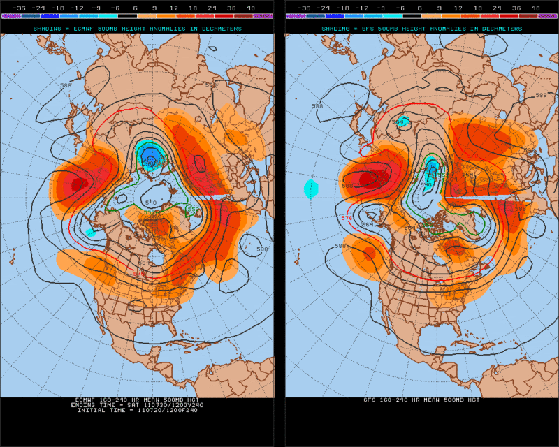
12zECMWF Ensembles at the 240hr, its very interesting that they are showing a lowering of 500mb heights right in the middle of the GOM. This just means that some of the Ensemble members are showing potential trouble brewing in the GOM.
12zECMWF(Left)&GFS(Right) 500mb anomalies from 12zWed July 27 to Saturday July 30.
12zECMWF Ensembles at the 240hr, its very interesting that they are showing a lowering of 500mb heights right in the middle of the GOM. This just means that some of the Ensemble members are showing potential trouble brewing in the GOM.
0 likes
The following post is NOT an official forecast and should not be used as such. It is just the opinion of the poster and may or may not be backed by sound meteorological data. It is NOT endorsed by any professional institution including storm2k.org For Official Information please refer to the NHC and NWS products.

Re: Wave in C Atlantic is Pouch PO7L - Develops down the road?
it is booking it west at a good clip and at a low lat....unless it consolidates further north my bet is carib bound for now...doesnt look good attm...
0 likes
-
Ivanhater

- Storm2k Moderator

- Posts: 11222
- Age: 39
- Joined: Fri Jul 01, 2005 8:25 am
- Location: Pensacola
Re: Wave in C Atlantic is Pouch PO7L - Develops down the road?
ROCK wrote:it is booking it west at a good clip and at a low lat....unless it consolidates further north my bet is carib bound for now...doesnt look good attm...
Development will not take place until getting around the Islands at the earliest. With a signature like this, development looks good imo.

0 likes
Michael
Re: Wave in C Atlantic is Pouch PO7L - Develops down the road?
Ivanhater wrote:ROCK wrote:it is booking it west at a good clip and at a low lat....unless it consolidates further north my bet is carib bound for now...doesnt look good attm...
Development will not take place until getting around the Islands at the earliest. With a signature like this, development looks good imo.
I agree....development is likely but with models all over the place I am not sure where that might be. Carib or above the islands...or even thru the islands..sorry Luis...
0 likes
-
Ivanhater
- Storm2k Moderator
- Posts: 11222
- Age: 39
- Joined: Fri Jul 01, 2005 8:25 am
- Location: Pensacola
Re: Wave in C Atlantic is Pouch PO7L - Develops down the road?
Lol Rock...the lid has blown off, a bit earlier than even I thought. The models never saw Bret or Cindy either..gotta love the models. My 'ol pal the Canadian likes this disturbance so I like it as well 
0 likes
Michael