
000
URNT15 KNHC 172232
AF304 01BBA INVEST HDOB 41 20110717
222230 2754N 07938W 6453 03875 //// +045 //// 348021 022 018 000 01
222300 2754N 07940W 6465 03859 //// +043 //// 346021 021 020 000 05
222330 2753N 07943W 6461 03864 //// +042 //// 345021 021 018 001 01
222400 2753N 07945W 6461 03863 //// +040 //// 345020 020 019 000 01
222430 2753N 07948W 6463 03859 //// +040 //// 344020 020 015 001 01
222500 2752N 07950W 6470 03855 //// +040 //// 341019 019 015 001 01
222530 2752N 07953W 6463 03866 //// +039 //// 343019 020 014 001 05
222600 2751N 07955W 6348 04011 //// +033 //// 354020 021 013 000 01
222630 2751N 07958W 6198 04208 //// +022 //// 012022 024 010 000 01
222700 2751N 08000W 6055 04396 //// +011 //// 020022 024 006 000 01
222730 2750N 08003W 5913 04557 //// +004 //// 025019 020 001 001 05
222800 2750N 08005W 5666 04897 //// -013 //// 032021 021 /// /// 05
222830 2749N 08008W 5431 05255 0296 -030 //// 033021 021 /// /// 05
222900 2749N 08010W 5263 05504 0311 -048 //// 035023 024 /// /// 05
222930 2749N 08013W 5101 05752 0324 -058 //// 027022 022 /// /// 05
223000 2748N 08015W 4944 05991 0338 -074 //// 022019 020 /// /// 05
223030 2748N 08018W 4803 06226 0353 -088 //// 018018 018 /// /// 05
223100 2747N 08020W 4673 06430 0365 -106 //// 007017 018 /// /// 05
223130 2747N 08023W 4555 06625 0370 -121 //// 007015 016 000 000 05
223200 2747N 08025W 4457 06756 0354 -123 //// 018019 021 /// /// 05
$$
;
ATL: BRET - Remnants - Discussion
Moderator: S2k Moderators


Re: ATL: TWO - Tropical Depression - Discussion
Yay, it's pouring in the Upper Keys, though not really from TD2, just the late-day convection dropping down from the mainland. Indicates some weak southerly steering over the mainland though.
0 likes
000
URNT15 KNHC 172242
AF304 01BBA INVEST HDOB 42 20110717
223230 2746N 08028W 4377 06895 0356 -124 //// 019021 022 /// /// 05
223300 2746N 08030W 4273 07075 0363 -136 //// 020018 018 /// /// 05
223330 2745N 08033W 4184 07252 0385 -146 //// 013019 019 /// /// 05
223400 2745N 08036W 4094 07399 0378 -159 //// 008015 016 /// /// 05
223430 2744N 08038W 4009 07588 0417 -166 //// 352015 016 /// /// 05
223500 2744N 08038W 4009 07588 0427 -173 //// 342013 013 /// /// 05
223530 2744N 08043W 3851 07887 0437 -181 //// 336014 014 /// /// 05
223600 2743N 08046W 3801 07985 0444 -186 //// 342013 013 /// /// 05
223630 2743N 08049W 3744 08100 0451 -194 //// 342012 013 /// /// 05
223700 2742N 08051W 3690 08207 0459 -205 //// 340012 013 /// /// 05
223730 2742N 08054W 3634 08321 0466 -215 //// 336013 013 /// /// 05
223800 2741N 08057W 3602 08388 0473 -220 //// 330014 014 /// /// 05
223830 2741N 08059W 3591 08410 0474 -225 //// 329014 014 /// /// 05
223900 2740N 08102W 3598 08400 0475 -222 //// 335013 014 /// /// 05
223930 2740N 08105W 3597 08402 0475 -220 //// 335015 015 /// /// 05
224000 2739N 08108W 3597 08403 0475 -220 //// 334015 015 /// /// 05
224030 2739N 08111W 3598 08402 0476 -221 //// 333014 015 /// /// 05
224100 2738N 08114W 3598 08400 0478 -225 //// 335014 014 /// /// 05
224130 2738N 08117W 3597 08408 0479 -225 //// 333014 015 /// /// 05
224200 2737N 08120W 3597 08408 0480 -223 //// 325015 015 /// /// 05
$$
0 likes

Re: ATL: TWO - Recon
Thanks for the welcome artist, glad to be of help! It does look like they're finished (for now anyway  ). I'm going to grab some dinner myself.
0 likes
- Disclaimer: Posts herein are my amateur opinion only and should not be used for making important decisions. Defer to the NHC, NWS, and local authorities for official guidance.
-
brunota2003

- S2K Supporter

- Posts: 9476
- Age: 35
- Joined: Sat Jul 30, 2005 9:56 pm
- Location: Stanton, KY...formerly Havelock, NC
- Contact:

Thats probavbly the case, the wind shift and the way the pressure dropped quite a bit near the center suggests the core is quite small though pretty strong.
Interestingly the ECM did spot this system a good 5 days ago, here is a post I made early on the 12th of July:
"The 0z ECM does try and develop something very close to the coast off Carlolina...a further 50-100 mile eastward shunt and it'd probably develop into a TD/TS as it tries to cut-off from the front..."
A little too far north but the ECM didn't make a bad call there actually in the end!
0 likes
Personal Forecast Disclaimer:
The posts in this forum are NOT official forecast and should not be used as such. They are just the opinion of the poster and may or may not be backed by sound meteorological data. They are NOT endorsed by any professional institution or storm2k.org. For official information, please refer to the NHC and NWS products
The posts in this forum are NOT official forecast and should not be used as such. They are just the opinion of the poster and may or may not be backed by sound meteorological data. They are NOT endorsed by any professional institution or storm2k.org. For official information, please refer to the NHC and NWS products
-
SouthDadeFish

- Professional-Met

- Posts: 2835
- Joined: Thu Sep 23, 2010 2:54 pm
- Location: Miami, FL
- Contact:
Thanks GCANE. I knew the effects of an anticyclone, just wondering your personal forecast as you always have unique analysis on things. I'm not too sold it will travel far enough west to feel the effects of a possible MCS anticyclone. It seems to be drifting SE already. I think the NHC has a very reasonable forecast for TD 2/ Bret.
0 likes
Yeah sounds like a decent call to me as SDF, as much as I've been bashing the current estimated strength, I see nothing in that forecast that looks out of place at all...maybe the estimated top strength is overdone?
Who knows!
Who knows!
0 likes
Personal Forecast Disclaimer:
The posts in this forum are NOT official forecast and should not be used as such. They are just the opinion of the poster and may or may not be backed by sound meteorological data. They are NOT endorsed by any professional institution or storm2k.org. For official information, please refer to the NHC and NWS products
The posts in this forum are NOT official forecast and should not be used as such. They are just the opinion of the poster and may or may not be backed by sound meteorological data. They are NOT endorsed by any professional institution or storm2k.org. For official information, please refer to the NHC and NWS products
-
ozonepete
- Professional-Met
- Posts: 4743
- Joined: Mon Sep 07, 2009 3:23 pm
- Location: From Ozone Park, NYC / Now in Brooklyn, NY
Re: ATL: TWO - Tropical Depression - Discussion
Recurve wrote:Yay, it's pouring in the Upper Keys, though not really from TD2, just the late-day convection dropping down from the mainland. Indicates some weak southerly steering over the mainland though.
That big line of thunderstorms over south and southwestern Florida is a result of the northerly flow from TD2 colliding with the mesoscale seabreeze front. Really good news for you guys - you get heavy rain without damaging winds.
0 likes


Re: ATL: TWO - Tropical Depression - Discussion
This is kind of a surprise for me, when I looked at it this morning I thought it was going to develop but in the previous days I thought it had very little chances as the models were not doing anything with it. It seem that convection is increasing near the center isn't it?
0 likes
-
stormreader
Re: ATL: TWO - Tropical Depression - Discussion
Well we have a tropical cyclone. However, I feel sort of guiltyat not having more of a postive attitude about the importance or status of this system. I enjoy tracking storms and will do the same with this one. But I must admit I'm not very impressed. It looks like this might only be a blip along the long trough line and acompanying upper level shear extending from Florida east into the open Atlantic. But maybe it will surprise.
http://www.ssd.noaa.gov/goes/east/tatl/flash-wv.html
http://www.ssd.noaa.gov/goes/east/tatl/flash-wv.html
0 likes

Re: ATL: TWO - Tropical Depression - Discussion
G cane, what largely populated area are you referring to?
It looks like it's headed n/ne like those storms did last year. Same pattern?
It looks like it's headed n/ne like those storms did last year. Same pattern?
0 likes

-
Blown Away

- S2K Supporter
- Posts: 10253
- Joined: Wed May 26, 2004 6:17 am
Re: ATL: TWO - Tropical Depression - Discussion
TD2 is interesting because it appeared out of clear blue sky, no models hinted the development, I love that! Sorry, I'm ready for some real storms chugging across the Atlantic.
0 likes
Hurricane Eye Experience: David 79, Irene 99, Frances 04, Jeanne 04, Wilma 05… Hurricane Brush Experience: Andrew 92, Erin 95, Floyd 99, Matthew 16, Irma 17, Ian 22, Nicole 22…


-
cycloneye

- Admin

- Posts: 149431
- Age: 69
- Joined: Thu Oct 10, 2002 10:54 am
- Location: San Juan, Puerto Rico
Re: ATL: TWO - Advisories
BRET!
TTAA00 KNHC DDHHMM
BULLETIN
TROPICAL STORM BRET INTERMEDIATE ADVISORY NUMBER 1A
NWS NATIONAL HURRICANE CENTER MIAMI FL AL022011
800 PM EDT SUN JUL 17 2011
...TROPICAL DEPRESSION STRENGTHENS...BECOMES THE SECOND TROPICAL
STORM OF THE 2011 ATLANTIC HURRICANE SEASON...
SUMMARY OF 800 PM EDT...0000 UTC...INFORMATION
----------------------------------------------
LOCATION...27.5N 78.1W
ABOUT 100 MI...165 KM NW OF GREAT ABACO ISLAND
MAXIMUM SUSTAINED WINDS...40 MPH...65 KM/H
PRESENT MOVEMENT...SSE OR 145 DEGREES AT 2 MPH...4 KM/H
MINIMUM CENTRAL PRESSURE...1009 MB...29.80 INCHES
WATCHES AND WARNINGS
--------------------
CHANGES WITH THIS ADVISORY...
NONE
SUMMARY OF WATCHES AND WARNINGS IN EFFECT...
A TROPICAL STORM WATCH IS IN EFFECT FOR...
* GRAND BAHAMA ISLAND AND THE ABACO ISLANDS IN THE NORTHWEST BAHAMAS
FOR STORM INFORMATION SPECIFIC TO YOUR AREA...PLEASE MONITOR
PRODUCTS ISSUED BY YOUR NATIONAL METEOROLOGICAL SERVICE.
DISCUSSION AND 48-HOUR OUTLOOK
------------------------------
AT 800 PM EDT...0000 UTC...THE CENTER OF TROPICAL STORM BRET WAS
LOCATED NEAR LATITUDE 27.5 NORTH...LONGITUDE 78.1 WEST. BRET IS
DRIFTING TOWARD THE SOUTH-SOUTHEAST NEAR 2 MPH...4 KM/H...AND
LITTLE MOVEMENT IS EXPECTED OVERNIGHT...FOLLOWED BY A SLOW NORTH-
NORTHEASTWARD MOTION ON MONDAY.
MAXIMUM SUSTAINED WINDS HAVE INCREASED TO NEAR 40 MPH...65 KM/H...
WITH HIGHER GUSTS. SOME ADDITIONAL STRENGTHENING IS FORECAST
DURING THE NEXT 48 HOURS.
TROPICAL STORM FORCE WINDS EXTEND OUTWARD UP TO 35 MILES...55 KM...
FROM THE CENTER.
THE ESTIMATED MINIMUM CENTRAL PRESSURE IS 1009 MB...29.80 INCHES.
HAZARDS AFFECTING LAND
----------------------
RAINFALL...BRET COULD PRODUCE TOTAL RAINFALL AMOUNTS OF 1
TO 3 INCHES OVER THE NORTHWEST BAHAMAS.
WIND...TROPICAL STORM CONDITIONS ARE POSSIBLE IN THE EXTREME
NORTHWESTERN BAHAMAS TONIGHT AND MONDAY.
SURF...LOCALLY HIGH SURF CONDITIONS CAN BE EXPECTED ALONG NORTHERN
AND WESTERN FACING BEACHES IN THE NORTHWEST BAHAMAS THROUGH
TONIGHT.
NEXT ADVISORY
-------------
NEXT COMPLETE ADVISORY...1100 PM EDT.
$$
FORECASTER BROWN/BERG
NNNN
0 likes
Visit the Caribbean-Central America Weather Thread where you can find at first post web cams,radars
and observations from Caribbean basin members Click Here
and observations from Caribbean basin members Click Here
-
Bocadude85

- Category 5

- Posts: 2991
- Age: 39
- Joined: Mon Apr 18, 2005 2:20 pm
- Location: Honolulu,Hi
Re: ATL: TWO - Tropical Depression - Discussion
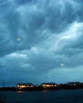
Tropical Storm Bret at 8pm
000
WTNT32 KNHC 172352
TCPAT2
BULLETIN
TROPICAL STORM BRET INTERMEDIATE ADVISORY NUMBER 1A
NWS NATIONAL HURRICANE CENTER MIAMI FL AL022011
800 PM EDT SUN JUL 17 2011
...TROPICAL DEPRESSION STRENGTHENS...BECOMES THE SECOND TROPICAL
STORM OF THE 2011 ATLANTIC HURRICANE SEASON...
000
WTNT32 KNHC 172352
TCPAT2
BULLETIN
TROPICAL STORM BRET INTERMEDIATE ADVISORY NUMBER 1A
NWS NATIONAL HURRICANE CENTER MIAMI FL AL022011
800 PM EDT SUN JUL 17 2011
...TROPICAL DEPRESSION STRENGTHENS...BECOMES THE SECOND TROPICAL
STORM OF THE 2011 ATLANTIC HURRICANE SEASON...
Last edited by Bocadude85 on Sun Jul 17, 2011 6:54 pm, edited 1 time in total.
0 likes
Who is online
Users browsing this forum: Google Adsense [Bot] and 7 guests