ATL: BRET - Remnants - Discussion
Moderator: S2k Moderators
-
Aric Dunn
- Category 5

- Posts: 21238
- Age: 43
- Joined: Sun Sep 19, 2004 9:58 pm
- Location: Ready for the Chase.
- Contact:
Im about to get the first mini squall from TD2/Bret 
0 likes
Note: If I make a post that is brief. Please refer back to previous posts for the analysis or reasoning. I do not re-write/qoute what my initial post said each time.
If there is nothing before... then just ask
Space & Atmospheric Physicist, Embry-Riddle Aeronautical University,
I believe the sky is falling...
If there is nothing before... then just ask
Space & Atmospheric Physicist, Embry-Riddle Aeronautical University,
I believe the sky is falling...
-
johngaltfla

- Category 5
- Posts: 2073
- Joined: Sun Jul 10, 2005 9:17 pm
- Location: Sarasota County, FL
- Contact:
Re:
artist wrote:http://www.nrlmry.navy.mil/tc-bin/tc_home2.cgi?YEAR=2011&MO=07&BASIN=ATL&STORM_NAME=02L.TWO&PROD=track_vis&PHOT=yes&ARCHIVE=active&NAV=tc&AGE=Latest&SIZE=Thumb&STYLE=tables&AID_DIR=/SATPRODUCTS/TC/tc11/ATL/02L.TWO/tpw/microvap&TYPE=ssmi
TD2
No we are getting into the "interesting" part of the season. With the weak steering currents, I wouldn't even venture a guess yet as to where it could be heading.
0 likes

Re: ATL: INVEST 98L - Recon
Latest
000
URNT15 KNHC 172022
AF304 01BBA INVEST HDOB 28 20110717
201230 2742N 07822W 9905 00202 0136 +221 +213 024022 023 019 000 00
201300 2741N 07821W 9904 00198 0133 +226 +213 024020 020 021 000 00
201330 2740N 07819W 9907 00194 0130 +231 +213 020019 020 019 001 03
201400 2739N 07818W 9909 00190 0128 +223 +213 022022 023 024 001 00
201430 2738N 07817W 9908 00189 0125 +222 +213 031020 021 024 001 00
201500 2737N 07815W 9906 00185 0119 +226 +213 042018 019 024 002 00
201530 2736N 07814W 9908 00178 0113 +230 +212 061020 021 025 002 00
201600 2735N 07813W 9911 00171 0106 +225 +212 058019 025 030 004 03
201630 2734N 07812W 9903 00173 0101 +235 +211 004006 009 012 000 00
201700 2733N 07810W 9903 00172 0100 +235 +209 290005 005 014 001 00
201730 2731N 07809W 9908 00168 0100 +236 +209 240011 017 022 003 00
201800 2730N 07808W 9910 00171 0105 +230 +211 207027 029 030 005 00
201830 2729N 07807W 9904 00179 0110 +229 +211 204029 031 031 003 00
201900 2729N 07806W 9767 00306 0116 +220 +211 206030 031 030 004 03
201930 2728N 07804W 9677 00395 0123 +224 +210 206030 031 023 005 03
202000 2728N 07802W 9673 00402 0129 +216 +210 209028 029 026 001 00
202030 2729N 07800W 9672 00405 0131 +219 +209 202027 028 022 002 00
202100 2729N 07759W 9669 00409 0132 +220 +208 201025 026 023 001 00
202130 2730N 07757W 9672 00407 0133 +223 +208 203025 027 022 001 00
202200 2731N 07755W 9675 00406 0135 +222 +208 208024 025 022 002 00
$$
;
0 likes
- Disclaimer: Posts herein are my amateur opinion only and should not be used for making important decisions. Defer to the NHC, NWS, and local authorities for official guidance.

When you think about it this system has sort of come out of no where, none of the models were ever that keen and even the NHC were caught out by this system's development.
0 likes
Personal Forecast Disclaimer:
The posts in this forum are NOT official forecast and should not be used as such. They are just the opinion of the poster and may or may not be backed by sound meteorological data. They are NOT endorsed by any professional institution or storm2k.org. For official information, please refer to the NHC and NWS products
The posts in this forum are NOT official forecast and should not be used as such. They are just the opinion of the poster and may or may not be backed by sound meteorological data. They are NOT endorsed by any professional institution or storm2k.org. For official information, please refer to the NHC and NWS products
-
Rgv20

- S2K Supporter

- Posts: 2466
- Age: 39
- Joined: Wed Jan 05, 2011 5:42 pm
- Location: Edinburg/McAllen Tx
Re: ATL: INVEST 98L - Discussion
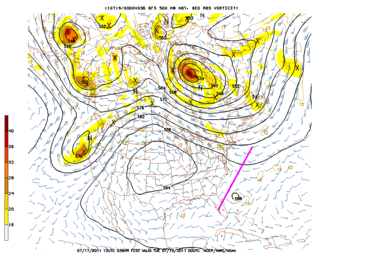
CronkPSU wrote:What will force it to move NE? I haven't heard of any fronts moving through my neck of the state
My best guess is that its going to feel the weakness in about 30 to 36 hrs represented by the pink line.
0 likes
The following post is NOT an official forecast and should not be used as such. It is just the opinion of the poster and may or may not be backed by sound meteorological data. It is NOT endorsed by any professional institution including storm2k.org For Official Information please refer to the NHC and NWS products.
-
johngaltfla
- Category 5
- Posts: 2073
- Joined: Sun Jul 10, 2005 9:17 pm
- Location: Sarasota County, FL
- Contact:
Re:
KWT wrote:When you think about it this system has sort of come out of no where, none of the models were ever that keen and even the NHC were caught out by this ssytems development.
That is exactly what grabbed my attention also. Haven't seen a storm like that develop so quickly in some time. The overnight period should be interesting.
0 likes
Re: ATL: INVEST 98L - Discussion
I think we would have a second system to deal with if that Alabama/Mississippi Low could get over water.
0 likes
-
Chris_in_Tampa
- Category 5
- Posts: 5101
- Age: 42
- Joined: Thu Jun 21, 2007 11:06 pm
- Location: Tampa, Florida, USA
- Contact:
Re: ATL: INVEST 98L - Recon
URNT12 KNHC 172028
VORTEX DATA MESSAGE AL982011
A. 17/20:16:40Z
B. 27 deg 34 min N
078 deg 11 min W
C. NA
D. 24 kt
E. 310 deg 5 nm
F. 060 deg 25 kt
G. 320 deg 2 nm
H. EXTRAP 1010 mb
I. 23 C / 189 m
J. 24 C / 188 m
K. 21 C / NA
L. NA
M. NA
N. 1234 / 01
O. 0.02 / 1 nm
P. AF304 01BBA INVEST OB 14
MAX FL WIND 25 KT NW QUAD 20:16:00Z
SLP EXTRAP FROM BELOW 1500 FT
;
Decoded:
Product: Air Force Vortex Message (URNT12 KNHC)
Transmitted: 17th day of the month at 20:28Z
Aircraft: Air Force Aircraft (Last 3 digits of the tail number are 304)
Mission Purpose: Investigate second suspect area (flight in the North Atlantic basin)
Mission Number: 1
Observation Number: 14
A. Time of Center Fix: 17th day of the month at 20:16:40Z
B. Center Fix Coordinates: 27°34'N 78°11'W (27.5667N 78.1833W)
B. Center Fix Location: 130 miles (209 km) to the ENE (63°) from West Palm Beach, FL, USA.
C. Minimum Height at Standard Level: Not Available
D. Estimated (by SFMR or visually) Maximum Surface Wind: 24kts (~ 27.6mph)
E. Location of the Estimated Maximum Surface Wind: 5 nautical miles (6 statute miles) to the NW (310°) of center fix
F. Maximum Flight Level Wind Inbound: From 60° at 25kts (From the ENE at ~ 28.8mph)
G. Location of Maximum Flight Level Wind Inbound: 2 nautical miles (2 statute miles) to the NW (320°) of center fix
H. Minimum Sea Level Pressure: 1010mb (29.83 inHg) - Extrapolated
I. Maximum Flight Level Temp & Pressure Altitude Outside Eye: 23°C (73°F) at a pressure alt. of 189m (620ft)
J. Maximum Flight Level Temp & Pressure Altitude Inside Eye: 24°C (75°F) at a pressure alt. of 188m (617ft)
K. Dewpoint Temp (collected at same location as temp inside eye): 21°C (70°F)
K. Sea Surface Temp (collected at same location as temp inside eye): Not Available
L. Eye Character: Not Available
M. Eye Shape: Not Available
N. Fix Determined By: Penetration, Radar, Wind and Pressure
N. Fix Levels (sfc and flt lvl centers are within 5nm of each other): Surface and 1,500 feet
O. Navigation Fix Accuracy: 0.02 nautical miles
O. Meteorological Accuracy: 1 nautical mile
Remarks Section:
Maximum Flight Level Wind: 25kts (~ 28.8mph) in the northwest quadrant at 20:16:00Z
Sea Level Pressure Extrapolation From: Below 1,500 feet
0 likes
-
cycloneye

- Admin

- Posts: 149429
- Age: 69
- Joined: Thu Oct 10, 2002 10:54 am
- Location: San Juan, Puerto Rico
ATL: BRET - Advisories
525
WTNT22 KNHC 172032
TCMAT2
TROPICAL DEPRESSION TWO FORECAST/ADVISORY NUMBER 1
NWS NATIONAL HURRICANE CENTER MIAMI FL AL022011
2100 UTC SUN JUL 17 2011
CHANGES IN WATCHES AND WARNINGS WITH THIS ADVISORY...
THE GOVERNMENT OF THE BAHAMAS HAS ISSUED A TROPICAL STORM WATCH FOR
GRAND BAHAMA ISLAND AND THE ABACO ISLANDS IN THE NORTHWEST BAHAMAS.
SUMMARY OF WATCHES AND WARNINGS IN EFFECT...
A TROPICAL STORM WATCH IS IN EFFECT FOR...
* GRAND BAHAMA ISLAND AND THE ABACO ISLANDS IN THE NORTHWEST BAHAMAS
TROPICAL DEPRESSION CENTER LOCATED NEAR 27.5N 78.2W AT 17/2100Z
POSITION ACCURATE WITHIN 30 NM
PRESENT MOVEMENT TOWARD THE SOUTH OR 180 DEGREES AT 2 KT
ESTIMATED MINIMUM CENTRAL PRESSURE 1010 MB
MAX SUSTAINED WINDS 30 KT WITH GUSTS TO 40 KT.
WINDS AND SEAS VARY GREATLY IN EACH QUADRANT. RADII IN NAUTICAL
MILES ARE THE LARGEST RADII EXPECTED ANYWHERE IN THAT QUADRANT.
REPEAT...CENTER LOCATED NEAR 27.5N 78.2W AT 17/2100Z
AT 17/1800Z CENTER WAS LOCATED NEAR 27.7N 78.2W
FORECAST VALID 18/0600Z 27.4N 78.2W
MAX WIND 40 KT...GUSTS 50 KT.
34 KT... 50NE 50SE 50SW 50NW.
FORECAST VALID 18/1800Z 28.2N 77.8W
MAX WIND 45 KT...GUSTS 55 KT.
34 KT... 60NE 60SE 60SW 60NW.
FORECAST VALID 19/0600Z 29.0N 77.3W
MAX WIND 50 KT...GUSTS 60 KT.
50 KT... 30NE 30SE 20SW 20NW.
34 KT... 75NE 75SE 75SW 75NW.
FORECAST VALID 19/1800Z 30.4N 76.5W
MAX WIND 50 KT...GUSTS 60 KT.
50 KT... 40NE 40SE 30SW 30NW.
34 KT... 90NE 90SE 90SW 90NW.
FORECAST VALID 20/1800Z 32.0N 73.5W
MAX WIND 50 KT...GUSTS 60 KT.
50 KT... 40NE 40SE 30SW 30NW.
34 KT... 90NE 90SE 90SW 90NW.
EXTENDED OUTLOOK. NOTE...ERRORS FOR TRACK HAVE AVERAGED NEAR 175 NM
ON DAY 4 AND 225 NM ON DAY 5...AND FOR INTENSITY NEAR 20 KT EACH DAY
OUTLOOK VALID 21/1800Z 34.0N 67.0W
MAX WIND 45 KT...GUSTS 55 KT.
OUTLOOK VALID 22/1800Z 36.0N 60.0W
MAX WIND 40 KT...GUSTS 50 KT.
REQUEST FOR 3 HOURLY SHIP REPORTS WITHIN 300 MILES OF 27.5N 78.2W
NEXT ADVISORY AT 18/0300Z
$$
FORECASTER PASCH/STEWART
WTNT32 KNHC 172034
TCPAT2
BULLETIN
TROPICAL DEPRESSION TWO ADVISORY NUMBER 1
NWS NATIONAL HURRICANE CENTER MIAMI FL AL022011
500 PM EDT SUN JUL 17 2011
...TROPICAL DEPRESSION FORMS JUST NORTH OF THE NORTHWEST BAHAMAS...
SUMMARY OF 500 PM EDT...2100 UTC...INFORMATION
----------------------------------------------
LOCATION...27.5N 78.2W
ABOUT 100 MI...165 KM NW OF GREAT ABACO ISLAND
MAXIMUM SUSTAINED WINDS...35 MPH...55 KM/H
PRESENT MOVEMENT...S OR 180 DEGREES AT 2 MPH...4 KM/H
MINIMUM CENTRAL PRESSURE...1010 MB...29.83 INCHES
WATCHES AND WARNINGS
--------------------
CHANGES WITH THIS ADVISORY...
THE GOVERNMENT OF THE BAHAMAS HAS ISSUED A TROPICAL STORM WATCH FOR
GRAND BAHAMA ISLAND AND THE ABACO ISLANDS IN THE NORTHWEST BAHAMAS.
SUMMARY OF WATCHES AND WARNINGS IN EFFECT...
A TROPICAL STORM WATCH IS IN EFFECT FOR...
* GRAND BAHAMA ISLAND AND THE ABACO ISLANDS IN THE NORTHWEST BAHAMAS
FOR STORM INFORMATION SPECIFIC TO YOUR AREA...PLEASE MONITOR
PRODUCTS ISSUED BY YOUR NATIONAL METEOROLOGICAL SERVICE.
DISCUSSION AND 48-HOUR OUTLOOK
------------------------------
AT 500 PM EDT...2100 UTC...THE CENTER OF TROPICAL DEPRESSION TWO WAS
LOCATED NEAR LATITUDE 27.5 NORTH...LONGITUDE 78.2 WEST. THE
DEPRESSION IS DRIFTING TOWARD THE SOUTH NEAR 2 MPH...4 KM/H...AND
LITTLE MOVEMENT IS EXPECTED OVERNIGHT...FOLLOWED BY A SLOW
NORTH-NORTHEASTWARD MOTION ON MONDAY.
MAXIMUM SUSTAINED WINDS ARE NEAR 35 MPH...55 KM/H...WITH HIGHER
GUSTS. SOME STRENGTHENING IS FORECAST DURING THE NEXT 48
HOURS...AND THE DEPRESSION COULD BECOME A TROPICAL STORM TONIGHT.
THE MINIMUM CENTRAL PRESSURE REPORTED BY AN AIR FORCE RESERVE UNIT
HURRICANE HUNTER AIRCRAFT WAS 1010 MB...29.83 INCHES.
HAZARDS AFFECTING LAND
----------------------
RAINFALL...THE DEPRESSION COULD PRODUCE TOTAL RAINFALL AMOUNTS OF 2
TO 3 INCHES OVER THE NORTHWEST BAHAMAS.
SURF...LOCALLY HIGH SURF CONDITIONS CAN BE EXPECTED ALONG NORTH AND
WESTERN FACING BEACHES IN THE NORTHWEST BAHAMAS THROUGH TONIGHT.
NEXT ADVISORY
-------------
NEXT INTERMEDIATE ADVISORY...800 PM EDT.
NEXT COMPLETE ADVISORY...1100 PM EDT.
$$
FORECASTER PASCH/STEWART
0 likes
Visit the Caribbean-Central America Weather Thread where you can find at first post web cams,radars
and observations from Caribbean basin members Click Here
and observations from Caribbean basin members Click Here
-
northjaxpro

- S2K Supporter
- Posts: 8900
- Joined: Mon Sep 27, 2010 11:21 am
- Location: Jacksonville, FL
KWT, some of the models all during last week were hinting at surface low development on the tail end of the frontal boundary off the SE US coast.
They were not bullish on development, but had a weak Low/inverted trough developing off the SC coast initailly. However 98L has it turned out developed much farther to the south.
They were not bullish on development, but had a weak Low/inverted trough developing off the SC coast initailly. However 98L has it turned out developed much farther to the south.
0 likes
NEVER, EVER SAY NEVER in the tropics and weather in general, and most importantly, with life itself!!
________________________________________________________________________________________
Fay 2008 Beryl 2012 Debby 2012 Colin 2016 Hermine 2016 Julia 2016 Matthew 2016 Irma 2017 Dorian 2019
________________________________________________________________________________________
Fay 2008 Beryl 2012 Debby 2012 Colin 2016 Hermine 2016 Julia 2016 Matthew 2016 Irma 2017 Dorian 2019
Re: ATL: INVEST 98L - Discussion
TROPICAL DEPRESSION TWO FORECAST/ADVISORY NUMBER 1
NWS NATIONAL HURRICANE CENTER MIAMI FL AL022011
2100 UTC SUN JUL 17 2011
CHANGES IN WATCHES AND WARNINGS WITH THIS ADVISORY...
THE GOVERNMENT OF THE BAHAMAS HAS ISSUED A TROPICAL STORM WATCH FOR
GRAND BAHAMA ISLAND AND THE ABACO ISLANDS IN THE NORTHWEST BAHAMAS.
SUMMARY OF WATCHES AND WARNINGS IN EFFECT...
A TROPICAL STORM WATCH IS IN EFFECT FOR...
* GRAND BAHAMA ISLAND AND THE ABACO ISLANDS IN THE NORTHWEST BAHAMAS
TROPICAL DEPRESSION CENTER LOCATED NEAR 27.5N 78.2W AT 17/2100Z
POSITION ACCURATE WITHIN 30 NM
PRESENT MOVEMENT TOWARD THE SOUTH OR 180 DEGREES AT 2 KT
ESTIMATED MINIMUM CENTRAL PRESSURE 1010 MB
MAX SUSTAINED WINDS 30 KT WITH GUSTS TO 40 KT.
WINDS AND SEAS VARY GREATLY IN EACH QUADRANT. RADII IN NAUTICAL
MILES ARE THE LARGEST RADII EXPECTED ANYWHERE IN THAT QUADRANT.
REPEAT...CENTER LOCATED NEAR 27.5N 78.2W AT 17/2100Z
AT 17/1800Z CENTER WAS LOCATED NEAR 27.7N 78.2W
FORECAST VALID 18/0600Z 27.4N 78.2W
MAX WIND 40 KT...GUSTS 50 KT.
34 KT... 50NE 50SE 50SW 50NW.
FORECAST VALID 18/1800Z 28.2N 77.8W
MAX WIND 45 KT...GUSTS 55 KT.
34 KT... 60NE 60SE 60SW 60NW.
FORECAST VALID 19/0600Z 29.0N 77.3W
MAX WIND 50 KT...GUSTS 60 KT.
50 KT... 30NE 30SE 20SW 20NW.
34 KT... 75NE 75SE 75SW 75NW.
FORECAST VALID 19/1800Z 30.4N 76.5W
MAX WIND 50 KT...GUSTS 60 KT.
50 KT... 40NE 40SE 30SW 30NW.
34 KT... 90NE 90SE 90SW 90NW.
FORECAST VALID 20/1800Z 32.0N 73.5W
MAX WIND 50 KT...GUSTS 60 KT.
50 KT... 40NE 40SE 30SW 30NW.
34 KT... 90NE 90SE 90SW 90NW.
EXTENDED OUTLOOK. NOTE...ERRORS FOR TRACK HAVE AVERAGED NEAR 175 NM
ON DAY 4 AND 225 NM ON DAY 5...AND FOR INTENSITY NEAR 20 KT EACH DAY
OUTLOOK VALID 21/1800Z 34.0N 67.0W
MAX WIND 45 KT...GUSTS 55 KT.
OUTLOOK VALID 22/1800Z 36.0N 60.0W
MAX WIND 40 KT...GUSTS 50 KT.
REQUEST FOR 3 HOURLY SHIP REPORTS WITHIN 300 MILES OF 27.5N 78.2W
NEXT ADVISORY AT 18/0300Z
$$
FORECASTER PASCH/STEWART
0 likes
Re: ATL: INVEST 98L - Recon
Extrapolated pressure at 1010mb.

Last edited by WxEnthus on Sun Jul 17, 2011 3:38 pm, edited 1 time in total.
0 likes
- Disclaimer: Posts herein are my amateur opinion only and should not be used for making important decisions. Defer to the NHC, NWS, and local authorities for official guidance.
-
SFLcane

- S2K Supporter
- Posts: 10281
- Age: 48
- Joined: Sat Jun 05, 2010 1:44 pm
- Location: Lake Worth Florida
Re: ATL: Tropical Depression Two - Discussion
Seems like it wont bother anyone but the dolphins...

0 likes
Re: ATL: Tropical Depression Two - Recon
Atlantic USAF High-Density Observations
000
URNT15 KNHC 172032
AF304 01BBA INVEST HDOB 29 20110717
202230 2732N 07753W 9670 00412 0137 +221 +208 204023 024 022 001 00
202300 2733N 07752W 9671 00412 0137 +224 +208 200024 025 025 000 00
202330 2733N 07750W 9675 00409 0139 +219 +208 198025 028 026 003 03
202400 2734N 07748W 9673 00409 0138 +218 +209 194027 030 022 004 03
202430 2734N 07746W 9645 00436 0140 +213 +208 160031 036 034 006 03
202500 2734N 07745W 9679 00403 0138 +208 +207 152038 040 034 005 00
202530 2735N 07743W 9671 00412 0138 +218 +205 162038 042 036 003 00
202600 2735N 07742W 9687 00400 0142 +216 +204 155032 034 033 004 00
202630 2735N 07740W 9661 00425 0146 +191 //// 149031 033 042 008 01
202700 2735N 07738W 9669 00420 0150 +195 //// 148027 027 037 010 01
202730 2735N 07737W 9671 00420 0154 +188 //// 143028 030 036 012 05
202800 2736N 07735W 9671 00421 0153 +190 +185 142031 032 036 013 00
202830 2737N 07734W 9672 00419 0150 +203 +180 136032 033 033 009 00
202900 2737N 07733W 9676 00418 0152 +205 +177 130031 032 032 006 03
202930 2739N 07732W 9670 00423 0152 +205 +176 124031 032 032 006 03
203000 2741N 07732W 9673 00419 0152 +198 +175 119034 035 032 008 00
203030 2742N 07732W 9674 00418 0152 +197 +175 111034 035 034 009 00
203100 2744N 07732W 9671 00422 0153 +200 +174 110035 035 033 009 00
203130 2745N 07732W 9664 00428 0156 +191 +172 107034 035 041 014 00
203200 2747N 07732W 9665 00430 0158 +179 +170 106033 035 044 013 00
$$
;
0 likes
- Disclaimer: Posts herein are my amateur opinion only and should not be used for making important decisions. Defer to the NHC, NWS, and local authorities for official guidance.
-
CrazyC83
- Professional-Met

- Posts: 34315
- Joined: Tue Mar 07, 2006 11:57 pm
- Location: Deep South, for the first time!
Re: ATL: Tropical Depression Two - Discussion
SFLcane wrote:Seems like it wont bother anyone but the dolphins...
It's sitting over islands now, and Bermuda is in the picture too.
0 likes
Very poor call again from the NHC given plenty of evidence of 35kts...ah well they've been behind the curve eright from the get-go!
I can only guess they think its weakened a touch over the last hour or two and hence goingwith a much more conservative figure.
Ps, estimate of 35kts again at the surface, 38kts this time round.
I can only guess they think its weakened a touch over the last hour or two and hence goingwith a much more conservative figure.
Ps, estimate of 35kts again at the surface, 38kts this time round.
0 likes
Personal Forecast Disclaimer:
The posts in this forum are NOT official forecast and should not be used as such. They are just the opinion of the poster and may or may not be backed by sound meteorological data. They are NOT endorsed by any professional institution or storm2k.org. For official information, please refer to the NHC and NWS products
The posts in this forum are NOT official forecast and should not be used as such. They are just the opinion of the poster and may or may not be backed by sound meteorological data. They are NOT endorsed by any professional institution or storm2k.org. For official information, please refer to the NHC and NWS products
-
SFLcane
- S2K Supporter
- Posts: 10281
- Age: 48
- Joined: Sat Jun 05, 2010 1:44 pm
- Location: Lake Worth Florida
Re: ATL: Tropical Depression Two - Discussion
CrazyC83 wrote:SFLcane wrote:Seems like it wont bother anyone but the dolphins...
It's sitting over islands now, and Bermuda is in the picture too.
Some squally weather for the bahamas...Once it passes close to bermuda it will likely be a sheared mess.
0 likes
I don't think we are going to get much strengthening out of this system, conditions look only marginal for strengthening IMO. i personally think the NHC's call of 50kts maybe a touch high, but then again doesn't take that much to get to that strength, i've seen real messes get to that before.
Should be Bret right now though...and post season WILL upgrade and need to backtrack if it does offically become Bret, I'm pretty sure of it.
Should be Bret right now though...and post season WILL upgrade and need to backtrack if it does offically become Bret, I'm pretty sure of it.
0 likes
Personal Forecast Disclaimer:
The posts in this forum are NOT official forecast and should not be used as such. They are just the opinion of the poster and may or may not be backed by sound meteorological data. They are NOT endorsed by any professional institution or storm2k.org. For official information, please refer to the NHC and NWS products
The posts in this forum are NOT official forecast and should not be used as such. They are just the opinion of the poster and may or may not be backed by sound meteorological data. They are NOT endorsed by any professional institution or storm2k.org. For official information, please refer to the NHC and NWS products
-
Aric Dunn
- Category 5
- Posts: 21238
- Age: 43
- Joined: Sun Sep 19, 2004 9:58 pm
- Location: Ready for the Chase.
- Contact:
The NHC is a little fast... I beleive they are just going off the models at the moment... problem is the models have not even initialized a low yet.. let a alone one 5 mb lower than the background pressure. the models should change at 00z... only thing that may throw a wrench in it is the low to the east of the of TD 2 that it may start to interact with shortly and cause some erratic motions.. probably to the SSE... only time will tell..
0 likes
Note: If I make a post that is brief. Please refer back to previous posts for the analysis or reasoning. I do not re-write/qoute what my initial post said each time.
If there is nothing before... then just ask
Space & Atmospheric Physicist, Embry-Riddle Aeronautical University,
I believe the sky is falling...
If there is nothing before... then just ask
Space & Atmospheric Physicist, Embry-Riddle Aeronautical University,
I believe the sky is falling...
Who is online
Users browsing this forum: No registered users and 15 guests