Post away about this system.
BEGIN
NHC_ATCF
invest_al952011.invest
FSTDA
R
U
040
010
0000
201106271901
NONE
NOTIFY=ATRP
END
INVEST, AL, L, , , , , 95, 2011, DB, O, 2011062718, 9999999999, , , , , , METWATCH, , AL952011
AL, 95, 2011062618, , BEST, 0, 197N, 900W, 20, 1009, DB, 0, , 0, 0, 0, 0,
AL, 95, 2011062700, , BEST, 0, 198N, 903W, 20, 1009, DB, 0, , 0, 0, 0, 0,
AL, 95, 2011062706, , BEST, 0, 199N, 905W, 20, 1009, DB, 0, , 0, 0, 0, 0,
AL, 95, 2011062712, , BEST, 0, 199N, 907W, 20, 1009, DB, 0, , 0, 0, 0, 0,
AL, 95, 2011062718, , BEST, 0, 200N, 910W, 20, 1008, DB, 34, NEQ
ftp://ftp.tpc.ncep.noaa.gov/atcf/tcweb/ ... 011.invest
ATL: ARLENE - Remnants
Moderator: S2k Moderators
-
cycloneye

- Admin

- Posts: 149425
- Age: 69
- Joined: Thu Oct 10, 2002 10:54 am
- Location: San Juan, Puerto Rico
ATL: ARLENE - Remnants
0 likes
Visit the Caribbean-Central America Weather Thread where you can find at first post web cams,radars
and observations from Caribbean basin members Click Here
and observations from Caribbean basin members Click Here
-
SouthDadeFish

- Professional-Met

- Posts: 2835
- Joined: Thu Sep 23, 2010 2:54 pm
- Location: Miami, FL
- Contact:
-
wxman57

- Moderator-Pro Met

- Posts: 23174
- Age: 68
- Joined: Sat Jun 21, 2003 8:06 pm
- Location: Houston, TX (southwest)
Re: ATL: INVEST 95L - Discussion
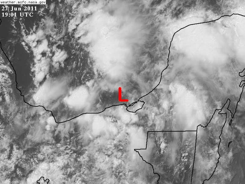
Still not much there. I can identify a broad weak area of low pressure in the southern BoC, but nothing at the surface near 20N/91W. Any development would be slow to occur and not likely happen until 12-24 hours before it moves ashore into Mexico. That would be tomorrow afternoon.

0 likes
-
SouthDadeFish
- Professional-Met
- Posts: 2835
- Joined: Thu Sep 23, 2010 2:54 pm
- Location: Miami, FL
- Contact:
Looking at high-res visible loops I've spotted a couple of eddies swirling around the broad area of low pressure. Well, they have been somewhat stationary. One is located near 18N, 91W, and the other near 20N, 92.5W. All I take from that is vorticity is increasing in the region and once shear relaxes, we could start to see some organization starting tomorrow afternoon.
0 likes
-
cycloneye
- Admin
- Posts: 149425
- Age: 69
- Joined: Thu Oct 10, 2002 10:54 am
- Location: San Juan, Puerto Rico
Re: ATL: INVEST 95L - Discussion

0 likes
Visit the Caribbean-Central America Weather Thread where you can find at first post web cams,radars
and observations from Caribbean basin members Click Here
and observations from Caribbean basin members Click Here
-
SouthDadeFish
- Professional-Met
- Posts: 2835
- Joined: Thu Sep 23, 2010 2:54 pm
- Location: Miami, FL
- Contact:
Check out the RGB loop and you can see that the NW low level clouds have begun to rotate more strongly around the broad low as the day has progressed.
http://www.ssd.noaa.gov/goes/east/gmex/flash-rgb.html
http://www.ssd.noaa.gov/goes/east/gmex/flash-rgb.html
0 likes

Re: ATL: INVEST 95L - Discussion
wxman57 wrote:Still not much there. I can identify a broad weak area of low pressure in the southern BoC, but nothing at the surface near 20N/91W. Any development would be slow to occur and not likely happen until 12-24 hours before it moves ashore into Mexico. That would be tomorrow afternoon.
http://myweb.cableone.net/nolasue/95La.gif
I still think your "L" is too far north, Ciudad del Carmen is still reporting the lowest surface pressures with calm winds, areas to the W of that city are reporting northerly winds.
0 likes
-
wxman57
- Moderator-Pro Met
- Posts: 23174
- Age: 68
- Joined: Sat Jun 21, 2003 8:06 pm
- Location: Houston, TX (southwest)
Re: ATL: INVEST 95L - Discussion
NDG wrote:wxman57 wrote:Still not much there. I can identify a broad weak area of low pressure in the southern BoC, but nothing at the surface near 20N/91W. Any development would be slow to occur and not likely happen until 12-24 hours before it moves ashore into Mexico. That would be tomorrow afternoon.
http://myweb.cableone.net/nolasue/95La.gif
I still think your "L" is too far north, Ciudad del Carmen is still reporting the lowest surface pressures with calm winds, areas to the W of that city are reporting northerly winds.
I agree, that's the NHC's "L" as per their invest location of 20N/91W. I don't see anything at the surface there.
0 likes

Re: ATL: INVEST 95L - Discussion
The outflow has been fairly well-defined since yesterday, but as you said not much expected as it moves towards Mexico...
Another fairly active wave north-south across Puerto Rico at this time with most of the convection south of Puerto Rico...
Frank
Another fairly active wave north-south across Puerto Rico at this time with most of the convection south of Puerto Rico...
Frank
Last edited by Frank2 on Mon Jun 27, 2011 2:55 pm, edited 1 time in total.
0 likes
-
cycloneye
- Admin
- Posts: 149425
- Age: 69
- Joined: Thu Oct 10, 2002 10:54 am
- Location: San Juan, Puerto Rico
ATL: ARLENE - Recon
The first mission is slated for tuesday afternoon (If Needed) Here is the TCPOD for Tuesday and Wednesday.
Code: Select all
WEATHER RECONNAISSANCE FLIGHTS
CARCAH, NATIONAL HURRICANE CENTER, MIAMI, FL.
0130 PM EDT MON 27 JUNE 2011
SUBJECT: TROPICAL CYCLONE PLAN OF THE DAY (TCPOD)
         VALID 28/1100Z TO 29/1100Z JUNE 2011
         TCPOD NUMBER.....11-027

I.  ATLANTIC REQUIREMENTS
    1. FLIGHT ONE -- TEAL 70
       A. 28/1800Z
       B. AFXXX 01AAA INVEST
       C. 28/1515Z
       D. 21.0N 94.0W
       E. 28/1730Z TO 28/2200Z
       F. SFC TO 10,000 FT

       FLIGHT TWO -- TEAL 71
       A. 29/1200Z
       B. AFXXX 0201A CYCLONE
       C. 29/0930Z
       D. 22.0N 96.0W
       E. 29/1130Z TO 29/1600Z
       F. SFC TO 10,000 FT.

    2. OUTLOOK FOR SUCCEEDING DAY: CONTINUE 12-HRLY
       FIXES WHILE SYSTEM REMAINS A THREAT.
0 likes
Visit the Caribbean-Central America Weather Thread where you can find at first post web cams,radars
and observations from Caribbean basin members Click Here
and observations from Caribbean basin members Click Here

-
cycloneye
- Admin
- Posts: 149425
- Age: 69
- Joined: Thu Oct 10, 2002 10:54 am
- Location: San Juan, Puerto Rico
ATL: ARLENE - Models
Ship brings it up to 42 kts.

Code: Select all
WHXX01 KWBC 271903
CHGHUR
TROPICAL CYCLONE GUIDANCE MESSAGE
NWS NATIONAL HURRICANE CENTER MIAMI FL
1903 UTC MON JUN 27 2011

DISCLAIMER...NUMERICAL MODELS ARE SUBJECT TO LARGE ERRORS.
PLEASE REFER TO NHC OFFICIAL FORECASTS FOR TROPICAL CYCLONE
AND SUBTROPICAL CYCLONE INFORMATION.

ATLANTIC OBJECTIVE AIDS FOR

DISTURBANCE INVEST (AL952011) 20110627 1800 UTC

        ...00 HRS...   ...12 HRS...   ...24 HRS. ..   ...36 HRS...
        110627  1800   110628  0600   110628  1800   110629  0600

         LAT    LON     LAT    LON     LAT    LON     LAT    LON
BAMS    20.0N  91.0W   20.9N  93.2W   21.3N  95.2W   21.3N  96.9W
BAMD    20.0N  91.0W   20.8N  92.5W   21.3N  94.0W   21.7N  95.6W
BAMM    20.0N  91.0W   20.8N  92.8W   21.2N  94.7W   21.3N  96.4W
LBAR    20.0N  91.0W   20.8N  92.1W   21.6N  93.6W   22.6N  95.4W
SHIP        20KTS          26KTS          34KTS          42KTS
DSHP        20KTS          26KTS          34KTS          42KTS

        ...48 HRS...   ...72 HRS...   ...96 HRS. ..   ..120 HRS...
        110629  1800   110630  1800   110701  1800   110702  1800

         LAT    LON     LAT    LON     LAT    LON     LAT    LON
BAMS    21.1N  98.5W   20.9N 101.2W   20.9N 103.5W   21.3N 106.6W
BAMD    22.0N  97.3W   22.3N 101.0W   22.6N 104.6W   23.2N 108.2W
BAMM    21.3N  98.1W   21.2N 101.3W   21.0N 104.5W   21.2N 107.8W
LBAR    23.4N  97.4W   25.2N 101.7W   27.4N 105.6W   30.2N 109.1W
SHIP        49KTS          62KTS          70KTS          69KTS
DSHP        37KTS          28KTS          27KTS          28KTS

         ...INITIAL CONDITIONS...
LATCUR =  20.0N LONCUR =  91.0W DIRCUR = 285DEG SPDCUR =   3KT
LATM12 =  19.9N LONM12 =  90.5W DIRM12 = 285DEG SPDM12 =   2KT
LATM24 =  19.7N LONM24 =  90.0W
WNDCUR =   20KT RMAXWD =   60NM WNDM12 =   20KT
CENPRS = 1008MB OUTPRS = 1010MB OUTRAD =  150NM SDEPTH =   M
RD34NE =    0NM RD34SE =    0NM RD34SW =    0NM RD34NW =   0NM
0 likes
Visit the Caribbean-Central America Weather Thread where you can find at first post web cams,radars
and observations from Caribbean basin members Click Here
and observations from Caribbean basin members Click Here


-
cycloneye
- Admin
- Posts: 149425
- Age: 69
- Joined: Thu Oct 10, 2002 10:54 am
- Location: San Juan, Puerto Rico
Re: ATL: INVEST 95L - Discussion
lebron23 wrote:Model runs?
There is now the models thread.
0 likes
Visit the Caribbean-Central America Weather Thread where you can find at first post web cams,radars
and observations from Caribbean basin members Click Here
and observations from Caribbean basin members Click Here
Re: ATL: INVEST 95L - Discussion
wxman57 wrote:NDG wrote:wxman57 wrote:Still not much there. I can identify a broad weak area of low pressure in the southern BoC, but nothing at the surface near 20N/91W. Any development would be slow to occur and not likely happen until 12-24 hours before it moves ashore into Mexico. That would be tomorrow afternoon.
http://myweb.cableone.net/nolasue/95La.gif
I still think your "L" is too far north, Ciudad del Carmen is still reporting the lowest surface pressures with calm winds, areas to the W of that city are reporting northerly winds.
I agree, that's the NHC's "L" as per their invest location of 20N/91W. I don't see anything at the surface there.
OK, no problem, I had no idea that you were going by the NHC best of track.
BTW, this is where I think the broad low pressure center is approximately located, if not just inland from there.
0 likes

Re: ATL: INVEST 95L - Discussion
Just to the west of your L there is an eddy that can be seen easily on the VIS loop
0 likes
The following post is NOT an official forecast and should not be used as such. It is just the opinion of the poster and may or may not be backed by sound meteorological data. It is NOT endorsed by any professional institution including storm2k.org For Official Information please refer to the NHC and NWS products.
-
cycloneye
- Admin
- Posts: 149425
- Age: 69
- Joined: Thu Oct 10, 2002 10:54 am
- Location: San Juan, Puerto Rico
Re: ATL : INVEST 95L - Models
Imagine if the clipper model is right.  The drought buster all the way! But seriously,I dont know why that model has that track with the ridge parked over Texas/Louisiana.
0 likes
Visit the Caribbean-Central America Weather Thread where you can find at first post web cams,radars
and observations from Caribbean basin members Click Here
and observations from Caribbean basin members Click Here
-
Brent
- S2K Supporter

- Posts: 38745
- Age: 37
- Joined: Sun May 16, 2004 10:30 pm
- Location: Tulsa Oklahoma
- Contact:
Re: ATL : INVEST 95L - Models
cycloneye wrote:Imagine if the clipper model is right.
It's climo and doesn't use any current pattern...
0 likes
#neversummer
Re: ATL: INVEST 95L - Discussion
tailgater wrote::uarrow:
Just to the west of your L there is an eddy that can be seen easily on the VIS loop
Yeah, I noticed that but seems to be rotating soutward.
0 likes
Re: ATL: INVEST 95L - Discussion
NDG wrote:tailgater wrote::uarrow:
Just to the west of your L there is an eddy that can be seen easily on the VIS loop
Yeah, I noticed that but seems to be rotating soutward.
As you(I think it was you) said it's probably rotating around the wave axis. There is just not much to this invest yet.
0 likes
The following post is NOT an official forecast and should not be used as such. It is just the opinion of the poster and may or may not be backed by sound meteorological data. It is NOT endorsed by any professional institution including storm2k.org For Official Information please refer to the NHC and NWS products.
Who is online
Users browsing this forum: No registered users and 9 guests