WPAC: SONGDA - Tropical Depression (1102/04W)
Moderator: S2k Moderators
-
oaba09
- S2K Supporter

- Posts: 1496
- Age: 39
- Joined: Thu Oct 01, 2009 10:02 am
- Location: Valenzuela, Philippines
- Contact:
Still a STS per JMA

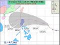
STS 1102 (Songda)
Issued at 21:40 UTC, 24 May 2011
<Analyses at 24/21 UTC>
Scale -
Intensity -
Center position N12°30'(12.5°)
E128°20'(128.3°)
Direction and speed of movement W 15km/h(7kt)
Central pressure 975hPa
Maximum wind speed near the center 30m/s(60kt)
Maximum wind gust speed 45m/s(85kt)
Area of 50kt winds or more Wide 90km(50NM)
Area of 30kt winds or more NE330km(180NM)
SW260km(140NM)
<Forecast for 25/21 UTC>
Intensity Strong
Center position of probability circle N14°05'(14.1°)
E126°20'(126.3°)
Direction and speed of movement NW 10km/h(6kt)
Central pressure 960hPa
Maximum wind speed near the center 40m/s(75kt)
Maximum wind gust speed 55m/s(105kt)
Radius of probability circle 130km(70NM)
Storm warning area Wide 260km(140NM)
<Forecast for 26/18 UTC>
Intensity Strong
Center position of probability circle N16°25'(16.4°)
E124°20'(124.3°)
Direction and speed of movement NW 15km/h(8kt)
Central pressure 945hPa
Maximum wind speed near the center 40m/s(80kt)
Maximum wind gust speed 60m/s(115kt)
Radius of probability circle 200km(110NM)
Storm warning area Wide 350km(190NM)
<Forecast for 27/18 UTC>
Intensity Strong
Center position of probability circle N19°55'(19.9°)
E122°35'(122.6°)
Direction and speed of movement NNW 20km/h(10kt)
Central pressure 945hPa
Maximum wind speed near the center 40m/s(80kt)
Maximum wind gust speed 60m/s(115kt)
Radius of probability circle 300km(160NM)
Storm warning area Wide 440km(240NM)
<Forecast for 28/18 UTC>
Center position of probability circle N22°35'(22.6°)
E122°55'(122.9°)
Direction and speed of movement N 15km/h(7kt)
Radius of probability circle 650km(350NM)
<Forecast for 29/18 UTC>
Center position of probability circle N26°00'(26.0°)
E125°55'(125.9°)
Direction and speed of movement NE 20km/h(11kt)
Radius of probability circle 950km(500NM)
0 likes
-
phwxenthusiast
- Category 2

- Posts: 637
- Joined: Wed Mar 24, 2010 3:10 am
- Location: Holbrook, NY (Long Island)
-
ManilaTC

- WesternPacificWeather.com

- Posts: 593
- Age: 47
- Joined: Mon Oct 26, 2009 5:13 am
- Location: Mandaluyong City, Philippines
- Contact:
Actually none of em are budging... reminds me of TY FENGSHEN/FRANK in 2008, wherein models remain for days giving a recurvature scenario... storm hit land then recurved in the middle of visayas into Luzon and Metro Manila.
0 likes
The above post is NOT official and should not be used as such. It is my opinion and may or may not be backed by sound meteorological data. It is not endorsed by any professional institution or storm2k.org. Please refer to your official national weather agency.
WEB http://goo.gl/JDiKXB | FB https://goo.gl/N5sIle | @ManilaTC
WEB http://goo.gl/JDiKXB | FB https://goo.gl/N5sIle | @ManilaTC
-
climateconcern23
- Tropical Low

- Posts: 35
- Age: 35
- Joined: Sat Mar 05, 2011 4:38 am
- Location: Philippines
- Contact:
Re: WPAC: SONGDA - Severe Tropical Storm (1102/04W)
If Songda continues its direction then BICOL is in grave of danger.
0 likes

-
ManilaTC
- WesternPacificWeather.com
- Posts: 593
- Age: 47
- Joined: Mon Oct 26, 2009 5:13 am
- Location: Mandaluyong City, Philippines
- Contact:
Re: WPAC: SONGDA - Severe Tropical Storm (1102/04W)
climateconcern23 wrote:If Songda continues its direction then BICOL is in grave of danger.
Where in the beautiful country of ours are you at, man?
0 likes
The above post is NOT official and should not be used as such. It is my opinion and may or may not be backed by sound meteorological data. It is not endorsed by any professional institution or storm2k.org. Please refer to your official national weather agency.
WEB http://goo.gl/JDiKXB | FB https://goo.gl/N5sIle | @ManilaTC
WEB http://goo.gl/JDiKXB | FB https://goo.gl/N5sIle | @ManilaTC
-
ManilaTC
- WesternPacificWeather.com
- Posts: 593
- Age: 47
- Joined: Mon Oct 26, 2009 5:13 am
- Location: Mandaluyong City, Philippines
- Contact:
If the storm does not go Northwest by sundown today, then we are in for something here. I have this gut feeling...
Typhoon sense is tingling...
Typhoon sense is tingling...
0 likes
The above post is NOT official and should not be used as such. It is my opinion and may or may not be backed by sound meteorological data. It is not endorsed by any professional institution or storm2k.org. Please refer to your official national weather agency.
WEB http://goo.gl/JDiKXB | FB https://goo.gl/N5sIle | @ManilaTC
WEB http://goo.gl/JDiKXB | FB https://goo.gl/N5sIle | @ManilaTC

-
rdhdstpchld
- Tropical Depression

- Posts: 79
- Joined: Mon May 09, 2011 3:47 am
Re: WPAC: SONGDA - Severe Tropical Storm (1102/04W)
Can anyone point to a sight where you can watch the sat loop from start to current position? I want to show my kids how it develops, moves, etc. Thanks!
0 likes
-
HURAKAN

- Professional-Met

- Posts: 46084
- Age: 39
- Joined: Thu May 20, 2004 4:34 pm
- Location: Key West, FL
- Contact:
Re: WPAC: SONGDA - Severe Tropical Storm (1102/04W)
rdhdstpchld wrote:Can anyone point to a sight where you can watch the sat loop from start to current position? I want to show my kids how it develops, moves, etc. Thanks!
Here you go!
http://rammb.cira.colostate.edu/product ... r=WP042011
0 likes
-
rdhdstpchld
- Tropical Depression
- Posts: 79
- Joined: Mon May 09, 2011 3:47 am
Re: WPAC: SONGDA - Severe Tropical Storm (1102/04W)
HURAKAN wrote:rdhdstpchld wrote:Can anyone point to a sight where you can watch the sat loop from start to current position? I want to show my kids how it develops, moves, etc. Thanks!
Here you go!
http://rammb.cira.colostate.edu/product ... r=WP042011
Thanks much, Hurakan!!
0 likes

-
cycloneye

- Admin

- Posts: 149429
- Age: 69
- Joined: Thu Oct 10, 2002 10:54 am
- Location: San Juan, Puerto Rico
Re: WPAC: SONGDA - Severe Tropical Storm (1102/04W)
JMA Upgrades to Typhoon
TY 1102 (Songda)
Issued at 00:40 UTC, 25 May 2011
<Analyses at 25/00 UTC>
Scale -
Intensity Strong
Center position N12°30'(12.5°)
E128°10'(128.2°)
Direction and speed of movement W Slowly
Central pressure 960hPa
Maximum wind speed near the center 40m/s(75kt)
Maximum wind gust speed 55m/s(105kt)
Area of 50kt winds or more Wide 130km(70NM)
Area of 30kt winds or more NE330km(180NM)
SW260km(140NM)
<Forecast for 26/00 UTC>
Intensity Strong
Center position of probability circle N14°10'(14.2°)
E126°10'(126.2°)
Direction and speed of movement NW 10km/h(6kt)
Central pressure 950hPa
Maximum wind speed near the center 40m/s(80kt)
Maximum wind gust speed 60m/s(115kt)
Radius of probability circle 130km(70NM)
Storm warning area Wide 280km(150NM)
<Forecast for 27/00 UTC>
Intensity Strong
Center position of probability circle N16°50'(16.8°)
E124°25'(124.4°)
Direction and speed of movement NNW 15km/h(8kt)
Central pressure 945hPa
Maximum wind speed near the center 40m/s(80kt)
Maximum wind gust speed 60m/s(115kt)
Radius of probability circle 200km(110NM)
Storm warning area Wide 350km(190NM)
<Forecast for 28/00 UTC>
Intensity Strong
Center position of probability circle N20°30'(20.5°)
E123°05'(123.1°)
Direction and speed of movement NNW 20km/h(10kt)
Central pressure 945hPa
Maximum wind speed near the center 40m/s(80kt)
Maximum wind gust speed 60m/s(115kt)
Radius of probability circle 300km(160NM)
Storm warning area Wide 440km(240NM)
0 likes
Visit the Caribbean-Central America Weather Thread where you can find at first post web cams,radars
and observations from Caribbean basin members Click Here
and observations from Caribbean basin members Click Here
-
oaba09
- S2K Supporter
- Posts: 1496
- Age: 39
- Joined: Thu Oct 01, 2009 10:02 am
- Location: Valenzuela, Philippines
- Contact:
Interesting article below...
"Chedeng moves eratically"
Source: http://www.voxbikol.com/article/chedeng ... rratically
"Chedeng moves eratically"
Source: http://www.voxbikol.com/article/chedeng ... rratically
0 likes
-
ManilaTC
- WesternPacificWeather.com
- Posts: 593
- Age: 47
- Joined: Mon Oct 26, 2009 5:13 am
- Location: Mandaluyong City, Philippines
- Contact:
Re: WPAC: SONGDA - Typhoon (1102/04W)
This seems to be a problem, probable reason why Chedeng/Songda is tracking West-WNW right now
0 likes
The above post is NOT official and should not be used as such. It is my opinion and may or may not be backed by sound meteorological data. It is not endorsed by any professional institution or storm2k.org. Please refer to your official national weather agency.
WEB http://goo.gl/JDiKXB | FB https://goo.gl/N5sIle | @ManilaTC
WEB http://goo.gl/JDiKXB | FB https://goo.gl/N5sIle | @ManilaTC
-
ManilaTC
- WesternPacificWeather.com
- Posts: 593
- Age: 47
- Joined: Mon Oct 26, 2009 5:13 am
- Location: Mandaluyong City, Philippines
- Contact:
Re: WPAC: SONGDA - Typhoon (1102/04W)
Also this one...
0 likes
The above post is NOT official and should not be used as such. It is my opinion and may or may not be backed by sound meteorological data. It is not endorsed by any professional institution or storm2k.org. Please refer to your official national weather agency.
WEB http://goo.gl/JDiKXB | FB https://goo.gl/N5sIle | @ManilaTC
WEB http://goo.gl/JDiKXB | FB https://goo.gl/N5sIle | @ManilaTC
-
HURAKAN
- Professional-Met
- Posts: 46084
- Age: 39
- Joined: Thu May 20, 2004 4:34 pm
- Location: Key West, FL
- Contact:
90 knots

WTPN31 PGTW 250300
MSGID/GENADMIN/NAVMARFCSTCEN PEARL HARBOR HI/JTWC//
SUBJ/TROPICAL CYCLONE WARNING//
RMKS/
1. TYPHOON 04W (SONGDA) WARNING NR 020
01 ACTIVE TROPICAL CYCLONE IN NORTHWESTPAC
MAX SUSTAINED WINDS BASED ON ONE-MINUTE AVERAGE
WIND RADII VALID OVER OPEN WATER ONLY
---
WARNING POSITION:
250000Z --- NEAR 12.4N 128.1E
MOVEMENT PAST SIX HOURS - 290 DEGREES AT 05 KTS
POSITION ACCURATE TO WITHIN 030 NM
POSITION BASED ON EYE FIXED BY SATELLITE
PRESENT WIND DISTRIBUTION:
MAX SUSTAINED WINDS - 090 KT, GUSTS 110 KT
WIND RADII VALID OVER OPEN WATER ONLY
RADIUS OF 064 KT WINDS - 035 NM NORTHEAST QUADRANT
030 NM SOUTHEAST QUADRANT
030 NM SOUTHWEST QUADRANT
035 NM NORTHWEST QUADRANT
RADIUS OF 050 KT WINDS - 055 NM NORTHEAST QUADRANT
050 NM SOUTHEAST QUADRANT
050 NM SOUTHWEST QUADRANT
055 NM NORTHWEST QUADRANT
RADIUS OF 034 KT WINDS - 115 NM NORTHEAST QUADRANT
105 NM SOUTHEAST QUADRANT
105 NM SOUTHWEST QUADRANT
115 NM NORTHWEST QUADRANT
REPEAT POSIT: 12.4N 128.1E
---
FORECASTS:
12 HRS, VALID AT:
251200Z --- 13.5N 126.8E
MAX SUSTAINED WINDS - 100 KT, GUSTS 125 KT
WIND RADII VALID OVER OPEN WATER ONLY
RADIUS OF 064 KT WINDS - 040 NM NORTHEAST QUADRANT
035 NM SOUTHEAST QUADRANT
035 NM SOUTHWEST QUADRANT
040 NM NORTHWEST QUADRANT
RADIUS OF 050 KT WINDS - 060 NM NORTHEAST QUADRANT
055 NM SOUTHEAST QUADRANT
055 NM SOUTHWEST QUADRANT
060 NM NORTHWEST QUADRANT
RADIUS OF 034 KT WINDS - 120 NM NORTHEAST QUADRANT
110 NM SOUTHEAST QUADRANT
110 NM SOUTHWEST QUADRANT
120 NM NORTHWEST QUADRANT
VECTOR TO 24 HR POSIT: 325 DEG/ 09 KTS
---
24 HRS, VALID AT:
260000Z --- 14.9N 125.7E
MAX SUSTAINED WINDS - 110 KT, GUSTS 135 KT
WIND RADII VALID OVER OPEN WATER ONLY
RADIUS OF 064 KT WINDS - 040 NM NORTHEAST QUADRANT
040 NM SOUTHEAST QUADRANT
040 NM SOUTHWEST QUADRANT
040 NM NORTHWEST QUADRANT
RADIUS OF 050 KT WINDS - 065 NM NORTHEAST QUADRANT
065 NM SOUTHEAST QUADRANT
060 NM SOUTHWEST QUADRANT
065 NM NORTHWEST QUADRANT
RADIUS OF 034 KT WINDS - 125 NM NORTHEAST QUADRANT
120 NM SOUTHEAST QUADRANT
115 NM SOUTHWEST QUADRANT
125 NM NORTHWEST QUADRANT
VECTOR TO 36 HR POSIT: 330 DEG/ 07 KTS
---
36 HRS, VALID AT:
261200Z --- 16.1N 125.0E
MAX SUSTAINED WINDS - 115 KT, GUSTS 140 KT
WIND RADII VALID OVER OPEN WATER ONLY
RADIUS OF 064 KT WINDS - 045 NM NORTHEAST QUADRANT
040 NM SOUTHEAST QUADRANT
040 NM SOUTHWEST QUADRANT
040 NM NORTHWEST QUADRANT
RADIUS OF 050 KT WINDS - 070 NM NORTHEAST QUADRANT
065 NM SOUTHEAST QUADRANT
065 NM SOUTHWEST QUADRANT
065 NM NORTHWEST QUADRANT
RADIUS OF 034 KT WINDS - 130 NM NORTHEAST QUADRANT
125 NM SOUTHEAST QUADRANT
120 NM SOUTHWEST QUADRANT
125 NM NORTHWEST QUADRANT
VECTOR TO 48 HR POSIT: 340 DEG/ 11 KTS
---
EXTENDED OUTLOOK:
48 HRS, VALID AT:
270000Z --- 18.1N 124.3E
MAX SUSTAINED WINDS - 110 KT, GUSTS 135 KT
WIND RADII VALID OVER OPEN WATER ONLY
RADIUS OF 064 KT WINDS - 040 NM NORTHEAST QUADRANT
040 NM SOUTHEAST QUADRANT
040 NM SOUTHWEST QUADRANT
040 NM NORTHWEST QUADRANT
RADIUS OF 050 KT WINDS - 070 NM NORTHEAST QUADRANT
065 NM SOUTHEAST QUADRANT
065 NM SOUTHWEST QUADRANT
065 NM NORTHWEST QUADRANT
RADIUS OF 034 KT WINDS - 130 NM NORTHEAST QUADRANT
130 NM SOUTHEAST QUADRANT
125 NM SOUTHWEST QUADRANT
125 NM NORTHWEST QUADRANT
VECTOR TO 72 HR POSIT: 005 DEG/ 11 KTS
---
72 HRS, VALID AT:
280000Z --- 22.6N 124.8E
MAX SUSTAINED WINDS - 105 KT, GUSTS 130 KT
WIND RADII VALID OVER OPEN WATER ONLY
RADIUS OF 064 KT WINDS - 040 NM NORTHEAST QUADRANT
040 NM SOUTHEAST QUADRANT
040 NM SOUTHWEST QUADRANT
040 NM NORTHWEST QUADRANT
RADIUS OF 050 KT WINDS - 070 NM NORTHEAST QUADRANT
070 NM SOUTHEAST QUADRANT
065 NM SOUTHWEST QUADRANT
065 NM NORTHWEST QUADRANT
RADIUS OF 034 KT WINDS - 140 NM NORTHEAST QUADRANT
135 NM SOUTHEAST QUADRANT
130 NM SOUTHWEST QUADRANT
130 NM NORTHWEST QUADRANT
VECTOR TO 96 HR POSIT: 035 DEG/ 19 KTS
---
LONG RANGE OUTLOOK:
NOTE...ERRORS FOR TRACK HAVE AVERAGED NEAR 250 NM
ON DAY 4 AND 350 NM ON DAY 5... AND FOR INTENSITY
NEAR 20 KT EACH DAY.
---
96 HRS, VALID AT:
290000Z --- 28.9N 129.9E
MAX SUSTAINED WINDS - 080 KT, GUSTS 100 KT
WIND RADII VALID OVER OPEN WATER ONLY
BECOMING EXTRATROPICAL
VECTOR TO 120 HR POSIT: 060 DEG/ 25 KTS
---
120 HRS, VALID AT:
300000Z --- 33.3N 140.3E
MAX SUSTAINED WINDS - 055 KT, GUSTS 070 KT
WIND RADII VALID OVER OPEN WATER ONLY
EXTRATROPICAL
---
REMARKS:
250300Z POSITION NEAR 12.7N 127.8E.
TYPHOON (TY) 04W (SONGDA), LOCATED APPROXIMATELY 430 NM EAST-
SOUTHEAST OF MANILA, PHILIPPINES, HAS TRACKED WEST-NORTHWESTWARD AT
05 KNOTS OVER THE PAST SIX HOURS. MAXIMUM SIGNIFICANT WAVE HEIGHT AT
250000Z IS 30 FEET. NEXT WARNINGS AT 250900Z, 251500Z, 252100Z AND
260300Z.//
NNNN
0 likes
Who is online
Users browsing this forum: No registered users and 11 guests