Ntxw wrote:Euro has a lot of snow for OKC and -21.4c (-6) for a low Thurs morning!! Ouch...
Thats nothing! It was -21 in Bartlesville, Oklahoma last week.
Moderator: S2k Moderators
 The posts in this forum are NOT official forecast and should not be used as such. They are just the opinion of the poster and may or may not be backed by sound meteorological data. They are NOT endorsed by any professional institution or STORM2K.


Ntxw wrote:Euro has a lot of snow for OKC and -21.4c (-6) for a low Thurs morning!! Ouch...

Ntxw wrote:Euro has a lot of snow for OKC and -21.4c (-6) for a low Thurs morning!! Ouch...
GRAYSONCO.WX wrote:How much snow does it have for the Red River counties of Oklahoma and NTX?
Ntxw wrote:Euro has a lot of snow for OKC and -21.4c (-6) for a low Thurs morning!! Ouch...
natecast wrote:Thanks for the info Ntxw! Do you happen to have the QPF amounts for OKC?


TwisterFanatic wrote:Looks like the NWS is siding with the NAM on the placement of the heaviest snow, but is not saying quite as much as snow as the NAM is saying, but much more than the GFS is saying.
THE ECMWF HAS BEEN A MODEL OF CHOICE PRIMARILY FOR ITS HANDLING OF
THE SURFACE COLD AIR AND INITIAL ONSET OF PRECIPITATION. THE 12Z GFS
CAME IN VERY CLOSE TO THE ECMWF. THE NAM IS THE MOST NOTABLE OUTLIER
IN THE SENSE THAT IT PROBABLY DOES NOT MOVE THE COLD AIR QUICKLY
ENOUGH TUESDAY IN THE WAKE OF A NORTHERN STREAM WAVE. THE NAM ALSO
INDUCES A STRONGER PRESSURE WAVE AT LOW LEVELS ALONG THE FRONT ON
WEDNESDAY...WHICH RESULTS IN CYCLOGENESIS AND EVEN GREATER SNOWFALL
THAN APPEARS IN OUR FORECAST. WHILE THE NAM AT LEAST REPRESENTS ONE
POSSIBILITY WITHIN THE SPECTRUM...IT DOES NOT HAVE SUPPORT FROM
OTHER GUIDANCE...AND DOES NOT APPEAR LIKELY...AS THE MID LEVEL
FORCING SHOULD REMAIN LOCATED WELL NORTH OF THE FRONT.

TwisterFanatic wrote:You're right. The NAM and EURO really isn't a big spread in heaviest snow placement. Precip amounts are just a bit different.
EDIT: This is what i was talking about.
Peanut432 wrote:What does the CMC show for Southwest Oklahoma around Altus to Childress?


Extremeweatherguy wrote:One thing to point out about the GFS snow map above is that it is showing snow accumulations using a 10:1 ratio. According to the Cobb output though, ratios over the course of this storm should average well over 15:1 across central Oklahoma, even peaking above 20:1 at times. This means that actual accumulations could be even higher than the GFS map above suggests (assuming the actual model QPF verifies).
You can view a breakdown of the 00z GFS snow ratios (as well as a variety of other text data) for OKC and OUN using the links provided below:
OKC: http://www.meteor.iastate.edu/~ckarsten ... &site=kokc
OUN: http://www.meteor.iastate.edu/~ckarsten ... s&site=oun
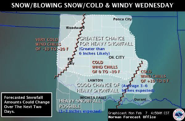
IN OKLAHOMA...HOWEVER...IT LOOKS AS THOUGH THIS FRONTAL STORM
SYSTEM...DESPITE REMAINING OPEN/ NOT DEVELOPING A CLOSED LOW/...
WILL BE A VERY EFFICIENT SNOW PRODUCER. THE TEMPERATURE PROFILES ARE
JUST SO FAVORABLE FOR MODERATE TO HEAVY SNOWFALL...GIVEN THAT THE
COLD AIR IS ALREADY IN PLACE...AND WILL GET COLDER...PLACING A DEEP
LAYER OF -10 TO -20 C AIR COINCIDENT WITH THE STRONGEST LIFT IN THE
CLOUD LAYER. STEEP LAPSE RATES ABOVE 600 MB SHOULD ALSO ENHANCE SNOW
GROWTH IN THE UPPER PART OF THE CLOUD...THUS SEEDING THE REST OF THE
CLOUD WITH NUCLEI FOR GROWTH BY ACCRETION.
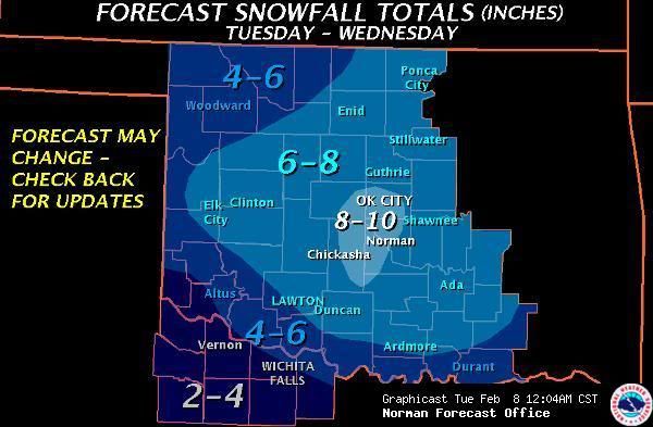
natecast wrote:I've told friends and family here to expect 6-10" of snow in the metro, with an isolated maximum of 12" possible. Latest 12Z GFS is throwing down more QPF and hammers us pretty good, I'll have to wait to see what the Bufkit and snowfall maps look like.
Users browsing this forum: No registered users and 231 guests