Texas Winter 2010-2011

Winter Weather Discussion

Moderator: S2k Moderators

Forum rules

The posts in this forum are NOT official forecast and should not be used as such. They are just the opinion of the poster and may or may not be backed by sound meteorological data. They are NOT endorsed by any professional institution or STORM2K.

Help Support Storm2K
Message
Author
User avatar
Portastorm
Storm2k Moderator
Storm2k Moderator
Posts: 9914
Age: 63
Joined: Fri Jul 11, 2003 9:16 am
Location: Round Rock, TX
Contact:

Re: Texas Winter 2010-2011

#361 Postby Portastorm » Sat Jan 01, 2011 6:41 pm

Today's model trends are encouraging to be certain ... but I'm going to refrain from looking for my kicking shoes and calling Lucy to set up a date for kicking the football until I see a few more days of similar model runs. :wink:

Meanwhile, a nice discussion from Forecaster Cavanaugh out of NWSFO Fort Worth regarding next weekend:

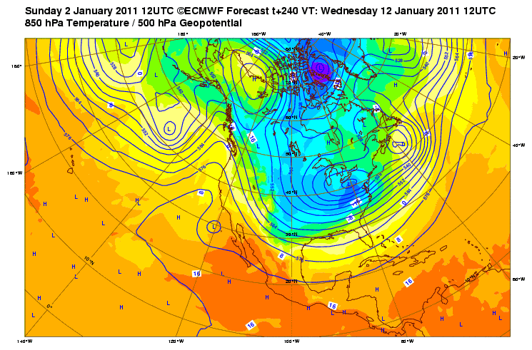
THIS WEEKEND...THE 12Z OPERATIONAL GFS AND ECMWF ARE NOW BOTH
BRINGING THE CUT OFF LOW OFF THE CA/BAJA COAST EAST THRU NEW
MEXICO AND OVER CENTRAL OR SOUTHERN TX FOR THIS WEEKEND. LOOKING
AT THE OPERATIONAL GFS...WHILE THE ENSEMBLE MEAN SUPPORTS IN
GENERAL A WEAK TROUGH OVER THE SOUTHWESTERN CONUS...THE 01/12Z
OPERATIONAL GFS IS THE STRONGEST AND FURTHEST SOUTH OF ALL OF ITS
ENSEMBLE MEMBERS. IT IS POSSIBLE THAT THIS SOLUTION WILL
VERIFY...HOWEVER AS IT CURRENTLY REPRESENTS A RELATIVE OUTLIER
COMPARED TO THE REST OF ITS ENSEMBLE MEMBERS CONFIDENCE IN THIS
PANNING OUT IS CURRENTLY LOW. THE 01/12Z ECMWF ADVERTISING A
SIMILAR SOLUTION IS INTERESTING HOWEVER...SO THIS WEEKEND BEARS
WATCHING VERY CLOSELY AS EITHER OF THESE SCENARIOS WOULD LIKELY
BRING SOME WINTRY PRECIPITATION TO NORTH TX FOR THE FIRST TIME
THIS WINTER. AGAIN...AT THIS TIME CONFIDENCE IN EITHER OF THESE
SOLUTIONS VERIFYING IS CURRENTLY TOO LOW TO INCLUDE A MENTION OF
ANY TYPE OF PRECIPITATION OUT AT DAY 7/8 OF THE FORECAST. WILL
CONTINUE TO MONITOR NEXT WEEKEND CLOSELY IN THE COMING DAYS.
0 likes   

User avatar
Ntxw
Storm2k Moderator
Storm2k Moderator
Posts: 22785
Joined: Wed Oct 21, 2009 6:34 pm
Location: DFW, Texas

Re: Texas Winter 2010-2011

#362 Postby Ntxw » Sat Jan 01, 2011 11:37 pm

Breaking News: Portastorm was unable to infiltrate the 0z GFS therefore still under disappointment winter storm watch for an extreme lack of snow event.

Not all bad, just the usual 0z showing not as cold. Storm is still there and cold nearby, matter of timing. Battle of the heavy weight GFS runs, will 0z or 12z win out?!

Image
Last edited by Ntxw on Sun Jan 02, 2011 12:04 am, edited 1 time in total.
0 likes   
The above post and any post by Ntxw is NOT an official forecast and should not be used as such. It is just the opinion of the poster and may or may not be backed by sound meteorological data. It is NOT endorsed by any professional institution including Storm2k. For official information, please refer to NWS products.

  Help support Storm2K!
Help Support Storm2K

User avatar
srainhoutx
S2K Supporter
S2K Supporter
Posts: 6919
Age: 67
Joined: Sun Jan 14, 2007 11:34 am
Location: Haywood County, NC
Contact:

Re: Texas Winter 2010-2011

#363 Postby srainhoutx » Sat Jan 01, 2011 11:59 pm

Cold front arrives on Thursday/Friday via the GFS. I wouldn't worry about the 'finer' details. The storm is still there. That 1060mb Arctic High in Western Canada and 1050+ in the Northern Rockies has my attention in the 192 hour range. The 00Z GFS show prolonged and reinforcing cold as well as wintry weather across the Lone Star State in the longer range. :wink:
0 likes   
Carla/Alicia/Jerry(In The Eye)/Michelle/Charley/Ivan/Dennis/Katrina/Rita/Wilma/Ike/Harvey

Member: National Weather Association
Wx Infinity Forums
http://wxinfinity.com/index.php

Facebook.com/WeatherInfinity
Twitter @WeatherInfinity

User avatar
iorange55
Category 5
Category 5
Posts: 2388
Joined: Thu Nov 13, 2008 9:47 pm
Location: Big D

Re: Texas Winter 2010-2011

#364 Postby iorange55 » Sun Jan 02, 2011 12:00 am

It does get really cold after that, though. Let's hope the GFS is just a little off track so we get the nice pack of snow and then cold to keep it around.
0 likes   

User avatar
Portastorm
Storm2k Moderator
Storm2k Moderator
Posts: 9914
Age: 63
Joined: Fri Jul 11, 2003 9:16 am
Location: Round Rock, TX
Contact:

Re: Texas Winter 2010-2011

#365 Postby Portastorm » Sun Jan 02, 2011 12:24 am

I'm telling ya, that 0z GFS run code is a real bugger! :lol:

Seriously, while the 0z run doesn't hold the drama we have seen in the last two days' 12z runs ... it doesn't do a "180" either and still is depicting the general picture, as y'all have already pointed out, of a very strong and potent Arctic airmass poised to (and moving) south.
0 likes   

User avatar
Texas Snowman
Storm2k Moderator
Storm2k Moderator
Posts: 6179
Joined: Fri Jan 25, 2008 11:29 am
Location: Denison, Texas

Re: Texas Winter 2010-2011

#366 Postby Texas Snowman » Sun Jan 02, 2011 5:49 am

Fort Worth this morning doesn't seem too hip on wintry weather next weekend.

But they are hip on an arctic blast the following week:

AND FINALLY WE HAVE BEEN SEEING SOME CONSISTENCY TAKE HOLD IN ALL
THE MODELS BEYOND 7 DAYS WITH RESPECT TO A PERIOD OF COLDER THAN
NORMAL WEATHER FOR THE SECOND WEEK OF JANUARY. AN UPPER LEVEL REX
BLOCK OFF GREENLAND/NEWFOUNDLAND HAS BEEN A STAPLE OF THIS
WINTER/S UPPER PATTERN AND HAS RESULTED IN BELOW NORMAL TEMPS IN
THE EASTERN US. THIS BLOCKING FEATURE IS FORECAST TO GRADUALLY
HEAD WESTWARD DURING THE NEXT COUPLE WEEKS...REACHING ALASKA AND
WESTERN CANADA BY 10 DAYS. THIS SHOULD RESULT IN A PROLONGED FETCH
OF CANADIAN AND PERHAPS EVENTUALLY TRUE ARCTIC AIR INTO MUCH OF
THE COUNTRY. TOO EARLY TO OFFER ANY EXACT NUMBERS...BUT THIS MAY
END UP BEING OUR BIGGEST COLD SPELL OF THE 2010-11 WINTER
.
0 likes   
The above post and any post by Texas Snowman is NOT an official forecast and should not be used as such. It is just the opinion of the poster and may or may not be backed by sound meteorological data. It is NOT endorsed by any professional institution including storm2k.org. For official information, please refer to NWS products.

User avatar
Texas Snowman
Storm2k Moderator
Storm2k Moderator
Posts: 6179
Joined: Fri Jan 25, 2008 11:29 am
Location: Denison, Texas

Re: Texas Winter 2010-2011

#367 Postby Texas Snowman » Sun Jan 02, 2011 5:55 am

From OKC this morning:

The plot thickens concerning arctic air and possible wintry weather in about 7-10 days.

From OKC this morning:

WHILE ALL THIS TRANSPIRES... LARGE-SCALE CHANGES WILL TAKE PLACE
ELSEWHERE THAT MAY MOVE THE PIECES INTO PLACE TO SET UP A PERIOD OF
MORE SIGNIFICANT WINTER WEATHER EARLY NEXT WEEK... AND POSSIBLY AS
EARLY AS NEXT SATURDAY.
POSITIVE HEIGHT ANOMALIES OVER S GREENLAND
BUILD W ACROSS N CANADA WHILE NEGATIVE ANOMALIES DO LIKEWISE FARTHER
S NEAR THE LATITUDE OF THE US-CANADA BORDER. LATTER LEADS TO AN
UPPER LOW ANCHORING OVER THE WA/BC AREA BY NEXT WEEKEND... AND
STRENGTHENING OF THE WESTERLIES ACROSS THE CONUS. MEANWHILE AN UPPER
LOW DEVELOPS OFF THE S CA COAST... IN THE S PART OF THE
AFOREMENTIONED W-COAST SPLIT FLOW PATTERN. THIS SYSTEM WILL MOVE E
LATER IN THE WEEK BUT TIMING DIFFERENCES EXIST AMONG THE MED-RANGE
MODELS. THE STRONGER WESTERLIES BY THEN MIGHT GIVE A NOD TO THE
FASTER ECMWF... IN WHICH CASE PRECIP WOULD ARRIVE HERE BY NEXT
SATURDAY. LOW POPS ARE THUS BEING INTRODUCED NEXT WEEKEND.

THEN THERE IS THE ARCTIC AIR. MODELS CONTINUE TO BUILD A STRONG
HIGH-LATITUDE RIDGE AROUND 150-160W BY WEEKS END... WHICH IN TANDEM
WITH THE ABOVE-NORMAL HEIGHTS OVER N CANADA WILL SUPPORT A BUILDUP
OF COLD AIR OVER W CANADA BY NEXT WEEKEND. SOME OF THIS AIR WILL
OOZE/TRICKLE S INTO THE CENTRAL/EASTERN CONUS BY THE END OF THE
WEEK... LEADING TO A COOLING TREND FRIDAY AND BEYOND. IF ENOUGH OF
IT BECOMES ESTABLISHED THIS FAR S... WE COULD BE LOOKING AT A WINTER
PRECIP EVENT NEXT WEEKEND AS THE LATE-WEEK SYSTEM MOVES E ACROSS
TX/OK. MORE COLD AIR IS LIKELY TO MOVE S IN THE WAKE OF THIS
SYSTEM... AND THERE SHOULD BE PLENTY OF IT TO TAP INTO BY THEN TO
OUR N.


NOTE THAT BOTH THE 00Z GFS AND THE 00Z ECMWF HAVE A 500-MB HIGH OF
AROUND 580HPA OVER ALASKA BY TUE 11 JAN. NOT A GOOD SIGN - NASTY
THINGS USUALLY HAPPEN IN TERMS OF COLD AND SNOW/ICE IN PATTERNS LIKE
THIS... NOT ONLY AROUND HERE BUT IN MANY PARTS OF THE LOWER 48. NEXT
WEEK MAY BE INTERESTING IN A NUMBER OF WAYS.
0 likes   
The above post and any post by Texas Snowman is NOT an official forecast and should not be used as such. It is just the opinion of the poster and may or may not be backed by sound meteorological data. It is NOT endorsed by any professional institution including storm2k.org. For official information, please refer to NWS products.

User avatar
Portastorm
Storm2k Moderator
Storm2k Moderator
Posts: 9914
Age: 63
Joined: Fri Jul 11, 2003 9:16 am
Location: Round Rock, TX
Contact:

Re: Texas Winter 2010-2011

#368 Postby Portastorm » Sun Jan 02, 2011 12:08 pm

Thanks for the clip, Snowman. The guys at OKC are sharp with winter weather. Good to know their thoughts.

Well boys and girls, the 12z GFS is showing more of the same (1063 mb high in Western Canada, anyone?) ... things start to get crazy next weekend and beyond. Buckle your seatbelts!
0 likes   

User avatar
iorange55
Category 5
Category 5
Posts: 2388
Joined: Thu Nov 13, 2008 9:47 pm
Location: Big D

Re: Texas Winter 2010-2011

#369 Postby iorange55 » Sun Jan 02, 2011 12:10 pm

Yeah still showing a lot of cold but, I don't like the trend showing no storm now and it seems to be pushing the cold back some. Usually when that happens it progressively gets warmer.
0 likes   

User avatar
Portastorm
Storm2k Moderator
Storm2k Moderator
Posts: 9914
Age: 63
Joined: Fri Jul 11, 2003 9:16 am
Location: Round Rock, TX
Contact:

Re: Texas Winter 2010-2011

#370 Postby Portastorm » Sun Jan 02, 2011 12:17 pm

iorange55 wrote:Yeah still showing a lot of cold but, I don't like the trend showing no storm now and it seems to be pushing the cold back some. Usually when that happens it progressively gets warmer.


Maybe I'm looking at this through snow-colored glasses ... but I think that is more an issue of the GFS not handling the Arctic air well. When you get those 1050-1060 mb highs sliding down into Western Canada, unless you have some kind of firehose jet stream from the Pacific holding the air at bay, that air is gonna come south along the leeside of the Rockies. Right now, the Pacific jet ain't all that strong!

As far as vorticity/storms go, yeah ... hard to say right now. It would be nice to see some disturbances roll through to maximize our "vodka cold" and give us some wintry fun. But I do feel more confident that we're going to see some major-league cold in the next 7-10 days.

One thing I remember Wxman57 teaching us a few winters back ... in situations like this, with the GFS, pay more attention to the source regions for the where the air is coming from and the progged 500mb flow. That will tell you more than the surface depictions from the GFS sometimes.
0 likes   

User avatar
srainhoutx
S2K Supporter
S2K Supporter
Posts: 6919
Age: 67
Joined: Sun Jan 14, 2007 11:34 am
Location: Haywood County, NC
Contact:

Re: Texas Winter 2010-2011

#371 Postby srainhoutx » Sun Jan 02, 2011 12:25 pm

The source region is Siberia and a cross Polar flow becomes well established in the longer range. This will likely not be a 1-2 event, IMO. A bit different view via the 12Z GFS may help. :wink:

Image
0 likes   
Carla/Alicia/Jerry(In The Eye)/Michelle/Charley/Ivan/Dennis/Katrina/Rita/Wilma/Ike/Harvey

Member: National Weather Association
Wx Infinity Forums
http://wxinfinity.com/index.php

Facebook.com/WeatherInfinity
Twitter @WeatherInfinity

User avatar
Ntxw
Storm2k Moderator
Storm2k Moderator
Posts: 22785
Joined: Wed Oct 21, 2009 6:34 pm
Location: DFW, Texas

Re: Texas Winter 2010-2011

#372 Postby Ntxw » Sun Jan 02, 2011 12:26 pm

Hmm, impressive HP. I'm not so worried about the storm it will work itself out in time. We couldn't possibly expect the GFS to keep it stagnant 200 hours out :lol: . Just a few days ago the models were showing zonal flow with nothing to look at, big flip since then.

Watch, just because the GFS is weakening it I bet the Euro will show a bomb :lol: :lol: :wink:
0 likes   
The above post and any post by Ntxw is NOT an official forecast and should not be used as such. It is just the opinion of the poster and may or may not be backed by sound meteorological data. It is NOT endorsed by any professional institution including Storm2k. For official information, please refer to NWS products.


  Help support Storm2K!

Help Support Storm2K


User avatar
somethingfunny
ChatStaff
ChatStaff
Posts: 3926
Age: 37
Joined: Thu May 31, 2007 10:30 pm
Location: McKinney, Texas

Re: Texas Winter 2010-2011

#373 Postby somethingfunny » Sun Jan 02, 2011 1:17 pm

iorange55 wrote:If none of this comes together then it's official that this winter is a tease.


Oh it'll be cold. :wink:
0 likes   
I am not a meteorologist, and any posts made by me are not official forecasts or to be interpreted as being intelligent. These posts are just my opinions and are probably silly opinions.

Dustan78
Tropical Depression
Tropical Depression
Posts: 62
Age: 46
Joined: Mon Feb 08, 2010 8:52 pm
Location: Fort Worth, TX

Re: Texas Winter 2010-2011

#374 Postby Dustan78 » Sun Jan 02, 2011 1:27 pm

How cold are we talking in Fort Worth? I hate when its brutaly cold with no snow!
0 likes   

User avatar
Portastorm
Storm2k Moderator
Storm2k Moderator
Posts: 9914
Age: 63
Joined: Fri Jul 11, 2003 9:16 am
Location: Round Rock, TX
Contact:

Re: Texas Winter 2010-2011

#375 Postby Portastorm » Sun Jan 02, 2011 1:38 pm

Dustan78 wrote:How cold are we talking in Fort Worth? I hate when its brutaly cold with no snow!


IMHO, sub-freezing high temps for a day or two wouldn't be out of the question. Maybe more if this pattern delivers.
0 likes   

User avatar
srainhoutx
S2K Supporter
S2K Supporter
Posts: 6919
Age: 67
Joined: Sun Jan 14, 2007 11:34 am
Location: Haywood County, NC
Contact:

Re: Texas Winter 2010-2011

#376 Postby srainhoutx » Sun Jan 02, 2011 2:00 pm

The 12Z Euro continues the trend and suggests a classic Arctic outbreak signature @ hour 240.

Image
0 likes   
Carla/Alicia/Jerry(In The Eye)/Michelle/Charley/Ivan/Dennis/Katrina/Rita/Wilma/Ike/Harvey

Member: National Weather Association
Wx Infinity Forums
http://wxinfinity.com/index.php

Facebook.com/WeatherInfinity
Twitter @WeatherInfinity

User avatar
Portastorm
Storm2k Moderator
Storm2k Moderator
Posts: 9914
Age: 63
Joined: Fri Jul 11, 2003 9:16 am
Location: Round Rock, TX
Contact:

Re: Texas Winter 2010-2011

#377 Postby Portastorm » Sun Jan 02, 2011 2:06 pm

srainhoutx wrote:The 12Z Euro continues the trend and suggests a classic Arctic outbreak signature @ hour 240.

[img]Image[/img]


OMG! :eek:

Check out the 500mb and 850 mb flow at 240 hours ... thar she blows!!

http://www.meteo.psu.edu/~gadomski/ECMWF0.5_12z/ecmwfloop.html
0 likes   

User avatar
srainhoutx
S2K Supporter
S2K Supporter
Posts: 6919
Age: 67
Joined: Sun Jan 14, 2007 11:34 am
Location: Haywood County, NC
Contact:

Re: Texas Winter 2010-2011

#378 Postby srainhoutx » Sun Jan 02, 2011 2:16 pm

Just stunning to see such consistency via guidance. :cheesy:

Image
0 likes   
Carla/Alicia/Jerry(In The Eye)/Michelle/Charley/Ivan/Dennis/Katrina/Rita/Wilma/Ike/Harvey

Member: National Weather Association
Wx Infinity Forums
http://wxinfinity.com/index.php

Facebook.com/WeatherInfinity
Twitter @WeatherInfinity

User avatar
Ntxw
Storm2k Moderator
Storm2k Moderator
Posts: 22785
Joined: Wed Oct 21, 2009 6:34 pm
Location: DFW, Texas

Re: Texas Winter 2010-2011

#379 Postby Ntxw » Sun Jan 02, 2011 2:17 pm

Looks like the pattern is ripe lee side of the rockies. Nothing but barbed wire holding it back. Stunning how this La Nada is getting slapped around at times. Hopefully there will be a snowcover just before the arctic arrives. Fun stretch if there was. I'd be shocked if we go through the entire period unscathed, without wintry precipitation.

JB sure seems to think the battle zone is shifting south into TX, as far as storms go.
0 likes   
The above post and any post by Ntxw is NOT an official forecast and should not be used as such. It is just the opinion of the poster and may or may not be backed by sound meteorological data. It is NOT endorsed by any professional institution including Storm2k. For official information, please refer to NWS products.


  Help support Storm2K!

Help Support Storm2K


Dustan78
Tropical Depression
Tropical Depression
Posts: 62
Age: 46
Joined: Mon Feb 08, 2010 8:52 pm
Location: Fort Worth, TX

Re: Texas Winter 2010-2011

#380 Postby Dustan78 » Sun Jan 02, 2011 2:24 pm

Portastorm wrote:
Dustan78 wrote:How cold are we talking in Fort Worth? I hate when its brutaly cold with no snow!


IMHO, sub-freezing high temps for a day or two wouldn't be out of the question. Maybe more if this pattern delivers.


Wow! When was it last year, it got really cold, below freezing for two or three days, with no snow?
0 likes   


Return to “Winter Weather”

Who is online

Users browsing this forum: No registered users and 11 guests