Winter 2010-11 for the Southern Plains

Winter Weather Discussion

Moderator: S2k Moderators

Forum rules

The posts in this forum are NOT official forecast and should not be used as such. They are just the opinion of the poster and may or may not be backed by sound meteorological data. They are NOT endorsed by any professional institution or STORM2K.

Help Support Storm2K
Message
Author
User avatar
Extremeweatherguy
Category 5
Category 5
Posts: 11095
Joined: Mon Oct 10, 2005 8:13 pm
Location: Florida

Re: Winter 2010-11 for the Southern Plains

#261 Postby Extremeweatherguy » Sun Nov 21, 2010 10:06 pm

Below is a comparison of the 12z ECMWF, 00z NAM and 00z GFS surface cold front locations for Thanksgiving morning...

12z ECMWF - valid 6am Thursday morning
Image

00z GFS - valid 6am Thursday morning
Image

00z NAM - valid 6am Thursday morning
Image

The 12z ECMWF and 00z GFS are remarkably similar, while the 00z NAM looks way too slow.

please note that I have not posted all the fronts on the maps, only the cold front section that I have deemed most important to our weather across the southern plains.
Last edited by Extremeweatherguy on Sun Nov 21, 2010 11:28 pm, edited 1 time in total.
0 likes   

User avatar
srainhoutx
S2K Supporter
S2K Supporter
Posts: 6919
Age: 67
Joined: Sun Jan 14, 2007 11:34 am
Location: Haywood County, NC
Contact:

Re: Winter 2010-11 for the Southern Plains

#262 Postby srainhoutx » Mon Nov 22, 2010 9:49 am

Not to get too far ahead of ourselves, but the end of November/first of December is beginning to look mighty cold. Perhaps even colder than what we will see for Thanksgiving. Stay Tuned, as they say...

Image
0 likes   
Carla/Alicia/Jerry(In The Eye)/Michelle/Charley/Ivan/Dennis/Katrina/Rita/Wilma/Ike/Harvey

Member: National Weather Association
Wx Infinity Forums
http://wxinfinity.com/index.php

Facebook.com/WeatherInfinity
Twitter @WeatherInfinity

HockeyTx82
S2K Supporter
S2K Supporter
Posts: 2540
Joined: Tue Oct 27, 2009 11:17 am
Location: Ponder, TX

Re: Winter 2010-11 for the Southern Plains

#263 Postby HockeyTx82 » Mon Nov 22, 2010 10:17 am

:eek:

We have a tree lighting on the square here in Denton on the 2nd of December so I will be watching the boards very close over the next week or two. :cold:
0 likes   
Don't hold me accountable for anything I post on this forum. Leave the real forecasting up to the professionals.

Location: Ponder, TX (all observation posts are this location unless otherwise noted)

User avatar
Extremeweatherguy
Category 5
Category 5
Posts: 11095
Joined: Mon Oct 10, 2005 8:13 pm
Location: Florida

Re: Winter 2010-11 for the Southern Plains

#264 Postby Extremeweatherguy » Mon Nov 22, 2010 6:42 pm

Hmm; anyone notice that the models are starting to get more aggressive with the idea of overrunning precipitation (snow) Thanksgiving day across northeast OK up through MO?

Check out the 18z NAM:

http://www.twisterdata.com/index.php?pr ... hive=false

We will have to watch this possibility closely for northeastern parts of the southern plains
0 likes   

User avatar
TwisterFanatic
Category 5
Category 5
Posts: 1041
Joined: Mon Jun 28, 2010 12:43 pm
Location: Sallisaw, Oklahoma

#265 Postby TwisterFanatic » Tue Nov 23, 2010 1:09 am

The weatherman mentioned that during the 10 o'clock newscast tonight.
0 likes   
Personal Forecast Disclaimer:
The posts in this forum are NOT official forecast and should not be used as such. They are just the opinion of the poster and may or may not be backed by sound meteorological data. They are NOT endorsed by any professional institution or storm2k.org. For official information, please refer to the NHC and NWS products.

User avatar
Ntxw
Storm2k Moderator
Storm2k Moderator
Posts: 22784
Joined: Wed Oct 21, 2009 6:34 pm
Location: DFW, Texas

Re: Winter 2010-11 for the Southern Plains

#266 Postby Ntxw » Tue Nov 23, 2010 1:54 pm

For future interests (next shot of cold air advertised next week), there is more snow cover in states/southern Canada at this time vs last year in the same period.

I used the data on the 21st of this year being that it doesn't have current data in for the 22nd or 23rd.

Image
0 likes   
The above post and any post by Ntxw is NOT an official forecast and should not be used as such. It is just the opinion of the poster and may or may not be backed by sound meteorological data. It is NOT endorsed by any professional institution including Storm2k. For official information, please refer to NWS products.

  Help support Storm2K!
Help Support Storm2K

orangeblood
S2K Supporter
S2K Supporter
Posts: 3714
Joined: Tue Dec 15, 2009 6:14 pm
Location: Fort Worth, TX

Re: Winter 2010-11 for the Southern Plains

#267 Postby orangeblood » Tue Nov 23, 2010 3:24 pm

According to the European and Canadian models, it appears the Late Sunday - Tuesday timeframe next week is starting to look really interesting for wintry precip across the Southern Plains. With cold air draped across the northern US and energy coming out of the southwest, the setup has the potential for the first winter storm of the season across the Southern plains early next week.
0 likes   

User avatar
wall_cloud
Professional-Met
Professional-Met
Posts: 401
Age: 48
Joined: Sun Dec 04, 2005 7:32 am
Location: Bartlett, TN
Contact:

Re: Winter 2010-11 for the Southern Plains

#268 Postby wall_cloud » Tue Nov 23, 2010 3:42 pm

if the moisture can return in time. this Thanksgiving front is going to scour the moisture well south of the area.
0 likes   
My comments are my own and do not reflect those of NOAA or the National Weather Service.

User avatar
Ntxw
Storm2k Moderator
Storm2k Moderator
Posts: 22784
Joined: Wed Oct 21, 2009 6:34 pm
Location: DFW, Texas

Re: Winter 2010-11 for the Southern Plains

#269 Postby Ntxw » Tue Nov 23, 2010 4:25 pm

wall_cloud wrote:if the moisture can return in time. this Thanksgiving front is going to scour the moisture well south of the area.


I don't think it will recover in time even with a system nearby. Sure do miss that SJT...
0 likes   
The above post and any post by Ntxw is NOT an official forecast and should not be used as such. It is just the opinion of the poster and may or may not be backed by sound meteorological data. It is NOT endorsed by any professional institution including Storm2k. For official information, please refer to NWS products.


  Help support Storm2K!

Help Support Storm2K


User avatar
srainhoutx
S2K Supporter
S2K Supporter
Posts: 6919
Age: 67
Joined: Sun Jan 14, 2007 11:34 am
Location: Haywood County, NC
Contact:

Re: Winter 2010-11 for the Southern Plains

#270 Postby srainhoutx » Tue Nov 23, 2010 4:29 pm

Another great disco from Dodge City, KC...

DAYS 1-2...

THE MAIN FORECAST CHALLENGE IS THE TIMING AND SPEED OF THE POTENT
AND IMMINENT COLD FRONT TOMORROW.

FOR TONIGHT, DID NOT CHANGE MUCH. HOWEVER, SINCE THE HYS AREA HAS
REMAINED SOCKED IN ALL DAY TODAY, AND A SOUTHEASTERLY UPSLOPE
FLOW WILL HELP LOW LEVEL MOISTURE RIDE UP IN THE CENTRAL KANSAS
OVERNIGHT, INTRODUCED AREAS OF FOG IN OUR NORTHEAST ZONES AND
PATCHY FOG WORDING IN OUR SOUTHEAST AREAS. SOUTH TO SOUTHEAST WINDS
WILL BE 10 TO 20 MPH EARLY AND BECOME LIGHT AFTER MIDNIGHT. CLOUDS
ARE NOT EXPECTED, EXCEPT NORTH OF I-70 IN HAYS AND WAKEENEY AREAS,
AS PREVIOUSLY MENTIONED. MINIMUM TEMPS WILL BE TRICKY FOR ANY
AREAS THAT MIGHT GET FOG, BUT WENT WITH THE WARMEST MINS IN THE
SOUTHEAST NEAR P28 WITH 41F, AND DOWN TO AS LOW AS 31F IN THE EHA
AREA, WHERE NO CLOUDS AND LIGHT WINDS (UNTIL LATE) SHOULD ALLOW
FOR RAPID COOLING THIS EVENING IN MY WEST AND A STEADY FALL
OVERNIGHT.

WHEN COMPARING THE NAM, RUC, GFS, GEM AND ECMWF MODELS, IT APPEARS
THE FRONT WOULD ENTER OUT CWA ABOUT 15Z WEDNESDAY IN THE
NORTHWEST, ABOUT 18Z IN GCK, 19Z IN THE DDC AND BY 22Z OR SO IN
OUR SOUTHEASTERN CWA. BUT, KNOWING THE SPEED OF COLD AIR CAN OFTEN
MOVE SOUTH THROUGH THE CWA MUCH FASTER THAN DEPICTED IN THE
MODELS, HAVE OPTED TO BRING THE FRONT THROUGH 2-4 HOURS FASTER,
AND STILL FASTER IN OUR FAR WESTERN ZONES. COLD AIR CAN PLUNGE
SOUTH THROUGH THE PLAINS WITH LITTLE OR NO RESISTANCE. SO ALSO
LOWER MAX TEMPS IN MY WESTERN ZONES WEDNESDAY, DUE TO THE EXPECTED
SOUTHERN PLUNGE OF THE COLD FRONT. WILL ALSO HAVE FALLING DAY TIME
TEMPS AFTER THE FROPA WEDNESDAY AFTERNOON. SINCE OUR WESTERN 1/3RD
OF THE CWA HAS BEEN WITHOUT PRECIP IN SO LONG, THEY ARE PRIME FOR
ANY WILDFIRES THAT MAY GENERATE. SO, WILL BE ISSUEING A FIRE
WEATHER WATCH FROM 10AM - 3PM WED, UNTIL THE FRONT PASSES THROUGH
THERE. FURTHERMORE, I CONSIDERED MENTION FLURRIES WITH THIS FAST
CHARGING COLD FRONT. BUT SINCE NO MODEL GENERATURES PRECIP AS THE
FRONT CROSSES OUR CWA, HAVE OPTED TO LEAVE ANY POPS OUT AT THIS TIME.


ALL MODELS BRING THE COLD AIR THROUGH AND PUSH IT FAR SOUTHWARD INTO
OKLAHOMA AND TEXAS WEDNESDAY NIGHT. THIS SHOULD BRING THE COLDEST
NIGHT OF THE SEASON FOR ALL OF OUR CWA. TEMPS SHOULD TUMBLE
WEDNESDAY NIGHT INTO 10F (GCK) TO 20F (P28) RANGE. WINDS WILL START
OUT IN THE 10 TO 20 MPH RANGE FROM THE NORTH, AND SHOULD BE FAIRLY
LIGHT TOWARD THANKSGIVING MORNING AS HIGH PRESSURE WILL BE BUILDING
IN FROM THE NORTHWEST. WIND CHILLS READINGS WILL DIP TO AROUND -7F
AROUND SUNRISE THURSDAY MORNING.
EVEN THOUGH LITTLE OR NO CLOUDS ARE
EXPECTED THURSDAY, STILL THINK TEMPERATURES WILL STRUGGLE TO CLIMB
WITHIN THIS POLAR AIR MASS. DID NOT CHANGE ANY OF THANKSGIVINGS` MAX
T`S, LEAVING THEM IN THE 30F (HYS) TO 36F (P28) RANGE. /BURKE
0 likes   
Carla/Alicia/Jerry(In The Eye)/Michelle/Charley/Ivan/Dennis/Katrina/Rita/Wilma/Ike/Harvey

Member: National Weather Association
Wx Infinity Forums
http://wxinfinity.com/index.php

Facebook.com/WeatherInfinity
Twitter @WeatherInfinity

User avatar
TwisterFanatic
Category 5
Category 5
Posts: 1041
Joined: Mon Jun 28, 2010 12:43 pm
Location: Sallisaw, Oklahoma

Re: Winter 2010-11 for the Southern Plains

#271 Postby TwisterFanatic » Tue Nov 23, 2010 4:33 pm

Very interesting forecast maybe setting up early next week. This is from the Tulsa NWS for Sallisaw, Oklahoma.

Sunday: Sunny, with a high near 57.

Sunday Night: A slight chance of rain. Partly cloudy, with a low around 42.

Monday: A chance of rain. Mostly sunny, with a high near 62.

Monday Night: A chance of rain and snow. Clear, with a low around 30.

Tuesday: A slight chance of rain and snow. Sunny, with a high near 49.
0 likes   
Personal Forecast Disclaimer:
The posts in this forum are NOT official forecast and should not be used as such. They are just the opinion of the poster and may or may not be backed by sound meteorological data. They are NOT endorsed by any professional institution or storm2k.org. For official information, please refer to the NHC and NWS products.

User avatar
Ntxw
Storm2k Moderator
Storm2k Moderator
Posts: 22784
Joined: Wed Oct 21, 2009 6:34 pm
Location: DFW, Texas

Re: Winter 2010-11 for the Southern Plains

#272 Postby Ntxw » Tue Nov 23, 2010 7:09 pm

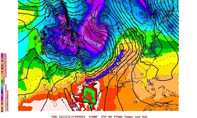
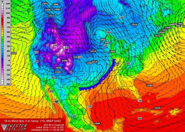
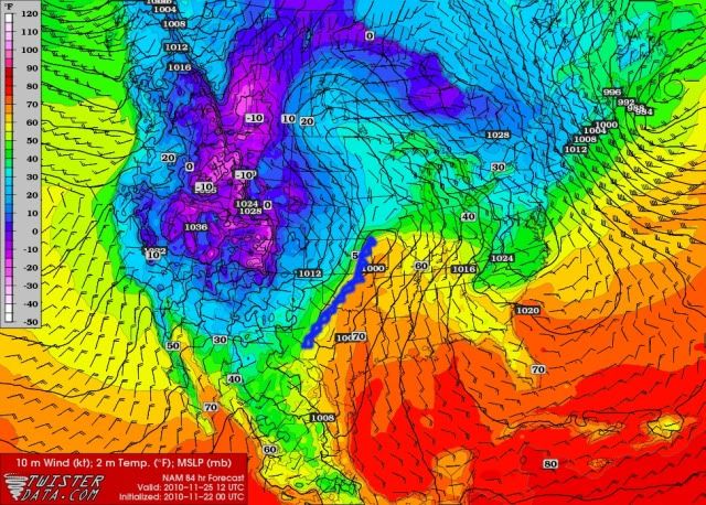
Today's forecasts for Thanksgivings around the southern plains, plan accordingly ;).

OKC

Thanksgiving Day: Mostly cloudy, with a high near 40. North northwest wind between 13 and 18 mph, with gusts as high as 25 mph.

DFW

Thanksgiving Day: Showers likely and possibly a thunderstorm before noon. Cloudy, with a temperature falling to around 38 by noon. Windy, with a north northwest wind 10 to 15 mph increasing to between 20 and 25 mph. Winds could gust as high as 30 mph. Chance of precipitation is 60%.

Houston

Thanksgiving Day: A 30 percent chance of showers and thunderstorms, mainly after noon. Mostly cloudy, with a high near 80. South wind 10 to 15 mph becoming west.

Thursday Night: A 50 percent chance of showers and thunderstorms. Mostly cloudy, with a low around 43. Breezy, with a north wind between 10 and 20 mph.

Austin/SA

Thanksgiving Day: A 40 percent chance of showers and thunderstorms. Cloudy, with a high near 70. North northwest wind between 10 and 20 mph, with gusts as high as 25 mph.

Thursday Night: Mostly cloudy, with a low around 34. North wind between 10 and 20 mph, with gusts as high as 25 mph.

Amarillo

Thanksgiving Day: Mostly sunny, with a high near 34. Wind chill values between 2 and 12. North northeast wind between 5 and 15 mph, with gusts as high as 20 mph.
0 likes   
The above post and any post by Ntxw is NOT an official forecast and should not be used as such. It is just the opinion of the poster and may or may not be backed by sound meteorological data. It is NOT endorsed by any professional institution including Storm2k. For official information, please refer to NWS products.


  Help support Storm2K!

Help Support Storm2K


User avatar
srainhoutx
S2K Supporter
S2K Supporter
Posts: 6919
Age: 67
Joined: Sun Jan 14, 2007 11:34 am
Location: Haywood County, NC
Contact:

Re: Winter 2010-11 for the Southern Plains

#273 Postby srainhoutx » Wed Nov 24, 2010 9:21 am

La La Land 06Z GFS should start some chatter around here... :double: :cheesy:

Image
0 likes   
Carla/Alicia/Jerry(In The Eye)/Michelle/Charley/Ivan/Dennis/Katrina/Rita/Wilma/Ike/Harvey

Member: National Weather Association
Wx Infinity Forums
http://wxinfinity.com/index.php

Facebook.com/WeatherInfinity
Twitter @WeatherInfinity

User avatar
Ntxw
Storm2k Moderator
Storm2k Moderator
Posts: 22784
Joined: Wed Oct 21, 2009 6:34 pm
Location: DFW, Texas

Re: Winter 2010-11 for the Southern Plains

#274 Postby Ntxw » Wed Nov 24, 2010 3:20 pm

ImageImage

Knocking on the doorstep of the southern plains.
0 likes   
The above post and any post by Ntxw is NOT an official forecast and should not be used as such. It is just the opinion of the poster and may or may not be backed by sound meteorological data. It is NOT endorsed by any professional institution including Storm2k. For official information, please refer to NWS products.


  Help support Storm2K!

Help Support Storm2K


User avatar
srainhoutx
S2K Supporter
S2K Supporter
Posts: 6919
Age: 67
Joined: Sun Jan 14, 2007 11:34 am
Location: Haywood County, NC
Contact:

Re: Winter 2010-11 for the Southern Plains

#275 Postby srainhoutx » Wed Nov 24, 2010 3:24 pm

Front just passed Liberal, KS. Heading into NW OK at this time.
0 likes   
Carla/Alicia/Jerry(In The Eye)/Michelle/Charley/Ivan/Dennis/Katrina/Rita/Wilma/Ike/Harvey

Member: National Weather Association
Wx Infinity Forums
http://wxinfinity.com/index.php

Facebook.com/WeatherInfinity
Twitter @WeatherInfinity

kb75007
Tropical Storm
Tropical Storm
Posts: 141
Joined: Sat Nov 20, 2010 4:03 pm
Location: Lewisville, Texas

#276 Postby kb75007 » Wed Nov 24, 2010 4:28 pm

I read the other day on here that the temp. tomorrow for dallas would drop to 38 by noon. :cold: Is this still right? What are the temps. looking like for tomorrow? I've heard multiple different things!
Thanks
0 likes   

User avatar
TwisterFanatic
Category 5
Category 5
Posts: 1041
Joined: Mon Jun 28, 2010 12:43 pm
Location: Sallisaw, Oklahoma

#277 Postby TwisterFanatic » Wed Nov 24, 2010 4:34 pm

Weather Channel now saying Winter Mix tomorrow during the afternoon in my area.
0 likes   
Personal Forecast Disclaimer:
The posts in this forum are NOT official forecast and should not be used as such. They are just the opinion of the poster and may or may not be backed by sound meteorological data. They are NOT endorsed by any professional institution or storm2k.org. For official information, please refer to the NHC and NWS products.

User avatar
somethingfunny
ChatStaff
ChatStaff
Posts: 3926
Age: 37
Joined: Thu May 31, 2007 10:30 pm
Location: McKinney, Texas

Re: Winter 2010-11 for the Southern Plains

#278 Postby somethingfunny » Thu Nov 25, 2010 1:59 am

Take a trip down US 287 tonight....


Rick Husband Amarillo Intl Airport
Lat: 35.23 Lon: -101.7 Elev: 3586
Last Update on Nov 24, 11:53 pm CST

Fair and Breezy

28 °F (-2 °C)
Humidity:72 %
Wind Speed:N 22 MPH
Barometer:29.83" (1008.4 mb)
Dewpoint:20 °F (-7 °C)
Wind Chill:14 °F (-10 °C)
Visibility:10.00 mi.


Childress Municipal Airport
Lat: 34.44 Lon: -100.28 Elev: 1951
Last Update on Nov 24, 11:53 pm CST

Fair and Breezy

45 °F (7 °C)
Humidity:58 %
Wind Speed:N 23 MPH
Barometer:29.77" (1006.8 mb)
Dewpoint:31 °F (-1 °C)
Wind Chill:36 °F (2 °C)
Visibility:10.00 mi.


Vernon
Lat: 34.23 Lon: -99.28 Elev: 1266
Last Update on Nov 25, 12:25 am CST

Fair and Breezy

49 °F (9 °C)
Humidity:60 %
Wind Speed:N 21 G 30 MPH
Barometer:29.74"
Dewpoint:36 °F (2 °C)
Wind Chill:42 °F (6 °C)
Visibility:10.00 mi.


Wichita Falls, Sheppard Air Force Base
Lat: 33.98 Lon: -98.48 Elev: 1027
Last Update on Nov 24, 11:52 pm CST

Fair

68 °F (20 °C)
Humidity:61 %
Wind Speed:SW 9 MPH
Barometer:29.65" (1002.9 mb)
Dewpoint:54 °F (12 °C)
Visibility:10.00 mi.


Decatur Municipal Airport
Lat: 33.26 Lon: -97.58 Elev: 1047
Last Update on Nov 25, 12:25 am CST

Fair

70 °F (21 °C)
Humidity:79 %
Wind Speed:S 10 G 20 MPH
Barometer:29.69"
Dewpoint:63 °F (17 °C)
Visibility:10.00 mi.


Dallas / Addison Airport
Lat: 32.98 Lon: -96.83 Elev: 643
Last Update on Nov 25, 12:24 am CST

Partly Cloudy

74 °F (24 °C)
Humidity:74 %
Wind Speed:S 12 G 22 MPH
Barometer:29.70"
Dewpoint:65 °F (19 °C)
Visibility:10.00 mi


It's coming. You can even see the front's wind shift on radar near Wichita Falls stretching to north of Ardmore right now. The storms don't begin to fire until McAlester - I'm beginning to think that the rain will bypass us here in Dallas.
0 likes   
I am not a meteorologist, and any posts made by me are not official forecasts or to be interpreted as being intelligent. These posts are just my opinions and are probably silly opinions.

User avatar
Portastorm
Storm2k Moderator
Storm2k Moderator
Posts: 9914
Age: 63
Joined: Fri Jul 11, 2003 9:16 am
Location: Round Rock, TX
Contact:

Re: Winter 2010-11 for the Southern Plains

#279 Postby Portastorm » Thu Nov 25, 2010 7:40 am

Good morning and Happy Thanksgiving!

At 6:30 am, looks like the polar front is stretched from Amarillo to just west of the Metroplex. 12 degrees in Dalhart at the moment ... bbrrrr!!! :cold:

Image

Uploaded with ImageShack.us
0 likes   

HockeyTx82
S2K Supporter
S2K Supporter
Posts: 2540
Joined: Tue Oct 27, 2009 11:17 am
Location: Ponder, TX

Re: Winter 2010-11 for the Southern Plains

#280 Postby HockeyTx82 » Thu Nov 25, 2010 8:46 am

Anyone see this coming?

URGENT - WINTER WEATHER MESSAGE
NATIONAL WEATHER SERVICE NORMAN OK
740 AM CST THU NOV 25 2010

OKZ031-032-039>048-050>052-TXZ086-089-090-251800-
/O.NEW.KOUN.WW.Y.0013.101125T1340Z-101125T1800Z/
SEMINOLE-HUGHES-STEPHENS-GARVIN-MURRAY-PONTOTOC-COAL-COTTON-
JEFFERSON-CARTER-JOHNSTON-ATOKA-LOVE-MARSHALL-BRYAN-WICHITA-
ARCHER-CLAY-
INCLUDING THE CITIES OF...SEMINOLE...HOLDENVILLE...DUNCAN...
PAULS VALLEY...SULPHUR...ADA...COALGATE...WALTERS...WAURIKA...
ARDMORE...TISHOMINGO...ATOKA...MARIETTA...MADILL...DURANT...
WICHITA FALLS...ARCHER CITY...HOLLIDAY...LAKESIDE CITY...
HENRIETTA
740 AM CST THU NOV 25 2010

...WINTER WEATHER ADVISORY IN EFFECT UNTIL NOON CST TODAY...

THE NATIONAL WEATHER SERVICE IN NORMAN HAS ISSUED A WINTER
WEATHER ADVISORY FOR FREEZING RAIN WHICH IS IN EFFECT UNTIL NOON
CST TODAY.

* A BAND OF LIGHT TO MODERATE FREEZING RAIN WILL MOVE ACROSS
SOUTHERN OKLAHOMA THIS MORNING AND EARLY AFTERNOON. A FEW
THUNDER SHOWERS WILL ALSO BE POSSIBLE. TEMPERATURES WILL HOVER
NEAR THE FREEZING MARK THROUGH THE LATE MORNING HOURS.


* MAIN IMPACT.. A LIGHT GLAZE OF ICE IS POSSIBLE ON EXPOSED
SURFACES...TREES AND POWER LINES AND VEHICLES. MOST ROADWAYS
WILL REMAIN WET...BUT BRIDGES AND OVERPASSES MAY BECOME SLICK.


PRECAUTIONARY/PREPAREDNESS ACTIONS...

PRECAUTIONARY/PREPAREDNESS ACTIONS...
* USE EXTRA CAUTION WHEN DRIVING TODAY DUE TO THE EXPECTED
VARIABILITY IN ROAD CONDITIONS. BE PREPARED FOR SLIPPERY
CONDITIONS ON BRIDGES AND OVERPASSES.
0 likes   
Don't hold me accountable for anything I post on this forum. Leave the real forecasting up to the professionals.

Location: Ponder, TX (all observation posts are this location unless otherwise noted)


Return to “Winter Weather”

Who is online

Users browsing this forum: No registered users and 7 guests