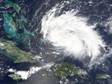
ATL : EX TOMAS - Discussion

Moderator: S2k Moderators

Message
Author
chrisjslucia
S2K Supporter
S2K Supporter
Posts: 236
Joined: Thu Oct 09, 2008 8:27 pm
Location: St Lucia

Re: ATL : TOMAS - Hurricane - Discussion

#741 Postby chrisjslucia » Sat Oct 30, 2010 1:58 pm

abajan wrote:
chrisjslucia wrote:Can anyone advise on likely changes in wind direction - from where next and when? Still coming at us from the North / North East and I'd guessed this would have changed by now.
It will shift to the SE within the next couple of hours, and when it does, I expect the wind to be really strong (especially in the south of the island by Hewanorra Airport)! So, be prepared.

The preceding response is NOT an official forecast and should not be used as such. It is just the opinion of the poster and may or may not be backed by sound meteorological data. It is NOT endorsed by any professional institution including storm2k.org. For Official Information please refer to the NHC and NWS products.

Thanks Abajan, I can see it now on the French radar, in fact we're currently getting a north wind plus gusts from the south east!
0 likes   

User avatar
expat2carib
S2K Supporter
S2K Supporter
Posts: 458
Joined: Tue Jul 22, 2008 1:44 pm
Location: Sint Maarten

Re: ATL : TOMAS - Hurricane - Discussion

#742 Postby expat2carib » Sat Oct 30, 2010 2:27 pm

Rain became torrential. Very chaotic wind pattern.
0 likes   

OURAGAN
Category 1
Category 1
Posts: 451
Joined: Sat Aug 07, 2004 12:18 pm
Location: GUADELOUPE

Re: ATL : TOMAS - Hurricane - Discussion

#743 Postby OURAGAN » Sat Oct 30, 2010 2:33 pm

I think Thomas is Stationnary E/NE of St Vincent since a few hours, i can see that on radar of Martinique it does not move at all
0 likes   

User avatar
cycloneye
Admin
Admin
Posts: 145347
Age: 68
Joined: Thu Oct 10, 2002 10:54 am
Location: San Juan, Puerto Rico

Re: ATL : TOMAS - Hurricane - Discussion

#744 Postby cycloneye » Sat Oct 30, 2010 2:38 pm

OURAGAN wrote:I think Thomas is Stationnary E/NE of St Vincent since a few hours, i can see that on radar of Martinique it does not move at all


Lets see in 3-6 hours,how it moves.But definitly it has slowed on the foward motion.
0 likes   
Visit the Caribbean-Central America Weather Thread where you can find at first post web cams,radars
and observations from Caribbean basin members Click Here

User avatar
Gustywind
Category 5
Category 5
Posts: 12334
Joined: Mon Sep 03, 2007 7:29 am
Location: Baie-Mahault, GUADELOUPE

Re: ATL : TOMAS - Hurricane - Discussion

#745 Postby Gustywind » Sat Oct 30, 2010 2:47 pm

expat2carib wrote:Rain became torrential. Very chaotic wind pattern.

:eek: hey be safe and dry :( !
0 likes   

snowcane180

#746 Postby snowcane180 » Sat Oct 30, 2010 3:07 pm

this system has really intensified since yesterday as a wave. I very well think this could easily become a cat 4
0 likes   

User avatar
Gustywind
Category 5
Category 5
Posts: 12334
Joined: Mon Sep 03, 2007 7:29 am
Location: Baie-Mahault, GUADELOUPE

#747 Postby Gustywind » Sat Oct 30, 2010 3:11 pm

Image
0 likes   

OURAGAN
Category 1
Category 1
Posts: 451
Joined: Sat Aug 07, 2004 12:18 pm
Location: GUADELOUPE

Re: ATL : TOMAS - Hurricane - Discussion

#748 Postby OURAGAN » Sat Oct 30, 2010 3:23 pm

it is moving now, north of ST VINCENT and south of St Lucia
0 likes   

User avatar
Aquawind
Category 5
Category 5
Posts: 6714
Age: 62
Joined: Mon Jun 16, 2003 10:41 pm
Location: Salisbury, NC
Contact:

Re: ATL : TOMAS - Hurricane - Discussion

#749 Postby Aquawind » Sat Oct 30, 2010 3:28 pm

Image
0 likes   

User avatar
expat2carib
S2K Supporter
S2K Supporter
Posts: 458
Joined: Tue Jul 22, 2008 1:44 pm
Location: Sint Maarten

Re: ATL : TOMAS - Hurricane - Discussion

#750 Postby expat2carib » Sat Oct 30, 2010 3:30 pm

OURAGAN wrote:it is moving now, north of ST VINCENT and south of St Lucia


Yes it is. I experienced the same feeling as you that it's been stationary for some hours.

The system didn't move on the Martinique radar. It's moving now on the radar.
0 likes   

User avatar
Gustywind
Category 5
Category 5
Posts: 12334
Joined: Mon Sep 03, 2007 7:29 am
Location: Baie-Mahault, GUADELOUPE

#751 Postby Gustywind » Sat Oct 30, 2010 3:31 pm

Tomas has difficulty to find its self with the relief of the St Vincent and St Lucia? :roll: ? :?:
0 likes   

Sanibel
Category 5
Category 5
Posts: 10375
Joined: Mon Aug 30, 2004 11:06 pm
Location: Offshore SW Florida

Re: ATL : TOMAS - Hurricane - Discussion

#752 Postby Sanibel » Sat Oct 30, 2010 3:39 pm

If Tomas hit the islands right at the edge of a transition from Atlantic airmass/synoptic to Caribbean it might temporarily hang-up.
0 likes   

User avatar
fci
S2K Supporter
S2K Supporter
Posts: 3324
Joined: Tue Sep 14, 2004 10:29 am
Location: Lake Worth, FL

#753 Postby fci » Sat Oct 30, 2010 3:43 pm

If he slows down and makes the turn earlier; maybe he crosses DR and Haiti can be spared the worst effects?
0 likes   

User avatar
Ivanhater
Storm2k Moderator
Storm2k Moderator
Posts: 11161
Age: 38
Joined: Fri Jul 01, 2005 8:25 am
Location: Pensacola

Re:

#754 Postby Ivanhater » Sat Oct 30, 2010 3:45 pm

fci wrote:If he slows down and makes the turn earlier; maybe he crosses DR and Haiti can be spared the worst effects?


The trough that might turn Tomas is not going to have any impact on the system for a while. A ridge is forecast to continue to build a top of Tomas for the next few days. That will move Tomas westward for a while.
0 likes   
Michael

User avatar
cycloneye
Admin
Admin
Posts: 145347
Age: 68
Joined: Thu Oct 10, 2002 10:54 am
Location: San Juan, Puerto Rico

Re: ATL : TOMAS - Hurricane - Discussion

#755 Postby cycloneye » Sat Oct 30, 2010 3:45 pm

Image
0 likes   
Visit the Caribbean-Central America Weather Thread where you can find at first post web cams,radars
and observations from Caribbean basin members Click Here

User avatar
cycloneye
Admin
Admin
Posts: 145347
Age: 68
Joined: Thu Oct 10, 2002 10:54 am
Location: San Juan, Puerto Rico

Re: ATL : TOMAS - Hurricane - Discussion

#756 Postby cycloneye » Sat Oct 30, 2010 3:52 pm

Important excerpt of 5 PM discussion.

HOWEVER...A BROAD LONGWAVE TROUGH CURRENTLY
ALONG THE U.S. WEST COAST IS EXPECTED TO MOVE EASTWARD AND THEN
SOUTHEASTWARD INTO THE SOUTHEASTERN UNITED STATES...AND PINCH OFF A
CLOSED LOW OVER THE GULF OF MEXICO AND SOUTHEASTERN MEXICO BY 120
HOURS. THE STRONG SOUTHWESTERLY FLOW ON THE EAST SIDE OF THE
AFOREMENTIONED TROUGH AND LOW IS EXPECTED TO RESULT IN A
SIGNIFICANT EROSION OF THE WESTERN PORTION OF THE GREATER ANTILLES
RIDGE AND CAUSE THE STEERING CURRENTS ACROSS THE WESTERN AND
CENTRAL CARIBBEAN SEA TO WEAKEN...ALLOWING TOMAS TO SLOW DOWN
CONSIDERABLY AND BEGIN TO MOVE POLEWARD. MOST OF THE MODEL GUIDANCE
IS IN GOOD AGREEMENT ON THIS GENERAL TRACK SCENARIO EXCEPT FOR
SPEED DIFFERENCES. THE OFFICIAL FORECAST TRACK IS JUST AN UPDATE OF
THE PREVIOUS ADVISORY TRACK...AND REMAINS ALONG THE SOUTHERN EDGE
OF THE NHC GUIDANCE ENVELOPE...BUT NOT AS FAR SOUTH AS THE GFS AND
ECMWF MODELS.

0 likes   
Visit the Caribbean-Central America Weather Thread where you can find at first post web cams,radars
and observations from Caribbean basin members Click Here

User avatar
TheDreamTraveler
Category 2
Category 2
Posts: 641
Joined: Sun Aug 22, 2010 3:10 am
Location: PA

Re: ATL : TOMAS - Hurricane - Discussion

#757 Postby TheDreamTraveler » Sat Oct 30, 2010 3:52 pm

cycloneye wrote:Image


Seems the turn towards Haiti is becoming more pronounced. It's still ironic how they missed all the other storms in the Atlantic, yet this will probably be one of the last storms of the season. And possibly one of the strongest.
0 likes   

snowcane180

#758 Postby snowcane180 » Sat Oct 30, 2010 3:56 pm

why is most of haiti deforested? any reasons?
0 likes   

User avatar
KWT
Category 5
Category 5
Posts: 31415
Joined: Tue Aug 17, 2004 11:02 am
Location: UK!!!

#759 Postby KWT » Sat Oct 30, 2010 3:57 pm

I bet this one goes east of the NHC forecast, but for now we will have to wait and see, probably going to have a solid 5-7 days in the Caribbean though and thats probably enough for this to become quite the hurricane IMO...

Presentation looks great on that radar, and outflow is just insane as well...
0 likes   
Personal Forecast Disclaimer:
The posts in this forum are NOT official forecast and should not be used as such. They are just the opinion of the poster and may or may not be backed by sound meteorological data. They are NOT endorsed by any professional institution or storm2k.org. For official information, please refer to the NHC and NWS products

User avatar
HurricaneStriker
Tropical Storm
Tropical Storm
Posts: 195
Joined: Fri Jun 25, 2010 7:23 pm
Location: Austin, TX

#760 Postby HurricaneStriker » Sat Oct 30, 2010 4:02 pm

I think Tomas will be the hurricane that gets 2010 to the hyperactive point in Accumulated Cyclone Energy - 153.

The posts in this forum are NOT official forecast and should not be used as such. They are just the opinion of the poster and may or may not be backed by sound meteorological data. They are NOT endorsed by any professional institution or storm2k.org. For official information, please refer to the NHC and NWS products.
0 likes   
217 Miles from the Texas Shore


Return to “2010”

Who is online

Users browsing this forum: No registered users and 3 guests