WPAC: MEGI (1013/15W) - Tropical Depression
Moderator: S2k Moderators
-
srainhoutx

- S2K Supporter

- Posts: 6919
- Age: 68
- Joined: Sun Jan 14, 2007 11:34 am
- Location: Haywood County, NC
- Contact:
Re: WPAC: MEGI - Typhoon
Stay safe folks. Very impressive cyclone...
0 likes
Carla/Alicia/Jerry(In The Eye)/Michelle/Charley/Ivan/Dennis/Katrina/Rita/Wilma/Ike/Harvey
Member: National Weather Association
Wx Infinity Forums
http://wxinfinity.com/index.php
Facebook.com/WeatherInfinity
Twitter @WeatherInfinity
Member: National Weather Association
Wx Infinity Forums
http://wxinfinity.com/index.php
Facebook.com/WeatherInfinity
Twitter @WeatherInfinity


Amazing system, its going to be a horrible 24hrs coming up for Luzon, the only thing is the land will probably tear Megi apart and it'll probably prevent Megi from beocming quite as strong again so a short lived peak...but gosh what a time for it to go mental and explode.
0 likes
Personal Forecast Disclaimer:
The posts in this forum are NOT official forecast and should not be used as such. They are just the opinion of the poster and may or may not be backed by sound meteorological data. They are NOT endorsed by any professional institution or storm2k.org. For official information, please refer to the NHC and NWS products
The posts in this forum are NOT official forecast and should not be used as such. They are just the opinion of the poster and may or may not be backed by sound meteorological data. They are NOT endorsed by any professional institution or storm2k.org. For official information, please refer to the NHC and NWS products
-
cycloneye

- Admin

- Posts: 149727
- Age: 69
- Joined: Thu Oct 10, 2002 10:54 am
- Location: San Juan, Puerto Rico
Re: WPAC: MEGI - Typhoon
keysha_gurl wrote:Hi experts!
Need your expertise! Is typhoon megi hitting hong kong? And if so, when? I don't want my trip there this wednesday to be cancelled
I hope everyone is keeping safe! God bless the Philippines at times like these!
Who wants to answer the question from this person that will travel to Hong Kong next Wednesday?
0 likes
Visit the Caribbean-Central America Weather Thread where you can find at first post web cams,radars
and observations from Caribbean basin members Click Here
and observations from Caribbean basin members Click Here


Re: WPAC: MEGI - Typhoon
Very healthy core.
No boundary layer inversions.
Great enhanced poleward outflow channel driven by TUTT directly east at 18N 147W.

No boundary layer inversions.
Great enhanced poleward outflow channel driven by TUTT directly east at 18N 147W.
0 likes


Yeah thats really obvious GCANE, its pretty impressive it has to be said.
I can't wait for the first Vis imagery in the morning over there, hopefully it still looks nearly as perfect as it does now...though I'm sure people in the way hope it falls apart in a big way.
Could you even imagine a gust of 190kts by the way!
I can't wait for the first Vis imagery in the morning over there, hopefully it still looks nearly as perfect as it does now...though I'm sure people in the way hope it falls apart in a big way.
Could you even imagine a gust of 190kts by the way!
0 likes
Personal Forecast Disclaimer:
The posts in this forum are NOT official forecast and should not be used as such. They are just the opinion of the poster and may or may not be backed by sound meteorological data. They are NOT endorsed by any professional institution or storm2k.org. For official information, please refer to the NHC and NWS products
The posts in this forum are NOT official forecast and should not be used as such. They are just the opinion of the poster and may or may not be backed by sound meteorological data. They are NOT endorsed by any professional institution or storm2k.org. For official information, please refer to the NHC and NWS products
-
oaba09
- S2K Supporter
- Posts: 1496
- Age: 39
- Joined: Thu Oct 01, 2009 10:02 am
- Location: Valenzuela, Philippines
- Contact:
FROM PAGASA(METRO MANILA PLACED UNDER SIGNAL NUMBER 1)

Typhoon "JUAN" has continued to intensify and increased its threat to Northern Luzon.
Location of Center:
(as of 4:00 p.m.) 390 km East of Aparri, Cagayan
Coordinates: 18.5°N, 125.7°E
Strength: Maximum winds of 225 kph near the center and
gustiness of up to 260 kph
Movement: West at 22 kph
Forecast Positions/Outlook: Monday afternoon:
100 km West Southwest of Aparri, Cagayan or
50 km Southeast of Laoag City
Tuesday afternoon:
500 km West of Laoag City
Areas Having Public Storm Warning Signal
PSWS # Luzon Visayas Mindanao
Signal No. 4
( >185 kph winds)
Cagayan
Isabela
Signal No.3
(100-185 kph winds)
Batanes
Calayan
Babuyan Group of Islands
Apayao
Kalinga
Mt. Province
Ifugao
Quirino
Nueva Vizcaya
Northern Aurora
Signal No. 2
(60-100 kph winds)
Ilocos Norte
Ilocos Sur
Abra
La Union
Benguet
Rest of Aurora
Signal No. 1
(30-60 kph winds)
Pangasinan
Tarlac
Nueva Ecija
Polillio Island
Cavite
Bulacan
Pampanga
Bataan
Zambales
Northern Quezon
Metro Manila
Rizal
0 likes

Re: WPAC: MEGI - Typhoon
Are the max sustained winds now at 155kts?
Just answered my question in the above thread:
MAX SUSTAINED WINDS - 155 KT, GUSTS 190 KT
Amazing!
Just answered my question in the above thread:
MAX SUSTAINED WINDS - 155 KT, GUSTS 190 KT
Amazing!
0 likes
The following post is NOT an official forecast and should not be used as such. It is just the opinion of the poster and may or may not be backed by sound meteorological data. It is NOT endorsed by any professional institution including storm2k.org For Official Information please refer to the NHC and NWS products.
-
srainhoutx
- S2K Supporter
- Posts: 6919
- Age: 68
- Joined: Sun Jan 14, 2007 11:34 am
- Location: Haywood County, NC
- Contact:
Re: WPAC: MEGI - Typhoon
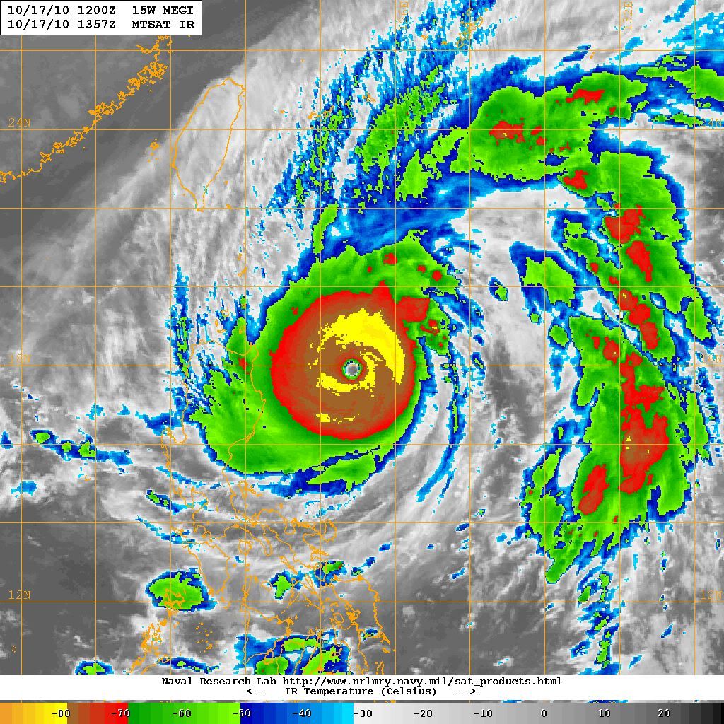
17/1430 UTC 17.9N 124.6E T7.5/7.5 MEGI
0 likes
Carla/Alicia/Jerry(In The Eye)/Michelle/Charley/Ivan/Dennis/Katrina/Rita/Wilma/Ike/Harvey
Member: National Weather Association
Wx Infinity Forums
http://wxinfinity.com/index.php
Facebook.com/WeatherInfinity
Twitter @WeatherInfinity
Member: National Weather Association
Wx Infinity Forums
http://wxinfinity.com/index.php
Facebook.com/WeatherInfinity
Twitter @WeatherInfinity
WTJP31 RJTD 171500
WARNING 171500.
WARNING VALID 181500.
TYPHOON WARNING.
TYPHOON 1013 MEGI (1013) 895 HPA
AT 17.9N 124.6E SEA EAST OF PHILIPPINES MOVING WESTSOUTHWEST 10
KNOTS.
POSITION GOOD.
MAX WINDS 120 KNOTS NEAR CENTER.
RADIUS OF OVER 50 KNOT WINDS 110 MILES.
RADIUS OF OVER 30 KNOT WINDS 325 MILES EAST SEMICIRCLE AND 220 MILES
ELSEWHERE.
FORECAST POSITION FOR 180300UTC AT 17.7N 122.6E WITH 50 MILES RADIUS
OF 70 PERCENT PROBABILITY CIRCLE.
900 HPA, MAX WINDS 115 KNOTS NEAR CENTER.
FORECAST POSITION FOR 181500UTC AT 17.5N 120.5E WITH 70 MILES RADIUS
OF 70 PERCENT PROBABILITY CIRCLE.
940 HPA, MAX WINDS 85 KNOTS NEAR CENTER.
JAPAN METEOROLOGICAL AGENCY.=
JMA has landfall shortly after 0300 UTC (11 am). 11 am forecast point is just off land NE of Ilagan.
0 likes


Re:
RL3AO wrote:IMO, this shows that JMA has a habit of underestimating storms. Strongest storm since 1991 best track wise, however, it took recon for them to go this low. I'd wager if there wasn't recon JMA would have this as a 110kt/915mb storm.
120 kt is pretty much the top end of their scale (JMA Dvorak T8.0 is 122 knots). They've only ever gone higher twice in history.
That said, if they didn't have recon, with their T7.5 fix they'd still have this down at 115 kt, and likely with that a 905 or 910 hPa pressure.
Last edited by Chacor on Sun Oct 17, 2010 11:22 am, edited 1 time in total.
0 likes
-
dwsqos2
Re: WPAC: MEGI - Typhoon
Yes, but this is the third case of a systems near the upper end of the JMA's Dvorak scale with winds far greater than the scale suggests. I posted this yesterday, but I get the feeling that the JMA's Dvorak scale, for t numbers greater than or equal to 6.5, likely underestimates the intensity of storms in the WPAC even accounting for the ten-minute mean.
Three Cases:
Jangmi in 2008
Megi yesterday
Megi today
A study of three does not a science make, but still.
Three Cases:
Jangmi in 2008
Megi yesterday
Megi today
A study of three does not a science make, but still.
0 likes
-
phwxenthusiast
- Category 2

- Posts: 637
- Joined: Wed Mar 24, 2010 3:10 am
- Location: Holbrook, NY (Long Island)


The saving grace for Luzon is that the population density along the E coast is low. There is a mountain range between where landfall will occur and the greater population centers around Tuguegarao and Cabagan (http://www.alertnet.org/thefacts/imager ... c2e9_0.jpg). I expect fast weakening of the winds once landfall occurs, though damaging winds will still be likely near the track. Also, Megi is forecasted to move fairly quickly, unlike past typhoons which have sat on the island dumping tremendous amounts of rain. This is not to downplay Megi's potential for destruction to life and property, as it will still be bad, but this area has seen many many big typhoons.
0 likes
Who is online
Users browsing this forum: No registered users and 39 guests