ATL: Remnants of PAULA - Discussion
Moderator: S2k Moderators
-
caneman
Re: ATL: PAULA - Hurricane - Discussion
Starting to get a bit concerning. I don't care what anyone says but it sure seems as if NOGAPS at this point has the right solution.
0 likes
Re: ATL: PAULA - Hurricane - Discussion
And earlier this morning, we were wondering whether Paula was going to be downgraded to a TS or in the end up dissipating
Just goes to show the unpredictability of these storms
Just goes to show the unpredictability of these storms
0 likes
-
petit_bois

- Tropical Storm

- Posts: 227
- Joined: Tue Jun 22, 2010 12:04 pm
- Location: Petit Bois Island Mississippi
Re: ATL: PAULA - Hurricane - Discussion
caneman wrote:Starting to get a bit concerning. I don't care what anyone says but it sure seems as if NOGAPS at this point has the right solution.
NOGAPS has a 1008mb system.
0 likes
Resident of the Atlantic Basin's Major Hurricane Hit Capital!
Camille (200+winds), Frederic, Goerges, Katrina... and many many more.
Disclaimer: I'm likely the smartest guy here... but I have no idea where a tropical cyclone will go. I suggest you take my opinion as a grain of salt. I suggest you look to the National Hurricane Center for accurate info.
Camille (200+winds), Frederic, Goerges, Katrina... and many many more.
Disclaimer: I'm likely the smartest guy here... but I have no idea where a tropical cyclone will go. I suggest you take my opinion as a grain of salt. I suggest you look to the National Hurricane Center for accurate info.
Re: ATL: PAULA - Hurricane - Discussion
petit_bois wrote:caneman wrote:Starting to get a bit concerning. I don't care what anyone says but it sure seems as if NOGAPS at this point has the right solution.
NOGAPS has a 1008mb system.
Interesting....either it initialized it weak or the front just shears it apart coming towards Florida...however, I know that models are not good indicators for strength
0 likes
-
caneman
Re: ATL: PAULA - Hurricane - Discussion
petit_bois wrote:caneman wrote:Starting to get a bit concerning. I don't care what anyone says but it sure seems as if NOGAPS at this point has the right solution.
NOGAPS has a 1008mb system.
I'm talking direction and handle of atmosphere not intensity. Models aren't good with intensity but in the end it may get that right too. We'll see.
0 likes
-
SouthDadeFish

- Professional-Met

- Posts: 2836
- Joined: Thu Sep 23, 2010 2:54 pm
- Location: Miami, FL
- Contact:

Re: ATL: PAULA - Hurricane - Discussion
First off the normal 'stronger it is more poleward it goes' argument is rapidly rearing it's head...especially with the light winds recon had at altitude on the way in. Secondly several in here have remarked that the initial development was 'missed' by the NHC and may had been stronger earlier....which leads to where the heck is the global hawk or GIV? If any storm needs high altitude sniffing around to let the models get any handle on what is happening it is this one...intensifying in an area historically known for developing problems for the Continental US and within 500 miles of the Florida Peninsula and the Keys.
0 likes


-
FLpanhandle91

- Category 5

- Posts: 1039
- Age: 35
- Joined: Mon Sep 13, 2010 3:50 pm
- Location: Fort Walton Beach, FL
Re: ATL: PAULA - Hurricane - Discussion
Looks like this thing is about to get a bit stronger. The outflow from the anticyclone seems to be expanding in recent frames.
0 likes
-
Blown Away

- S2K Supporter

- Posts: 10253
- Joined: Wed May 26, 2004 6:17 am
Re: ATL: PAULA - Hurricane - Discussion
Doesn't look like the NHC is going with a stronger/deeper Paula will go more poleward and be steered by more SW flow. They bumped up her intensity but esentially kept the same track.
0 likes
Hurricane Eye Experience: David 79, Irene 99, Frances 04, Jeanne 04, Wilma 05… Hurricane Brush Experience: Andrew 92, Erin 95, Floyd 99, Matthew 16, Irma 17, Ian 22, Nicole 22…
-
Evil Jeremy

- S2K Supporter
- Posts: 5463
- Age: 32
- Joined: Mon Apr 10, 2006 2:10 pm
- Location: Los Angeles, CA
Re: ATL: PAULA - Hurricane - Discussion
Blown Away wrote:Doesn't look like the NHC is going with a stronger/deeper Paula will go more poleward and be steered by more SW flow. They bumped up her intensity but esentially kept the same track.
They don't change track on special advisories. Just like with intermediates.
Last edited by Evil Jeremy on Tue Oct 12, 2010 1:31 pm, edited 1 time in total.
0 likes
Frances 04 / Jeanne 04 / Katrina 05 / Wilma 05 / Fay 08 / Debby 12 / Andrea 13 / Colin 16 / Hermine 16 / Matthew 16 / Irma 17
-
cycloneye

- Admin

- Posts: 149725
- Age: 69
- Joined: Thu Oct 10, 2002 10:54 am
- Location: San Juan, Puerto Rico
Re: ATL: PAULA - Hurricane - Discussion
Blown Away wrote:Doesn't look like the NHC is going with a stronger/deeper Paula will go more poleward and be steered by more SW flow. They bumped up her intensity but esentially kept the same track.
In Special Advisories,the track doesn't change.
0 likes
Visit the Caribbean-Central America Weather Thread where you can find at first post web cams,radars
and observations from Caribbean basin members Click Here
and observations from Caribbean basin members Click Here

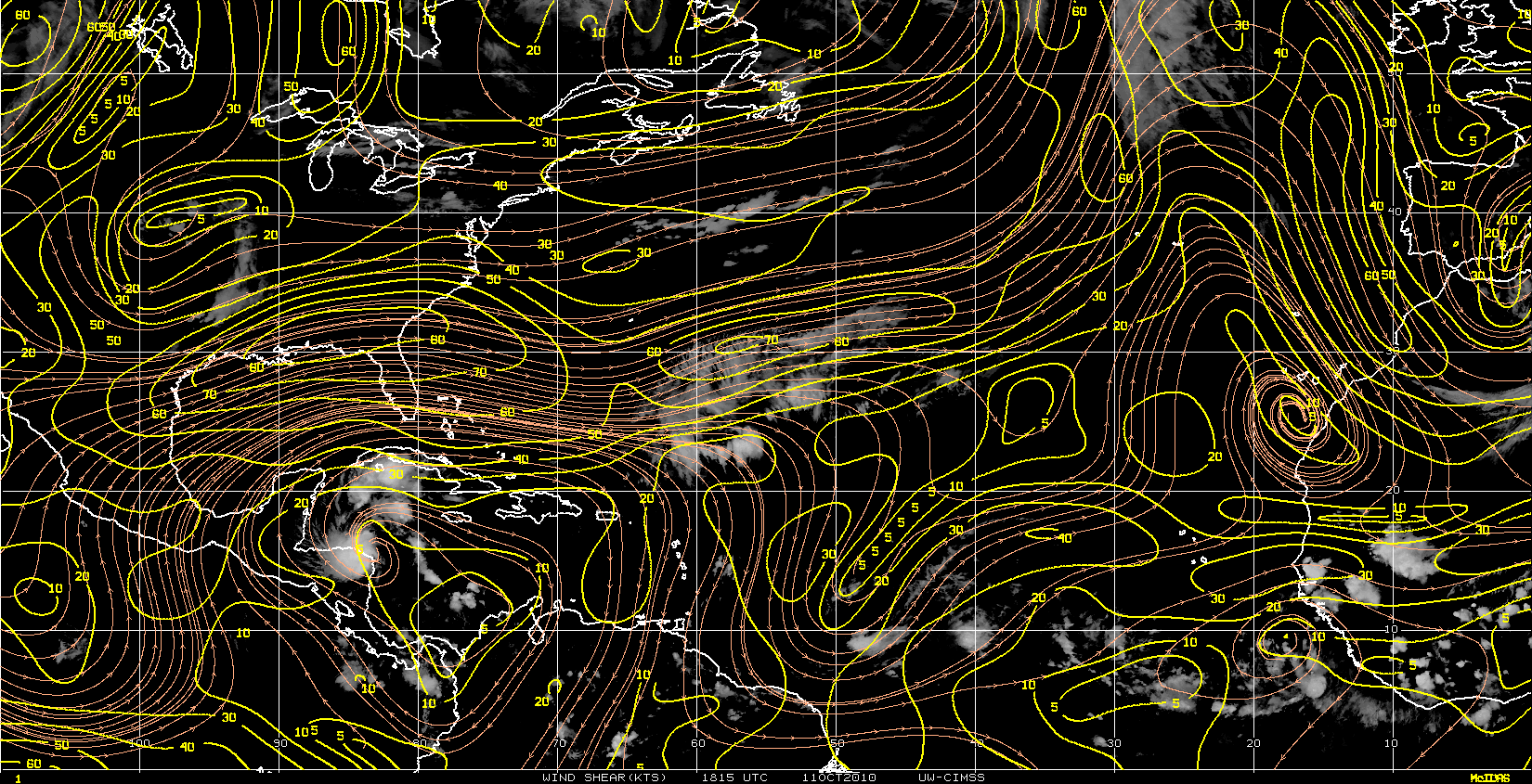
Re: ATL: PAULA - Hurricane - Discussion
Paula's small size could certainly allow rapid intensification, especially with cooler thunderstorm cloud tops in the eyewall.
0 likes
Let me add that of course the folks on the northeast end of the Yucatan Peninsula and the western tip of Cuba are now getting a heck of a wake up call with this 'stronger than forecast by the NHC' Cat2 upgrade....and it is on their doorstep.
In fact the Cancun radar appears to now have the eye on the last frame at 1815z...the location matches with sat pix.
In fact the Cancun radar appears to now have the eye on the last frame at 1815z...the location matches with sat pix.
Last edited by hiflyer on Tue Oct 12, 2010 1:48 pm, edited 1 time in total.
0 likes

Re: ATL: PAULA - Hurricane - Discussion
Paula is becoming the dominant convection in the west Carib and SE GOM area.
That should allow the tropopause to build a dome centered over Paula due to diabatic heating of the upper troposphere.
The effect should be seen as a movement of the anti-cyclone to over the LLC.
This in turn should show up as a reduction in shear around Paula.


That should allow the tropopause to build a dome centered over Paula due to diabatic heating of the upper troposphere.
The effect should be seen as a movement of the anti-cyclone to over the LLC.
This in turn should show up as a reduction in shear around Paula.
0 likes
-
northjaxpro

- S2K Supporter
- Posts: 8900
- Joined: Mon Sep 27, 2010 11:21 am
- Location: Jacksonville, FL
Re: ATL: PAULA - Hurricane - Discussion
caneseddy wrote:And earlier this morning, we were wondering whether Paula was going to be downgraded to a TS or in the end up dissipating
Just goes to show the unpredictability of these storms
You are exactly right. Just about 6 hours ago, it appeared on imagery that Paula was undergoing some weakening with the inner core as it appeared dry air was being ingested into her at that time.
What a difference six hours make. Paula's small, but well comapcted and defined inner core really has taken shape since this morning and Recon has now found a rapidly intensifying tropical cyclone. Amazing indeed. These small compact cyclones can intensify and weaken rapidly.
Paula looks likely poised to become another major hurricane in this season. A fascinating system to monitor.
Last edited by northjaxpro on Tue Oct 12, 2010 1:43 pm, edited 1 time in total.
0 likes
NEVER, EVER SAY NEVER in the tropics and weather in general, and most importantly, with life itself!!
________________________________________________________________________________________
Fay 2008 Beryl 2012 Debby 2012 Colin 2016 Hermine 2016 Julia 2016 Matthew 2016 Irma 2017 Dorian 2019
________________________________________________________________________________________
Fay 2008 Beryl 2012 Debby 2012 Colin 2016 Hermine 2016 Julia 2016 Matthew 2016 Irma 2017 Dorian 2019

Re: ATL: PAULA - Hurricane - Discussion
Blown Away wrote:Doesn't look like the NHC is going with a stronger/deeper Paula will go more poleward and be steered by more SW flow. They bumped up her intensity but esentially kept the same track.
I think that the bottom line remains that from a Florida perspective; nothing changes based on the intensity of Paula.
No one sees this as a threat to Florida A's anything more than a sheared TS and most likely she will never get here at all. Concerns for Cancun, Cozumel and Cuba notwithstanding.
0 likes
-
AdamFirst

- S2K Supporter
- Posts: 2490
- Age: 36
- Joined: Thu Aug 14, 2008 10:54 am
- Location: Port Saint Lucie, FL
Just for size comparison, how big was Andrew? Andrew was a small storm as well.
0 likes
Dolphins Marlins Canes Golden Panthers HEAT
Andrew 1992 - Irene 1999 - Frances 2004 - Jeanne 2004 - Wilma 2005 - Fay 2008 - Isaac 2012 - Matthew 2016 - Irma 2017 - Dorian 2019 - Ian 2022 - Nicole 2022 - Milton 2024
Andrew 1992 - Irene 1999 - Frances 2004 - Jeanne 2004 - Wilma 2005 - Fay 2008 - Isaac 2012 - Matthew 2016 - Irma 2017 - Dorian 2019 - Ian 2022 - Nicole 2022 - Milton 2024
Re:
hiflyer wrote:Let me add that of course the folks on the northeast end of the Yucatan Peninsula and the western tip of Cuba are now getting a heck of a wake up call with this 'stronger than forecast by the NHC' Cat2 upgrade....and it is on their doorstep.
Reports I saw last night indicated that Cat 2 WAS forecasted.
0 likes
-
AdamFirst
- S2K Supporter
- Posts: 2490
- Age: 36
- Joined: Thu Aug 14, 2008 10:54 am
- Location: Port Saint Lucie, FL
Re: Re:
fci wrote:Reports I saw last night indicated that Cat 2 WAS forecasted.
Not this quickly, however.
0 likes
Dolphins Marlins Canes Golden Panthers HEAT
Andrew 1992 - Irene 1999 - Frances 2004 - Jeanne 2004 - Wilma 2005 - Fay 2008 - Isaac 2012 - Matthew 2016 - Irma 2017 - Dorian 2019 - Ian 2022 - Nicole 2022 - Milton 2024
Andrew 1992 - Irene 1999 - Frances 2004 - Jeanne 2004 - Wilma 2005 - Fay 2008 - Isaac 2012 - Matthew 2016 - Irma 2017 - Dorian 2019 - Ian 2022 - Nicole 2022 - Milton 2024
Who is online
Users browsing this forum: No registered users and 59 guests