ATL: Remnants of PAULA - Discussion
Moderator: S2k Moderators
-
AdamFirst

- S2K Supporter

- Posts: 2490
- Age: 36
- Joined: Thu Aug 14, 2008 10:54 am
- Location: Port Saint Lucie, FL
Re: ATL: PAULA - Hurricane - Discussion
Would the storm survive the loop? Could we see the dreaded naked swirl from paula after it's done?
0 likes
Dolphins Marlins Canes Golden Panthers HEAT
Andrew 1992 - Irene 1999 - Frances 2004 - Jeanne 2004 - Wilma 2005 - Fay 2008 - Isaac 2012 - Matthew 2016 - Irma 2017 - Dorian 2019 - Ian 2022 - Nicole 2022 - Milton 2024
Andrew 1992 - Irene 1999 - Frances 2004 - Jeanne 2004 - Wilma 2005 - Fay 2008 - Isaac 2012 - Matthew 2016 - Irma 2017 - Dorian 2019 - Ian 2022 - Nicole 2022 - Milton 2024

Its tough to call AF, it'd probably struggle and the models suggest it would weak, but then again they've done a turgid job with this one thus far in terms of strength, only GFDL has come close thus far...
Hopefully this doesn't turn into a Fay where it can't quite make its mind as to where to go...
Hopefully this doesn't turn into a Fay where it can't quite make its mind as to where to go...
0 likes
Personal Forecast Disclaimer:
The posts in this forum are NOT official forecast and should not be used as such. They are just the opinion of the poster and may or may not be backed by sound meteorological data. They are NOT endorsed by any professional institution or storm2k.org. For official information, please refer to the NHC and NWS products
The posts in this forum are NOT official forecast and should not be used as such. They are just the opinion of the poster and may or may not be backed by sound meteorological data. They are NOT endorsed by any professional institution or storm2k.org. For official information, please refer to the NHC and NWS products

Re: ATL: PAULA - Hurricane - Discussion
Paula seems to still be feeling the effects of being close to land.
As land surface temps cool at night, boundary-layer air becomes stable.
This in turn works its way into the core and causes convection to weaken.
Rain-rate now is light.
However, core is warm at 1C and relatively narrow.
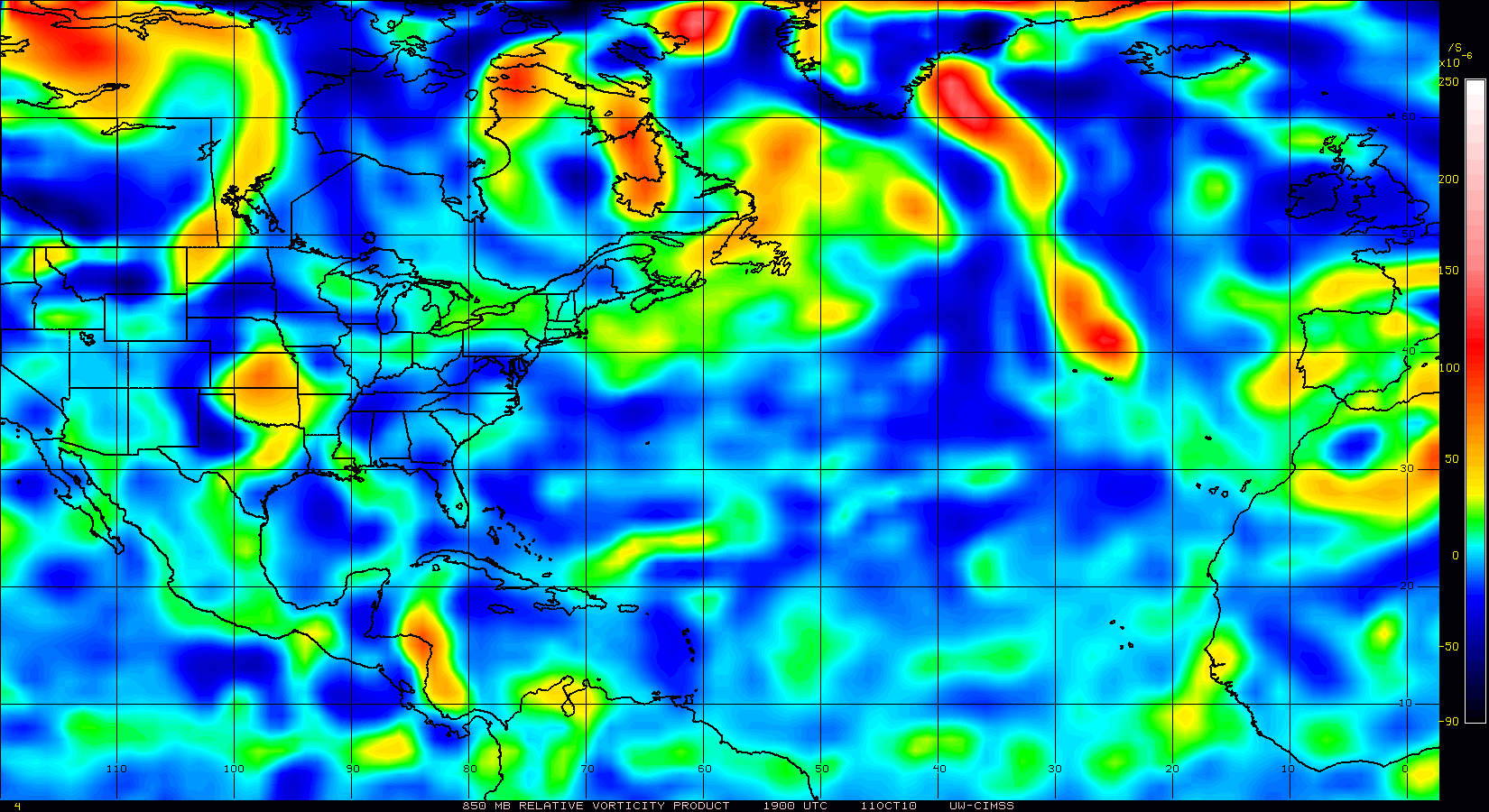
850mb vorticity is somewhat elongated, but much improved since yesterday at this time.
I think we will see the same scenario today as yesterday.
When the sun starts heating the land surface, air will destabilize and that in turn will help to ramp up Paula.


As land surface temps cool at night, boundary-layer air becomes stable.
This in turn works its way into the core and causes convection to weaken.
Rain-rate now is light.
However, core is warm at 1C and relatively narrow.
850mb vorticity is somewhat elongated, but much improved since yesterday at this time.
I think we will see the same scenario today as yesterday.
When the sun starts heating the land surface, air will destabilize and that in turn will help to ramp up Paula.
0 likes

-
cyclonic chronic
Nimbus, at the moment I'd take any track the NHC comes up with a huge pinch of salt because the models are everywhere...
I personally don't buy the large lazy loop the NHC are suggesting, given its current forward speed and the way its got elongated to the north I think its going to either stall near the YUcatan channel and get slowly sheared apart whilst moving towards S.Florida like the GFDL or drift ENE towards Cuba/Keys from that position but the starting point is to the north of the NHC.
If the NHC current forecast is correct then Paula probably will get slowly sheared apart but as long as it keeps some eastward component to the motion once its north of 23N then it probably will be slow to weaken.
0 likes
Personal Forecast Disclaimer:
The posts in this forum are NOT official forecast and should not be used as such. They are just the opinion of the poster and may or may not be backed by sound meteorological data. They are NOT endorsed by any professional institution or storm2k.org. For official information, please refer to the NHC and NWS products
The posts in this forum are NOT official forecast and should not be used as such. They are just the opinion of the poster and may or may not be backed by sound meteorological data. They are NOT endorsed by any professional institution or storm2k.org. For official information, please refer to the NHC and NWS products
-
AdamFirst
- S2K Supporter
- Posts: 2490
- Age: 36
- Joined: Thu Aug 14, 2008 10:54 am
- Location: Port Saint Lucie, FL
Re:
Nimbus wrote:The NHC has Paula as only a tropical storm meandering south of Cuba by the end of the week. Dry shear off the Yucatan shoulld hopefully weaken her before she gets near Cuba or south Florida. Paula would need to continue expanding her moisture envelope north if she is to be a US threat.
That disturbance that's currently over the florida straits and central cuba...you think that would carve a significant hole in that dry air?
0 likes
Dolphins Marlins Canes Golden Panthers HEAT
Andrew 1992 - Irene 1999 - Frances 2004 - Jeanne 2004 - Wilma 2005 - Fay 2008 - Isaac 2012 - Matthew 2016 - Irma 2017 - Dorian 2019 - Ian 2022 - Nicole 2022 - Milton 2024
Andrew 1992 - Irene 1999 - Frances 2004 - Jeanne 2004 - Wilma 2005 - Fay 2008 - Isaac 2012 - Matthew 2016 - Irma 2017 - Dorian 2019 - Ian 2022 - Nicole 2022 - Milton 2024
Re:
cyclonic chronic wrote:great synopsis GCANE. never thought about dry air comming from land once the land surface cools at night. are there any papers/studies that've been done on this?
It does make alot of sense doesn't it, with the lapse rates decreasing overnight overland and the systems inflow coming from overland the system probably would be taking in more stable air overnight, and that'd probably simply balance out any gains the system would get from Dmax and the increase of lapse rates overwater.
0 likes
Personal Forecast Disclaimer:
The posts in this forum are NOT official forecast and should not be used as such. They are just the opinion of the poster and may or may not be backed by sound meteorological data. They are NOT endorsed by any professional institution or storm2k.org. For official information, please refer to the NHC and NWS products
The posts in this forum are NOT official forecast and should not be used as such. They are just the opinion of the poster and may or may not be backed by sound meteorological data. They are NOT endorsed by any professional institution or storm2k.org. For official information, please refer to the NHC and NWS products
Re:
cyclonic chronic wrote:great synopsis GCANE. never thought about dry air comming from land once the land surface cools at night. are there any papers/studies that've been done on this?
Thanks CC. Let me see what I can find and I'll post them later.
I just did a HYSPLIT trajectory for two parcels.
One to the east of the LLC at 17N 80W and another west at 17N 90W.
The area to the east seems to have a very unstable Lifted Index.
I am seeing values of around -7.
http://www.ssd.noaa.gov/goes/flt/t2/loop-wv.html
It could be due to the strong MCS firing to the NE of Paula and feeding moisture into that area.
From the trajectory analysis, it looks like there is strong ascent into Paula.
On the west of Paula, ascent is limited.
I have also included some soundings below for areas close by these as well.


0 likes
It'd make sense ascent is limited to the west given there is the Yucatan landmass to the west and as your map shows it doesn't look at all impressive on the western side, though the eastern side looks pretty neat at the moment in that respect.
Given wats happened overnight we'll probably see it hold steady today with maybe only a slight shift in strength maybe briefly down to TS unless the core strengthens in the next 3-6hrs.
Given wats happened overnight we'll probably see it hold steady today with maybe only a slight shift in strength maybe briefly down to TS unless the core strengthens in the next 3-6hrs.
0 likes
Personal Forecast Disclaimer:
The posts in this forum are NOT official forecast and should not be used as such. They are just the opinion of the poster and may or may not be backed by sound meteorological data. They are NOT endorsed by any professional institution or storm2k.org. For official information, please refer to the NHC and NWS products
The posts in this forum are NOT official forecast and should not be used as such. They are just the opinion of the poster and may or may not be backed by sound meteorological data. They are NOT endorsed by any professional institution or storm2k.org. For official information, please refer to the NHC and NWS products
Re:
KWT wrote:It'd make sense ascent is limited to the west given there is the Yucatan landmass to the west and as your map shows it doesn't look at all impressive on the western side, though the eastern side looks pretty neat at the moment in that respect.
Given wats happened overnight we'll probably see it hold steady today with maybe only a slight shift in strength maybe briefly down to TS unless the core strengthens in the next 3-6hrs.
The current inversion in the bounday layer doesn't look that strong. CINH is 0 on the Puerto Barrios Sounding.
So, if cloud cover is not too bad, solar heating of the landmass could destabilze the air later today and the west infeed could improve.
0 likes
-
HURRICANELONNY
- Category 5

- Posts: 1392
- Joined: Wed May 07, 2003 6:48 am
- Location: HOLLYWOOD.FL
Re: ATL: PAULA - Hurricane - Discussion
http://www.ssd.noaa.gov/goes/flt/t2/flash-jsl.html
Looks like Paula is moving more NNW. Makes sense since the High is moving out. I think Paula will do what Paula wants.
Looks like Paula is moving more NNW. Makes sense since the High is moving out. I think Paula will do what Paula wants.
0 likes
hurricanelonny
-
SouthFloridawx

- S2K Supporter
- Posts: 8346
- Age: 47
- Joined: Tue Jul 26, 2005 1:16 am
- Location: Sarasota, FL
- Contact:
Re: ATL: PAULA - Hurricane - Discussion
Looks like the shear is decreasing ahead of Paula to the north. That will give her a little more time if the trend continues. If she continues to deepen, she could move more poleward.
http://cimss.ssec.wisc.edu/tropic2/real-time/windmain.php?&basin=atlantic&sat=wg8&prod=sht&zoom=&time=
http://cimss.ssec.wisc.edu/tropic2/real-time/windmain.php?&basin=atlantic&sat=wg8&prod=sht&zoom=&time=
0 likes

Re: ATL: PAULA - Hurricane - Discussion
The tone of excitement that was here last night is significantly lower this a.m. I'm sticking with the fat lady. 
0 likes
-
wzrgirl1

- S2K Supporter
- Posts: 1360
- Joined: Sat Sep 04, 2004 6:44 am
- Location: Pembroke Pines, Florida
Re: ATL: PAULA - Hurricane - Discussion
Please remember that a stronger storm will go more poleward....so the intensity of Paula is really the key here. By the end of the day we shall have a better feel for where she is headed. Just a 1 degree movement north can make all the difference in the world. 
0 likes
-
wxman57

- Moderator-Pro Met

- Posts: 23175
- Age: 68
- Joined: Sat Jun 21, 2003 8:06 pm
- Location: Houston, TX (southwest)
Re: ATL: PAULA - Hurricane - Discussion
The farther north Paula goes, the higher the shear. Take a look at the projected upper-level wind flow across FL and the FL Straits in 3 days. Westerly winds 50-60 kts over south FL, 100 kts over the northern Peninsula in the jet core. It will be hard to get a hurricane to hit Florida with that wind flow. And the upper winds don't really diminish over the next week or two.
Paula could well be picked up by the trof and accelerated to the NE as per the GFDL, or it could be weakened significantly by increasing shear, perhaps dissipating in the NW Caribbean. I'm starting to favor the former.

Paula could well be picked up by the trof and accelerated to the NE as per the GFDL, or it could be weakened significantly by increasing shear, perhaps dissipating in the NW Caribbean. I'm starting to favor the former.
0 likes
-
chrisjslucia
- S2K Supporter
- Posts: 236
- Joined: Thu Oct 09, 2008 8:27 pm
- Location: St Lucia
Re: ATL: PAULA - Hurricane - Discussion
I'm having real trouble balancing out the five day cone with the range of model tracks. The cone is showing a track to the East followed by a South East direction - heading back across the Caribbean from whence it came!. The models are showing a range of possibilities but none that I see are matching the cone. Can anyone explain and also advise / comment on the potential for a reverse route south east?
Thanks!
Thanks!
0 likes

Re: ATL: PAULA - Hurricane - Discussion
Besides Paula abd her track I'm trying to figure out where Richard forms and from what?
0 likes
Re: ATL: PAULA - Hurricane - Discussion
NHC knew its stuff on intensity this time. The dominating weather features trumping threatening storms is once again the prevailing theme of 2010. No great 1924 storm from this one. The massive dry air front dominating the GOM had the last word. In hindsight the convection bank going off to the NE should have been a clue this wasn't organized strongly.
Last edited by Sanibel on Tue Oct 12, 2010 7:51 am, edited 1 time in total.
0 likes
Who is online
Users browsing this forum: No registered users and 39 guests