ATL: Remnants of PAULA - Discussion

Moderator: S2k Moderators

Message
Author
Florida1118

Re: ATL : INVEST 98L - Discussion - Code Red 60%

#161 Postby Florida1118 » Sat Oct 09, 2010 6:51 pm

Zecadiabo wrote:any chance it could hit Yucatan?

Ask the monkey with a dart and map. :D We dont know what so ever.
0 likes   

User avatar
KWT
Category 5
Category 5
Posts: 31415
Joined: Tue Aug 17, 2004 11:02 am
Location: UK!!!

#162 Postby KWT » Sat Oct 09, 2010 6:55 pm

Certainly can't rule out it taking a trip towards Mexico if the trough turns out to be a little weaker then forecasted, right now its just to early to call, but alot of CA in general, Cuba, S.Florida/keys and the Bahamas all need to watch this, and obviously thats an awful lot of land that needs to be aware this system is out there simmering.
0 likes   
Personal Forecast Disclaimer:
The posts in this forum are NOT official forecast and should not be used as such. They are just the opinion of the poster and may or may not be backed by sound meteorological data. They are NOT endorsed by any professional institution or storm2k.org. For official information, please refer to the NHC and NWS products

User avatar
Vortex
S2K Supporter
S2K Supporter
Posts: 4644
Age: 53
Joined: Fri Aug 01, 2003 9:34 pm
Location: Hilton Head, SC

#163 Postby Vortex » Sat Oct 09, 2010 7:18 pm

Looking at climatology back to the mid 1800's between October 10th-20th 2 VERY IMPORTANT benchmarks come to mind..

If this system forms S of 15N and W of 80W climatology suggest it will continue NW and if it winds up near 20N and 85W 9X out of 10 these past storms impacted western cuba/sfl... something to ponder...
0 likes   

User avatar
HURAKAN
Professional-Met
Professional-Met
Posts: 46086
Age: 38
Joined: Thu May 20, 2004 4:34 pm
Location: Key West, FL
Contact:

#164 Postby HURAKAN » Sat Oct 09, 2010 7:23 pm

Image

nice burst
0 likes   

User avatar
GCANE
S2K Supporter
S2K Supporter
Posts: 11496
Joined: Mon Oct 22, 2007 8:03 am

Re: ATL : INVEST 98L - Discussion - Code Red 60%

#165 Postby GCANE » Sat Oct 09, 2010 7:25 pm

Wow, didn't take long for the hot-towers to get the anti-cyclone moved quickly to nearly over 98L.

That cell south of Jamaica is impressive.

Image

Image
0 likes   

User avatar
GCANE
S2K Supporter
S2K Supporter
Posts: 11496
Joined: Mon Oct 22, 2007 8:03 am

Re: ATL : INVEST 98L - Discussion - Code Red 60%

#166 Postby GCANE » Sat Oct 09, 2010 7:27 pm

0 likes   

User avatar
expat2carib
S2K Supporter
S2K Supporter
Posts: 458
Joined: Tue Jul 22, 2008 1:44 pm
Location: Sint Maarten

Re: ATL : INVEST 98L - Discussion - Code Red 60%

#167 Postby expat2carib » Sat Oct 09, 2010 7:35 pm

Almost looks like 2 different systems that are exploding simultaneously

Are the two cells part of the same system?
0 likes   

User avatar
dixiebreeze
S2K Supporter
S2K Supporter
Posts: 5140
Joined: Wed Sep 03, 2003 5:07 pm
Location: crystal river, fla.

Re: ATL : INVEST 98L - Discussion - Code Red 60%

#168 Postby dixiebreeze » Sat Oct 09, 2010 7:40 pm

09/2345 UTC 12.7N 81.0W T1.5/1.5 98L -- Atlantic
0 likes   

User avatar
SouthDadeFish
Professional-Met
Professional-Met
Posts: 2835
Joined: Thu Sep 23, 2010 2:54 pm
Location: Miami, FL
Contact:

#169 Postby SouthDadeFish » Sat Oct 09, 2010 7:42 pm

:uarrow: That's good enough for depression classification.
0 likes   

User avatar
HURAKAN
Professional-Met
Professional-Met
Posts: 46086
Age: 38
Joined: Thu May 20, 2004 4:34 pm
Location: Key West, FL
Contact:

#170 Postby HURAKAN » Sat Oct 09, 2010 7:48 pm

0 likes   

User avatar
GCANE
S2K Supporter
S2K Supporter
Posts: 11496
Joined: Mon Oct 22, 2007 8:03 am

Re: ATL : INVEST 98L - Discussion - Code Red 60%

#171 Postby GCANE » Sat Oct 09, 2010 7:51 pm

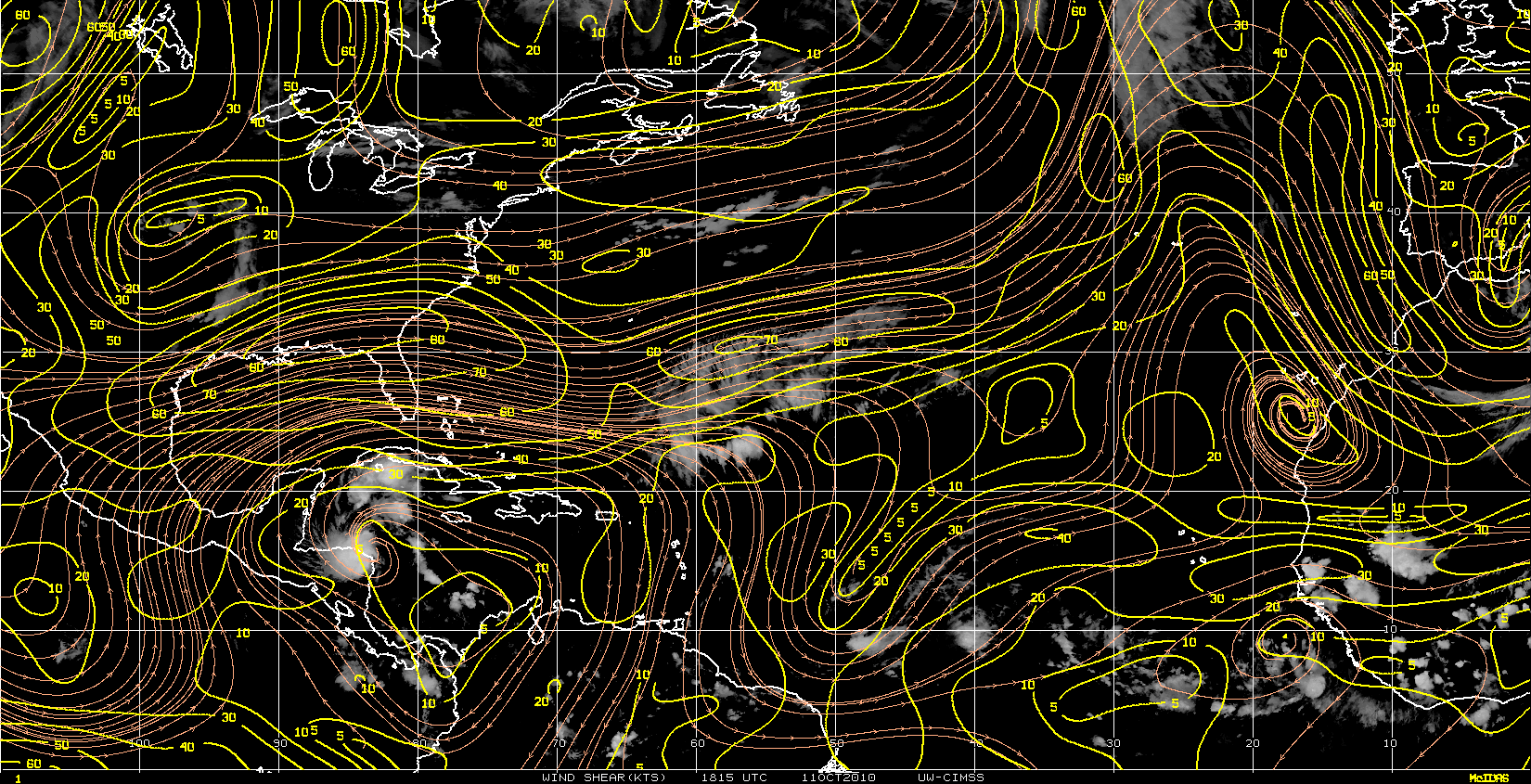
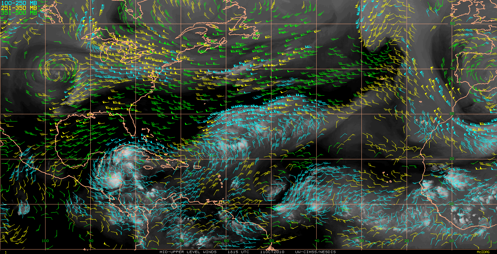
expat2carib wrote:Almost looks like 2 different systems that are exploding simultaneously

Are the two cells part of the same system?


The cell south of Jamaica is pretty far from the LLC.

Wind-field is starting to look like a TD.


Image
0 likes   

User avatar
Typhoon_Willie
Category 5
Category 5
Posts: 1042
Joined: Mon Jun 09, 2003 3:19 pm
Location: Greenacres City, Florida

Re: ATL : INVEST 98L - Discussion - Code Red 60%

#172 Postby Typhoon_Willie » Sat Oct 09, 2010 7:53 pm

With this water vapor loop it would seem that the moisture envelope with 98l is slowly moving northward. You can see it creeping up over central Cuba.
0 likes   

User avatar
SouthDadeFish
Professional-Met
Professional-Met
Posts: 2835
Joined: Thu Sep 23, 2010 2:54 pm
Location: Miami, FL
Contact:

#173 Postby SouthDadeFish » Sat Oct 09, 2010 7:53 pm

How is this not a TD?
0 likes   

CrazyC83
Professional-Met
Professional-Met
Posts: 34002
Joined: Tue Mar 07, 2006 11:57 pm
Location: Deep South, for the first time!

#174 Postby CrazyC83 » Sat Oct 09, 2010 7:55 pm

They can't delay for persistence since a Tropical Storm Warning would be needed for the Nicaragua coast.
0 likes   

User avatar
HURAKAN
Professional-Met
Professional-Met
Posts: 46086
Age: 38
Joined: Thu May 20, 2004 4:34 pm
Location: Key West, FL
Contact:

#175 Postby HURAKAN » Sat Oct 09, 2010 7:56 pm

00z

AL, 98, 2010101000, , BEST, 0, 135N, 812W, 25, 1007, LO
0 likes   

User avatar
expat2carib
S2K Supporter
S2K Supporter
Posts: 458
Joined: Tue Jul 22, 2008 1:44 pm
Location: Sint Maarten

Re: ATL : INVEST 98L - Discussion - Code Red 60%

#176 Postby expat2carib » Sat Oct 09, 2010 7:59 pm

A Coup d'état by the cell south of Jamaica. 8-)
Last edited by expat2carib on Sat Oct 09, 2010 8:01 pm, edited 1 time in total.
0 likes   

User avatar
GCANE
S2K Supporter
S2K Supporter
Posts: 11496
Joined: Mon Oct 22, 2007 8:03 am

Re: ATL : INVEST 98L - Discussion - Code Red 60%

#177 Postby GCANE » Sat Oct 09, 2010 8:01 pm

Nice outflow channels


Image
0 likes   

hurricaneCW
Category 5
Category 5
Posts: 1794
Joined: Wed Mar 03, 2010 6:20 am
Location: Toms River, NJ

Re: ATL : INVEST 98L - Discussion - Code Red 60%

#178 Postby hurricaneCW » Sat Oct 09, 2010 8:06 pm

That big burst was definitely enough to give it a Code Red, I said 50% because cloud tops were warming at the time. So it could be a TD a bit earlier than Monday if it continues to get better organized, but I still say we won't see a TD until Monday.
0 likes   

User avatar
FLpanhandle91
Category 5
Category 5
Posts: 1033
Age: 34
Joined: Mon Sep 13, 2010 3:50 pm
Location: Fort Walton Beach, FL

Re: ATL : INVEST 98L - Discussion - Code Red 60%

#179 Postby FLpanhandle91 » Sat Oct 09, 2010 8:15 pm

TD by 11 AM at the earliest. TS Paula within 24 hours.. What is steering this thing? High pressure to the east?
0 likes   

User avatar
Vortex
S2K Supporter
S2K Supporter
Posts: 4644
Age: 53
Joined: Fri Aug 01, 2003 9:34 pm
Location: Hilton Head, SC

#180 Postby Vortex » Sat Oct 09, 2010 8:16 pm

I think TD by 11am after first vis in the morning..Paula by 5pm...Bullish but so is the appearance this evening backed by surface observations..IMO, we've already not that far off from a TS...
0 likes   


Return to “2010”

Who is online

Users browsing this forum: No registered users and 3 guests