This is a boring system to be forced to keep an eye on.
To keep an eye on means in my situation to "survive" with reasonable comfort while in a waiting situation.
I'm on a 40 ft trawler on a T dock in St. Lucia. I'm here because there is Wifi not because it's a safe docking slip.
I have to know when to run or not. It's a calculated risk. I'm fully aware of the risk.
Multiple eddy's,. Are they coming my way? Yes they are....No they are not. Can I run?
This system is making me frustrated. It's good I'm an adrenaline junkie. But I just get sooooo tired of it.
PHHHHHHH.... I ventilated my frustations....feels good. Sorry
Back on topic.
ATL: OTTO - Post-tropical - Discussion
Moderator: S2k Moderators
-
expat2carib

- S2K Supporter

- Posts: 458
- Joined: Tue Jul 22, 2008 1:44 pm
- Location: Sint Maarten
-
Weatherfreak000

Re: Re:
abajan wrote:Whether it lost vorticity or not, we got tons of heavy duty rain in the southwest (and possibly other parts) of the island this afternoon. A woman even had to be rescued from her car which became submerged in raging flood waters. Oddly enough, today happens to be the 40th anniversary of the 1970 floods that produced over twenty inches of rain in about a six hour period.SouthDadeFish wrote:The smaller area by Barbados seems to have lost some vorticity recently...
Here’s video I just found of the rescue.
0 likes
-
expat2carib
- S2K Supporter
- Posts: 458
- Joined: Tue Jul 22, 2008 1:44 pm
- Location: Sint Maarten
Re: ATL: INVEST 97L - Discussion - (Code Yellow)
All respect for the rescue workers! They did a great job.
0 likes
-
StormTracker

- S2K Supporter
- Posts: 2909
- Age: 59
- Joined: Thu Jun 29, 2006 6:06 am
- Location: Quail Heights(Redlands), FL.
Re: ATL: INVEST 97L - Discussion - (Code Yellow)
expat2carib wrote:All respect for the rescue workers! They did a great job.
I 2nd that motion!!!
0 likes
Something's wrong when you regret, things that haven't happened yet!

-
WeatherGuesser
- Category 5

- Posts: 2672
- Joined: Tue Jun 29, 2010 6:46 am
Re: ATL: INVEST 97L - Discussion - (Code Yellow)
SouthFloridawx wrote:MIMIC would tend to agree with your assertions gentlemen...
Why do you keep posting those massive file size animations? The one in this post is over 7Mb. I've had to block a number of your posts because of them.
A link will do fine instead of burning bandwidth for everyone that views the thread every time they view it. Not to mention that you're stealing bandwidth from wisc.edu by hotlinking.
0 likes
-
Weatherfreak000
Re: ATL: INVEST 97L - Discussion - (Code Yellow)
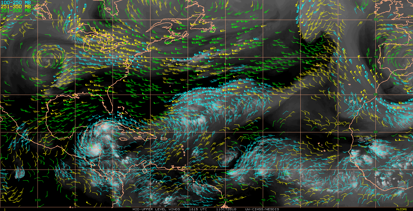
Man..I hate to see such a potentially exciting invest tonight go to waste! I'll explain why I think now within reason this man blow up tonight. The NHC TWO circle incases both areas of vorticity marked here:

I am not entirely sure of the interaction taking place here but I believe two unique vorticity spots may be the result of the huge low pressure in that region. 97L will track just south of a nasty area of shear and overall I would say the pattern is looking good and it finally tomorrow appears to be getting at its best, when wxman predicted.
Black IR signature and a huge expanding convective envelope ensures that at the very least the area at 60W will be an area to watch overnight...
0 likes
-
cycloneye

- Admin

- Posts: 149730
- Age: 69
- Joined: Thu Oct 10, 2002 10:54 am
- Location: San Juan, Puerto Rico
Re: ATL: INVEST 97L - Discussion - (Code Yellow)
8 AM TWO.
SHOWER AND THUNDERSTORM ACTIVITY CONTINUES IN ASSOCIATION WITH AN
ELONGATED AREA OF LOW PRESSURE OVER THE LEEWARD ISLANDS AND THE
ADJACENT ATLANTIC AND CARIBBEAN WATERS. THIS SYSTEM IS CURRENTLY
INTERACTING WITH AN UPPER-LEVEL LOW...AND ANY DEVELOPMENT SHOULD BE
SLOW TO OCCUR DUE TO UNFAVORABLE UPPER-LEVEL WINDS. THERE IS A LOW
CHANCE...10 PERCENT...OF THIS SYSTEM BECOMING A TROPICAL CYCLONE
DURING THE NEXT 48 HOURS AS IT MOVES WESTWARD OR WEST-NORTHWESTWARD
AT 10 TO 15 MPH. REGARDLESS OF DEVELOPMENT...LOCALLY HEAVY RAINS
ARE POSSIBLE DURING THE NEXT DAY OR TWO OVER THE LEEWARD ISLANDS...
THE VIRGIN ISLANDS...AND PUERTO RICO.
0 likes
Visit the Caribbean-Central America Weather Thread where you can find at first post web cams,radars
and observations from Caribbean basin members Click Here
and observations from Caribbean basin members Click Here

-
Gustywind

- Category 5
- Posts: 12334
- Joined: Mon Sep 03, 2007 7:29 am
- Location: Baie-Mahault, GUADELOUPE
000
AXNT20 KNHC 031145
TWDAT
TROPICAL WEATHER DISCUSSION
NWS TPC/NATIONAL HURRICANE CENTER MIAMI FL
805 AM EDT SUN OCT 03 2010
TROPICAL WEATHER DISCUSSION FOR NORTH AMERICA...CENTRAL
AMERICA...GULF OF MEXICO...CARIBBEAN SEA...NORTHERN SECTIONS OF
SOUTH AMERICA...AND ATLANTIC OCEAN TO THE AFRICAN COAST FROM THE
EQUATOR TO 32N. THE FOLLOWING INFORMATION IS BASED ON SATELLITE
IMAGERY...METEOROLOGICAL ANALYSIS...WEATHER OBSERVATIONS...AND
RADAR.
BASED ON 0600 UTC SURFACE ANALYSIS AND SATELLITE IMAGERY THROUGH
1115 UTC.
...TROPICAL WAVES...
TROPICAL WAVE IS ANALYZED FROM 20N59W THROUGH THE NORTHERN
LEEWARD ISLANDS NEAR SAINT KITTS AND NEVIS AND A 1007 MB LOW
NEAR 17N64W TO 13N66W MOVING W 10-15 KT. WAVE IS EMBEDDED
WITHIN AN AREA OF DEEP LAYERED MOISTURE THAT COVERS THE ENTIRE
CARIBBEAN AS DEPICTED ON SSMI TOTAL PRECIPITABLE WATER IMAGERY.
SCATTERED/NUMEROUS STRONG CONVECTION IS WITHIN 90/120 NM W OF
THE LOW CENTERED BETWEEN 15N-18N AND E OF THE LESSER ANTILLES
FROM 15N-17N BETWEEN 57W-59W WITH SCATTERED MODERATE/STRONG
CONVECTION OVER THE REMAINDER OF THE AREA FROM 14N-20N BETWEEN
55W-60W. CLUSTERS OF SCATTERED MODERATE/ISOLATED STRONG
CONVECTION ARE FROM 12N-14N BETWEEN 60W-66W INCLUDING THE
WINDWARD ISLANDS.
$$
PAW
0 likes

Re: ATL: INVEST 97L - Discussion - (Code Yellow)
Coming back to life with a nice looking warm core.
Wind field still looks like a wave, so must be a top-down development.
Rain rate has picked up.
Tangential winds look good.
TUTT to the NE is aiding outflow.


Wind field still looks like a wave, so must be a top-down development.
Rain rate has picked up.
Tangential winds look good.
TUTT to the NE is aiding outflow.
0 likes


Re: ATL: INVEST 97L - Discussion - (Code Yellow)
Interesting times ahead....The area just to the south of PR this morning should continue west towards the western carribean and things look to ramp up over the western carribean in about a week..The area just east of the islands will likely spread west across the northern leewards and PR and spawn genesis N of either PR or DR in about 3 days then head N the NE out to sea.....
0 likes

Re: ATL: INVEST 97L - Discussion - (Code Yellow)
I think that something is trying to form; i don't know exactly where, but that remember me a lot the situation in october 1970 when a huge TD cross very slowly the Eastern Carribean!!! You remember abajan?
Here in the SO tip of Guadeloupe, overcast, heavy showers time to time that came from the SOuest,which is unusual.The ground wind is calm, or from the SSO 3 to 5 kh.After a reading of 1008mb early this morning, my barograf rise to 1011mb, buty steady now..Multiple small vortex ???
And the big cloud mass just east of the islands is to watch careffuly.
IMO, a TD may form any where inthe East carribean chain..Just an amateur opinion..
STAY TUNED
0 likes
Who is online
Users browsing this forum: No registered users and 42 guests