Looking Good

This is the general tropical discussion area. Anyone can take their shot at predicting a storms path.

Moderator: S2k Moderators
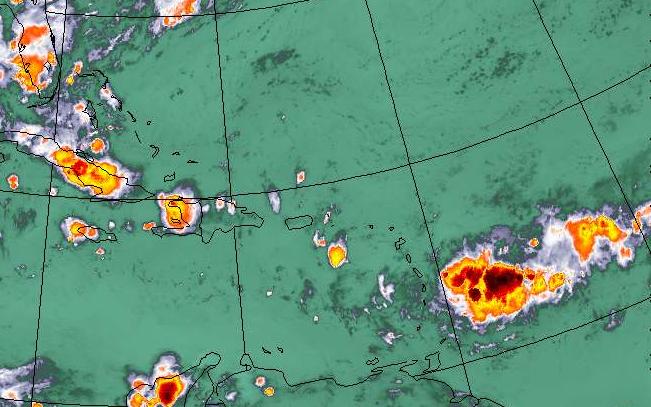
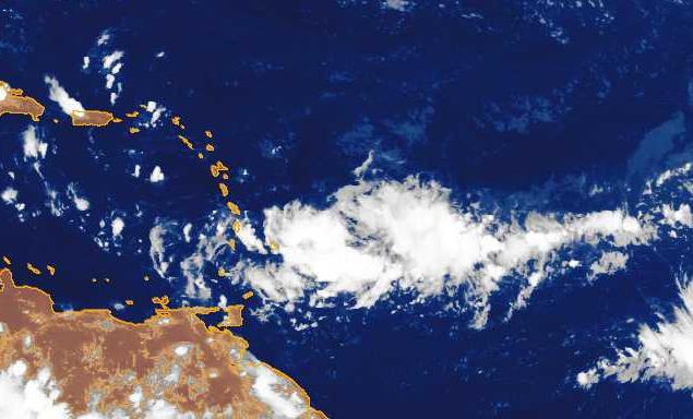
Forum rules

The posts in this forum are NOT official forecasts and should not be used as such. They are just the opinion of the poster and may or may not be backed by sound meteorological data. They are NOT endorsed by any professional institution or STORM2K. For official information, please refer to products from the National Hurricane Center and National Weather Service.

Help Support Storm2K
Message
Author
chadtm80

Looking Good

#1 Postby chadtm80 » Tue Aug 19, 2003 7:26 pm

Well its got the convection it needs... Now where the heck is the spin????


Image

Image


Also here is the link to Buoys in the area :D http://www.storm2k.org/Weather-Central/ ... n_bouy.htm
Last edited by chadtm80 on Tue Aug 19, 2003 7:48 pm, edited 1 time in total.
0 likes   

chadtm80

#2 Postby chadtm80 » Tue Aug 19, 2003 7:40 pm

Image
Last edited by chadtm80 on Tue Aug 19, 2003 8:43 pm, edited 1 time in total.
0 likes   

User avatar
wxman57
Moderator-Pro Met
Moderator-Pro Met
Posts: 22979
Age: 67
Joined: Sat Jun 21, 2003 8:06 pm
Location: Houston, TX (southwest)

Convection

#3 Postby wxman57 » Tue Aug 19, 2003 7:55 pm

Actually, I see the unstable convection as its main problem. Taking a look at the full day's IR loop, convection that had been firing along the eastern portion of the wave began to fire near the leading edge late this afternoon. But the convection isn't very stable. Just in the last few frames, there is evidence that cloud tops are once-again warming - an indication that this new flare-up may be declining soon. The convection needs to stabilize around a single point for greater than just a few hours for development to proceed, and that hasn't happened yet.
0 likes   

Steve H.
Category 5
Category 5
Posts: 2146
Joined: Sat Oct 19, 2002 9:06 am
Location: Palm Bay, Florida

#4 Postby Steve H. » Tue Aug 19, 2003 7:58 pm

It will come Chad. There is some rotation already which, if the convection continues to expand, will easily work down to the surface. Give it time. This one is destined to cut through the islands I think; either Haiti or eastern Cuba. Don't think it will make it to Jamaica. IF it develops during the next day or two. Cheers!!
0 likes   

chadtm80

#5 Postby chadtm80 » Tue Aug 19, 2003 8:00 pm

Taking a look at the full day's IR loop, convection that had been firing along the eastern portion of the wave began to fire near the leading edge late this afternoon


Its been doing that for the last couple of days actually... Sort of a tug of war thing going on there
0 likes   

ColdFront77

#6 Postby ColdFront77 » Tue Aug 19, 2003 8:04 pm

Unstable convection can eventually lead to stable convection. No matter what "kind" of convection there is, it is still convection that needs to be watched for possible development.

Yes, Chad... a tug of war with this elongated wave. There is convection over some favorable waters of the Atlantic, approaching the islands.

What factors are inhibiting development?
Last edited by ColdFront77 on Tue Aug 19, 2003 8:09 pm, edited 1 time in total.
0 likes   

chadtm80

#7 Postby chadtm80 » Tue Aug 19, 2003 8:06 pm

Just in the last few frames, there is evidence that cloud tops are once-again warming


What loop are you looking at?
0 likes   

User avatar
wxman57
Moderator-Pro Met
Moderator-Pro Met
Posts: 22979
Age: 67
Joined: Sat Jun 21, 2003 8:06 pm
Location: Houston, TX (southwest)

#8 Postby wxman57 » Tue Aug 19, 2003 8:19 pm

chadtm80 wrote:
Just in the last few frames, there is evidence that cloud tops are once-again warming


What loop are you looking at?


I'm looking at our own images. We have a floater going on the disturbance. New images are updated the second they're downloaded from satellite. You can't see it, it's password-protected.
0 likes   

chadtm80

#9 Postby chadtm80 » Tue Aug 19, 2003 8:21 pm

Kewl... Keep us updated!
0 likes   

User avatar
The_Cycloman_PR
Category 1
Category 1
Posts: 316
Joined: Mon Oct 28, 2002 12:10 pm
Location: Puerto Rico

#10 Postby The_Cycloman_PR » Tue Aug 19, 2003 8:22 pm

0 likes   

User avatar
Stormsfury
Category 5
Category 5
Posts: 10549
Age: 53
Joined: Wed Feb 05, 2003 6:27 pm
Location: Summerville, SC

#11 Postby Stormsfury » Tue Aug 19, 2003 8:23 pm

I'm a little concerned about a little bit of a SE'ly upper level surge in winds to the west of the large area of convection around 60º-61ºW, evident on WV imagery, not to mention the Eastern Caribbean in general. If any development will occur, it'll take a couple of days for some organization to occur.

http://www.ssd.noaa.gov/PS/TROP/DATA/RT ... -loop.html
0 likes   

chadtm80

#12 Postby chadtm80 » Tue Aug 19, 2003 10:02 pm

Its becoming obvious to me now as well wxman
0 likes   

Anonymous

#13 Postby Anonymous » Tue Aug 19, 2003 11:07 pm

I was looking at something earlier today and read that the dry air around the wave was pretty much forcing it one way and elongating it and stopping it from developing as fast as it would if all that dry air around it wasn't there. But I am not the expert just passing along what I read.

Toodles
Lea Anne
0 likes   

Steve H.
Category 5
Category 5
Posts: 2146
Joined: Sat Oct 19, 2002 9:06 am
Location: Palm Bay, Florida

LOOKING BETTER!

#14 Postby Steve H. » Wed Aug 20, 2003 7:36 am

Looks like we have an LCC forming with convection building around it as it goes thru the islands. The convection seems to have given birth.
0 likes   

chadtm80

#15 Postby chadtm80 » Wed Aug 20, 2003 7:53 am

I Just saw that and was about to come here and ask about it... It sure looks like it to my "un trained" eye
0 likes   

User avatar
vbhoutex
Storm2k Executive
Storm2k Executive
Posts: 29112
Age: 73
Joined: Wed Oct 09, 2002 11:31 pm
Location: Cypress, TX
Contact:

#16 Postby vbhoutex » Wed Aug 20, 2003 8:09 am

chadtm80 wrote:I Just saw that and was about to come here and ask about it... It sure looks like it to my "un trained" eye


I guess your "untrained" eye is getting better. I have included the apparent development of a circulation center in the Storm2K update. It will be interesting to se if the next update from NHC mentions this since there is no evidence of it in the TWO or TWD so far. Now if we can get you to use both eyes....LOLOLOL!!! J/K :lol:
0 likes   
Skywarn, C.E.R.T.
Please click below to donate to STORM2K to help with the expenses of keeping the site going:
Image

User avatar
ameriwx2003
Category 4
Category 4
Posts: 980
Joined: Tue Jul 22, 2003 10:45 am

#17 Postby ameriwx2003 » Wed Aug 20, 2003 8:15 am

Yes, it sure looks like it is trying to get organized and that huge wave that came off of Africa should be interesting down the road as well:):):)
0 likes   


Return to “Talkin' Tropics”

Who is online

Users browsing this forum: SconnieCane, StormWeather, Ulf and 57 guests