ATL: NICOLE - Ex Tropical Storm - Discussion

Moderator: S2k Moderators

Message
Author
User avatar
artist
Category 5
Category 5
Posts: 9792
Joined: Mon Jun 06, 2005 3:26 pm
Location: West Palm

Re: Re:

#201 Postby artist » Mon Sep 27, 2010 8:12 pm

Evil Jeremy wrote:
cyclonic chronic wrote:most models(take those with a grain of salt) depict this going EAST of s. fl.

Not really. The GFS, UKMET, GFDL, HWRF, and CMC models take this into SFL. Only the BAMs really move this away from the coast, and we know how bad they are to begin with.

then BAMS are really only good for the deep tropical atlantic, thus why they aren't realiable in this case.
0 likes   

Ladylight
S2K Supporter
S2K Supporter
Posts: 54
Age: 60
Joined: Mon Aug 30, 2010 11:01 pm
Location: Palm Beach Gardens Fl (near West Palm)

#202 Postby Ladylight » Mon Sep 27, 2010 8:12 pm

If it becomes an actual storm, when would it be most likely to be around SE Fl? Friday or this weekend?
0 likes   

User avatar
Aquawind
Category 5
Category 5
Posts: 6714
Age: 62
Joined: Mon Jun 16, 2003 10:41 pm
Location: Salisbury, NC
Contact:

#203 Postby Aquawind » Mon Sep 27, 2010 8:14 pm

ULL to the North is lifting out and yet the frontal boundry is getting close to the Yukatan. The front is starting to draw the moisture northward. It will be interesting to see how far the front gets tonight..

http://www.ssd.noaa.gov/goes/east/gmex/flash-wv.html

The Keys are getting some of the moisture already..
0 likes   

User avatar
Evil Jeremy
S2K Supporter
S2K Supporter
Posts: 5463
Age: 32
Joined: Mon Apr 10, 2006 2:10 pm
Location: Los Angeles, CA

#204 Postby Evil Jeremy » Mon Sep 27, 2010 8:21 pm

There are a lot of different opinions on what will happen. Some calling for a non event, some saying moderate TS, and some saying even a hurricane is possible for SFL. Lots of uncertainty here, with the clock ticking down. If there is a hurricane bearing down on Florida in 48 hours (which I don't think will happen), there is little time for people to prepare.
0 likes   
Frances 04 / Jeanne 04 / Katrina 05 / Wilma 05 / Fay 08 / Debby 12 / Andrea 13 / Colin 16 / Hermine 16 / Matthew 16 / Irma 17

User avatar
Vortex
S2K Supporter
S2K Supporter
Posts: 4644
Age: 53
Joined: Fri Aug 01, 2003 9:34 pm
Location: Hilton Head, SC

#205 Postby Vortex » Mon Sep 27, 2010 8:22 pm

Belize a few hours ago had very low pressures...It won't take much once this circulation closes off to ramp up to nicole..


77 °F
Thunderstorm Rain
Humidity: 89%
Dew Point: 73 °F
Wind: Calm
Pressure: 29.62 in (Falling)
0 likes   

User avatar
ObsessedMiami
Category 1
Category 1
Posts: 431
Joined: Tue Aug 31, 2004 8:08 pm
Location: West Kendall, Fl

Re:

#206 Postby ObsessedMiami » Mon Sep 27, 2010 8:23 pm

Evil Jeremy wrote:There are a lot of different opinions on what will happen. Some calling for a non event, some saying moderate TS, and some saying even a hurricane is possible for SFL. Lots of uncertainty here, with the clock ticking down. If there is a hurricane bearing down on Florida in 48 hours (which I don't think will happen), there is little time for people to prepare.


And worse, if it does come, preps will have to be made in torrential downpours.
0 likes   

User avatar
blp
Category 5
Category 5
Posts: 2840
Age: 46
Joined: Thu Sep 09, 2004 7:51 pm
Location: Miami, FL
Contact:

Re: ATL : INVEST 96L - Discussion

#207 Postby blp » Mon Sep 27, 2010 8:26 pm

No kidding... its either sandbags or shutters, both or nothing. Tomorrow will be decision day on which option. I think we are going to get something out of this and most people don't have a clue so this will catch most people of guard.

Evil Jeremy wrote:There are a lot of different opinions on what will happen. Some calling for a non event, some saying moderate TS, and some saying even a hurricane is possible for SFL. Lots of uncertainty here, with the clock ticking down. If there is a hurricane bearing down on Florida in 48 hours (which I don't think will happen), there is little time for people to prepare.
0 likes   

Florida1118

Re: ATL : INVEST 96L - Discussion

#208 Postby Florida1118 » Mon Sep 27, 2010 8:26 pm

Image
0 likes   

psyclone
S2K Supporter
S2K Supporter
Posts: 4762
Joined: Wed Aug 24, 2005 9:04 pm
Location: palm harbor fl

#209 Postby psyclone » Mon Sep 27, 2010 8:29 pm

this thing still looks awful IMO. the best convection is over land in the yuc and northern belize. it will be interesting to see if it can burst tonight but so far it has failed to impress and i'm not sure it ever will. i think most of florida will ultimately get little from this with the possible exception of the southeast coast which may get into the heavy rain and the associated flood threat. tough to imagine any meaningful wind threat for anyone. as always things can change quickly but thus far they haven't.

The posts in this forum are NOT official forecast and should not be used as such. They are just the opinion of the poster and may or may not be backed by sound meteorological data. They are NOT endorsed by any professional institution or storm2k.org. For official information, please refer to the NHC and NWS products.
0 likes   

cpdaman
Category 5
Category 5
Posts: 3131
Joined: Sat Jun 10, 2006 11:44 am
Location: SPB county (gulf stream)

Re: ATL : INVEST 96L - Discussion

#210 Postby cpdaman » Mon Sep 27, 2010 8:30 pm

look at that TCHP map....this invest is dancing on dy-no-mite.

http://www.aoml.noaa.gov/phod/dataphod1 ... 0269at.jpg
0 likes   

Florida1118

Re: ATL : INVEST 96L - Discussion

#211 Postby Florida1118 » Mon Sep 27, 2010 8:30 pm

I swear Accuweather...going over board a bit? From This Fri-NEXT Sun, Winds gusting over or at 40mph? 9 days with strong winds...
Last edited by Florida1118 on Mon Sep 27, 2010 8:31 pm, edited 1 time in total.
0 likes   

User avatar
artist
Category 5
Category 5
Posts: 9792
Joined: Mon Jun 06, 2005 3:26 pm
Location: West Palm

Re: Re:

#212 Postby artist » Mon Sep 27, 2010 8:30 pm

ObsessedMiami wrote:
Evil Jeremy wrote:There are a lot of different opinions on what will happen. Some calling for a non event, some saying moderate TS, and some saying even a hurricane is possible for SFL. Lots of uncertainty here, with the clock ticking down. If there is a hurricane bearing down on Florida in 48 hours (which I don't think will happen), there is little time for people to prepare.


And worse, if it does come, preps will have to be made in torrential downpours.


that has been my thought. I don't have a feeling one way or the other, but IF, then there is going to be little time for those not following this to prepare, if it pulls itself together.

Ladylight, I think the GFS is showing late this weekend.
0 likes   

User avatar
blp
Category 5
Category 5
Posts: 2840
Age: 46
Joined: Thu Sep 09, 2004 7:51 pm
Location: Miami, FL
Contact:

Re: ATL : INVEST 96L - Discussion

#213 Postby blp » Mon Sep 27, 2010 8:36 pm

Carnival Triumph right over our area of interest. 1 1/2 hours ago....


2010-Sep-28 00:00 N 18°54' W 086°42' 57 14.2 300 2 1001.0

WNW winds....
Last edited by blp on Mon Sep 27, 2010 8:39 pm, edited 3 times in total.
0 likes   

tgenius
S2K Supporter
S2K Supporter
Posts: 1160
Joined: Mon May 15, 2006 5:31 pm
Location: Miami, FL

Re: Re:

#214 Postby tgenius » Mon Sep 27, 2010 8:36 pm

artist wrote:
ObsessedMiami wrote:
Evil Jeremy wrote:There are a lot of different opinions on what will happen. Some calling for a non event, some saying moderate TS, and some saying even a hurricane is possible for SFL. Lots of uncertainty here, with the clock ticking down. If there is a hurricane bearing down on Florida in 48 hours (which I don't think will happen), there is little time for people to prepare.


And worse, if it does come, preps will have to be made in torrential downpours.


that has been my thought. I don't have a feeling one way or the other, but IF, then there is going to be little time for those not following this to prepare, if it pulls itself together.

Ladylight, I think the GFS is showing late this weekend.


It looks by most model accounts this will be a rain event... that said.. if it does become a wind event.. this is where I smile at the $3k I dropped in Accordion Shuters in 2008. :D
0 likes   

User avatar
artist
Category 5
Category 5
Posts: 9792
Joined: Mon Jun 06, 2005 3:26 pm
Location: West Palm

#215 Postby artist » Mon Sep 27, 2010 8:38 pm

Derek's latest tonight-

2 cyclones possible in Caribbean
Posted 9/27/2010 8:06 PM EDT on pnj.com Prod
Showers and storms have increased in the western Caribbean associated with the monsoon trough. However, there is not a well-defined center at the surface. Conditions are favorable for further development for about 24-36 hours as the system moves slowly to the north-northeast. However, once it crosses Cuba, strong upper level southwesterly winds are expected. This would create a strong shearing environment and would limit development. At this time, I do not expect it to cause weakening because there will be forcing from the trough to the west. That said, the chances of this system becoming a hurricane are significantly lower than yesterday. In fact, any development may not be tropical in nature. Given the shear, there is some chance that the system would be subtropical.

The greatest threat at this time is torrential rainfall, flooding, and tornadoes for Cuba and South Florida. Heavy rains are expected for South Florida starting late tomorrow or early Wednesday. Tropical storm force winds are also possible late Wednesday as the low moves near or over the area.

The models are still developing a second cyclone in the northwest Caribbean near the end of the week. This second cyclone may be more intense than the initial cyclone. Guidance tends to keep it lingering in the Caribbean for a few days under favorable environmental conditions. This second system is the type that needs to be monitored very closely this time of year as cyclones often undergo rapid intensification in the northwest Caribbean this time of year.
0 likes   

User avatar
SouthFLTropics
Category 5
Category 5
Posts: 4236
Age: 50
Joined: Thu Aug 14, 2003 8:04 am
Location: Port St. Lucie, Florida

Re: ATL : INVEST 96L - Discussion

#216 Postby SouthFLTropics » Mon Sep 27, 2010 8:38 pm

blp wrote:Carnival Triumph right over our area of interest. 1 1/2 hours ago....


2010-Sep-28 00:00 N 18°54' W 086°42' 57 14.2 300 2 1001.0


Nothing like taking a cruise right through the middle of a developing tropical system! :double:

SFT
0 likes   
Fourth Generation Florida Native

Personal Storm History: David 79, Andrew 92, Erin 95, Floyd 99, Irene 99, Frances 04, Jeanne 04, Wilma 05, Matthew 16, Irma 17, Ian 22, Nicole 22, Milton 24

User avatar
SouthFloridawx
S2K Supporter
S2K Supporter
Posts: 8346
Age: 46
Joined: Tue Jul 26, 2005 1:16 am
Location: Sarasota, FL
Contact:

Re: ATL : INVEST 96L - Discussion

#217 Postby SouthFloridawx » Mon Sep 27, 2010 8:39 pm

Still waiting for something nominal to develop.

http://www.ssd.noaa.gov/goes/east/watl/flash-rb.html
0 likes   

Ladylight
S2K Supporter
S2K Supporter
Posts: 54
Age: 60
Joined: Mon Aug 30, 2010 11:01 pm
Location: Palm Beach Gardens Fl (near West Palm)

Re: ATL : INVEST 96L - Discussion

#218 Postby Ladylight » Mon Sep 27, 2010 8:41 pm

Thanks artist. We are pretty ready and also have shutters that close in 10 minutes which we got after the two storms of 2004 hit us. We were glad to have them for Wilma. I've become gluten free since then for health reasons, so there's a little more prep and less things that stay edible for long periods. I just want to make sure we've got what we need.

Sure looks like it could rain torrentially before the weekend. Now if we do get a wind event, it looks like it would move away quickly, right?
0 likes   

User avatar
blp
Category 5
Category 5
Posts: 2840
Age: 46
Joined: Thu Sep 09, 2004 7:51 pm
Location: Miami, FL
Contact:

Re: ATL : INVEST 96L - Discussion

#219 Postby blp » Mon Sep 27, 2010 8:42 pm

Background pressures are really low. I can't remember 1001mb pressure and nothing of real substance. Also noticed the WNW winds.... It is slowly getting going.....

SouthFLTropics wrote:
blp wrote:Carnival Triumph right over our area of interest. 1 1/2 hours ago....


2010-Sep-28 00:00 N 18°54' W 086°42' 57 14.2 300 2 1001.0


Nothing like taking a cruise right through the middle of a developing tropical system! :double:

SFT
0 likes   

User avatar
GCANE
S2K Supporter
S2K Supporter
Posts: 11496
Joined: Mon Oct 22, 2007 8:03 am

Re: ATL : INVEST 96L - Discussion

#220 Postby GCANE » Mon Sep 27, 2010 8:46 pm

The whole vortex with this is very broad as seen in 850mb vorticity / MIMIC-TPW convergence and UL troposphere temp anomoly.

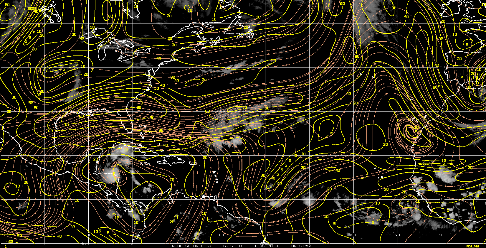
One thing that would help this spin up is to have the anti-cyclone move over the LLC.

That would force the dynamic tropopause to raise over the LLC and stretch the vortex column.

Because of conservation of potential vorticity, that in turn should cause the core to consolidate and spin faster.

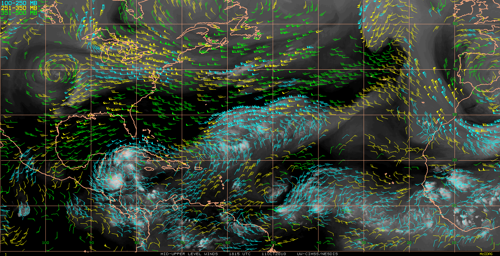
One factor that may help along the way is the moisture column is deepening right around the LLC.

High rain-rate cells have fired over the Yucatan, which should push the anticyclone east toward 96L due to latent heating of the upper troposphere.

Maybe tomorrow with DMAX in the morning and later in the day with solar heating of the cirrus around the LLC, enough diabatic heating could get the anti-cyclone directly over the LLC.

If that happens, it should be off to the races, especially given the good looking outflow that is already in place.


http://cimss.ssec.wisc.edu/tropic/real- ... t72hrs.gif


Image


Image


Image

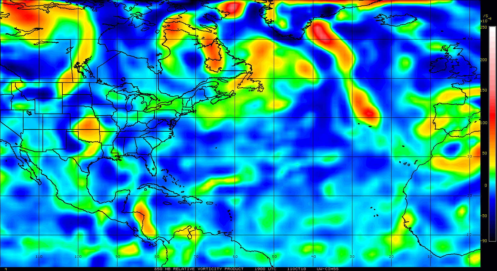
[img]http://www.nrlmry.navy.mil/htdocs_dyn/tc_pages/thumbs/small_size/20100927.2326.f17.x.rain.96LINVEST.25kts-1003mb-186N-867W.72pc.jpg{/img]

Image
0 likes   


Return to “2010”

Who is online

Users browsing this forum: No registered users and 1 guest