ATL: MATTHEW - Ex-Tropical Storm - Discussion
Moderator: S2k Moderators


Re:
alanstover wrote:Seems like some folks here forget that people actually live down here in CA.
And the proximity of water on both sides of us as well as the steep mountains in the interior can turn even a moderate storm into a disastrous rain event.
Though honestly, I´m not sure which would be worse, a direct hit and the mountains tearing up the storm, or having the storm sit along-side pulling moisture up across the mountains from the Pacific. Either way it will be bad.
Thanks to those who have expressed their concern for CA and to all those who post relevant info which helps us in the area be better prepared.
alan
You're right, one thing that people have to take into account is that not only Honduras and Nicaragua may be affected, when a tropical cyclone moves through or close to Central America the whole region may suffer the effects because they pull moisture from the Pacific so Guatemala and El Salvador are in danger too.
0 likes
-
Shuriken
00Z: http://moe.met.fsu.edu/cgi-bin/gfstc2.c ... =Animation
06Z: http://moe.met.fsu.edu/cgi-bin/gfstc2.c ... =Animation
GFS is smokin' crack -- two runs in a row showing the same thing now: Matthew moving to the Y, then mysteriously disappearing or reforming back southwest of Jamaica, then chasing Castro...huh? WTF?
06Z: http://moe.met.fsu.edu/cgi-bin/gfstc2.c ... =Animation
GFS is smokin' crack -- two runs in a row showing the same thing now: Matthew moving to the Y, then mysteriously disappearing or reforming back southwest of Jamaica, then chasing Castro...huh? WTF?
Last edited by Shuriken on Fri Sep 24, 2010 9:54 am, edited 1 time in total.
0 likes
-
johngaltfla

- Category 5

- Posts: 2073
- Joined: Sun Jul 10, 2005 9:17 pm
- Location: Sarasota County, FL
- Contact:
Re: ATL: MATTHEW - Tropical Storm - Discussion
My prayers are with those folks in CA. That kind of concentrated rainfall will cause massive flooding and mudslides. You folks are in our prayers up here.
0 likes
-
plasticup
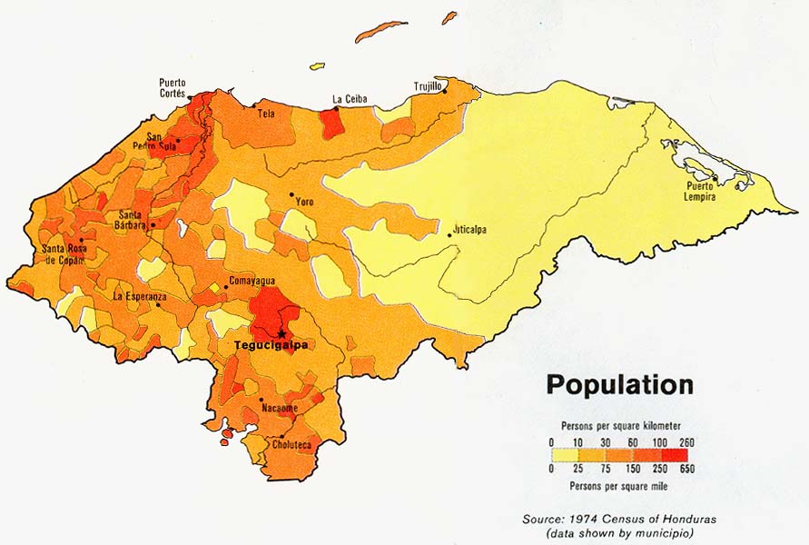
For the curious, this is why a little land interaction doesn't matter, but sweeping farther inland does. Near the northeastern coast, Honduras is flat and sparsely populated. That means little disruption to Matthew's circulation, and light-ish damage. But near the northern coast, Honduras is mountainous and populated, which mean hurricanes get torn apart, rainfall increases, and there are lots of people to be affected:

0 likes


-
dwsqos2


-
SouthDadeFish

- Professional-Met

- Posts: 2836
- Joined: Thu Sep 23, 2010 2:54 pm
- Location: Miami, FL
- Contact:

-
SouthDadeFish
- Professional-Met
- Posts: 2836
- Joined: Thu Sep 23, 2010 2:54 pm
- Location: Miami, FL
- Contact:
does anyone think the area of upper divergence between the upper low over the DR and the anticyclone from mathew spawns a secondary low?
0 likes
Personal Forecast Disclaimer:
The posts in this forum are NOT official forecast and should not be used as such. They are just the opinion of the poster and may or may not be backed by sound meteorological data. They are NOT endorsed by any professional institution or storm2k.org. For official information, please refer to the NHC and NWS products.
The posts in this forum are NOT official forecast and should not be used as such. They are just the opinion of the poster and may or may not be backed by sound meteorological data. They are NOT endorsed by any professional institution or storm2k.org. For official information, please refer to the NHC and NWS products.
-
HurricaneQueen

- S2K Supporter

- Posts: 1011
- Age: 80
- Joined: Sat Oct 12, 2002 7:36 pm
- Location: No. Naples, Fl (Vanderbilt Beach area)
Re: ATL: MATTHEW - Tropical Storm - Discussion
johngaltfla wrote:My prayers are with those folks in CA. That kind of concentrated rainfall will cause massive flooding and mudslides. You folks are in our prayers up here.
I'm with John, as are many others on the board. Alan, we don't "forget" our members, their families and friends when weather is threatening them no matter where they are located. You, along with all of your country people, are in our thoughts and prayers.
Be safe and know you are not forgotten. And... please ignore the few insensitive posts.
Lynn
Last edited by HurricaneQueen on Fri Sep 24, 2010 11:58 am, edited 1 time in total.
0 likes
GO FLORIDA GATORS
-
wxman57

- Moderator-Pro Met

- Posts: 23175
- Age: 68
- Joined: Sat Jun 21, 2003 8:06 pm
- Location: Houston, TX (southwest)
Re:
shortwave wrote:does anyone think the area of upper divergence between the upper low over the DR and the anticyclone from mathew spawns a secondary low?
I'm leaning in that direction now, strange as it seems.
0 likes
-
alanstover
- Tropical Low

- Posts: 46
- Joined: Mon Jun 28, 2010 8:40 pm
- Location: Quetzaltenango, Guatemala, CA
quote: Be safe and know you are not forgotten. And... please ignore the few insensitive posts.
Thanks, and we will try to remember you all up there when its your turn!
Actually, I´ve been impressed with the sense of community on this board and the over-all courtesy and kindness that is expressed.
Keep up the good work.
Skies are overcast here, but no rain yet. We are on the Pacific side of the mountains. I haven´t seen any reports from the Atlantic side yet. Will try to post any important developments.
0 likes


-
Aric Dunn
- Category 5
- Posts: 21238
- Age: 43
- Joined: Sun Sep 19, 2004 9:58 pm
- Location: Ready for the Chase.
- Contact:
Re: Re:
wxman57 wrote:shortwave wrote:does anyone think the area of upper divergence between the upper low over the DR and the anticyclone from mathew spawns a secondary low?
I'm leaning in that direction now, strange as it seems.
yesterday I would have said no... but looking at things today its possible..
0 likes
Note: If I make a post that is brief. Please refer back to previous posts for the analysis or reasoning. I do not re-write/qoute what my initial post said each time.
If there is nothing before... then just ask
Space & Atmospheric Physicist, Embry-Riddle Aeronautical University,
I believe the sky is falling...
If there is nothing before... then just ask
Space & Atmospheric Physicist, Embry-Riddle Aeronautical University,
I believe the sky is falling...
Who is online
Users browsing this forum: No registered users and 83 guests